Ascent Certificate
I. Ascent class — rock climbing 2. Ascent area — PAMIR-ALAI, Guamysh ridge 3. Peak 4800 (Karaganda North), East wall 4. Estimated difficulty category — 5A 5. Route characteristics:
- height difference — 800 m;
- route length — 5 km, technical difficulty — 700 m;
- average steepness — 75°
- Number of pitons and anchor placements:
- for belaying — 90 pieces;
- for creating artificial holds — 5 pieces;
- rock pitons — 75;
- anchor placements — 15
- Time to reach the summit — 14 hours
- Number of nights — one
Ascent participants:
- Ovsyannikov V. A., 1st sports category, leader
- Garder O. N., 2nd sports category, participant
- Leis V. R., 2nd sports category, participant
- Team coach: Shkodin V. G., Master of Sports
II. Date of departure on the route: July 19. Date of return: July 20, 1980.
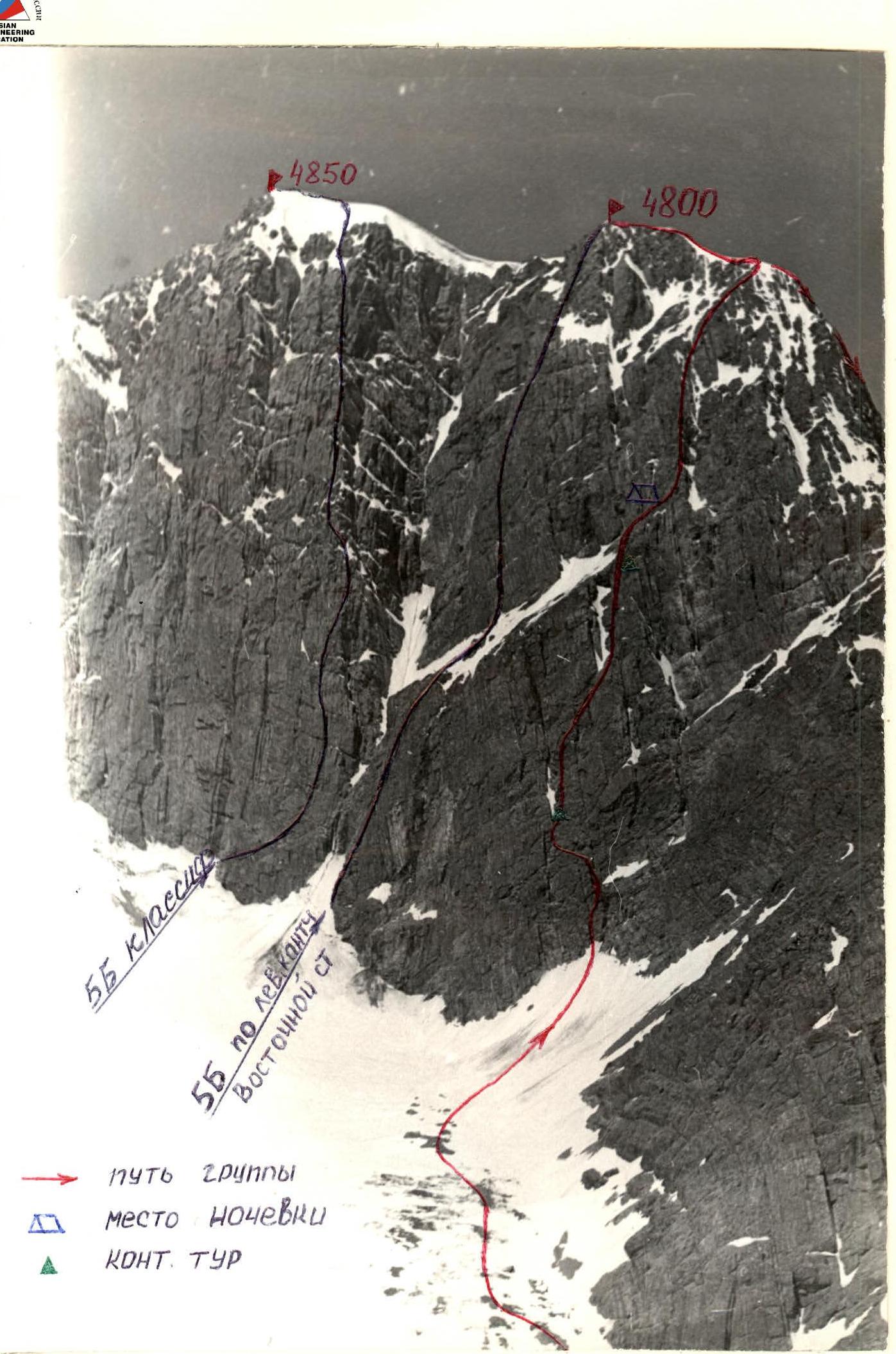
General view of the peak.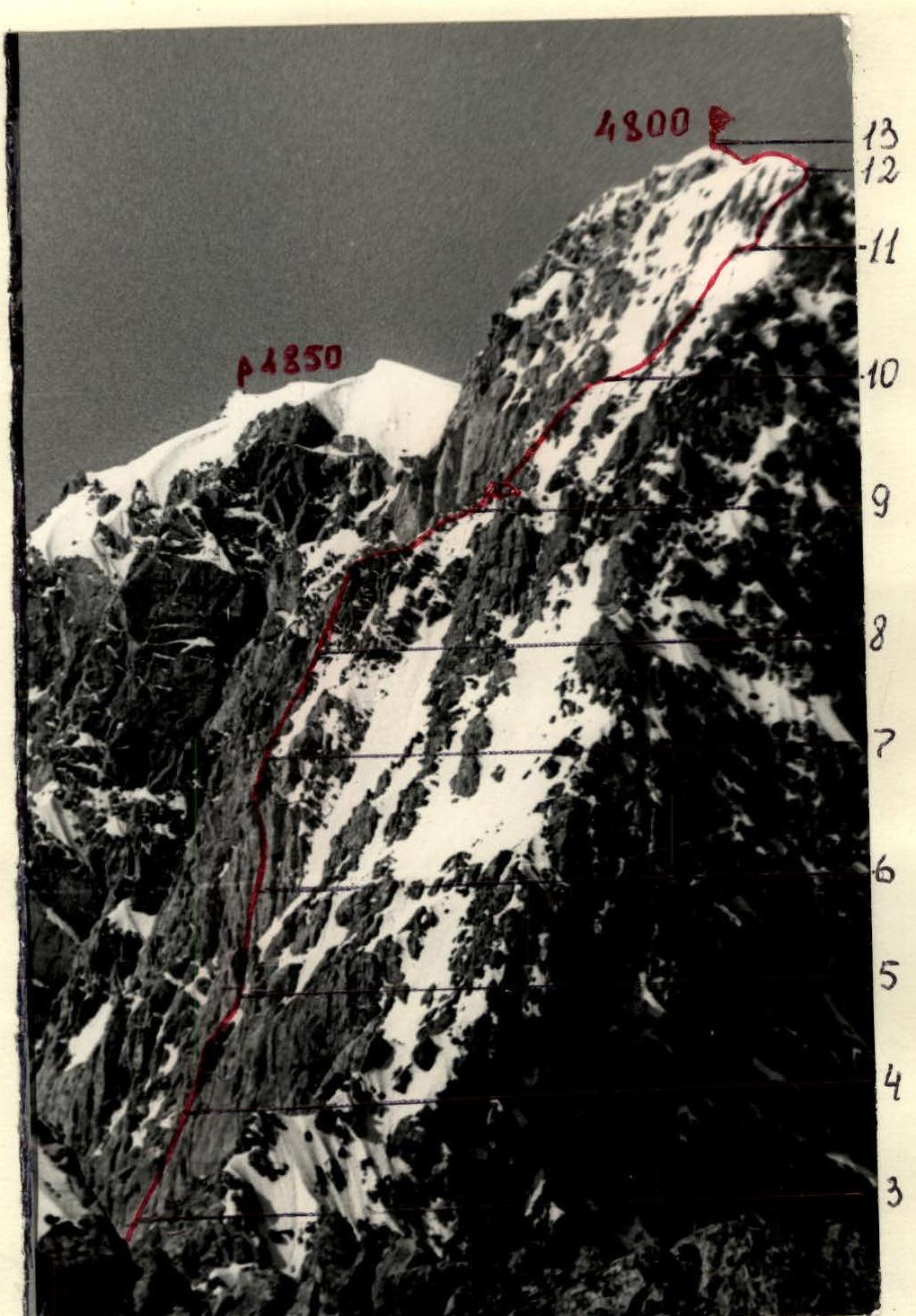
Fig. 3. Route profile. Table of main characteristics of the ascent route.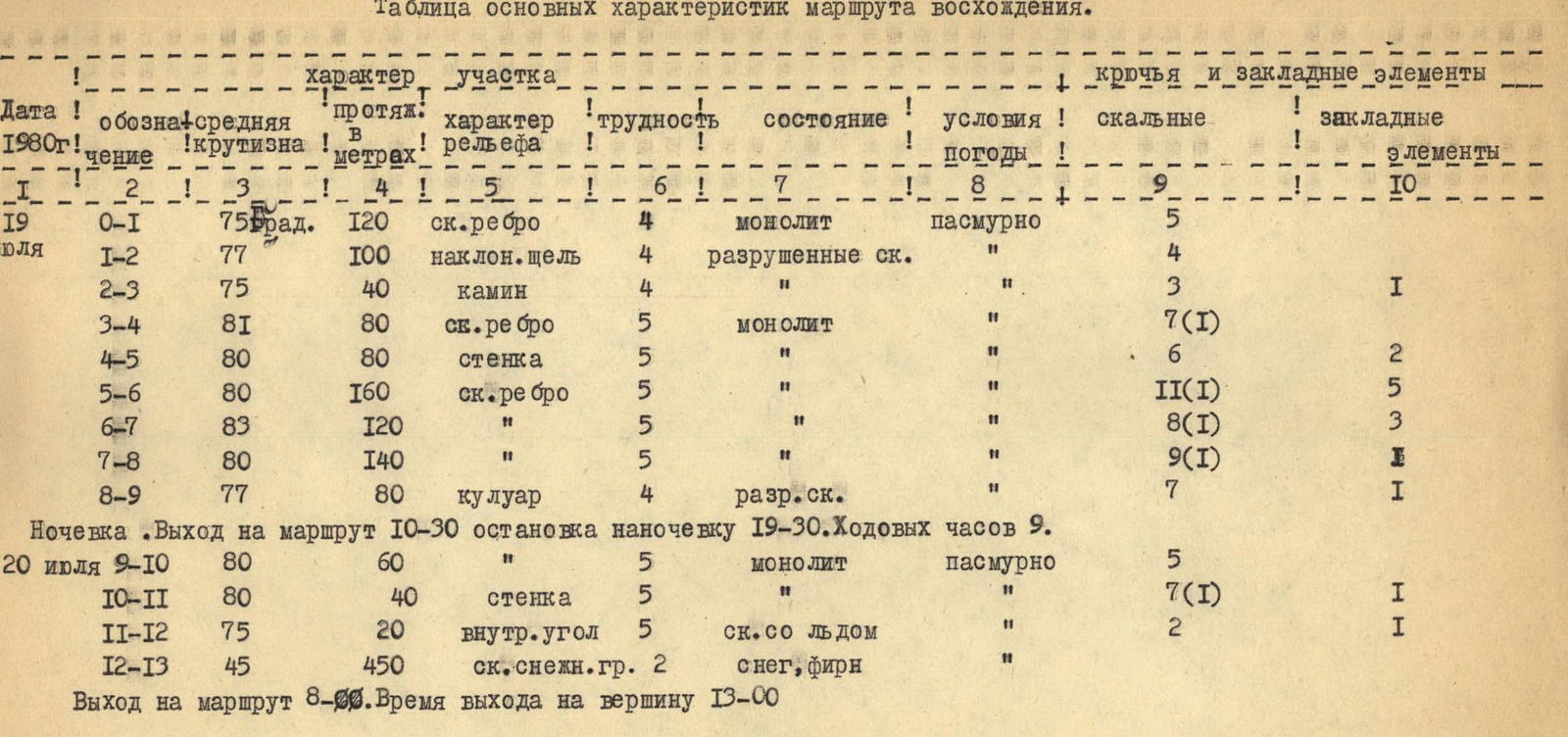
Brief explanations for the table of main characteristics of the ascent route to peak 4800 m (Karaganda North) via the East wall 5A.
3rd ascent of the route.
R0–R1: start of the route on monolithic rocks of medium difficulty, from the bergschrund up a crack from right to left. A ledge.
R1–R2: then a wide crack 4 m long, after the crack slightly left — difficult climbing and then up destroyed rocks of medium difficulty. Exit onto a red rock 10 m long.
R2–R3: along the ledge to the right to a narrow chimney, up the chimney slightly left.
R3–R4: then direction towards a snow patch (clearly visible from below). On the right at the lower part of the glacier — a control cairn.
R4–R5: the snow patch is bypassed on the right in the direction of travel, to the right and up.
R5–R6: then up 4 ropes along a rocky ridge. Direction towards a red rock against the sky.
R6–R7: further up to the right along inclined ledges, monolithic rocks convenient for belaying.
R7–R8: approach under the red rock. The rock is bypassed on the left and up a crack — difficult climbing (crux).
R8–R9: exit onto a second snow patch resembling an inverted comma. On the right on a ledge — 2 control cairns. From the cairn up along the rocky ridge, leaving the snow patch on the left. Exit onto a large talus ledge. Stopped for the night.
R9–R10: further path to the right up — difficult climbing 40 m, and then exit onto a rocky ridge.
R10–R11: to the right up a steep rocky couloir turns into a wall with overhanging sections (section 2), pass on the right side of the wall onto a narrow ridge.
R11–R12: straight along the ridge, approach under an inside corner, complex climbing. Exit onto a destroyed ridge.
R12–R13: along the destroyed ridge to the sub-summit and then along the snowy ridge with cornices — exit onto the summit of peak 4800.
Descent from the summit along the ridge leading to peak 4800.