
Ascent Passport
- Ascent class — high-altitude technical.
- Ascent area — northern spurs of the Pamiro-Alai ridge, upper reaches of the Guamshi River.
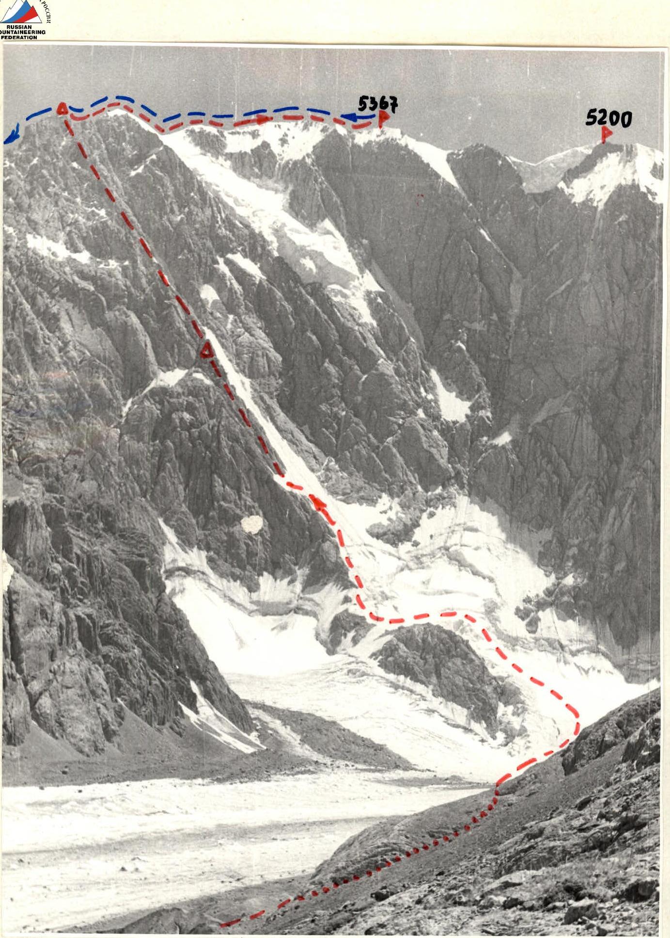
- Peak — 5367 m («Rita»), W spur.
- Proposed difficulty category — 5B.
- Route characteristics: height difference 5367–3900 = 1467 m length of sections with V difficulty category — average steepness.
- Pitons hammered for belay: rock — 122 ice — 28 hanging loops with carabiners — 12
- Number of climbing hours — 29 h 30 min.
- Number of bivouacs and their characteristics:
two bivouacs:
- first bivouac — sitting with belay on pitons;
- second — on the summit ridge on an artificially laid platform.
- Leader — Evgeny Fedorovich Gasilov — CMS (not registered). Participants: Sergey Vladimirovich Golenevsky — CMS (not registered). Nikolai Mikhailovich Ignatiev — 1st sports category. Inessa Vitalievna Mukhina — 1st sports category.
- Team coaches: I.V. Korkin — MS. V.V. Maerkovich — MS.
- Date of departure from the camp July 28, 1978. Return to the camp July 31, 1978.
Description of the Area and Ascent Object
The 5367 m peak is located in the northern spurs of the Pamiro-Alai ridge, in the upper reaches of the Guamshi River. It is a nodal and the highest peak in the area. Several ridges radiate from it:
- The north-eastern ridge leads towards the pass connecting the «Verkhniy Ayлама» glacier to the upper reaches of the Ak-su River.
- To the north-west, a short ridge runs, dividing the «Verkhniy» and «Nizhniy Ayлама» glaciers in their upper parts. These glaciers are the main source of the Guamshi River.
- A ridge also branches off to the south-east.
- Through peaks 5200 m and 5100 m, a ridge extends to the west.
The slopes of the peaks in the area are mainly composed of marbles and marbleized limestones. Where they have a greater steepness, they are quite monolithic. In more gentle areas, where more moisture accumulates, these sections are often heavily destroyed and pose a real danger of rockfall.
The weather in the area is characterized by dry and stable conditions. In the second half of the day, some cloud cover appears, but it usually only covers the top of the 5367 m nodal peak.
The «V. Ayлама» and «N. Ayлама» glaciers have a calm, even surface with shallow and easily avoidable crevasses, making movement across them unproblematic. The cirque of the «N. Ayлама» glacier, where the route began, occupies a small area, surrounded on three sides by steep, almost sheer walls. There is practically no wind here.
The area had not been visited by climbers until recently. The beginning of alpinist exploration can be dated back to 1977. Latvian climbers approached from the south-east, where the «Alai» alpine camp was located in the upper reaches of the Kok-su River. They made the first ascent of the 5367 m peak via the south-eastern ridge and, as the first to do so, proposed naming it «Rita».
In the same year, climbers from the Leningrad «Burvestnik» club approached this massif from the north, led by International Class Master of Sports Yu. Gorenchuk. The Leningraders achieved a number of ascents on unnamed peaks. Their greatest success was the first ascent of the 5200 m peak. They ascended via the centre of the northern wall to the summit over ten days. They were rewarded with gold medals as champions of the Soviet Union in the technical class.
The route to peak 5367 m began in the same cirque, to the left of the «golden» wall. It attracted us with its neatness and logic, pointing straight up like an arrow. The path along the spur was clearly visible, safe, and did not seem problematic.
In the upper part:
- the steepness gradually increased;
- the exit to the summit ridge was not in doubt.
The descent from the summit was planned via the north-eastern ridge onto the «V. Ayлама» glacier. The surrounding peaks appear to be interesting objects for ascent. Many new challenging routes can be laid on them.
Route Description
A brief explanation of the table of the main route characteristics.
The approach to the route goes along the left (orographic) moraine of the «Nizhniy Ayлама» glacier and then crosses the upper plateau of the glacier towards the western spur of the 5367 m peak.
The ascent to the spur, bounded on the right by an ice couloir, goes to the right of a large rock island, bypassing ice crevasses under the couloir. The lower rocks of the spur are bypassed on the right via the ice couloir (sections R0–R3).
After passing the ice «comma» of the couloir (sect. R3–R4) — exit onto the rocks of the spur, as the couloir becomes rockfall-prone. Now the route goes along the rocks of the spur:
- First, an inner corner (sect. R4–R5) leads under the black wall (sect. R5–R6).
- The wall is ascended directly via the right part.
- Next follows a sharp ridge of slabs (sect. R6–R7), leading under the red «feathers».
- Under the «feathers» (sect. R7–R8) — up to the right, then along a steep inner corner (sect. R8–R9) under the rock wall (sect. R9–R10), which is ascended without backpacks.
- Then the route goes into a chimney (sect. R10–R11) and further onto a steep narrow wall (sect. R11–R12), ascended directly, and onto a narrow inclined ledge (sect. R12–R13).
- To the right, on a small platform — a sitting bivouac with belay on pitons.
- From the bivouac — up a narrow crack (sect. R13–R14, hauling backpacks), then traverse left along steep inclined slabs (sect. R14–R15).
- Steep inner corners (sect. R15–R16) lead in the upper part to the main inclined ledge (sect. R16–R17).
- The path left along it leads under the white slab (sect. R17–R18, hauling backpacks).
TABLE OF MAIN ROUTE CHARACTERISTICS
| Date | Section | Length, m | Steepness, ° | Diff. Cat. | Relief | Passage | Weather | Time of departure, stop, climbing hours | Rock Pitons | Ice Pitons | Loops with Carabiners | Bivouac Conditions |
|---|---|---|---|---|---|---|---|---|---|---|---|---|
| July 28, 1978 | R0–R1 | 120 | 10 | 2 | ice slope | simultaneously in crampons | clear | |||||
| R1–R2 | 120 | 20 | 2 | ice slope | simultaneously in crampons | clear | ||||||
| R2–R3 | 200 | 30–45 | 4 | ice couloir | alternately, pitons, belay | — | departure from bivouac at | 3 | 14 | |||
| R3–R4 | 40 | 55 | 5 | ice slope near rocks | alternately | — | moraine at 4:00 | 1 | 3 | |||
| R4–R5 | 150 | 45 | 4 | rocks, inner corner | alternately | — | 20 | |||||
| R5–R6 | 40 | 80 | 5 | rock wall | alternately, fixed ropes | — | stop for | 5 | ||||
| R6–R7 | 20 | — | 3 | sharp ridge of slabs | alternately | — | bivouac at 20:00 | 1 | 1 | |||
| R7–R8 | 80 | 60 | 4–5 | traverse of inner corners | alternately | — | 8 | |||||
| R8–R9 | 60 | 70 | 5 | inner corner | alternately | — | 5 | |||||
| R9–R10 | 20 | 85 | 5 | wall | alternately, hauling backpacks | — | 3 | |||||
| R10–R11 | 40 | 85 | 5 | chimney | alternately, fixed ropes | — | 6 | sitting bivouac with belay on pitons | ||||
| R11–R12 | 30 | 80 | 5 | narrow wall | alternately | — | 3 | |||||
| R12–R13 | 40 | 60 | 4 | narrow inclined ledge | alternately | clear | 2 | 1 | ||||
| Total climbing hours for the day | 16 h | 57 | 17 | 2 | ||||||||
| July 29, 1978 | R13–R14 | 30 | 90 | 5 | narrow crack | alternately, hauling backpacks | clear | 6 | ||||
| R14–R15 | 30 | 45 | 5 | inclined slabs | alternately | — | 6 | |||||
| R15–R16 | 70 | 70 | 5 | inner corner | alternately, fixed ropes | — | departure from bivouac at 9:00 | 13 | ||||
| R16–R17 | 30 | 75 | 2–4 | scree horizontal ledge | alternately | — | 2 | |||||
| R17–R18 | 30 | 80 | 5 | wall | alternately, hauling backpacks | — | 6 | |||||
| R18–R19 | 60 | 40 | 4 | ridge of the spur | alternately | — | 3 | 2 | ||||
| R19–R20 | 70 | 30 | 3 | scree couloir | alternately | — | stop for bivouac | 5 | 1 | |||
| R20–R21 | 30 | 90 | 5 | wall | alternately, hauling backpacks | — | 3 | |||||
| R21–R22 | 20 | 70 | 5 | traverse of slope under overhanging rock | alternately, fixed ropes | — | at 20:00 | 5 | ||||
| R22–R23 | 60 | 70 | 5 | inner corner | alternately, fixed ropes | — | 3 | |||||
| R23–R24 | 30 | 80 | 5 | wall | alternately, fixed ropes | clear | 3 | |||||
| R24–R25 | 70 | 50 | 3–4 | scree couloir | alternately | — | 4 | 1 | ||||
| R25–R26 | 80 | 50 | 3–4 | ridge of the spur | alternately | — | 5 | |||||
| R26–R27 | 70 | 60 | 4 | scree couloir | alternately | — | 1 | |||||
| R27–R28 | 40 | 30 | 3 | ridge of the spur | simultaneously | — | — | bivouac on the ridge on an artificial platform | ||||
| Total climbing hours for the day | 11 h | 65 | 4 | |||||||||
| July 30, 1978 | R28–R29 | 70 | 40 | 3 | rocks of the upper ridge | alternately | clear | departure from bivouac at 8:00 | — | 2 | ||
| R29–R30 | 40 | 40 | 3 | rocks of the upper ridge | alternately | — | — | 1 | ||||
| R30–R31 | 120 | 50 | 3 | destroyed rocks of the upper ridge | alternately | cloudy | reached the summit at 10:30 | — | 3 | |||
| R31–R32 | 120 | 40 | 4 | ice slope | alternately | — | — | 7 | ||||
| R32–R33 | 400 | 50 | 4 | snow-ice ridge | simultaneously | — | — | 4 | ||||
| Total climbing hours for the day | 2 h 30 min | — | 11 | 6 | ||||||||
| Total climbing hours on the route | 29 h 30 min | 122 | 28 | 12 |
After passing the white slab, the path goes left up along the ridge of the spur (sect. R18–R19) and approaches four red «feathers», separated by couloirs. The ascent goes up the leftmost couloir (sect. R19–R20), leading under a large wall. The wall is ascended directly (sect. R20–R21, hauling backpacks). Next follows a traverse left under an overhanging rock (sect. R21–R22), then an inner corner (sect. R22–R23) leads under the red wall (sect. R23–R24). After ascending, they follow in succession: the main couloir, blocked by a huge rock frozen in ice. The exit into the couloir is through a rock to the right (sect. R24–R25), the ridge of the spur (sect. R25–R26), again the main couloir (sect. R26–R27), and finally, the ridge of the spur, leading to the summit ridge (sect. R27–R28).
At the point of exit to the summit ridge — a good bivouac on an artificially laid platform. Further, the path to the summit goes along the northern ridge of the peak, which then turns west. From the bivouac, the route goes along rocks (sect. R28–R31), then follows an ascent to the ice dome (sect. R31–R32) and is completed by an ascent to the summit along a snow-ice ridge (sect. R32–R33). The path from the bivouac to the summit takes 2 h 30 min.
Descent from the Summit
The descent from the summit initially follows the ascent route back to the bivouac on the summit ridge (at the point of exit from the spur) and continues along the rock ridge to a steep bastion edge. The descent from the bastion is via rappelling under its base to the left (in the direction of descent). Then the path continues along the rock ridge to the junction of the NW and NE ridges.
The descent should be made via the NE ridge, avoiding the temptation to descend left (in the direction of descent) onto snow-ice fields, which lead to ice drops or «ram’s foreheads».
One should move along the upper part of the ridge in the direction of the «V. Ayлама» pass. The descent to the lower pass point, then left down onto the «V. Ayalama» glacier plateau, and, bypassing the NW ridge of the peak from right to left, leads to the base camp.
The descent from the bivouac on the ridge to the «V. Ayalama» glacier plateau takes approximately 16 h.

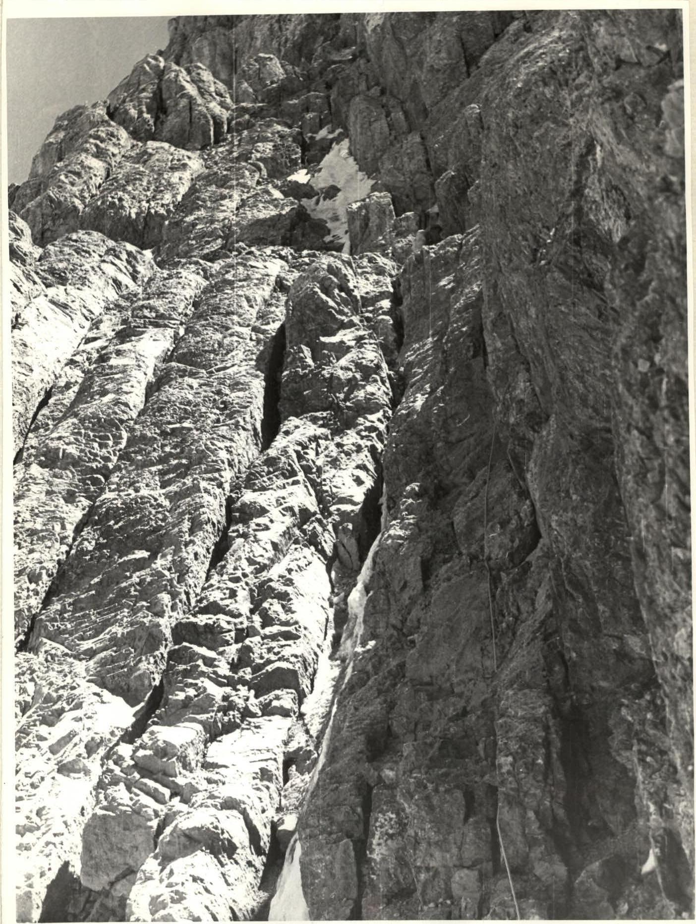
Steep gullies above the «comma». Section R4–R5. 
Rocks of the summit ridge, sect. R30–R31, lead to the snow-ice dome, sect. R31–R32.