PASSPORT
- Technical category
- Alayskiy ridge (Pamir-Alay)
- v. Tekelik via the northern bastion of the eastern ridge
- Proposed 5B cat. diff., second ascent
- Height difference of the wall sections R0–R13 — 440 m, R23–R32 — 255 m; length of sections R0–R13 — 505 m, R23–R32 — 335 m
- Pitons hammered in
- rock 87
- drilled 0
- chocks 13
- ice screws 7
- Team's total climbing hours 32, days 3
- Overnights: 1 — semi-reclining, 2 — reclining
- Captain: Dublyanskiy Yuriy Viktorovich, 1st sports category
Team members:
- Serbenko Vladimir Vladimirovich, 1st sports category
- Pashchenko Alexander Eduardovich, 1st sports category
- Prokopenko Galina Semenovna, Master of Sports
- Getmanov Andrey Ivanovich, 1st sports category
- Sokolov Vladimir Georgievich, 1st sports category
- Coach: Prokopenko Vladimir Ivanovich, Master of Sports
- Departure to the route July 10, 1986 summit July 12, 1986 return July 12, 1986
- Sports club “SO AN”
Wall profile from the right July 8, 1986, N°, “Industar 50–2”, 3.5/50, 2300 m, О₂, h = 4000 m.
Note: Due to the orographic features of the area (cirque), it was not possible to take quality photos.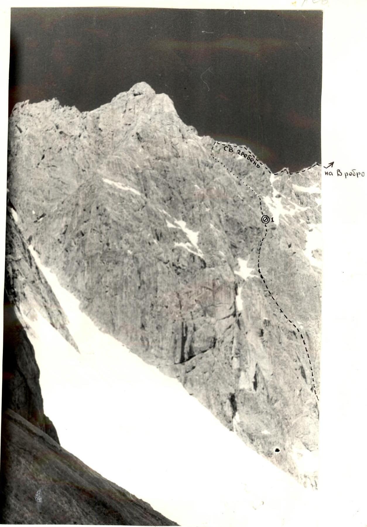
Wall profile from the left July 8, 1986, 1000, “Industar 50–2”, 3.5/50, 1000 m, О₃, h = 4100 m.
Orographic scheme of the area M 1:50000
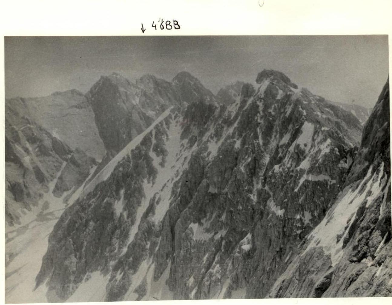
Panorama of nearby peaks — July 11, 1986, 13:00, “Smena-8”, О₄ (photo taken from the NE ridge)
The Tekelik peak (5080) is located in the southern spurs of the Alayskiy ridge in the Kok-su area.
Kok-su mountain area:
- Is the southern neighbor of the long-developed area of the “Dugoba” alpine camp
- Directly borders the Archakanysh gorge
- Has been inhabited and used for grazing livestock since ancient times
- Alpine exploration began relatively recently
Reasons for late alpine exploration:
- Access to Kok-su is via the Alay valley through Daroot-Kurgan
- The well-trodden alpine trail turns into Kashka-su at the foot of Peak Lenin
- The proximity of the popular seven-thousander, which attracted climbers like a magnet, meant that the Kok-su valley waited for visitors until 1977
First ascents:
- The first ascent of Peak “Pravda Vostoka” was made by G. Ovcharov in 1966
Geologist and climber P. Zayd, who worked with a geological exploration party under p. Aidrabek, did a lot to popularize the area.
In 1977, a traveling alpine camp “Alay” worked its first season in the Kok-su valley. This year, a group consisting of V. Kavunenko, V. Bashkirov, A. Kolchin, E. Zayev, V. Ginzburg, and others climbed the main peaks of the area, marking the beginning of the valley's broad sports development.
Over two seasons (1977, 1978), about a dozen wall routes of 5–5B cat. diff. were climbed and classified. Some of these routes were prizewinners at Moscow championships and various Central Councils of Sports Societies.
The Aidrabek-Koltsova cirque and the immediately adjacent Tekelik are considered the gems of the area. Being the highest peaks (5127, 4820, 5080), they have excellent walls with northern and northeastern exposure. Therefore, when selecting objects for training ascents and participation in the RSFSR Championship, as well as the Novosibirsk Region Championship, special attention was given to this mountain node.
The route via the northern bastion of the eastern ridge of v. Tekelik was chosen as the sports object for participation in the regional championship.
Preparation for the ascent
Upon arrival in the ascent area, rock training, snow, and ice training were conducted. These exercises were aimed at both individual technique training (free and technical climbing) and practicing partner interaction on complex terrain. Issues of rope team interaction and teamwork were practiced during training and sports ascents on the 50 Years of the Uzbek SSR peak and the Begichi tooth (4B and 5A categories).
When selecting objects also for ascents, our attention was drawn to the route via the northern bastion of the eastern ridge of v. Tekelik. It makes a good impression due to its large length, high complexity of the lower part, and the presence of diverse technical sections on the route, such as steep walls, extended smooth slabs, snow and ice sections, and ridge sections. The route's objective safety also played a significant role.
The route was carefully studied from overnight camps using a 60x spotting scope. This confirmed the route's objective safety, finalized the path, and developed a tactical ascent plan. The ascent was decided to be conducted without prior processing, both at the start of the route and from intermediate bivouacs.
The first ascent of the route was made by a combined team from the Novosibirsk Regional Sports Committee, preparing for the IV RSFSR Championship in alpinism.
Yu. Dublyanskiy's group started the ascent a day later, using radio consultations.
Team's tactical actions
The team's actions during the ascent largely corresponded to the tactical plan. The team's movement tactics were standard. On the wall sections (R0–R13, R23–R32), the team's load was distributed among 5 backpacks (the first had only safety gear and, due to unstable weather, a down jacket). The high complexity of the wall sections and the team's coordinated actions meant that the first climber rarely had to wait for gear to move forward.
The first climber worked on a double rope (one of which was made in the GDR) with a shock absorber. The other participants moved:
- On double ropes using Jumars
- On single ropes with top-rope protection
Almost constantly on the bastion, it was necessary to climb on two Jumars:
- “leg — chest”
- “leg — leg”
Backpacks were transported on the climbers' backs; there were no hauls.
The first overnight stay was a semi-reclining position on a platform carved into a snow-ice slope under the protection of rocks at the upper belt of the bastion. The second was a reclining position on a snow drift on an osypy ridge.
Both overnights:
- were safe from rockfall
- had rope protection
- team members slept clipped in, wearing helmets
The team was equipped with reliable radio communication with N. Golicov's group (NOSK team) and the camp observers.
The ascent confirmed the preliminary assessment of the route's objective safety. Ensuring safety on the wall sections was achieved through the following measures:
- Where possible, belay stations were chosen under overhangs;
- When this was not possible, and when necessary, backpacks were hung above the stations for protection;
- High-risk areas were traversed quickly.
The safety of the ascent was ensured by thorough route study, detailed tactical planning, selection of appropriate gear, and good tactical and technical preparation of the participants.
| OK | 3 | 4 | |
|---|---|---|---|
| 4 | 4 | 0 | 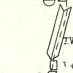 |
| 3 | 3 | 0 | 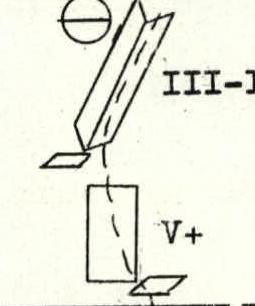 |
| 5 | 4 | 1 | 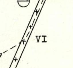 |
| 6 | 4 | 0 | 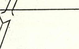 |
| 3 | 6 | 0 |  |
| 4 | 5 | 0 |  |
 | |||
| CK | 3 | D | |
| :--: | :--: | :--: | :--: |
| 1 | 7 | 0 | 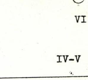 |
| 2 | 4 | 0 | 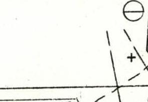 |
| 6 | 0 | 0 | 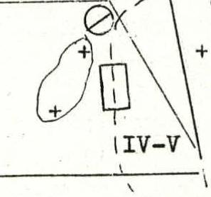 |
| 5 | 1 | 0 |  |
| 5 | 3 | 0 | 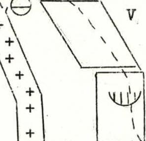 |
| 5 | 2 | 1 | |
| OK | 3 | 几 | |
| :--: | :--: | :--: | :--: |
| 3 | 5 | 0 |  |
| 3 | 6 | 0 |  |
| 2 | 6 | 0 |  |
| 2 | 5 | 0 | 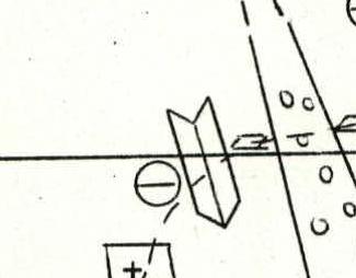 |
| 3 | 4 | 1 | 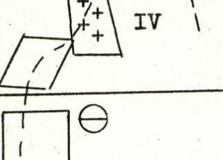 |
| 2 | 3 | 0 |  |
| 0 | 0 | 0 |  |
| :--: | :--: | :--: | :--: |
| 87 | 103 | 7 | |
| OK | 3 | л | |
| 11 | 12 | 4 | |
| 3 | 5 | 0 | |
| 3 | 2 | 0 | |
| 2 | 0 | 0 | |
| 2 | 6 | 0 | |
| 2 | 2 | 0 |
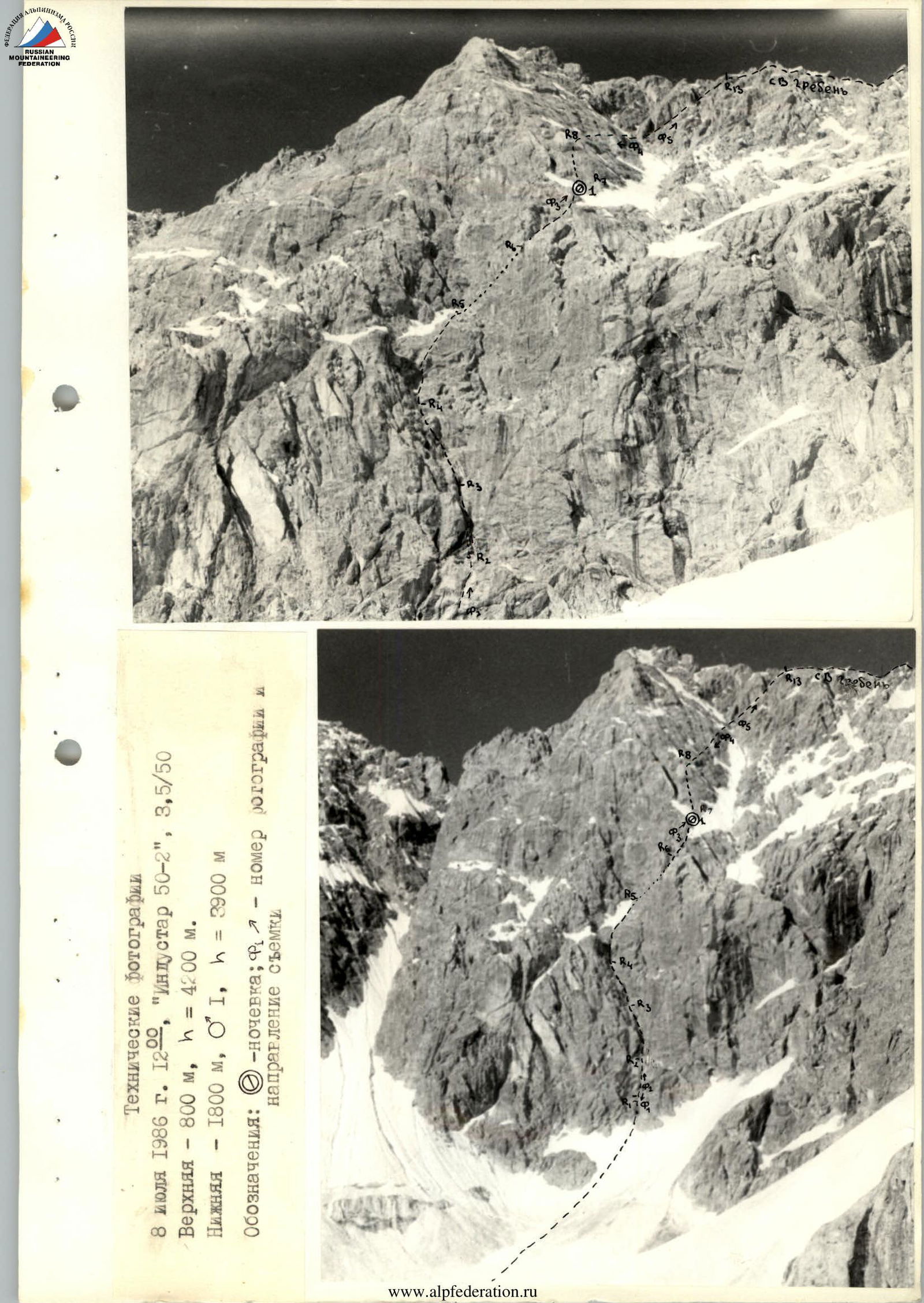
Description by sections. We approach the route in crampons on snow with a slope of 50–60° and a height gain of about 120–150 m. We link up on a rocky- talus shelf under the wall.
Section R0. 40 m, 80°, V–V+. The start of the route is an open internal corner leading to a steep five-meter wall, partially covered with rime ice. After passing the wall, we enter another internal corner. Climbing is very difficult: wet rocks, loose stones. The corner leads to a ledge. From the left edge of the ledge, we climb up a steep 15-meter wall. The wall leads to inclined ledges resembling “ram's foreheads”; here is the belay station. Protection on the section: pitons and chocks.
The route is naturally limited on the left by a cascade of cornices along the first 25 m. A characteristic feature is wet, damp, and partially iced rocks, making climbing in crampons challenging.
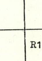
Section R1. 38 m, 50–70°, III–V. Up a 20-meter slab with a slope of about 50° (loose stones!). The rocks have a “ram's forehead” character. The slab leads to a ledge; from its left edge, an internal corner starts with a slope of 65–70° and a length of 15 m. Water flows through the corner. The corner leads to a small ledge with snow and ice; here is the belay station. The location is not very convenient as icicles fall onto the ledge from the cornice above. To protect the belayer, a backpack is hung overhead. Protection: channel pitons and chocks.
Section R2. 40 m, 70–80°, IV–V. From the left edge of the ledge, another large internal corner starts with a slope of about 80°. Like the previous ones, it is wet, making climbing difficult (the first climber wears crampons). After 20 m of tense climbing, another corner joins from the left, smaller and slightly easier (70–75°). We transfer into it and, after 20 m, reach a system of ledges extending to the right. Here is a convenient belay station.
Section R3. 35 m, 50–85°, IV–VI. Along the system of ledges with an overall slope of about 50°, we move right towards a chimney (the chimney is a continuation of the internal corner we started on in the previous section). Water flows down the chimney's walls, and the middle part is filled with ice. The slope of this segment is 80–85°, and the length is 20 m. We assess the complexity as category VI. To the left of the chimney, there is a not clearly defined ridge. The chimney leads to a small sloping ledge where we establish a belay station.
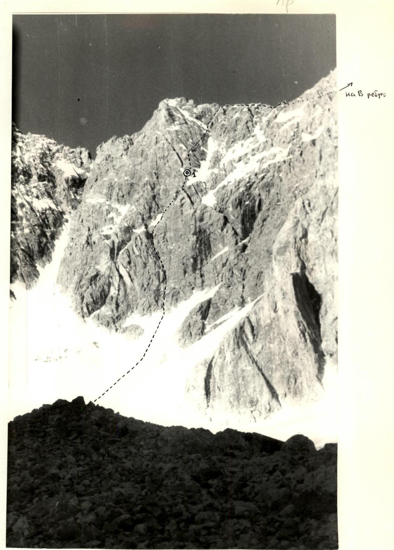
Section R4. 40 m, 50–60°, IV–V+. From the ledge, a non-steep (50°) 15-meter wall starts, presenting a serious difficulty. The rocks are covered in ice and dusted with snow. Climbing is highly tense. The wall leads to a U-shaped opening in the bastion. Here, we remove our crampons and put on boots. After gaining 10 m in height on simple rocks and talus ledges, we move right along an internal corner (60°, IV) filled with snow (loose stones!). The corner is bounded on the left by the bastion wall and on the right by a ridge. After 15 m, the corner leads to a talus ledge. Here is the belay station.
Section R5. 37 m, 60–90°, IV–V+. Directly above the ledge is a seven-meter vertical wall. Climbing is very difficult. Then, there is a continuation of the internal corner. Here, it is dry, with smoothed rocks, a slope of 60–70°, and a complexity of IV–V. After 30 m, the corner leads to a small saddle between the lower belt of rocks and the upper part of the bastion.
Section R6. 55 m, 50°, IV–V. From the saddle, we move up and to the right, first along a five-meter snow ridge, then along a rocky-talus section (loose stones!) towards a characteristic ice-filled wide chimney, to a rocky “tooth” visible against the sky. Under it, we carve out a platform in the snow-ice slope for a semi-reclining overnight stay. The location is fairly safe as the rocks above are monolithic and slightly overhanging.
Section R7. 40 m, 70–90°, V–V+. Directly up from the overnight location, there is a steep (85–90°) 20-meter rock wall. In the upper part, it is intersected by a cornice with a 0.5 m overhang. Climbing is difficult, in crampons. For protection, rock pitons and small stoppers are used. Another 20 m of climbing left and up along a slab with a slope of 70–80°, and the route leads to a small ledge. Here is the belay station.
Above, up to the Tekelik ridge, there are smoothed slabs, sometimes resembling “ram's foreheads”. The main difficulty is the lack of holds, cracks for pitons, and suitable belay locations. Climbing is mostly on friction, in crampons. The route is naturally limited on the right by a large snow couloir running from the ridge.
Section R8. 40 m, 70–75°, IV–V. We continue moving right and up along the slabs.
- The slabs have snow, partially loose stones
- Rocks are smoothed
- We bypass ice patches and small cornices
- Climbing is very tense, with much time spent searching for cracks for pitons
Section R9. 40 m, 45–50°, IV–V. The general direction and character of climbing remain the same. At the end of the section, we approach the edge of a large snow couloir.
Section R10. 40 m, 60°, IV. A 20-meter traverse to the right, crossing the snow couloir. We cross it quickly due to the danger of falling stones. On the opposite side of the couloir, there is an internal corner extending up to the Tekelik ridge. We climb 20 m along it and establish a belay station.
Section R11. 40 m, 60°, IV–V. Continuation of the internal corner. It contains wedged blocks; one of them is a cornice with a 0.5 m overhang, overcome by climbing. The relief is quite fragmented, allowing for reliable protection using pitons and chocks of various types and sizes.
Section R12. 20 m, 60–70°, IV–V. The continuation of the internal corner leads under a two-meter rock wall, exiting directly onto the NE ridge of Tekelik. Here, we remove our crampons and continue in boots.
Sections R13–R21. 320 m, III–IV. We move along the ridge towards the summit tower, using alternating leads. Four rope lengths from the ridge exit, there is the first “gendarme”, bypassed on the right along a ledge 10 m below its top. The second “gendarme” (three rope lengths further) is climbed directly. From it, we rappel (20 m) to the saddle between the NE ridge and the summit tower of Tekelik.
Section R21. 40 m, 45–50°, III–IV. From the saddle, we climb up the wall to a talus ledge. The rocks are of average difficulty.
Section R22. 40 m, 35–45°, IV. We traverse right and up along rocks, then snow (steps), entering a recessed internal corner in the rock wall. Here is a convenient belay station.
Section R23. 40 m, 80°, IV. We traverse right, crossing a large talus couloir to talus ledges. Then, 20 m up along rocks of average difficulty. The relief is fragmented, allowing for reliable protection on chocks and pitons.
Section R24. 40 m, 60–65°, IV. Up along rocks of average difficulty. The section leads to a small rocky ridge with an eastern orientation.
Section R25. 40 m, 45–60°, IV–V. Along the eastern ridge, there is an alternation of short walls, internal and external corners. Climbing is of average difficulty, sometimes slightly higher.
Section R26. 40 m, 45–60°, IV–V. Continuation of the eastern ridge. The relief is similar to the previous section. At the end of the section, on a snow-talus ridge, we clear a platform for a reclining overnight stay. The location is convenient, safe, and well-protected from the wind.
Section R27. 20 m, 55–60°, IV–V. Directly above the overnight location, there is a 20-meter rock wall. It is climbed in crampons.
Section R28. 35 m, 50–85°, IV–VI. Directly along the route, there is a rock tower on the eastern ridge. We approach it along a 15-meter inclined slab (50°) with snow. The slab is on the right part of the tower, intersected by a crack. We use it for climbing and protection. Climbing is very difficult. This section is key on the entire summit tower.
Section R29. 40 m, 45°, III–IV. Up 10 m along non-steep rocks of average complexity, then 30 m along a snow ridge on the eastern ridge (cornices on the right!).
Section R30. 40 m, 60°, IV–V. Continuation of the snow ridge on the eastern ridge. After 20 m, the ridge changes orientation to the north. Another 20 m along snow-covered rocks and snow patches.
Section R31. 40 m, IV–V, 60°. The section is a wall with pronounced micro-relief — internal corners, cracks, blocks. The wall leads to a small ridge with an eastern orientation.
Sections R32–R38. 220 m, 35–60°, III–IV. The route follows the left (by direction) side of the eastern ridge. Protection is organized using pitons, chocks, and outcrops. There are snow and ice sections (overcome in crampons). The ridge leads to a snow shoulder on the summit.
From the shoulder, 300–350 m along a snow slope with two small rises to the summit. Movement is simultaneous.
Descent from the summit to the north towards a black talus saddle — 7 rappels along rocks and snow. From the saddle, along a talus slope to the Kemizdykty valley — 1 hour. Then, along trails to the Kok-su valley — 1–1.5 hours.
Technical photographs:
- July 8, 1986, 12:00
- “Industar 50–2”
- 3.5/50
Upper — 800 m, h = 4200 m. Lower — 1800 m, О₁, h = 3900 m.
Conventions:
- — overnight stay;
- — photo number, direction of shooting