
ASCENT DOCUMENT
-
Climbing category — technical.
-
Climbing region — Pamir-Alay. Alay Range.
-
Peak, its height, and ascent route — p. Skalny, 4480 m via the Southwest wall, North ridge.
-
Proposed difficulty category — 3B cat. diff.
-
Route characteristics: height difference — 600 m.
average steepness — 35–40°, length of sections:
- I — 800 m.
- II — 680 m.
- III — 515 m.
- IV — 300 m.
- V — 200 m.
-
Pitons hammered on the route for belay — rock — 20, ice — 0, bolt — 0.
-
Number of climbing hours — 10–12.
-
Number of nights and their characteristics — 0.
-
Surname, name, patronymic of the leader and participants, their sports qualification: Lopatnikov Vladimir Vasilievich — 1st sports category — leader. Usoltsev Yuri Alexandrovich — 1st sports category — participant. Agranovsky German Leonidovich — Master of Sports of International Class — participant. Agranovskaya Olga Germanovna — 2nd sports category — participant.
-
Team coach — Agranovsky German Leonidovich — Master of Sports of International Class.
-
Date of departure and return — July 13, 1978 — July 13, 1978.
July 23, 1978 p. Skalny 3B cat. diff. (V. Lopatnikov)
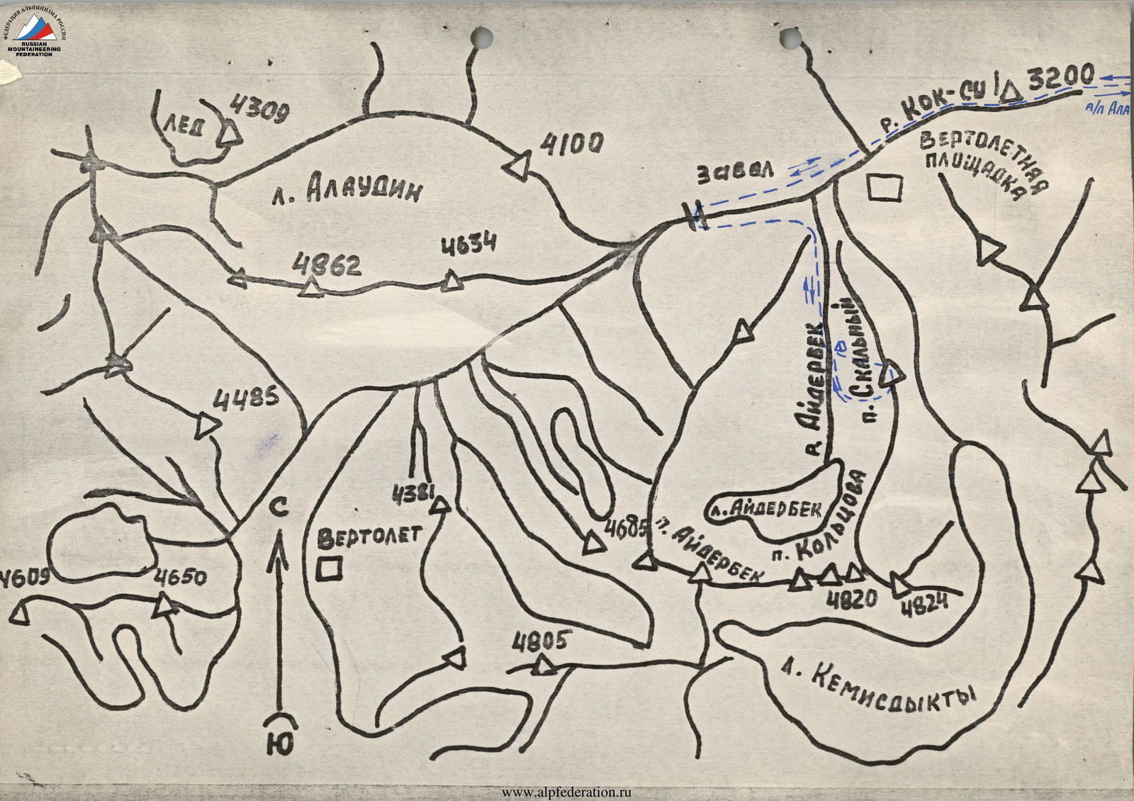
BRIEF DESCRIPTION OF THE APPROACH TO THE ROUTE
From a/l Alay along the left (orographic) side of the r. Koksu to the confluence with r. Dkurgutali — 3–3.5 hours.
Cross the bridge and move to the base camp of geologists — 3 hours.
From the geologists:
- Along the left (orographic) side of the r. Koksu approximately — 2 hours to a natural stone blockage.
- Cross to the right (orographic) side of r. Koksu via a rocky plug.
- Descend down the right bank, following the slopes of p. Molodoy Kommunar.
- Then up along the left (orographic) side of r. Lidarbek to a large transverse reddish moraine.
- Cross the stream under the moraine to the right bank.
Initial bivouac.
From the blockage on r. Koksu to the overnight stay — 2–2.5 hours.
From the overnight stay:
- Ascend the moraine, following the slopes of p. Skalny, and approach a large scree.
- Ascend this scree to the route. From the bivouac — 1 hour.
- Ascend to the saddle (landmark — black rocks on the saddle resembling a human silhouette).
- Then move along the ridge to the summit.
From the overnight stay to the summit — 11–12 hours of work.
Descend via route 2A cat. diff. along the South ridge. From the summit to the overnight stay — 2–2.5 hours.
P. Skalny. 3B cat. diff.
July 23, 1978 (V. Lopatnikov)
DESCRIPTION OF THE ASCENT
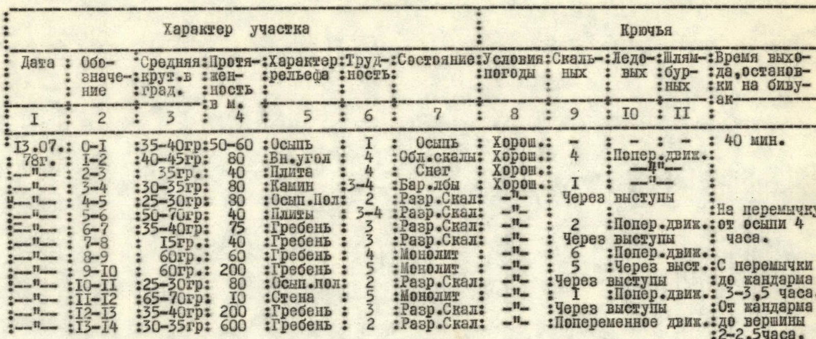
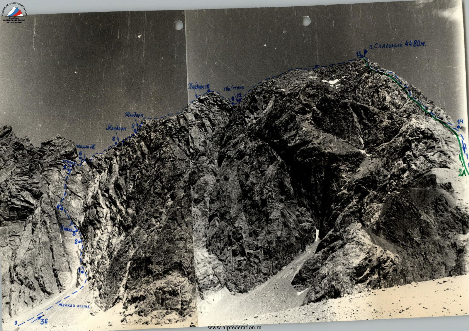
SECTION: R0–R1. From the overnight stay along the moraine of the Aidarbek glacier — 30 minutes. First, ascend the large scree, then the small one to the slabs on the right side, below the rock fall from the 10-3 wall of p. Skalny. Along the scree — 50–60 minutes, steepness 35–40°. 60 minutes from the overnight stay.
SECTION: R1–R2. Very narrow couloir filled with snow and ice. More like an internal corner. Length — 80 m, steepness — 40–45°. 4 rock pitons hammered on this section.
SECTION: R2–R3. Smooth slab — 40 m. No cracks. Preferably pass in galoshes. Steepness — 35°.
SECTION: R3–R4. Chimney. Passed with alternating belay. Length — 80 m. Steepness — 30–35°. Clogged with a stone (piton!).
SECTION: R4–R5. Scree ledges, terraces. Upper part of the section — slabs. Movement with alternating belay. Length — 80 m. Steepness — 25–30°.
SECTION: R5–R6. First, 20 m — wall. Passed in a screw motion from left to right. Broken rocks. Steepness — 50–70°. Medium difficulty climbing. After the wall — 20 m slab (piton!). Exit to the ridge. From the scree to the exit on the ridge — 4 hours.
SECTION: R6–R7. Black rock tower passed on the right, then ascend the slab to the ridge — 40 m (piton!). Preferably pass in galoshes. Along the ridge to the rock tower. The rock tower is bypassed on the left: descend down the ledge — 15 m and up the slab — 20 m (piton!).
SECTION: R7–R8. Movement along a very notched ridge — 40 m. Alternating movement. Belay through a protrusion.
SECTION: R8–R9. Rock tower first head-on (piton 1). Then bypass on the left along a narrow ledge — 40 m (4 pitons). Further, ascend 20 m to the saddle under the rock tower (piton).
SECTION: R9–R10. Rock tower. Wall — 8 m. Difficult climbing (piton!). To the right along a flake (piton) — exit to the ridge. This section — 40 m, steep ascent of the ridge. Difficult climbing (piton!). One rope, and then movement along the ridge with alternating belay, bypassing rock peaks on either side along ledges — to the last rock tower. To the rock tower — 4 ropes. From the saddle along the ridge to the rock tower — 3 hours 30 minutes. The rock tower is passed head-on. Rock wall — 3–4 m, sloping (piton 1). Exit to the rock tower — 1 rope.
SECTION: R10–R11. Descent from the rock tower. Ledges. Descent, following the left side of the rock tower, to the saddle. Alternating belay. Length — 80 m.
SECTION: R11–R12. From the saddle straight head-on, 10 m — wall, difficult climbing (piton!).
SECTION: R12–R13. Ridge, broken rocks, medium difficulty climbing. Exit to the summit ridge — 5 ropes, and along it — to the summit. From the rock tower to the summit — 2 hours.
SECTION: R13–R14. Descent along the South ridge via the classified route 2A cat. diff. to the scree saddle, from it — along the scree towards the Aidarbek glacier, to the glacier. Along the right-bank moraine, following the slopes of p. Skalny — to the overnight stay. From the summit to the initial bivouac — 2–2.5 hours.
P. Skalny. 3B cat. diff.
July 23, 1978 (V. Lopatnikov)
Comments
Sign in to leave a comment