
ASCENT DOCUMENT
-
Ascent class — technical.
-
Ascent area: Alaisky ridge, Keksu river area.
-
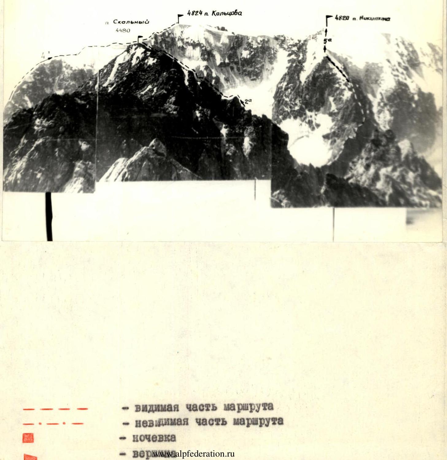
Peak, its height, ascent route — peak 4480.5 m, via the southern ridge (first ascent).
-
Proposed difficulty category — 2A category of difficulty.
-
Route characteristics: height difference — 525 m; rocky route; length of sections 5–6 km/tr; average steepness — 35°–40°.
-
Pitons driven: for belay for creating artificial holding points. Rock — Ice — Bolt —
-
Number of climbing hours — 8.5 hours.
-
Number of nights and their characteristics. One overnight stay on the lateral moraine.
-
Surname, name, patronymic of the leader, participants and their qualification
Leader — Dubina V.N. — III sports category. Participants:
- Sholomko N.F. — Candidate for Master of Sports
- Dobrynin V.S. — II sports category
- Arentyeva T.N. — II sports category
-
Team coach — Zaev E.F.
-
Date of departure on the route and return.
Departure on the route — July 20, 1977. Return — July 21, 1977.
ASCENT DESCRIPTION
From the base camp, located at the confluence of the Aidarbek river and the Keksu river, up the Aidarbek gorge to the overnight stay on the right (orographic) lateral moraine of the Aidarbek glacier. Travel time from camp to overnight stay — 2.5–3 hours.
From the overnight stay:
- Ascend left upwards along the scree couloir towards a rocky outcrop, which is bypassed on the right (section R0–R1).
- Then — ascend the couloir to the pass between the Aidarbek and Kemizdykty gorges (height — 4200 m), where a small snow patch is possible (section R1–R2).
Due to the danger of rockfall, ascent is recommended on the right side of the couloir, sticking to heavily destroyed rock formations. Ascent time to the pass — 1–1.5 hours.
From the pass, movement is in rope teams:
- First, along a narrow couloir located to the left of the southern ridge of the peak (section R2–R3).
- Then — ascend to the right along a narrow chimney with an exit to the southern ridge (section R3–R4).
- After 60 m of ascent along the ridge (simultaneous movement, belay through a ledge) — section R4–R5 — transition to a scree couloir to the right of the ridge, leading to the pre-summit saddle.
- In the lower part, the couloir may be snow-covered (section R5–R6).
- From the pre-summit saddle — move to the right along the rocky ridge (belay through a ledge) and then along the scree to the summit (section R6–R7).
Ascent time from the pass to the summit — 1.5–2 hours.
Descent from the summit is via the ascent route. Descent time to the overnight stay — 1–1.5 hours.
The ascent route is characterized by an abundance of loose rocks, so a "close" group movement is recommended.
Ascent leader Dubina V.N.
GENERAL VIEW OF PIK SKALNY (4480.5)
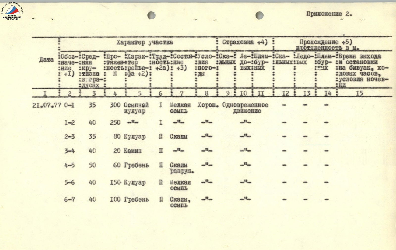
Appendix 2.
Section Characteristics
| Date | Designation (1) | Average steepness in degrees | Length in m. | Terrain characteristics (2) | Difficulty (2a) | Condition (3) | Weather conditions | Belay (4) | Passage (5) |
|---|---|---|---|---|---|---|---|---|---|
| 21.07.77 R0–R1 | 35 | 300 | Scree couloir | I | Fine scree | Good | Simultaneous movement | - | - |
| R1–R2 | 40 | 250 | - | I | - | - | - | - | - |
| R2–R3 | 35 | 80 | Couloir | II | Rocks | - | - | - | - |
| R3–R4 | 40 | 20 | Chimney | II | - | - | - | - | - |
| R4–R5 | 50 | 60 | Ridge | II | Broken rocks | - | - | - | - |
| R5–R6 | 40 | 150 | Couloir | II | Fine scree | - | - | - | - |
| R6–R7 | 40 | 100 | Ridge | II | Rocks, scree | - | - | - | - |
Comments
Sign in to leave a comment