Climbing Passport
- Climbing type — rock climbing.
- Climbing area — Alai Ridge.
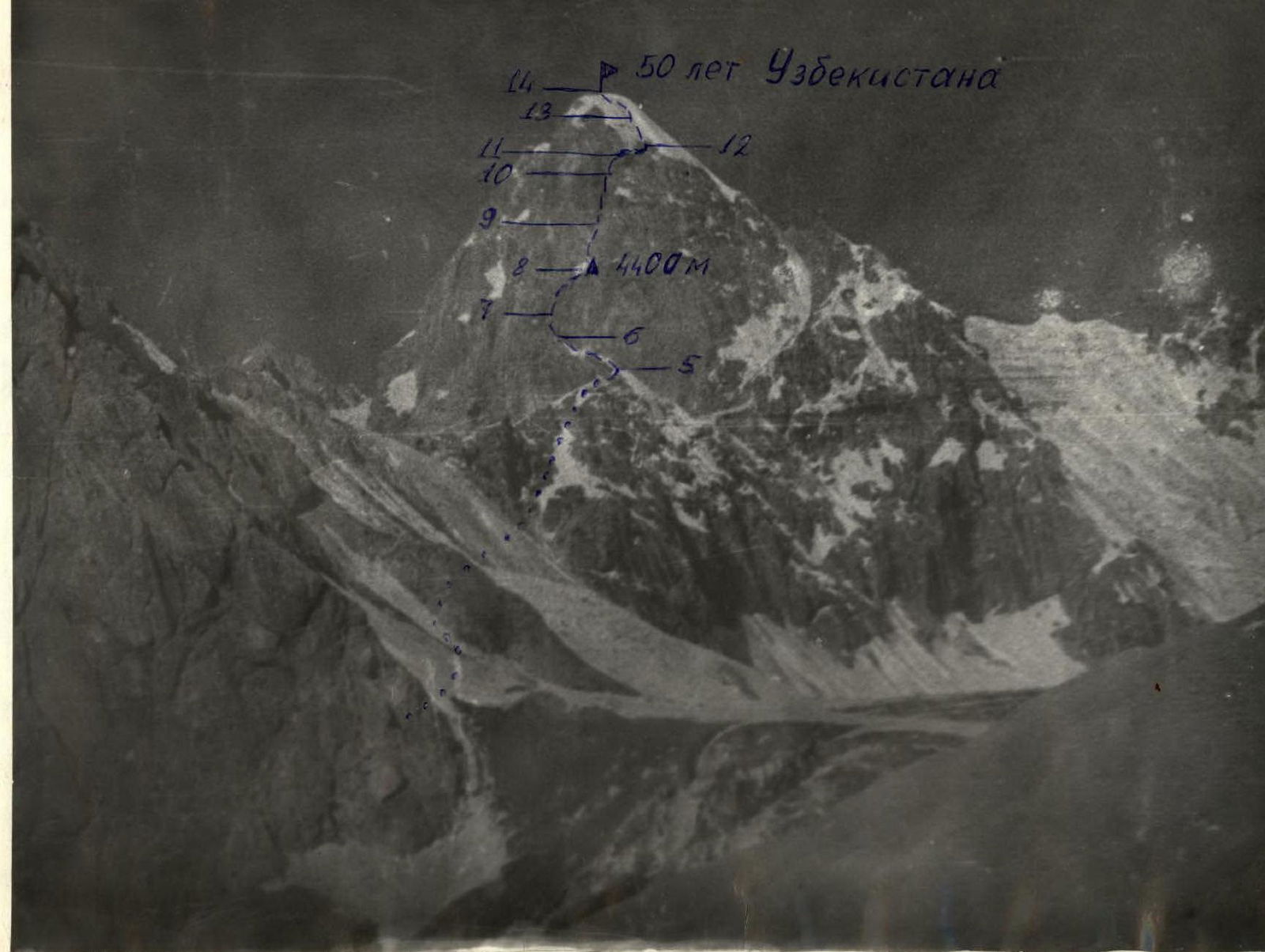
- Peak, its height, ascent route — 50 лет Узбекистана (50 Years of Uzbekistan), 4650 m, via the heart of the NW wall.
- Difficulty category 5A.
- Route characteristics — combined, height difference 850 m, length of 5th category sections 240 m, total 1190 m, average steepness 50°.
- Pitons driven:
- for belaying: rock — 85, ice — 3, bolted — none;
- for creating initial points: rock — 10, ice — none, bolted — none.
- Number of climbing hours — 25 hours.
- Number of nights and their characteristics — one overnight, sitting, at an altitude of 4400 m.
- Surname, name, patronymic of participants and their qualifications:
- Mikhailov E.I. — 2nd sports category — leader
- Kornienko A. — 2nd sports category
- Molnar V. — 2nd sports category
- Naumov S. — 2nd sports category
- Stepanov S. — 2nd sports category
- Team coach Naumov A.F.
- Date of departure and return: departure — July 17, 1978, return — July 19, 1978.
50 лет Узбекистана (50 Years of Uzbekistan)

Appendix № 2
| Date | Section | Average steepness in degrees | Length in meters | Terrain characteristics | Difficulty | Condition | Weather conditions | Rock (belay) | Ice (belay) | Bolted (belay) | Rock (passage) | Ice (passage) | Bolted (passage) | Time of departure, stop for bivouac, climbing hours, overnight conditions |
|---|---|---|---|---|---|---|---|---|---|---|---|---|---|---|
| 8.07.78 | 0–1 | 40° | 120 | firn | 3 | dense in the morning | Clear | via ice axe | - | - | - | - | - | Departure at 6:00 |
| 1–2 | 50° | 80 | rocks | 3 | Unstable | - | 4 | - | - | Free climbing | - | - | 0.5 hours | |
| 2–3 | 30° | 180 | Scree, rocks | 2 | - | - | - | - | - | - | - | - | 0.5 hours | |
| 3–4 | 40° | 80 | Slab | 3 | Covered with loose rocks | - | 3 | - | - | - | - | - | 0.5 hours | |
| 4–5 | 50° | 140 | chimney | 4 | Unstable | - | 8 | - | - | - | - | - | 1.5 hours | |
| 5–6 | 35° | 80 | ledge | 3 | - | - | 5 | - | - | - | - | - | 0.5 hours | |
| 6–7 | 85° | 70 | Wall | 6 | Marble, unstable | - | 20 | - | - | Via ladders (5-) | - | - | 4 hours | |
| 7–8 | 85° | 20 | Cornice, chimney | 5 | With loose rocks | - | 6 | - | - | Free climbing | - | - | 3.5 hours | |
| 8–9 | 70° | 80 | Chimney, slabs | 5 | - | - | 8 | - | - | - | - | - | Stop for bivouac at 20:00. Sitting overnight | |
| 9.07.78 | 9–10 | 70° | 40 | chimney | 5 | marble, unstable | - | 6 | - | - | - | - | - | - |
| 10–11 | 80° | 30 | Wall | 5 | - | - | 10 | - | - | Via ladders (3-) | - | - | 3 hours | |
| 11–12 | 30° | 40 | Crevice | 4 | Monolithic with ice formation | - | 3 | - | - | Free climbing | - | - | 0.5 hours | |
| 12–13 | 50° | 180 | Slabs | 4 | Monolithic with loose rocks | Clear | 8 | - | - | Free climbing | - | - | 3 hours | |
| 13–14 | 50° | 50 | Ice | 4 | Covered with snow | - | - | 3 | - | In crampons | - | - | 1 hour. Reaching the summit at 17:00 |
Brief description of the approach route
To the route
From the base camp at Koshdeba meadow, up the left (orographically) side of Kок-Су (Kok-Su) valley to the bridge over Джугурташ (Dzhugurthash) river (2–2.5 hours). Without crossing the bridge, turn right and ascend along the trail on the left (orographically) bank of Джугурташ river to a characteristic flat stony valley (1–1.5 hours). Reaching its narrowing, turn left and ascend to the first (along the path) cirque of Левинской (Levinskaya) glacier via the left lateral moraine of the glacier to a characteristic sinkhole lake in the cirque (1–1.5 hours).
Here is a convenient place for an overnight stay, with a good view of the entire route.
Brief explanation for the table (Appendix № 2)
Section 0–1
From the bivouac, we move along the moraine to the base of a long snow couloir to the right of the "sickle". We ascend the couloir with alternating belay until we reach a rocky couloir cutting through the lower part of the "sickle". It's better to pass the snow couloir before 8:00 AM (stonefall hazard).
Section 1–2
We traverse the rocky couloir on the left side with careful piton belay, as its bottom is filled with loose rocks. The couloir leads to an osypnaya terrace at the lower part of the "sickle".
Section 2–3
The terrace leads to a long inclined slab, which we traverse with simultaneous belay, leaving the crest of the "sickle" to the right. Through a small chimney, we exit onto the crest of the "sickle" where it turns south.
Section 3–4
The steepness of the "sickle" crest increases here, becoming slab-like, with piton belay. Along the slabs, we approach a wall leading to the upper part of the "sickle". Under the saddle connecting the slabs to the wall, a control cairn should be established; however, prolonged searches for it were unsuccessful due to abundant snow.
Section 4–5
The lower part of the wall is sheer (2 m). Then we move left along an inclined chimney. The chimney leads to the upper part of the "sickle", which is a wide ledge with a series of alternating steps of 2–3 m. The steepness of the ledge is about 35°.
Section 5–6
Moving along the ledge and overcoming encountered steps, we reach the base of a large internal angle. This is the base of the summit bastion, the first critical section.
Section 6–7
The left side of the angle presents smooth marble rocks overhanging at the top, with constant water flow. The entire left part of the angle and its lower middle section are flooded with this water.
The only ascent option is via the center of the right side of the internal angle, deviating left under a cornice (1.5 m) that covers the internal angle from above. The wall is nearly vertical with minor overhangs. Climbing is tense, and finding piton placements is challenging. We take about 4 hours to climb the 70 m wall. Pulling up backpacks takes too much time.
Section 7–8
- We traverse the cornice on the left via a narrow crevice between it and the left side of the internal angle.
- Climbing is very tense due to the crevice being full of "live rocks".
- 2–3 m of smooth rock without holds, forming the cornice's eaves, lead to a narrow chimney (continuing the internal angle).
- Its walls are vertical, converging and forming a minor overhang at the top.
- We climb the chimney along the ridge of its right wall.
- The ridge is beveled and composed of unstable marble rocks that crumble under load.
- Climbing is tense.
Along the continuation of the chimney, we exit into the cirque area of the summit tower wall. It gets dark. To the right of the route, we find an inclined ledge protected from potential rockfall, where we all spend the night.
Section 8–9
We return to the cirque. Through a small chimney in the right part of the cirque, we approach the base of the internal angle.
Section 9–10
Along the internal angle, deviating right and upwards, we ascend to a minor overhang.
Section 10–11
From under the overhang, we move left and upwards along a steep wall, which leads to the wider part of the internal angle. Further ascent is along the center of the angle.
We overcome the lower vertical part using a ladder.
The internal angle becomes less steep, and we exit under the cornice of the summit tower. We pull up our backpacks.
Section 11–12
The cornice is bypassed to the right and upwards via a crevice, which after a few meters turns into a narrow horizontal ledge. Directly above us are steep (45–50°) slabs of the summit ascent.
Section 12–13
We traverse the slabs first from left to right upwards, then from right to left until we reach a tongue of ice leading to the summit.
Section 13–14
In crampons, we ascend the ice and reach the summit in 2–2.5 rope lengths.
Description of the descent from the summit
The descent from the summit is along the western ridge to a saddle with a neighboring peak (3 × 40 m "Delpher"). Then, down the scree with a sharp drop in height, we descend towards Кок-Су (Kok-Su) valley to the trail. The descent takes 3 hours.
The group assesses the complexity of the route as 5A category. For safety reasons, the group recommends climbing the route only in pairs.