Ascent Passport
-
Ascent class: technical
-
Ascent area: southern spurs of the Alay mountain range, Kok-su river valley.
-
Rock massif (C-3) p. Spasatelya with subsequent ascent to v. Mramornaya (West)
-
Difficulty category ≈5A
-
Route characteristics:
height difference — section lengths:
- 3 — 270 m
- 4 — 400 m
- 5 — 60 m
- 6 — average steepness —
-
Pitons hammered for belay:
rock — 37, ice —
-
Number of climbing hours — 12
-
Leader:
Chalin Vladimir Nikolayevich — 1st sports category Participants:
- Galitskiy Grigoriy Semyonovich — CMS
- Khametov Rashid Valiyevich — 1st sports category
- Shipilovskikh Boris Alexandrovich — 1st sports category
- Smolyak Boris Semyonovich — 1st sports category
-
Team coach:
Galitskiy Grigoriy Semyonovich — CMS
-
Date of departure from camp: July 23, 1978 Return to camp: July 24, 1978
Description
on v. Mramornaya (western) from p. Spasatelya via C-3 ridge on July 24, 1978. Team of the Perm Regional Council of the "Zenit" sports society:
| Chalin V.N. | — 1st sports category | — leader |
|---|---|---|
| Galitskiy G.S. | — CMS | — participant |
| Khametov R.V. | — 1st sports category | — participant |
| Shipilovskikh B.A. | — 1st sports category | — participant |
| Smolyak B.S. | — 1st sports category | — participant |
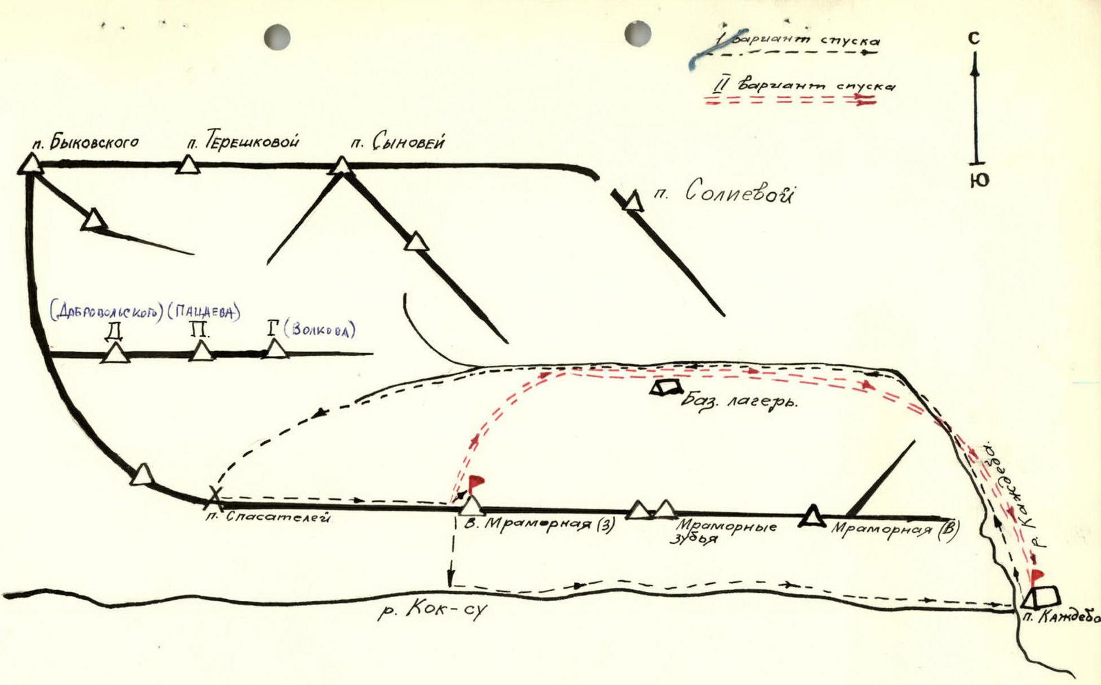
I. Approaches to the route
From the base camp to p. Kazhdeba via a trail along the stream on the right (orographically flowing from the gorge from under p. Soliyeva). Then to overnight stays on the sazane in the circus. Climbing hours — 2 h. From overnight stays (2.5 h):
- Across the moraine
- Across the glacier under p. Spasatelya
- Then exit to p. Spasatelya — 1 h.
II. Route description
C-3 ridge leading from p. Spasatelya to v. Mramornaya (3) is a destroyed rock formation. The left part of the ridge consists of steep broken rock walls with a snow patch at the bottom, where rockfalls often occur. The right part also has heavily destroyed rocks with alternating frequent rockfall-prone couloirs. And only the upper part of the ridge represents a passable rock climbing route. The ridge leading to v. Mramornaya (3) is a rocky destroyed slab. On the left:
- initially a steep ice-snow slope
- further rock walls (rockfalls).
On the right — heavily destroyed rocks, where rockfalls often occur.
III. Explanations for the section table
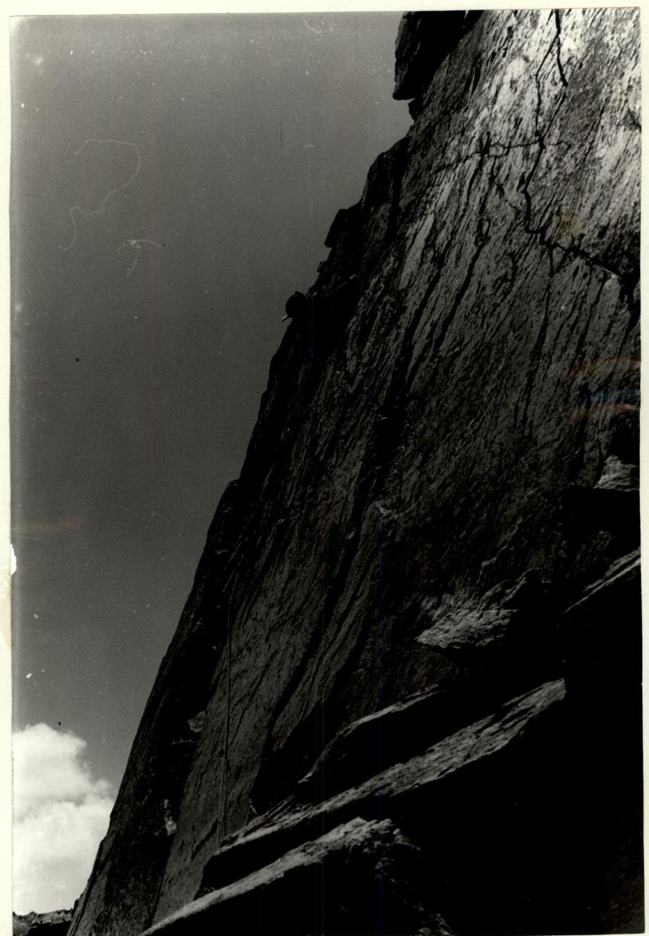
Along the destroyed ridge of p. Spasatelya (R0–R1) with a steepness of 30° under the 1st gendarme (2 ropes). The gendarme (R1–R2) is bypassed along the shelves on the right along the way (piton belay, up to a ledge 160 m). The next gendarme (R2–R3) is passed head-on (20 m) (pitons). From the gendarme (R3–R4) rappel (20 m) to the jumper. 3rd gendarme (R4–R5) — 2 ropes passed upwards to the right along the inner corner (piton belay). On the 3rd gendarme, there is a control cairn. The section (R5–R6) is passed with a descent into the gap (10 m). The 4th gendarme passes on the left head-on (R6–R7). Further along the ridge (20 m) (R7–R8) to the next gendarme. From the 5th gendarme rappel (R8–R9) (40 m) to the scree shelves on the right along the way. Further, about 200 m, bypassing R6, R7 gendarmes along the shelves to the gap. In the gap, rappel (R10–R11) (20 m). From the gap to the left 10 m under the smooth red wall overhanging in the right part. Up the wall on the left (piton belay, climbing complex, 80°–90°, 40 m) — exit to the 8th gendarme. Further 2 ropes along the ridge (the ridge is narrow, cut off by walls) to the 9th gendarme (2nd control cairn). From the gendarme to the right along the shelves down (piton belay) to the ridge. The 10th gendarme is bypassed on the right, then exit to the pre-summit ridge. On the left on the ridge, a steep snow patch turns into ice. In the left part of the snow patch — 2 partially closed bergschrunds (view from the ridge). Along the ridge across the slabs — exit to the summit Mramornaya (3A) (30 min). On the summit, there is a control cairn.
IV. Descent description
From the summit, descent along the ascent route to the 10th gendarme. Behind the gendarme, descent into the couloir leading to the Kok-su river valley. The couloir is prone to rockfalls. At the bottom, the couloir widens, leading to the trail that goes to the base camp p. Kazhdeba along the Kok-su river. 20 min from the end of the couloir in the direction of the base camp — a helicopter pad.
Second descent option:
- From the pass between the 10th gendarme and v. Mramornaya (3), descent is possible along the snowy slope to the moraine under v. Mramornaya.
- For descent via the 2nd option, ice pitons and crampons are recommended.
Team leader V. N. Chalin
The ascent route to v. Mramornaya (West) from p. Spasatelya — 5A category of difficulty.
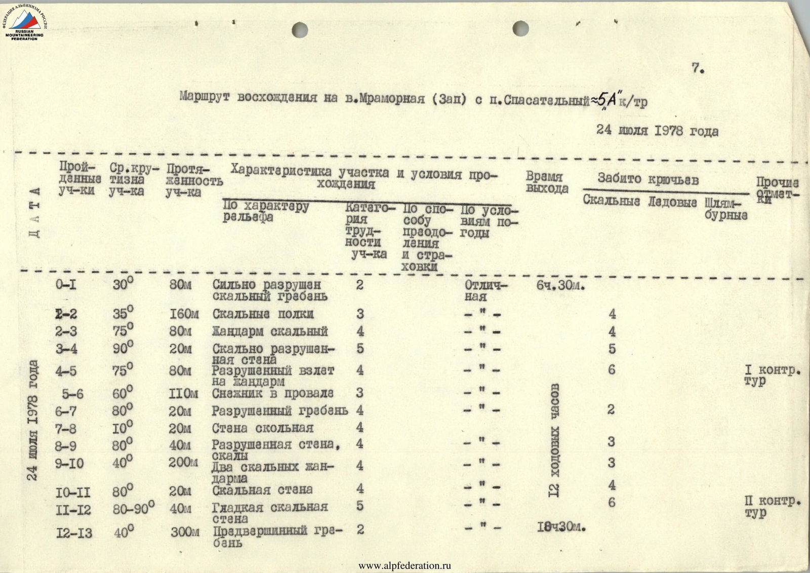
Section R11–R12