Ascent Log
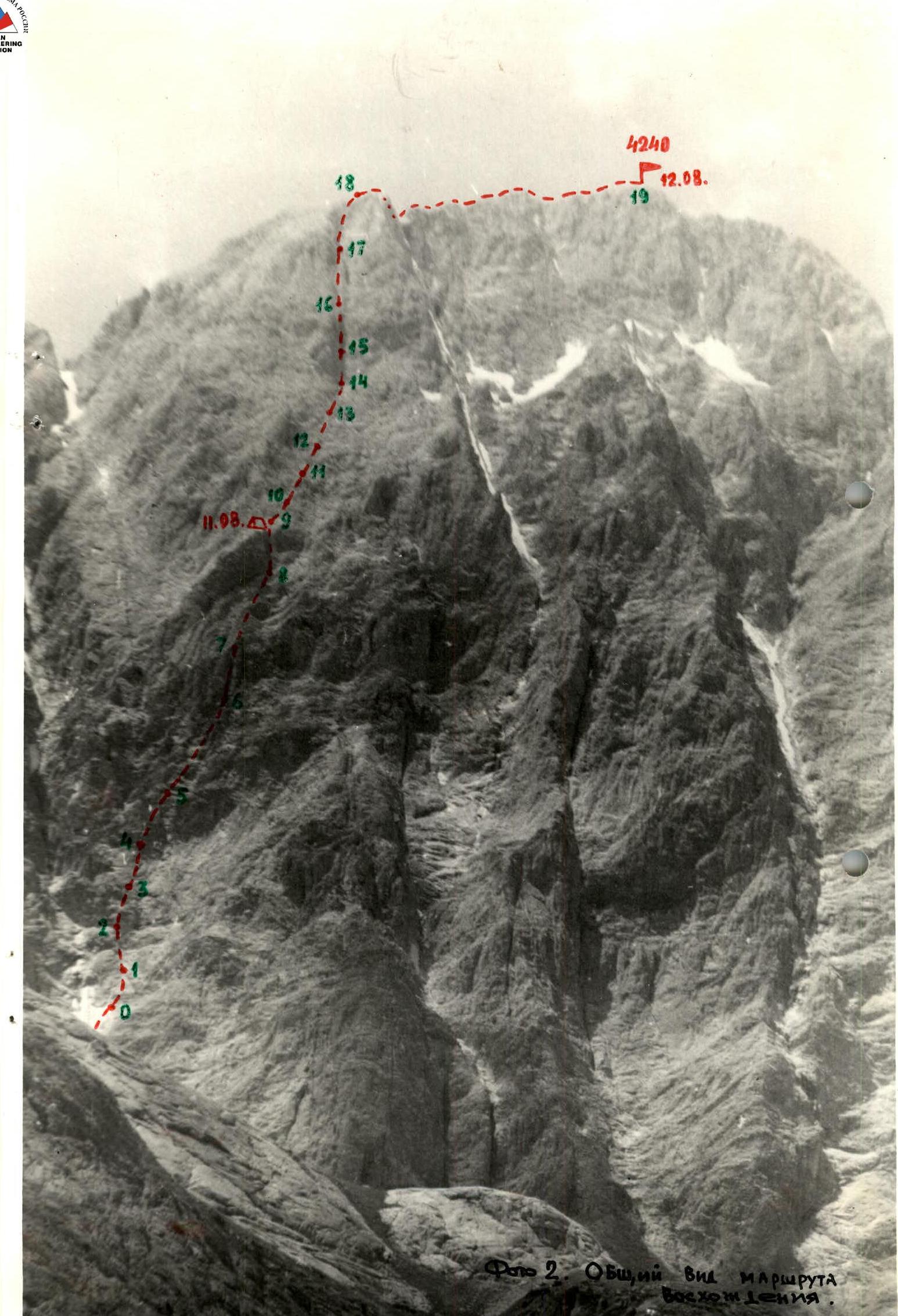
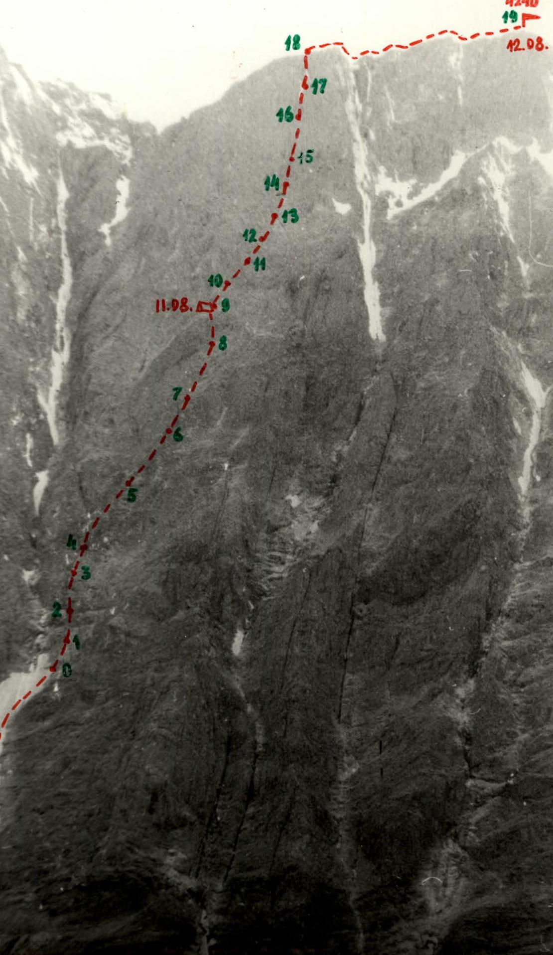
I. Ascent category: rock climbing 2. Region: Pamir-Alay 3. Peak: p. 4240 "Little Prince" via the left part of the Eastern wall 4. Approximate difficulty: 5B category 5. Route description: rock climbing, height difference 620 m (wall section 590 m), average steepness of the wall 71°, length of sections with 5th-6th category difficulty — 700 m 6. Number of pitons used:
| For belay | For ITO |
|---|---|
| Rock | 79 |
| Ice | – |
| Bolt | – |
| Chocks | |
| elements | 30 |
- Total climbing time: 17.5 hours
- Number of bivouacs: 1 (uncomfortable)
- Team members: team leader ZADVORYEV YURIY VASILYEVICH — Candidate for Master of Sports BISHIROV ALEXANDR PETROVICH — Candidate for Master of Sports. BLINOV NIKOLAI NIKOLAEVICH — 1st sports category. TARKHOV EVGENIY VALERYEVICH — Candidate for Master of Sports.
- Team coach: MIKHAILOV ALEXANDR ALEXANDROVICH — Master of Sports.
- Date: August 10–12, 1981
Ascent Area Map for Peak 4240 "Little Prince"
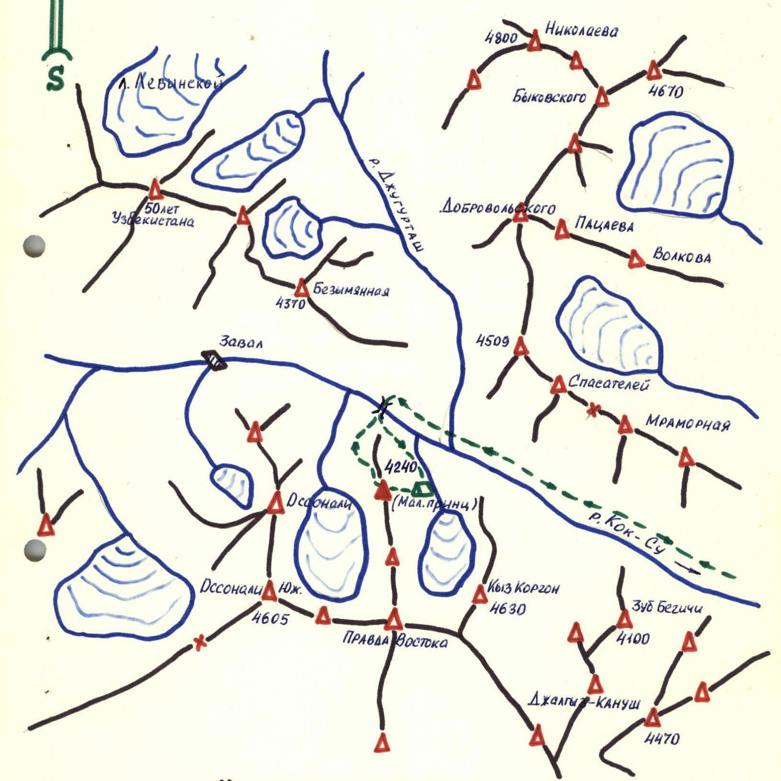
Legend:
- Group's path.
- Bivouac locations.
Table
Main Characteristics of the Ascent Route
Route: p. 4240 "Little Prince" via the left part of the Eastern wall.
Height difference: 620 m (wall section 590 m).
Length of complex sections (5th-6th category difficulty): 700 m.
Average steepness of the route — 71°.
Total number of pitons used — 109, including:
- pitons — 79
- chocks — 30
| Date | Section | Average steepness, ° | Length, m | Terrain description | Difficulty | Condition | Weather conditions | Rock pitons | Chocks | Ice | Bolt |
|---|---|---|---|---|---|---|---|---|---|---|---|
| 0–1 | 55 | 40 | smooth slabs | 4 | semi-deteriorated | good | 3 | 1 | – | – | |
| 1–2 | 62 | 80 | monolithic slab-like rocks | 5 | monolithic | same | 7 | 2 | – | – | |
| 2–3 | 80 | 40 | wall of red rocks | 5+ | semi-deteriorated | same | 6 | – | – | – | |
| 3–4 | 70 | 30 | wall, exit under the cornice | 5 | monolithic | same | 4 | 1 | – | – | |
| 08.81 | 4–5 | 70 | 40 | wall to the left of the cornice | 5 | monolithic | same | 4 | 2 | – | – |
| 5–6 | 63 | 80 | ridge | 5 | deteriorated | same | 6 | 3 | – | – | |
| 6–7 | 80 | 30 | internal corner | 5+ | monolithic | same | 5 | 3 | – | – | |
| 7–8 | 62 | 80 | monolithic slab-like rocks | 5 | monolithic | same | 6 | 4 | – | – | |
| 8–9 | 80 | 20 | internal corner with overhang | 5+ | deteriorated | same | 4 | 2 | – | – |
Start time: 8:00.
Bivouac time: 17:00.
Climbing time, including processing section 9–10 — 9 hours 30 minutes.
Uncomfortable bivouac, 2-person, two people in different locations.
| Date | Section | Average steepness, ° | Length, m | Terrain description | Difficulty | Condition | Weather conditions | Rock pitons | Chocks | Ice | Bolt |
|---|---|---|---|---|---|---|---|---|---|---|---|
| 9–10 | 60 | 20 | slabs | 5 | deteriorated | good | 3 | – | – | – | |
| 10–11 | 70 | 40 | internal corner | 5 | deteriorated | same | 3 | 2 | – | – | |
| 11–12 | 65 | 30 | inclined chimney | 5 | deteriorated | same | 4 | 1 | – | – | |
| 12–13 | 72 | 50 | wall | 5 | monolithic | same | 4 | 2 | – | – | |
| 13–14 | 50 | 20 | internal corner | 5 | deteriorated | same | 3 | 1 | – | – | |
| 14–15 | 75 | 20 | internal corner with overhang | 6 | monolithic | same | 5 | 1 | – | – | |
| 11.08.1981 | 15–16 | 80 | 40 | internal corner | 6 | monolithic | same | 6 | 2 | – | – |
| 16–17 | 75 | 40 | internal corner | 5+ | semi-deteriorated | same | 4 | 2 | – | – | |
| 17–18 | 75 | 40 | internal corner | 5 | deteriorated | same | 2 | 1 | – | – | |
| 18–19 | 20 | 200 | ridge | 2 | deteriorated | same | – | – | – | – |
Start time: 7:00. Summit time: 15:30. Climbing time: 8 hours 30 minutes.
Total route time: 18 hours.
Team coach: Mikhailov A.A.
Team captain: Zadvoryev Yu.V.
| 12 | 4240 |
|---|---|
| 18 | 197 |
| 147 | 15 |
| 15 | 115 |
| 24 | 12 |
| 143 | 14 |
| 11.98. | 15 |
Explanations for the Main Characteristics Table (Route Description)
The approach to the start of the route goes from the river, flowing from the cirque in Kyz-Korgon and Pravda Vostoka, along the scree for 200 m and then along the boundary between the rocks and snow, lying in the couloir, separating p. 4240 and p. 4340, to the upper part of the snowfield (–1.0 + 1.5 hours). Here is the start of the route.
- 0–1 — Monolithic smooth slabs of average steepness, moving from left to right.
- 1–2 — Monolithic slab-like rocks, steepness increases, micro-relief is fragile. Places for piton placement: vertical cracks between huge monolithic slabs-blocks. Exit under the red rock wall.
- 2–3 — The wall is climbed first "head-on" for 5–6 m, then up and to the right for 6–10 m, and above that to the left for a full rope length.
- 3–4 — Wall, slabs — movement towards the cornice.
- 4–5 — The cornice is circumvented on the left, 5 m along the wall, climbing is complex. Exit under the ridge.
- 5–6 — The ridge is psychologically easier to climb than the slabs. Movement from left to right upwards. Approach under the red rocks. Under the internal corner.
- 6–7 — The internal corner is climbed using free climbing (in the absence of snow); places for piton placement are limited. Chocks can be used.
- 7–8 — Gray belt, slabs with limited handholds, slabs are covered with sand, climbing is difficult.
- 8–9 — Internal corner, in the middle part with an overhang, exits to the top of the "perch". Here a control cairn is left. Water is absent. Bivouac is organized. Bivouac is uncomfortable.
On the 1st day, the wall was climbed for 440 m, height difference — 340 m; 45 pitons were hammered, 18 chocks were used.
- 9–10 — Slabs, moving straight up, from the bivouac site a large internal corner is visible, leading to the ridge. Places for receiving and organizing belay stations are uncomfortable.
- 10–11 — Internal corner, leading to an inclined chimney.
- 11–12 — Inclined chimney, 1–1.5 m wide (caution, "live" rocks!) is climbed partly using stemming, the upper part is climbed on the right side.
- 12–13 — The wall is complex to climb. Cracks are deep in the joints of blocks-slabs, a place for organizing a belay station required extending the rope. Leads to the start of the crack.
- 13–14 — Internal corner, climb straight up.
- 14–15 — Internal corner (20 m), in the middle part a 3–4 m section with 90° steepness and two cracks 1 m apart, is climbed using a double rope, pitons are hammered into both cracks. Climbing is very complex. Handholds are absent. The walls of the corner are smooth. Leads to a deep niche.
- 15–16 — Exit from the niche along the left part of the wall and up (40 m) along the wall (80°). Complex.
- 16–17 — System of internal corners, transition from one to another every 4–5 meters along smooth slabs, complex to climb. In the upper part, many "live" rocks.
- 17–18 — Internal corner, leading to the summit ridge.
- 18–19 — Ridge to the right towards the summit (200 m) is climbed simultaneously, belay is from protrusions, a small dip is passed, and then with a slight height gain (30 m) to the summit.
On the 2nd day, 300 m were climbed, height difference — 250 m, 34 pitons were hammered, 12 chocks were used.