
Ascent Passport
- Ascent category — technical.
- Ascent area — Pamir-Alay, Alay ridge, Koksu gorge.
- Peak Ya. Kreuksa (4634 m) via the "perо". First ascent, approximately 5B category of difficulty.
- The route is rocky.
- Route characteristics:
- height difference — 950 m.
- wall section — 450 m.
- length — 1420 m.
- length of sections with 5–6 category of difficulty — 410 m.
- average steepness of the wall section — 75°
- Number of pitons hammered:
- for belay — 69 pcs.
- for I.T.O. — 3 pcs. Number of used chocks:
- for belay — 20 pcs.
- for I.T.O. — 3 pcs.
- Number of walking hours — 22.
- Number of nights — two in a tent.
- Team composition:
- Kavunenko V.D. MSMK — team leader.
- Bashkirov V.L. MS
- Ivanov N.V. MS
- Khankevich A.G. CMS
- Kovanovsky V.A. 1st sports category
- Nagoga M.A. 1st sports category
- Yanchenkov V. 1st sports category
- Team coach: Kavunenko V.D.
- Date of departure — July 8.
Date of return — July 10.
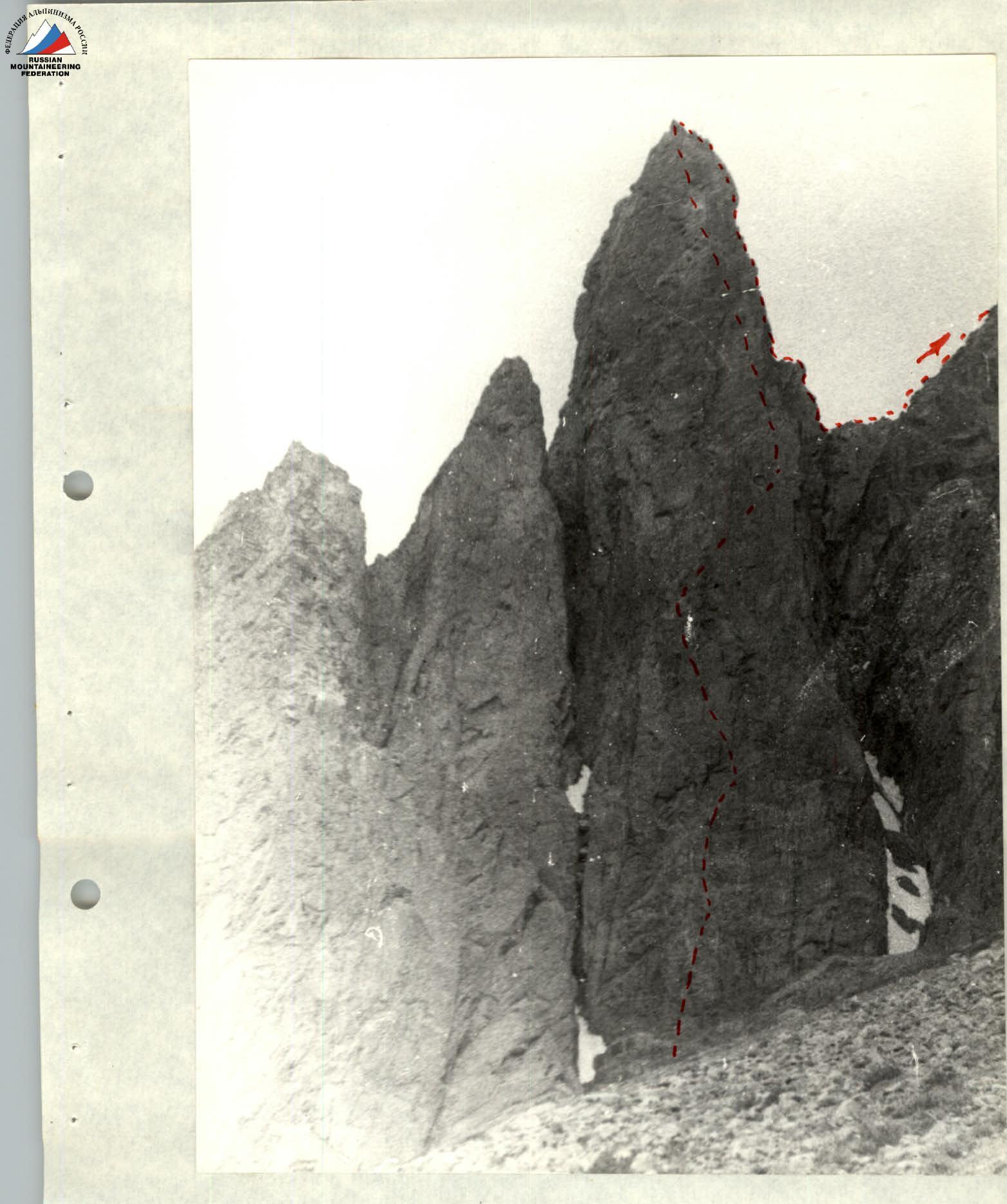
The wall of "pero"
Profile of the upper part of "pero"
Brief geographical description of the area and characteristics of the ascent object
The massif of peak 4634 (Ya. Kreuksa) is located in the southern spurs of the Alay ridge, in the Koksu river valley. Peak Ya. Kreuksa is the easternmost peak in a short spur of the Alay ridge. To the west of the peak is p. Ya. Fabricius (4820 m), to the north of this spur is the Alaudin glacier, and to the southwest is the Koksu river valley.
Peak Ya. Kreuksa has a pyramidal shape, and from the south, it is adjoined by characteristic "feathers" with walls up to 500 m. To the west, the massif is separated by a gap from p. Ya. Fabricius. Towards l. Alaudin, the peak is a series of rock walls resembling faults and short, destroyed ridges. To the east, peak Ya. Kreuksa is a bifurcated ridge descending to the confluence of the Alaudin and Koksu rivers. From the south, apart from the "feathers", there is another 500-meter wall with a chimney. Two classified routes of 5B category of difficulty are laid here:
- via the chimney of the southern wall;
- via the right edge of the chimney.
The prevailing rocks in the area are granites and marble. The massif of peak Ya. Kreuksa is composed mainly of dark reddish granites. These rocks are characterized by a limited number of holds and cracks for pitons. There are sections of absolutely smooth vertical slabs. Passing many sections requires good rock climbing skills.
Description of the route passage
July 8. Today is a reconnaissance and processing day. The approach to the route was not a problem — about an hour from the tent on the banks of the Koksu river up the steep scree to the "pero". The wall begins right from the scree. Its width here, at the bottom, is 120–150 m. On the left and right, the "pero" is bounded by rock gutters, where stones sometimes fly, especially in the second half of the day.
The beginning is quite logical — on the right part of the wall, there are sheer, absolutely smooth walls that can only be climbed with pitons, the left part, although it looks simpler, is dangerous due to stones often flying out of the gutter. Only a 15 m wide section slightly to the left of the middle remains, where individual cracks for hammering pitons are visible, and it seems possible to climb free.
The first 20 m of the R0–R1 section are steep, with a limited number of holds, but wearing crampons makes it possible to climb. The only inconvenience is that most of the cracks are too shallow for a reliable piton, so it takes quite a long time to search.
Then we deviate to the right because an alluring flattening to the left leads 30 m straight into the stone-dangerous gutter. 40 m from the start of the route have been passed when a long (6 m) and fairly wide (0.5–0.8 m) ledge, invisible from below, leading to the right, suddenly opens up. We proceed along it and realize that there are no exits upwards from it — everywhere above the ledge are smooth sheer walls: we have to return, concluding that the ledge, although large, is absolutely useless, and there is no point in going out onto it.
The start of the R1–R2 section is almost a sheer wall with uncomfortable holds, and only crampons help to load the very small recesses in the rock. After 10 m, climbing becomes less tense, there are many cracks, but "live" stones have already begun to appear. At the end of the R2–R3 section, there is a slight flattening and an exit to a small ledge, from which a long (60 m) internal angle begins, going up to the left. It's quite steep, but you can go using stemming, although you need to be very careful because there are many live plugs inside the angle, and the belayer stands right below — there's nowhere to move away. After 30 m, we organize a belay point on a ledge to the right (end of the R3–R4 section).
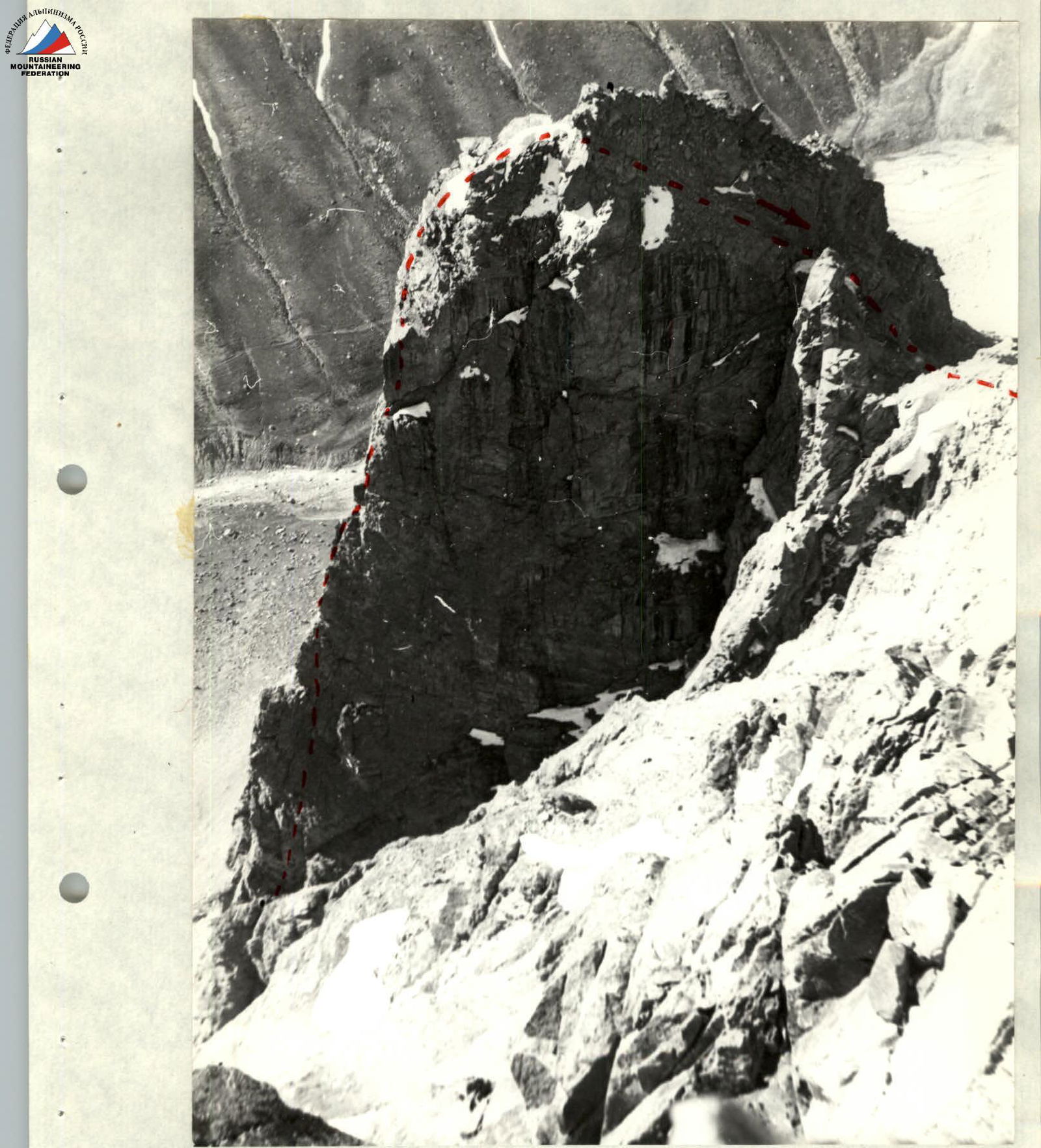
Further on, it's the same internal angle, only with more live stones, and at the exit from the angle, there are several ledges littered with stones. Climbing is relatively easy, but you need to be more careful. From here (R5–R6 section), on the right edge of the "pero" (top-right), a ledge is visible, the size of which allows for a tent to be set up. To get to it, you need to climb a steep, smooth slab and then move right along very destroyed rocks to reach the site.
We stand on the right edge of the "pero". The only way forward is straight up, a meter to the left of the edge. Climbing directly along the edge is impossible because it resembles the teeth of a saw standing on end, and to the left, there are again smooth overhangs.
On the site, we conduct a control tour and begin descending on hanging ropes. The processing is complete.
July 9. We start the route as a whole group. We quickly pass the section processed the day before and begin working further.
Ahead is the second half of the "pero", which is 10 degrees steeper than the lower part.
On the R8–R9 section, convenient cracks for chocks begin to appear, and although the steepness has increased, the tension is less. Another 40 m straight up, parallel to the edge, through sections of smooth walls and narrow cracks, leads directly to the edge of the ridge. From here, there are two possibilities:
- either bypass the next overhanging section on the left along a crack;
- or move right from the edge and exit upwards via an internal angle about 10 m long.
We choose the second option because suspicious live blocks are visible in the crack above on the left.
The internal angle (R10–R11 section) is a "book" opened at 90° with smooth pages. A well-placed chock helps to pass the upper part of the angle, from which a noticeable throw is made (obviously, a slight overhang). Immediately at the exit from the angle, there's a small site littered with freely lying stones, which roll down at the slightest load into the internal angle. It takes quite a lot of time to clear.
Further, along partially detached blocks, 20 m upwards and slightly to the left (R11–R12 section) to a crack cutting through the sheer wall, about 20 m long. This is one of the most beautiful places on the route, reminiscent of the best Alpine routes for V. Kavunenko, who has been to the Alps. To the left and right of the crack, smooth sheer walls drop away deeply, and only this crack makes it possible to climb free to the cornice.
Under the cornice, bypassing it on the right (difficult climbing) along a smooth, sheer wall, there's an exit to a small ledge where one person can stand. A belay point was made here. Another 20 m of tense climbing up a monolithic wall leads to a ledge, from which a flattening is already felt. Indeed, after 40 m of destroyed and steep, but no longer sheer, rocks, we reach the top of the "pero".
The key section of the route, 450 m long, has been passed, and although there are still about 500 m to the summit vertically, we consider the main problem solved.
The remaining part of the path to the summit goes along the southern ridge. The ridge is largely heavily destroyed, has several ups and downs, and can be generally assessed as category 4 difficulty.
It will soon be dark, and we, having passed two ropes along the jagged ridge of the "pero" and descended rappel into a gap, organize a bivouac. Here, for the first time since the start of the route, we found snow and water — the passed wall of the "pero" is absolutely dry.
July 10. From the night's bivouac in the gap, the ridge rises steeply. Despite a slight steepness of 40° to 50°, the destroyed rocks greatly slow down the movement. Individual blocks come loose at the slightest touch. This section (R17–R18) can be characterized as extremely destroyed.
After 200 m, the steepness of the ascent decreases, the ridge narrows, and gradually becomes almost horizontal, allowing for simultaneous movement (R18–R19 section). At the end of the R18–R19 section, the ridge abuts a fairly steep wall, which is bypassed on the right. To do this, you need to cross a wide couloir with ice and rock exits. After 10:00, stones periodically fall from above — so the pace of movement in the couloir is maximum (R19–R20 section).
Further, directly up the right side of the couloir and an exit to the crest on the right.
For 40 m, the ridge widens and gradually turns into a rocky, icy slope with a steepness of 40° to 60°, consisting of many cracks, walls, and boulders. The path here is ambiguous and is chosen directly towards the summit. At the end of the section, snow cover increases, and the exit to the summit ridge is already on snow. From here to the summit is another 100 m along the snowy ridge (with a cornice on the right!) and through the last rock outcrops, we ascend to the cairn.
You can descend from the summit in two ways:
- via the 4B category route to the Alaudin glacier (about 6 hours walking);
- into the Koksu valley via a couloir starting two ropes to the east of the summit. In the lower part of the couloir, two pinches are passed with rope retrieval. From the end of the couloir to the base camp is 30 minutes walking down the valley.
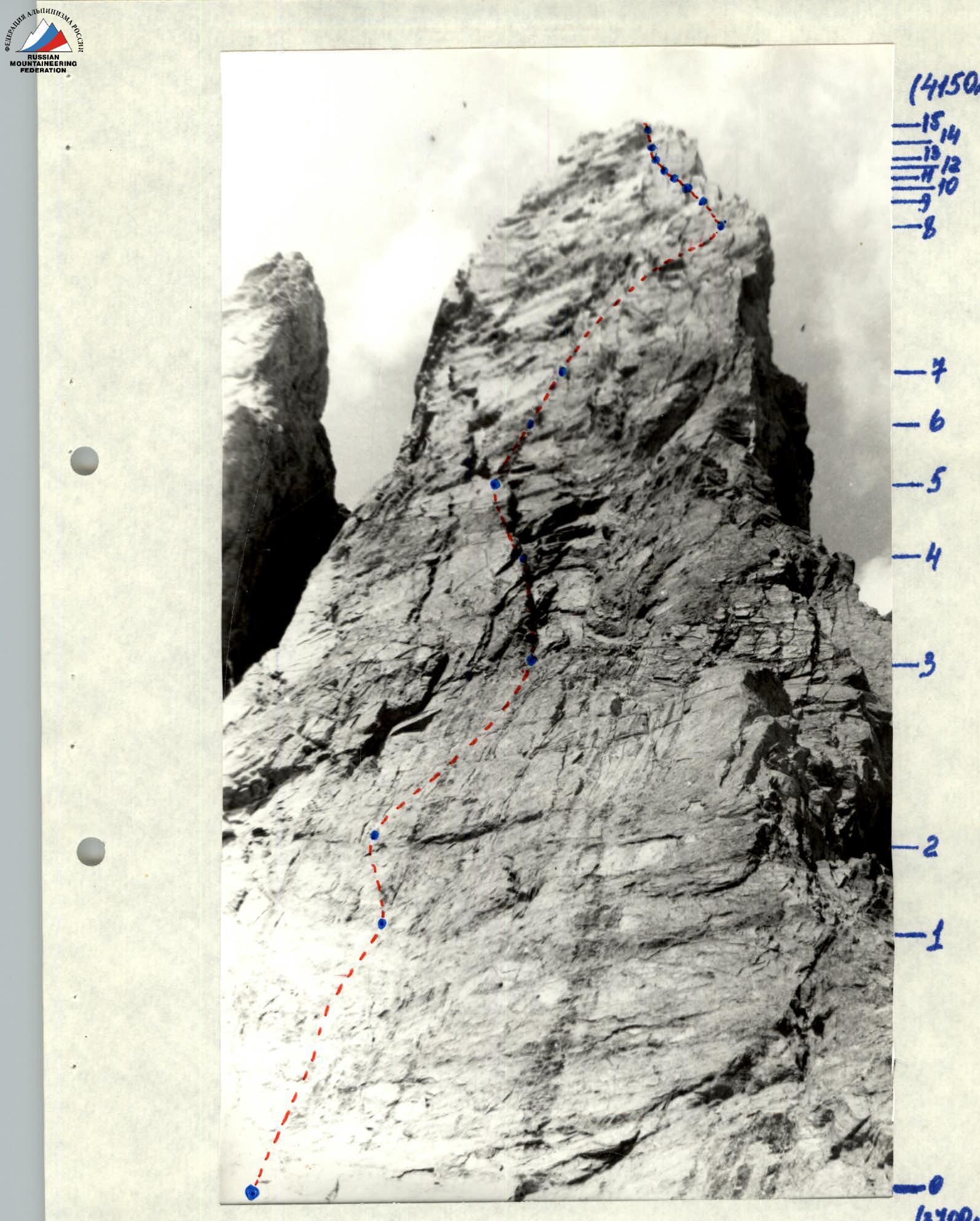
TABLE OF MAIN ROUTE CHARACTERISTICS
| Section | Length, m | Average steepness | Category of difficulty | Relief characteristics | Pitons for belay | Chocks for belay | Pitons for I.T.O. | Chocks for I.T.O. | Notes |
|---|---|---|---|---|---|---|---|---|---|
| R0–R1 | 50 | 70° | 4 | Monolithic. Few cracks for belay | 5 | 1 | 1 | - | July 8 |
| R1–R2 | 15 | 90° | 6 | Very few holds. Monolithic. Sheer | 2 | 1 | 1 | - | |
| R2–R3 | 40 | 65° | 4 | More diverse relief. Exit to a ledge | 3 | - | - | - | |
| R3–R4 | 30 | 75° | 4 | Internal angle. Live stones. Stemming | 4 | - | - | - | |
| R4–R5 | 30 | 70° | 4 | Internal angle. Live plugs | 3 | - | - | - | |
| R5–R6 | 20 | 60° | 5 | Very destroyed rocks | 2 | - | - | - | |
| R6–R7 | 15 | 85° | 6 | Monolithic slab | 1 | 2 | - | 1 | |
| R7–R8 | 50 | 70° | 5 | Approach to the control tour site | 4 | - | - | - | |
| R8–R9 | 60 | 75° | 4 | Wall with cracks. Edge on the right | 7 | 2 | - | - | July 9 |
| R9–R10 | 40 | 80° | 6 | Monolithic smooth wall | 3 | 3 | - | 1 | |
| R10–R11 | 8 | 90° | 6 | Internal angle "open book" | 1 | - | - | - | |
| R11–R12 | 20 | 75° | 4 | Destroyed rocks. Detaching blocks | 2 | - | - | - | |
| R12–R13 | 20 | 90° | 6 | Monolithic crack | 4 | - | - | 1 | |
| R13–R14 | 40 | 85° | 6 | Bypassing an overhang along a smooth wall | 5 | 2 | - | - | |
| R14–R15 | 40 | 65° | 4 | Destroyed rocks | 4 | - | - | - | |
| R15–R16 | 80 | 0° | 3 | Ridge of "pero" | - | - | - | - | 10 hours walking |
| R16–R17 | 80 | -70° | 3 | Descent into a gap | 2 | - | - | - | Night's bivouac on the site |
| R17–R18 | 180 | 50° | 5 | Extremely destroyed ridge | 5 | 2 | - | - | July 10 |
| R18–R19 | 100 | 20° | 2 | Rocky ridge | - | - | - | - | |
| R19–R20 | 90 | 40° | 5 | Crossing a snowy-icy couloir. Stones fall from above | - | 1 | - | - | |
| R20–R21 | 120 | 50° | 5 | Snowy-icy couloir | 3 | - | - | - | |
| R21–R22 | 200 | 55° | 5 | Ridge ascent. Short walls in places | 4 | 2 | - | - | |
| R22–R23 | 150 | 45° | 3 | Summit dome. Snowy rocks | 3 | 4 | - | - | |
| R23–R24 | 100 | 30° | 2 | Snowy ridge | 2 | - | - | - | 6 hours walking |
 |