
General View of the Summit
Route via the chimney of the South wall 5B. Route via the right edge of the chimney of the South wall 5B. Group route variation.
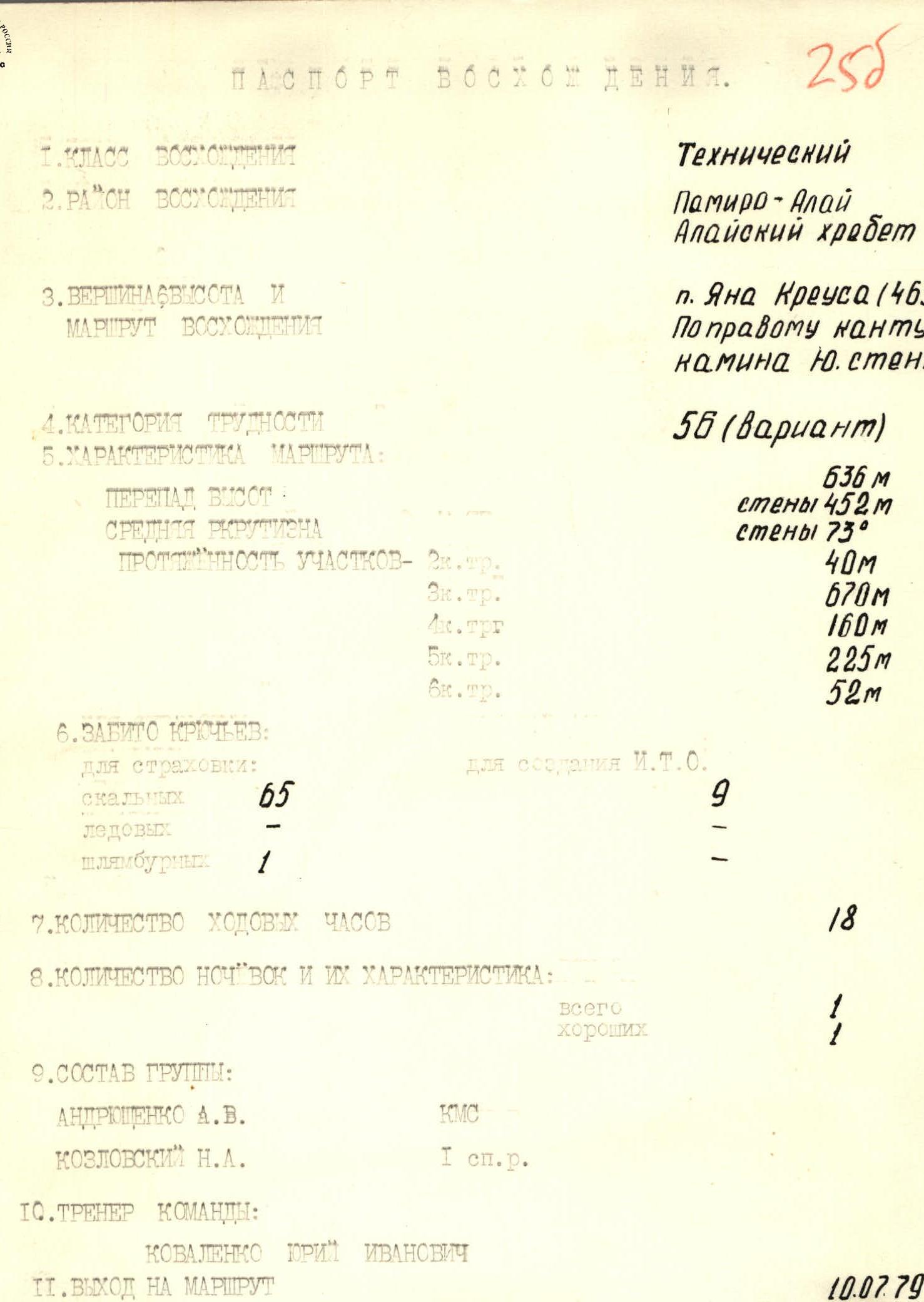
Climbing Passport
-
Climbing category — technical
-
Climbing area, ridge — Koksu gorge, Alay ridge
-
Peak, its height, climbing route — p. Jana Kreusa, 4634 m, via the center of the south wall.
-
Proposed category of difficulty — 5B (variant)
-
Route characteristics: a) height difference of the wall section — 550 m, height difference of the ridge section — 350 m. Total height difference — 636 m, wall height — 452 m. Average steepness of the wall section — 73°. b) length of sections: total length by category of difficulty (from passport 255): 2nd category — 40 m, 3rd category — 670 m, 4th category — 160 m, 5th category — 225 m, 6th category — 52 m; length by terrain type: ridge: 3rd category — 400 m, 4th category — 200 m; wall: 4th category — 130 m, 5th category — 450 m. c) average steepness of the wall section — 70°, average steepness of the ridge section — 40°.
-
Pitons hammered:
| Piton type | for belay | for creating I.T.O. |
|---|---|---|
| Rock | 83 (from passport 255: 65) | 3 (from passport 255: 9) |
| Bolt | – | – |
| Chocks | 8 | 1 |
- Number of climbing hours — 23 hours (from passport 255: 18 hours).
- Number of overnight stays and their characteristics — one overnight stay on a ridge (total 1, good 1).
- Full name of the leader, participants, and their qualifications:
- Khalitov Z.Sh. — CMS — leader
- Agishev R.G. — CMS — participant
- Vinokurov N.F. — CMS — participant
- Vorobiev A.S. — CMS — participant
- Moiseev O.M. — CMS — participant
- Mukanov K.B. — CMS — participant
- Pavlov V.F. — CMS — participant
- Polnov V.G. — MS — participant
- Andryushchenko A.V. — CMS — participant (from passport 255)
- Kozlovsky N.A. — 1st sports category — participant (from passport 255)
- Team coach — Honored Coach of Kaz.SSR Sedelnikov V.N. (from passport 255: Kovalenko Yuri Ivanovich)
- Date of departure on the route and return — August 7, 1981, 6:00 — August 8, 1981, 17:00 (from passport 255: July 10, 1979 – July 11, 1979)
Table of Main Route Characteristics
| Date | Designation | Average steepness | Length | Terrain characteristics | Difficulty | Condition | Weather conditions | Rock pitons | Ice pitons | Bolt pitons | Chocks |
|---|---|---|---|---|---|---|---|---|---|---|---|
| August 7, 1981 | R0–R1 | 60° | 10 m | Couloir turning into a chimney with a cork | 4 | Large blocks, then destroyed rocks | clear | 2 | – | – | – |
| R1–R2 | 70° | 25 m | Wall with a crack (left side of the couloir-chimney) | 5 | monolithic, smooth rocks | clear | 4 | – | 1 | – | |
| R2–R3 | 80° | 55 m | Wall. Exit to the edge | 5 | monolithic, smooth rocks, with few holds and cracks for pitons in the upper part | clear | 7 | – | 1 | – | |
| R3–R4 | 60° | 15 m | Edge of the wall | 4 | Rocks like "ram's foreheads" | “—” | 1 | – | – | – | |
| R4–R5 | 90° | 10 m | Inner corner; exit to a ledge for two | 5 | rocks with blocky character, partially destroyed | “—” | 3 | – | – | – | |
| R5–R6 | 90° | 10 m | Wall bypassing the cornice | 6 | monolithic rocks with micro-holds | “—” | 2 | – | – | – | |
| R6–R7 | 75° | 30 m | Wall and edge of the wall with small ledges | 5 | slightly destroyed rocks | “—” | 3 | – | – | 2 | |
| R7–R8 | 90° | 5 m | Traverse left along the wall, exit to a ledge to the "feathers" | 6 | monolithic rock with micro-holds | “—” | 2 | – | 1 | – | |
| R8–R9 | 90° | 5 m | Inner corner with a crack | 5 | monolith | “—” | 1 | – | 1 | 1 | |
| August 7, 1981 | R9–R10 | 75° | 15 m | Wall | 5 | smooth rocks | clear | 2 | – | – | – |
| R10–R11 | 70° | 6 m | Traverse right — down | 4 | rocks like "ram's foreheads" | “—” | 1 | – | – | – | |
| R11–R12 | 85° | 15 m | Wall | 5 | smooth rocks | “—” | 3 | – | – | – | |
| R12–R13 | 65° | 20 m | Right side of a huge inner corner | 5 | slab-like rocks with almost no holds | “—” | 5 | – | – | – | |
| R13–R14 | 70° | 30 m | Traverse right along a ledge, partially interrupted, with small walls | 4 | monolithic rocks | “—” | 3 | – | – | – | |
| R14–R15 | 95° | 7 m | Traverse right along the wall | 6 | monolithic rocks with micro-holds | “—” | 1 | – | 1 | – | |
| R15–R16 | 60° | 20 m | Exit to a balcony along a ledge | 3 | destroyed rocks | “—” | ledges | – | – | – | |
| R16–R17 | 95° | 10 m | Traverse right along the wall | 6 | monolithic, smooth rocks | “—” | 1 | – | 1 | 1 | |
| R17–R18 | 90° | 20 m | Wall with a 3-meter overhanging section | 6 | monolithic, smooth rocks like "ram's foreheads" | “—” | 2 | – | – | 2 | |
| R18–R19 | 70° | 10 m | Wall; exit to a ledge for 4 | 5 | monolithic rocks with good holds | “—” | 2 | – | – | – | |
| R19–R20 | 80° | 10 m | Wall with a wide crack | 5 | monolithic rocks | “—” | 1 | – | 1 | 1 | |
| R20–R21 | 60° | 30 m | Oblique chimney with a cork; exit to the main terrace | 5 | monolithic rocks with few holds | “—” | 3 | – | 1 | 1 | |
| R21–R22 | – | 40 m | Traverse right along the terrace | 2 | talus terrace | “—” | – | – | – | – | |
| August 7, 1981 | R22–R23 | 60° | 40 m | Wall with ledges and short steep sections; exit to the ridge | 4 | monolithic rocks with good holds | “—” | 4 | – | – | 3 |
| R23–R24 | 40° | 120 m | Ridge with small walls; exit to a notch | 3 | destroyed rocks | “—” | ledges | – | – | – | |
| R24–R25 | – | 18 m | Rappelling into a gap | – | – | “—” | 2 | – | – | – | |
| R25–R26 | 60° | 40 m | Small wall; exit to the ridge | 4 | destroyed rocks | “—” | 3 | – | – | ledges | |
| R26–R27 | – | 300 m | Ridge with a black-gray gendarme bypassed on the right and a double-peaked gray one bypassed on the left; exit to the summit tower | 3 | heavily destroyed rocks | “—” | 1 | – | – | ledges | |
| R27–R28 | 45° | 150 m | Wide ridge with talus ledges; exit to the snow dome of the forepeak | 3 | heavily destroyed rocks | “—” | 2 | – | – | ledges | |
| R28–R29 | 45° | 80 m | Snow slope; exit to the summit | 2 | slushy snow | “—” | – | – | – | – |
Explanation for the Table
From the base camp located in the Koksu gorge (geologists' camp), we departed on August 6, 1981, at 12:00. We reached the south wall of p. Jana Kreusa in 2 hours and set up camp on the left bank, at the confluence of the Koksu and Alaudin rivers.
We began observing the wall through binoculars. We identified a route via the center of the south wall, to the left of the existing routes via the chimney — 5B category, and the right edge of the chimney — 5B category.
On August 7, 1981, at 6:00, we started the route. The approach to the route goes along a large talus slope on the right side along the wall. The route begins at the start of the large talus slope (see id. photo 1).
The route starts directly up with rock ledges and difficult climbing with piton protection (section R0–R2). Then, 15 m to the right along an inclined ledge, we approach a rock wall. Up the wall, under the cornice (section R2–R3) (see id. photo 4). The cornice is traversed using ITO. Climbing is difficult. Next is an inner corner, 10 m, leading to a steep inclined slab (section R5–R6).
Along the slab, 20 m, we reach an inner corner. Up the corner to a ledge. On the ledge is a control cairn (section R7–R8). The ledge ends with a wall with a crack. Up the crack. The crack is traversed using chocks for ITO (section R8–R9). The crack leads to smooth slabs. To the right, up 40 m, to an inner corner, which leads to a destroyed ledge (section R10–R12) (see id. photo 5). Along the ledge to the right, 30 m, to an inner corner. Up the corner directly. The corner leads to a chimney. Be cautious, loose rocks (section R12–R14). The chimney leads to a not very steep destroyed inclined slab. From the slab, directly up, begins a steep chimney. The chimney is traversed using ITO. The chimney leads to a steep smooth slab (section R15–R17) (see id. photo 6). Along the slab to the left, 80 m, we approach the wall. The wall is traversed via a crack that goes from right to left and up (section R17–R19) (see id. photo 7).
Further, the wall becomes gentler and more destroyed. Along the destroyed rocks, we exit to the ridge. Overnight stay. At this point, the route converges with the previously climbed routes via the chimney — 5B category, and the right edge of the chimney — 5B category.
After the overnight stay, we continued along the ridge, 3rd and 4th category of difficulty, to the summit. Descent from the summit via couloirs into the Koksu gorge. The couloirs are prone to rockfall.
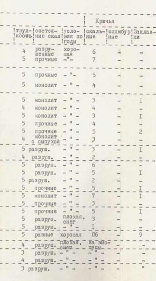
Table
| Date | Designation | Average steepness | Length (m) | Terrain characteristics | Difficulty | Rock condition | Weather conditions | Rock pitons | Bolt pitons | Chocks |
|---|---|---|---|---|---|---|---|---|---|---|
| August 7, 1981, 6:00 | R0–R1 | 60° | 40 | Rock ledges | 4 | destroyed | good | 6 | – | – |
| R1–R2 | 70° | 30 | Rock ledges | 5 | strong | – | 7 | – | – | |
| R2–R3 | 75° | 20 | Rock wall | 5 | strong | – | 5 | – | – | |
| R3–R4 | 100° | 3 | Cornice | 5 | monolith | – | 4 | – | – | |
| R4–R5 | 80° | 10 | Inner corner | 5 | monolith | – | 3 | – | 1 | |
| R5–R6 | 60° | 20 | Inclined slab | 4 | monolith | – | 4 | – | – | |
| R6–R7 | 90° | 15 | Inner corner | 5 | monolith | – | 3 | – | 1 | |
| R7–R8 | 70° | 25 | Ledge | 5 | strong | – | 4 | – | – | |
| R8–R9 | 90° | 45 | Rock wall with a crack | 5 | strong | – | 5 | – | 2 | |
| R9–R10 | 60° | 40 | Smooth slab | 4 | monolith with talus | – | 3 | – | – | |
| R10–R11 | 70° | 30 | Inner corner | 5 | destroyed | – | 3 | – | 1 | |
| R11–R12 | 40° | 30 | Ledge | 4 | destroyed | – | 2 | – | – | |
| R12–R13 | 60–40° | 40 | Inner corner | 5 | destroyed | – | 6 | – | 1 | |
| R13–R14 | 80° | 30 | Chimney | 5 | destroyed | – | 5 | – | – | |
| R14–R15 | 50° | 15 | Inclined slab | 5 | destroyed | – | 2 | – | 1 | |
| R15–R16 | 90° | 40 | Chimney | 5 | strong | – | 5 | – | – | |
| R16–R17 | 80° | 80 | Rock slab | 5 | monolith | – | 7 | – | – | |
| R17–R18 | 70° | 20 | Wall | 5 | strong | – | 3 | – | 1 | |
| R18–R19 | 90° | 40 | Wall | 5 | strong | – | 5 | – | – | |
| R19–R20 | 50° | 42 | Wall | 5 | destroyed, bad snow | – | 3 | – | – | |
| R20–R21 | 40° | 10 | Wall | 5 | destroyed | – | 1 | – | – | |
| Totals for the day | R0–R21 | 70° | 580 | Rock wall | 5 | different | good | 86 | – | 9 |
| August 8, 1981, 8:00 | R21–R22 | 40° | 100 | Rock ridge | 4 | destroyed, bad snow | overcast | 4 | – | 3 |
| R22–R23 | 40° | 200 | Rock ridge | 3 | destroyed | – | – | – | – | |
| R23–R24 | 40° | 100 | Rock-snow ridge | 4 | destroyed | – | – | – | – | |
| Reach the summit | R24–R25 | 40° | 200 | Rock-snow ridge | 3 | destroyed | – | – | – | – |