Ascent Log
- Type of ascent — rock climbing.
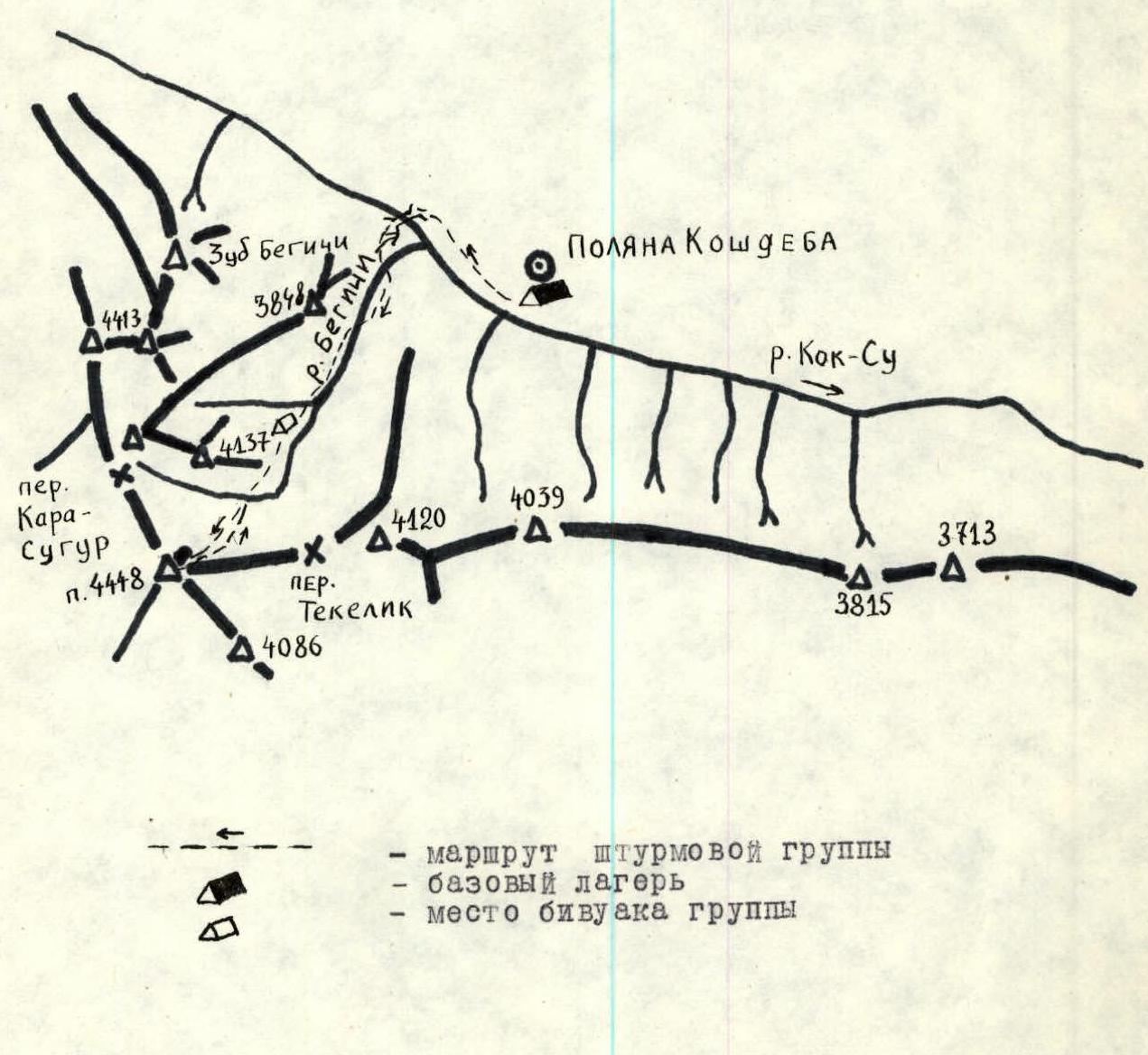
- Ascent area — Southern spurs of the Alay mountain range, Begichi gorge.
- Peak — 4448 m, via the eastern counterfort.
- Presumed category of difficulty — 4A.
- Route characteristics: height difference — 744 m, average steepness — 40°, total length of sections — 1180 m, 2nd category difficulty — 180 m, 3rd category difficulty — 620 m, 4th category difficulty — 180 m.
- Pitons hammered: for rock belay — 21.
- Total travel time — 9 hours.
- Group composition: leader — Chernyaev A.I., 1st sports category, members — Engalycheva R.I., CMS, Zemlyanov M.E., 1st sports category, Kudryashov V.S., 1st sports category.
- Team coach — Kudryashov V.S.
- Departure to the route — August 15, 1977 at 7:00. Return — August 15, 1977 at 16:00.
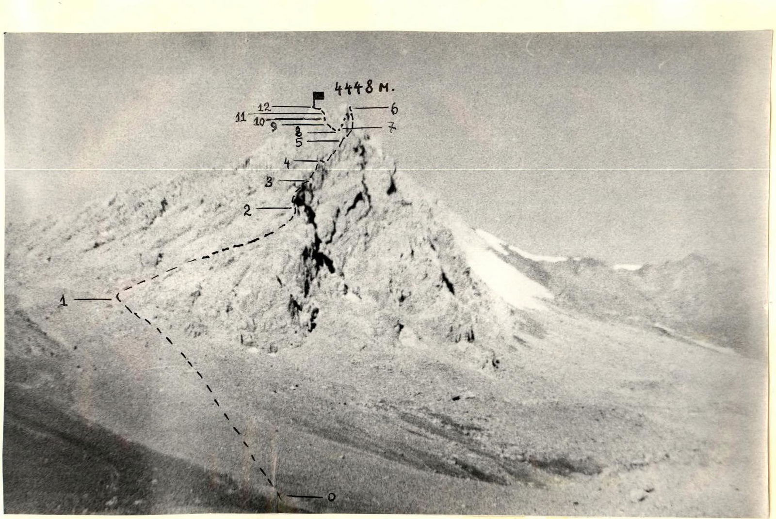
General view photo of the peak.
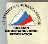
Route profile photo.
Ascent Area Map
Appendix № 2
| Section | Steepness | Length | Section characteristics | Number of pitches / category of difficulty | Belay characteristics | Pitons1 | Pitons2 | Pitons3 | Pitons4 | Pitons5 | Pitons6 | Pitons7 | Pitons8 | Pitons9 | Pitons10 | Pitons11 |
|---|---|---|---|---|---|---|---|---|---|---|---|---|---|---|---|---|
| R0–R1 | 35° | 200 | grass, scree | 1 | good | — | — | — | — | — | — | — | — | — | — | — |
| R1–R2 | 35° | 140 | rocks | 2 | monolithic | — | — | 2 | — | — | — | — | — | — | — | — |
| R2–R3 | 35° | 140 | rocks | 3 | destroyed | — | — | — | — | — | — | — | — | — | — | — |
| R3–R4 | 75° | 40 | rocks | 4 | monolithic | — | — | — | 6 | — | — | — | — | — | — | — |
| R4–R5 | 50° | 50 | rocks | 3 | destroyed | — | — | — | — | — | — | — | — | — | — | — |
| R5–R6 | 10° | 40 | rocks | 2 | destroyed | — | — | — | — | — | — | — | — | — | — | — |
| R6–R7 | 50° | 50 | rocks | 3 | — | — | — | — | — | — | 3 | — | — | — | — | — |
| R7–R8 | 45° | 180 | rocks | 3 | — | — | — | — | — | — | — | — | — | — | — | — |
| R8–R9 | 60° | 120 | rocks | 4 | monolithic | — | — | — | — | — | — | — | 8 | — | — | — |
| R9–R10 | 30° | 100 | rocks | 3 | destroyed | — | — | — | — | — | — | — | — | — | — | — |
| R10–R11 | 50° | 20 | rocks | 4 | — | — | — | — | — | — | — | — | — | — | 2 | — |
| R11–R12 | 30° | 100 | rocks | 3 | — | — | — | — | — | — | — | — | — | — | — | — |
Brief Description of the Approach to the Route
The base camp is located in the Kok-Su gorge on the Kosjdeba clearing. From the base camp, go upstream along the Kok-Su river on the left bank. Then, through the first bridge, the trail leads to the Begichi gorge. The trail mainly follows the left bank of the river flowing from the Begichi gorge.
Crossing the "koshey" clearing, we come to the confluence of two rivers. From this point, the 4448 m peak closing the Begichi gorge is clearly visible. This is a suitable spot for a bivouac. It takes 3.5 hours to reach this point from the base camp.
Brief Explanation of the Table (Appendix № 2)
Section R0–R1. From the bivouac, approach the start of the route through grass, then scree, to the 1st snow patch, bypassing the lower part of the eastern counterfort on the left.
Section R1–R2. A ledge leads up to the right, turning into a wide chimney with a huge plug. First, follow the ledge, then bypass the rock ridge on the left to reach the crest of the eastern counterfort. Above the exit point to the crest, on the ledge, we build 1 control cairn.
Section R2–R3. Then, bypassing the destroyed wall on the left through the slabs, we approach a black smooth slab. The slab is bypassed on the left through a couloir. Along the crest, we approach the wall of a reddish pointed gendarme.
Section R3–R4. The wall is climbed directly, climbing is difficult, belay is via pitons. The top of the gendarme is bypassed on the left through a wall.
Section R4–R5. We approach the wall of a large gendarme. The wall is destroyed, its lower part (3 m) is vertical, climbing is difficult. The rest of the wall is climbed through the center, climbing is moderately difficult. Many "live" stones!
Section R5–R8. Then, descend into a gap and ascend along the crest, bypassing gendarmes on the left, to a large internal angle. The internal angle leads to a small snow patch, crossing which, we come under a black wall of large-block structure.
Section R8–R9. The wall is climbed on the right part, closer to the crest, climbing is difficult, belay is via pitons.
Section R9–R10. Then, along the crest, bypassing gendarmes on the left, we come to a spur that leads to the pre-summit crest.
Section R10–R12. Through a wall with piton belay, we exit onto the crest (the crest is sharp). Along the crest, we ascend to the summit.
The descent from the summit is to the south along a heavily destroyed crest, bypassing a large gendarme on the right through scree ledges. Then, through a gap to the left onto "ram's foreheads", along which we descend to scree slopes leading to the start of the route. The descent took 2 hours.
The group assesses the difficulty of the route as 4A category. In a preliminary conversation with local residents, the group found that this peak has no name. By the right of the first ascenders and in honor of Tatar oil workers extracting 1.5 billion tons of oil, we propose to name this peak "Neftyanikov Tatarii" (Oil Workers of Tatarstan). Kara-Suguur