PASSPORT
ASCENT TO Mt. Zub Begichi (4100 m) via the NE counterfort.
- Class of ascent — technical.
- Area of ascent — Southern spurs of the Alayskiy ridge, Kok-Su valley.
- Peak 4100 m, proposed name Zub Begichi.
- Proposed category of difficulty 4B.
- Route characteristics:
- height difference – 1100 m, length of sections:
- 5th difficulty category – 120 m
- 4th difficulty category – 260 m
- 3rd difficulty category – 370 m
- Average steepness – 45°.
- height difference – 1100 m, length of sections:
- Number of pitons hammered for belay – 23.
- Number of travelling hours – 15.
- Number of overnight stays – none.
- Group composition:
- Solovyov B.M. – 1st sports category
- Golenetskiy S.V. – 1st sports category
- Coach: Korkin I.V. – Master of Sports.
- Date of departure and ascent – August 9, 1977.

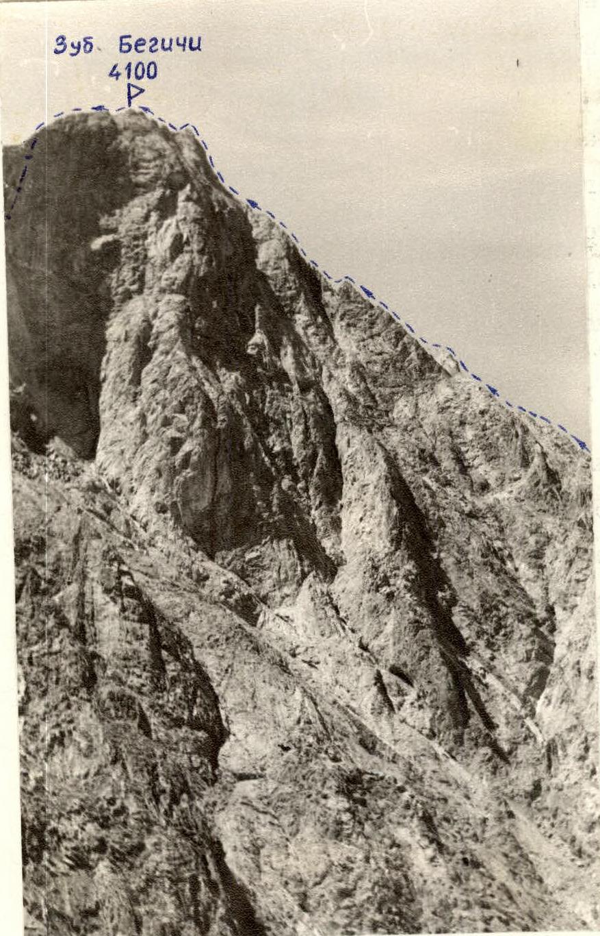
Photo 3. Profile of the north-eastern counterfort of Mt. Zub Begichi (4100 m).
 www.alpfederation.ru↗
DESCRIPTION
Route of ascent to Mt. Zub Begichi (4100 m) via the NE counterfort 4B category of difficulty (second traverse of the route).
From the camp located at Kozhdeba clearing, walk up the road to the bridge. Cross the bridge to the right (orographic) bank of the Kok-Su River and follow the trail to the clearing opposite the crashed helicopter (45–50 min walk).
From the far corner of the clearing, ascend via scree slopes to the left of the rock wall – towards the start of the couloir. Ascend the couloir along the eastern walls of the NW ridge of the peak – to the foot of the NE wall (1.5–2 hours).
From here, ascend leftwards up rocks of medium difficulty and a 20–30 m wall – to reach the NE counterfort. Follow the sharp ridge of the counterfort (loose rocks in places!) – to below the base of the ascent (60–80 m). The exit to the ascent is made on the right via smooth slabs (pitons used for belay, 160 m).
Further on, the counterfort becomes more gentle. Simultaneous movement with belay via ledges (80 m).
The pre-summit ascent of the counterfort (extending 200 m) is: — a rib weakly protruding from the wall and leading below the summit pinnacle; — at this point, the counterfort connects with the NW ridge; — ascended directly, partly via ledges on the right (pitons used for belay – key section of the route).
Descent from the summit is made eastwards along a steep narrow degraded ridge (80–90 m) to a dark-brown couloir (on the right as you descend).
— Descent into the couloir is 20 m (rappel). — Follow the couloir (80–100 m) to reach scree, and then herb slopes. — Cross the NE cirque of peak 4473 m eastwards, to reach the herb slopes of the NE ridge of peak 3800 m. — Ascend the grassy col (10 min). — From the col, descend via grass to the trail.
Total descent time is 3–4 hours.
The second traverse of the route was made by a group consisting of:
— Solovyov B.M. – 1st sports category — Golenetskiy S.V. – 1st sports category
