
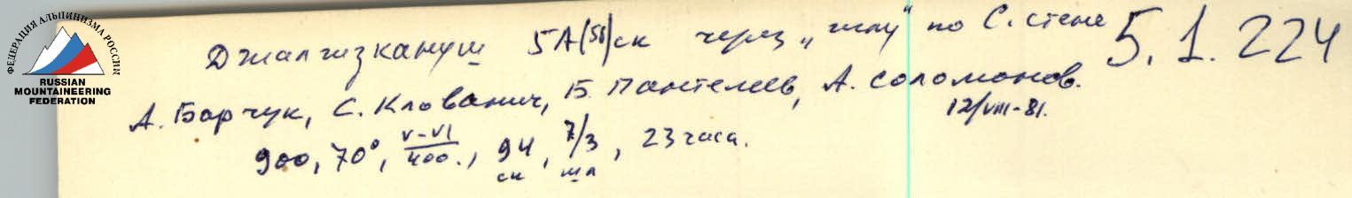
Ascent Passport
- Ascent class — technical
- Ascent area — Pamir-Alay, Koksu gorge, Alay ridge
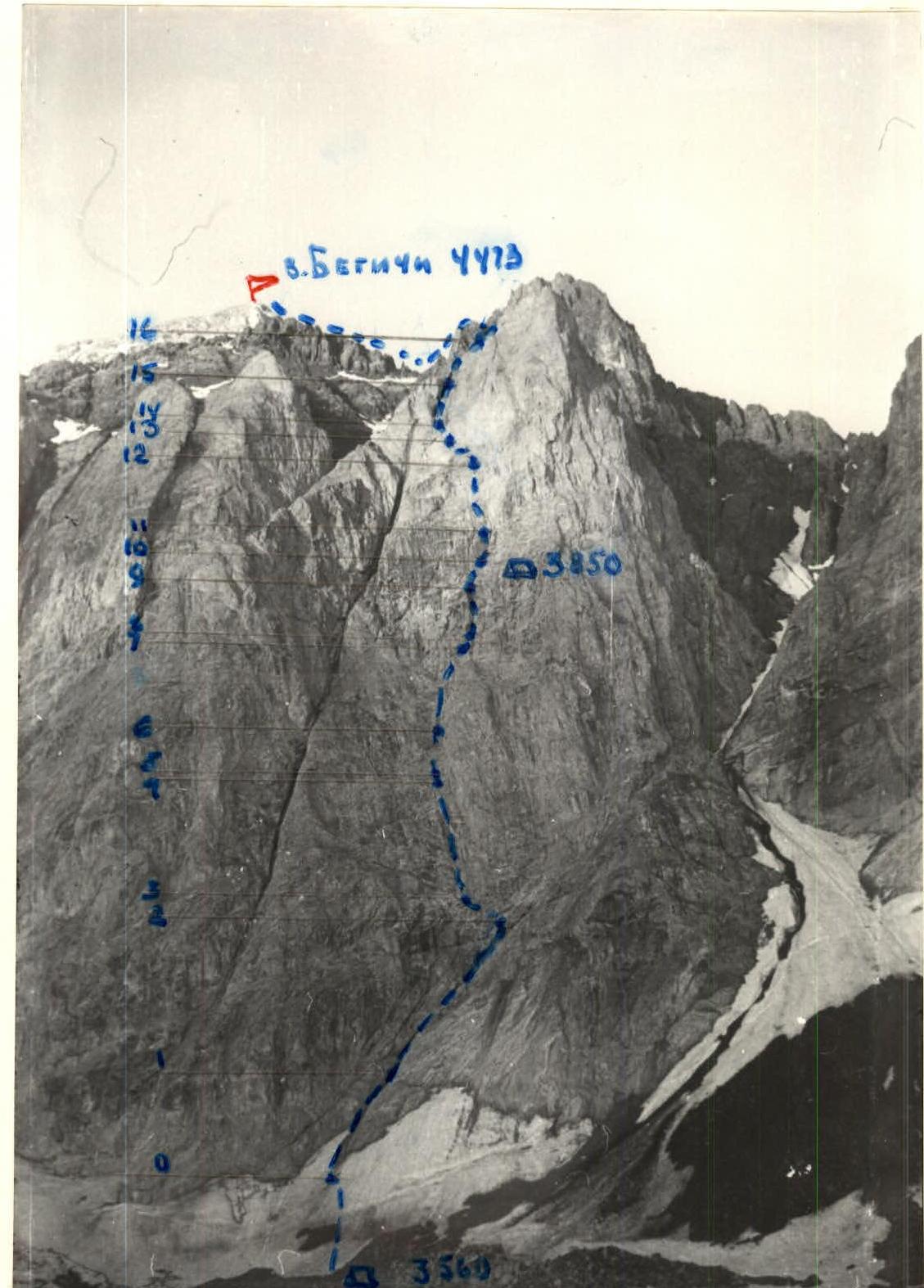
- Peak, its height, ascent route — Begichi, 4473 m, via "Igla" on the North wall
- Proposed difficulty category — 5B
- Route characteristics: height difference — 900 m, length of sections 5–6 cat. dif. — 400 m, average steepness of the wall section — 70°
- Pitons hammered for insurance: rock — 94 pcs., bolted — 3 pcs.; for creating artificial anchor points — 4 rock pitons
- Number of travel hours — 23 hours
- Number of overnight stays — one seated, for the whole group
- Team composition:
Team leader Barchuk A.N. — Candidate Master of Sports, Panteleev B.L. — Candidate Master of Sports, Solomonov A.I. — Candidate Master of Sports, Klovanich S.F. — 1st sports category
- Team coach Solomonov A.I.
- Date of departure on the route August 11, 1981, date of return August 12, 1981
Route Profile
August 11, 1981. Departure at 7:00, stop for bivouac at 19:30, travel hours 13. Overnight stay seated, no water. Rain at night, clear during the day. August 12, 1981. Departure at 8:00, travel hours 10.
TABLE of main characteristics of the ascent route
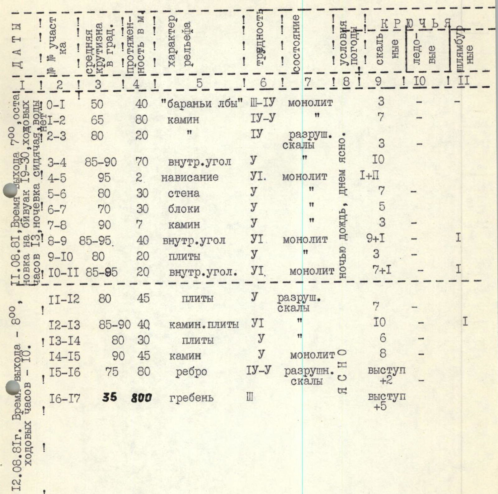
| Section № | Steepness, ° | Length, m | Terrain character | Cat. dif. of section | Condition | Rock pitons, pcs. | Bolted pitons, pcs. |
|---|---|---|---|---|---|---|---|
| R0–R1 | 50 | 40 | "ram's foreheads" | 3–4 | monolith | 3 | -- |
| R1–R2 | 65 | 80 | chimney | 4–5 | monolith | 7 | -- |
| R2–R3 | 80 | 20 | 4 | broken rocks | 3 | -- | |
| R3–R4 | 85–90 | 70 | inner corner | 5 | broken rocks | 10 | -- |
| R4–R5 | 95 | 2 | overhang | 6 | monolith | 11+1 | -- |
| R5–R6 | 80 | 30 | wall | 5 | monolith | 7 | -- |
| R6–R7 | 70 | 30 | blocks | 5 | monolith | 5 | -- |
| R7–R8 | 90 | 7 | chimney | 5 | monolith | 3 | -- |
| R8–R9 | 85–95 | 40 | inner corner | 6 | monolith | 9+1 | 1 |
| R9–R10 | 80 | 20 | slabs | 5 | monolith | 3 | -- |
| R10–R11 | 85–95 | 20 | inner corner | 6 | monolith | 7+1 | 1 |
| R11–R12 | 80 | 45 | slabs | 5 | broken rocks | 7 | -- |
| R12–R13 | 85–90 | 40 | chimney, slabs | 6 | monolith | 10 | 1 |
| R13–R14 | 80 | 30 | slabs | 5 | monolith | 6 | -- |
| R14–R15 | 90 | 45 | chimney | 5 | monolith | 8 | -- |
| R15–R16 | 75 | 80 | ridge | 4–5 | broken rocks | ledge +2 | -- |
| R16–R17 | 35 | 800 | ridge | 3 | ledge +5 | -- |
Brief explanation of the table
The route starts to the right of the main chimney crossing the "Igla" wall. From the snowfield, left — up along the ledge under the inner corner of the chimney, going to the right of the main chimney from left to right.
- Rocks, like "ram's foreheads", 40 m (section R0–R1).
- Further along the right edge of the chimney to the right — up 80 m, monolithic rocks (R1–R2).
- Traverse left 20 m under a vaguely expressed corner, rocks are broken (R2–R3).
- Up a system of inner corners 70 m under an overhang. The first one goes in galoshes, steepness 85–90° (R3–R4).
- The 2 m overhang is passed using artificial anchor points along the left part of the inner corner (R4–R5).
- After the overhang, straight up the wall 30 m, monolithic rocks with a limited number of holds (R5–R6).
- Then to the right — up in the direction of the overhanging "nose" ("nose" is visible from the bivouac in the middle of the wall) along large monolithic blocks 30 m. A seated overnight stay is possible (R6–R7).
- Straight — up the chimney (7 m), steepness 90°, exit under the "nose" to the right. Rocks are monolithic (R7–R8).
- The "nose" is bypassed to the right along the right wall of the inner corner, like a "book", 40 m, using artificial anchor points. On top of the "nose" — a seated overnight stay for four people. At the overnight stay, there is a bolted piton, control cairn №1 (R8–R9).
- From the bolted piton to the right — up, along smoothed slabs 20 m to the inner corner, rocks are monolithic (R9–R10).
- Along the inner corner to the left — up 20 m, the overhang is passed using artificial anchor points. Exit onto slabs (bolted piton) (R10–R11).
- From the bolted piton, traverse left 5 m along smoothed slabs and then left — up to a small ledge under the overhang 40 m. A seated overnight stay is possible (R11–R12).
- From the ledge up 40 m along the inner corner and vertical slab with a limited number of holds, bolted piton (R12–R13).
- From the bolted piton up along broken slabs (loose rocks) to the overhanging chimney (R13–R14).
- Up the chimney to the exit onto the "Igla" ridge, rocks are monolithic (R14–R15).
- Along the ridge 80 m up to control cairn №2, which is installed on the "Igla" shoulder (R15–R16).
- Further along the ridge of the third category of difficulty, exit to the Begichi summit (2 hours 30 minutes – 3 hours) (R16–R17).
Descent from the summit to the east along the route 2B cat. dif.