ASCENT DOCUMENT.
- Ascent type: traverse.
- Ascent area: Southern spurs of the Alaysky ridge, Kок-Су gorge.
- Traverse of unnamed peaks "D" 4850 m - "P" 4840 m - "T" 4950 m.
- Estimated difficulty category: 4A.
- Route characteristics:
- height difference:
- section lengths:
- no category - none
- 1st category - 480 m
- 1st category - 970 m
- 1st category - 300 m
- total route length - 1880 m
- average steepness - 45°
- Pitons used for belaying:
- rock pitons - 12
- ice pitons - none
- Total climbing hours - 9 (excluding approaches)
- Number of bivouacs and their characteristics - none.
- Leader:
- NEPLOKHOV ANDREY DMITRIEVICH – 2nd sports category
- Team members:
- ROMANOV EVGENY VASIL'EVICH – 2nd sports category
- MELIKHOV ALEKSANDR PETROVICH – 2nd sports category
- KASATKIN GENNADY EVSTAF'EVICH – 2nd sports category
- KARAZEEV ALEKSANDR NIKOLAEVICH – 2nd sports category
- EKIMOV SERGEY MIKHAILOVICH – Master of Sports
- ALEKSEEV ANATOLY VLADIMIROVICH – 2nd sports category
- NOVGORODTSEVA GALINA PETROVNA – Master of Sports
- Team coaches:
- NOVGORODTSEVA G.P. – Master of Sports
- EKIMOV S.M. – Master of Sports
- Departure date from the camp - July 14, 1978. Return to the camp - July 15, 1978.
Brief explanation for the table of main characteristics.
From the "Kozhdoba" clearing of the "Alay" alpine camp along the left (orographic) bank of the Koshka-Su river to the green clearing in the cirque of the peak Synovey. Bivouac on the clearing (2.5-4 hours).
R0–R1. Approach to the route from the bivouac up the moraine to a wide scree couloir with snow in the upper part.
R1–R2. Ascent up the couloir to the ridge col.
R2–R3. Bypass a gendarme on small walls to the left and up, with an exit to scree and heavily destroyed ledges.
R3–R4. Along ledges to the pre-summit gendarme. Ascent to the gendarme on heavily destroyed rocks composed of large blocks. Descent from the gendarme to the col.
R4–R5. From the col, ascent through a chimney (20 m) and a wall (20 m) to the summit "D".
R5–R6. From the summit "D" descend to the col through the first gendarme. From the col, descend to the left, bypassing the 2nd and 3rd gendarmes, then back to the col and ascent to the 4th large gendarme - bypass to the left. The 5th gendarme is bypassed to the right and descent through a narrow 8 m chimney. Then pass the 6th and 7th gendarmes head-on. After the 7th gendarme, descend to the col under the summit "P".
R6–R7. From the col, ascend the wall and reach the summit "P".
R7–R8. Descend from the summit "P" to a snowy col.
R8–R9. To the right of the ridge, starting from the summit "P", the ridge is snowy, steep, and hazardous for descent. There is ice under the snow. Move along the edge of snow and rocks, bypassing four gendarmes to the right, under the pre-summit wall of peak "T".
R9–R10. Ascent up a steep ridge and wall to the summit "T".
R10–R11. Descend from the summit "T" via the ascent route.
R11–R12. Continue to the col under the summit "P".
R12–R13. From the col, descend a steep, rocky, and heavily destroyed couloir, exiting into a snowy couloir, and descend through the snow to the glacial moraine.
R13–R14. Return along the glacial moraine to the original bivouac.
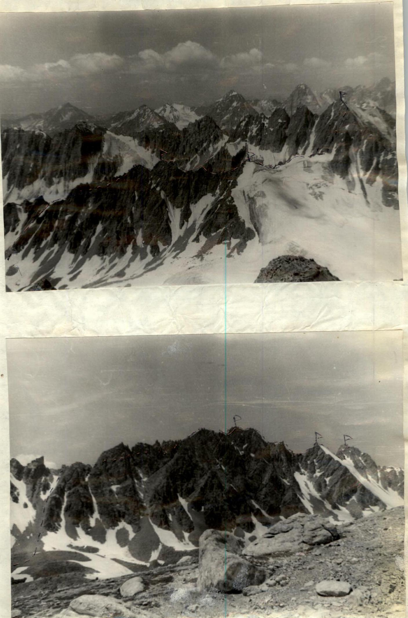
TABLE OF MAIN ROUTE CHARACTERISTICS.
| Date | Designation | Average steepness (degrees) | Length (m) | Terrain characteristics | Difficulty | Condition | Weather conditions | Rock pitons | Ice pitons | Bolts | Time of departure and stop, climbing hours |
|---|---|---|---|---|---|---|---|---|---|---|---|
| R0–R1 | 0 | Approach | 1 hour | ||||||||
| R1–R2 | 45 | 120 | Couloir | Clear | 50 min | ||||||
| R2–R3 | 60 | 50 | Rocky walls | 2 | Destroyed rocks | 2 | – | 30 min | |||
| R3–R4 | 35 | 300 | Ledges | 2 | Heavily destroyed rocks | 1 | – | 1 hour | |||
| R4–R5 | 70 | 20 | Rock | 2 | Destroyed rocks | 1 | 40 min | ||||
| 20 | Wall | 2 | |||||||||
| R5–R6 | 35 | 360 | Ridge with gendarmes | 2 | 1 | 1 hour | |||||
| 14.07.1978 | R6–R7 | 70 | 80 | Wall | 4 | Monolith | 2 | 50 min | |||
| R7–R8 | 50 | 120 | Ridge | 2 | Destroyed rocks | 20 min | |||||
| R8–R9 | 30 | 120 | Ridge | 2 | Destroyed rocks and snow with ice base | – | 30 min | ||||
| R9–R10 | 75 | 200 | Steep ridge, rock | 4 | Monolith | 3 | 1 hour | ||||
| R10–R11 | 75 | 200 | 4 | 40 min | |||||||
| R11–R12 | 30 | 120 | Ridge | 2 | Same as R8–R9 | – | 30 min | ||||
| R12–R13 | 65 | 160 | Couloir | 2 | Heavily destroyed rocks and snow | 1 | 50 min | ||||
| R13–R14 | – | 2000 | Glacial moraine | – | 1 hour |
Departure from "Alay" alpine camp at 5:00. Return to the bivouac on the green clearing at 20:30.