- Climbing category — technical.
- Climbing area — Alai Range, Koksu valley.
- Summit — Peak "G", 4850 m, via the north-eastern counterfort.
- Difficulty category — 3B.
- Route characteristics: elevation gain — 360 m, length — 470 m, average steepness — 50°
- Pitons hammered for belay: rock pitons — 24
- Total climbing hours — 4.
- Overnight stays — none.
- Group composition: SITNIK M.A., 1st sports category, instructor (leader) OLIK A.P., 1st sports category, instructor ROMANENKO A.S., 1st sports category, instructor FENOV A.A., 1st sports category POZNYAKOV V.O., 1st sports category.
- Group coach — Master of Sports POPOV A.V.
- Date of departure — July 22, 1979. Date of return — July 22, 1979.
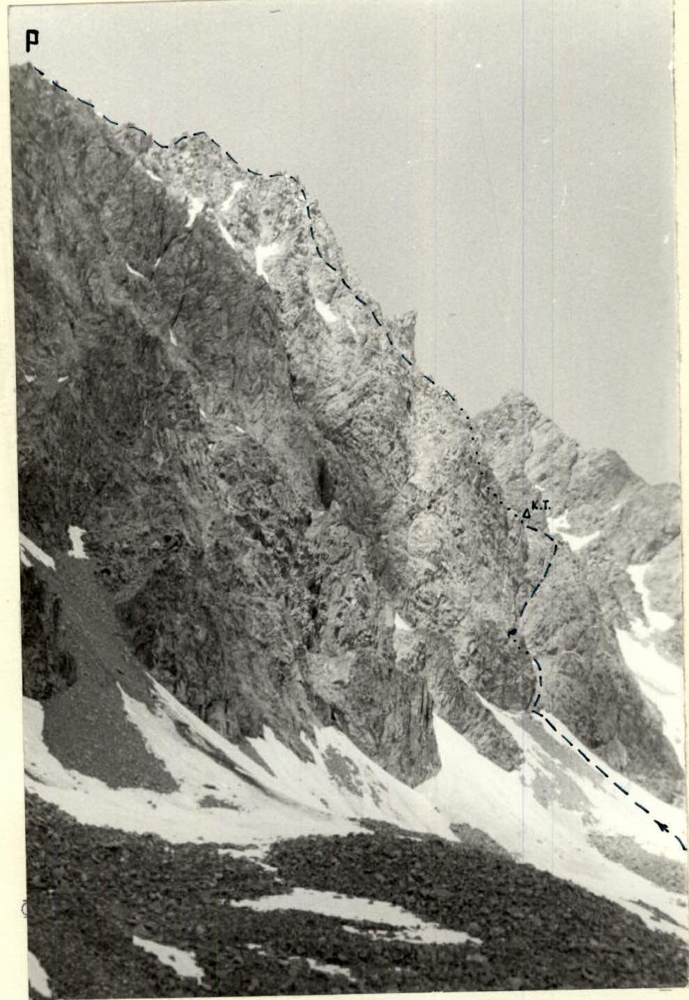
Photo 1. Side view of the route.
| Section | Steepness, ° | Length, m | Section difficulty category | Terrain type | Section condition | Weather conditions | Number of pitons | Notes |
|---|---|---|---|---|---|---|---|---|
| R0–R1 | 30 | 60 | couloir | dense snow | good | - | ||
| R1–R2 | 60 | 15 | 3 | inner corner | monolith | good | 1 | |
| R2–R3 | 30 | 20 | 2 | hollow | broken rocks | good | outcrops | rockfall hazard! |
| R3–R4 | 70 | 80 | 3 | inner corner | solid rocks | good | 5 | |
| R4–R5 | 20 | 20 | 2 | ledge | solid rocks | good | outcrops | control point |
| R5–R6 | 45 | 40 | 3 | ridge | broken rocks | satisfactory | 2 | |
| R6–R7 | 70 | 30 | 3 | ridge | broken rocks | satisfactory | 3 | |
| R7–R8 | 20 | 30 | 2 | ridge | broken rocks | satisfactory | outcrops | |
| R8–R9 | 45 | 60 | 3 | ridge | solid rocks | satisfactory | 3 | |
| R9–R10 | 80 | 60 | 4 | wall | solid rocks | satisfactory | 8 | key location |
| R10–R11 | 30 | 20 | 3 | ridge | broken rocks | satisfactory | 2 | |
| R11–R12 | 30 | 30 | 2 | shoulder | solid rocks | satisfactory | outcrops |
Table 1. Characteristics of sections on the 3B category route to Peak "G" via the north-eastern counterfort. The approach path to the summit is shown in Fig. 1.
Approach to the Summit
The path to the summit is shown in Fig. 1.
- From the Koshdeba clearing, follow the left (orographically) bank of the Koshka-su River (the canyon is bypassed via a trail on the slope) to the waterfall – 1.5–2 hours.
- From the waterfall, ascend for 0.5 hours, cross the river via boulders, then follow the moraines to the cirque of Peak Sons.
- Move in the direction of Peak Tereshkova to the overnight stay near Peak Sons.
- From there, move left along the moraines under the slopes of Peak "G" – 1 hour.
- Overnight stay under Peak "G" on the moraine near the lake.
The total approach time is 3–3.5 hours.
Brief Explanation of the Table
The route follows the north-eastern counterfort of Peak "G". The counterfort is bounded on the right by a snow-ice couloir starting under the sub-summit of Peak "G", and on the left by a snow-scree couloir. The right couloir is prone to rockfall and possible avalanches; the upper part of the couloir has ice with a steepness of up to 70°. The path through the couloir is complex and objectively hazardous. The left couloir starts from the middle of the wall, is prone to rockfall, and the rocks above the couloir are difficult to traverse. Thus, the counterfort is the most logical and safe shortest path from the north-east to Peak "G".
The rocks of the counterfort, despite their apparent fragility, are very solid. The route features sharp, solid, and convenient holds that facilitate the passage of steep sections. The numerous cracks and fissures allow for reliable belays using pitons or chocks almost anywhere.
The route begins with an ascent through the snow in the left couloir to a clearly visible inner corner in the right wall of the couloir. Ascend the right (inclined) wall of the inner corner to a hollow, then under an 80 m steep wall, which is traversed via an inclined inner corner crossing the wall from the center to the right. The corner leads to a ledge, then left onto a broken ridge. Control point.
Along the ridge, with varying steepness (including short vertical sections), ascend 150–200 m to the sub-summit wall – the key location of the route. The wall is traversed:
- via a 3 m chimney upwards
- then traverse left for 10 m along slabs to an inner corner
- ascend the inner corner for 8–10 m under a 20-meter wall, which leads to a broken ridge.
Follow the ridge to the right shoulder of the summit (Caution! The rocks are heavily broken), then to the summit.
The descent from the summit is along its right shoulder, then via a couloir (with some sections having flow ice) to the cirque of Peak Rescuers (1 hour). The descent is straightforward and safe.
Leader M. Sitnik