Ascent Log
I. Ascent category: technical
-
Ascent area: Pamir-Alay, Alay Ridge
-
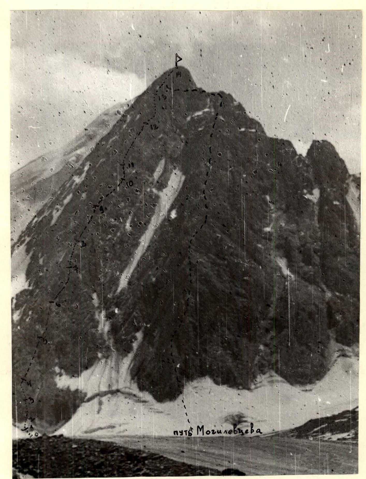
Peak, its height, ascent route: Shait, 4916 m, via the NE wall on Matovcharov's path (official route)
-
Proposed difficulty category: 5B category
-
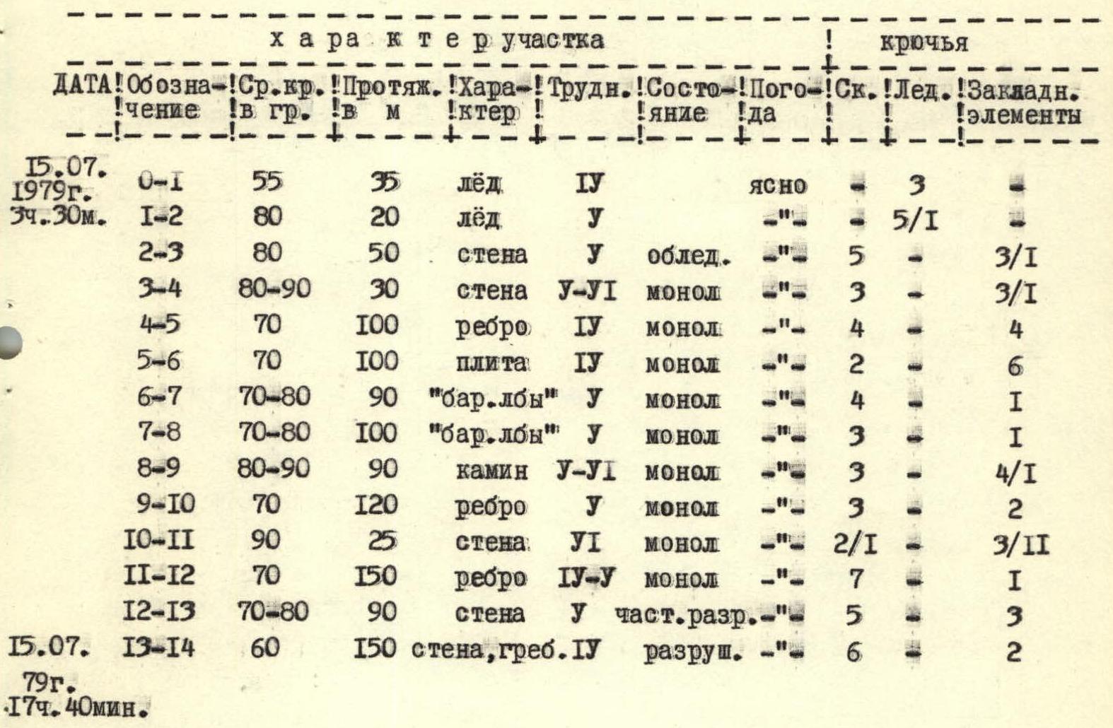
Route characteristics: Height difference 900 m Average slope 65°. Section lengths:
- Steep terrain — 535 m
- Steep terrain — 560 m
- Steep terrain — 65 m
- Pitons driven:
| For belay | For creating intermediate belays | |
|---|---|---|
| Rock | 47 | 1 |
| Ice | 8 | 1 |
| Chocks | 33 | 5 |
-
Total climbing hours: 14 hours
-
Number of bivouacs and their characteristics: no bivouacs
-
Surname, name, patronymic of the leader, participants, their sports qualification:
- Kurmachov Yuri Fedorovich — CMS
- Sereda Vladimir Alexandrovich — CMS
Observation group:
- Sapozhnikov O.G. — CMS
- Laptenok V.D. — CMS
-
Team coach: Yakovlev Vitaly Dmitrievich — senior instructor, Master of Sports of the USSR
-
Date of departure and return: 1979 July 15, 3:30 — departure, July 15, 22:00 — return.
Main Route Characteristics Table
 Mogilevcev's path
| Date | Section | Average slope in degrees | Length in meters | Terrain | Difficulty | Condition | Weather | Rock pitons | Ice pitons | Chocks |
|---|---|---|---|---|---|---|---|---|---|---|
| 15.07.1979 3:30 | R0–R1 | 55 | 35 m | ice | IV | Clear | – | 3 | – | |
| R1–R2 | 80 | 20 m | ice | V | – | – | 5/1 | – | ||
| R2–R3 | 80 | 50 m | wall | V | icy | – | 5 | – | 3/1 | |
| R3–R4 | 80–90° | 30 m | wall | V–VI | monolithic | – | 3 | – | 3/1 | |
| R4–R5 | 70 | 100 m | ridge | IV | monolithic | – | 4 | – | 4 | |
| R5–R6 | 70 | 100 m | slab | IV | monolithic | – | 2 | – | 6 | |
| R6–R7 | 70–80° | 90 m | "Sheep's foreheads" | V | monolithic | – | 4 | – | 1 | |
| R7–R8 | 70–80° | 100 m | "Sheep's foreheads" | V | monolithic | – | 3 | – | 1 | |
| R8–R9 | 80–90° | 90 m | chimney | V–VI | monolithic | – | 3 | – | 4/1 | |
| R9–R10 | 70 | 120 m | ridge | V | monolithic | – | 3 | – | 2 | |
| R10–R11 | 90 | 25 m | wall | VI | monolithic | – | 2/1 | – | 3/II | |
| R11–R12 | 70 | 150 m | ridge | IV–V | monolithic | – | 7 | – | 1 | |
| R12–R13 | 70–80° | 90 m | wall | V | partially destroyed | – | 5 | – | 3 | |
| 15.07.1979 17:40 | R13–R14 | 60 | 150 m | wall, ridge | IV | destroyed | – | 6 | – | 2 |
Brief Explanation of the Table
Section
- R0–R1
- R1–R2
- R2–R3
- R3–R4
- R4–R5
- R5–R6
- R6–R8
- R8–R9
- R9–R10
- R10–R11
- R11–R12
- R12–R13
- R13–R14
Explanation
Ice, piton belay. Bergschrund, near-vertical slope with an exit to an ice wall. Icy wall, broken rocks with frozen stones. Before reaching the ridge — difficult climbing, chocks. Clear ridge, few crevices. Upper part of the slabs forms a ridge, wide crevices. "Sheep's foreheads", few crevices, friction climbing. Chimney 1 to 2 m wide, traversed using opposing pressure. Smooth rocks, few crevices. To the right of the ridge is a wall, wide crevices, good for "hex" type chocks. Clearly defined ridge. Wall, slabs, sufficient crevices for pitons. Common section with Mogilevcev's route, flaking slabs, partially destroyed section.