106
Ascent Passport
1. Class — technical.
2. Ascent area — Pamir-Alay, Alay Ridge.
3. Summit — Treshkova Peak via the North-Eastern spur (height 4870 m).
4. Proposed difficulty category — 5A.
5. Route characteristics:
- height difference — 870 m,
- average steepness — 46°,
- total route length 1020 m,
- length of sections by difficulty category: 1 — none, 2 — 260 m, 3 — 240 m, 4 — 320 m, 5 — 200 m, 6 — none.
6. Pitons hammered:
| for belay | for creating anchor points | |
|---|---|---|
| rock | 67 | 7 |
| ice | 9 | 4 |
| bolt | - | - |
7. Total climbing hours — 22.5.
8. Number of bivouacs — 2. Bivouac on a horizontal part of the ridge.
We leveled a 2×2 m area and set up a tent on it. The second bivouac was at the foot of the summit during the descent.
9. Group composition: mountaineering, rock climbing
- Moroz Sergey Andreevich — team leader, 1st sports category, 2nd sports category
- Kachur Ivan Ivanovich — participant, 1st sports category, 1st sports category
- Merkovich Valery Borisovich — participant, 1st sports category, 1st sports category
10. Team coach — Saprykin Vasily Danilovich, Master of Sports of the USSR, senior instructor.
11. Departure to the route — August 6, 1977.
12. Return to the base camp — August 8, 1977.
P. V. Tereshkova
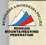
P. V. Tereshkova
Schematic map of the ascent area

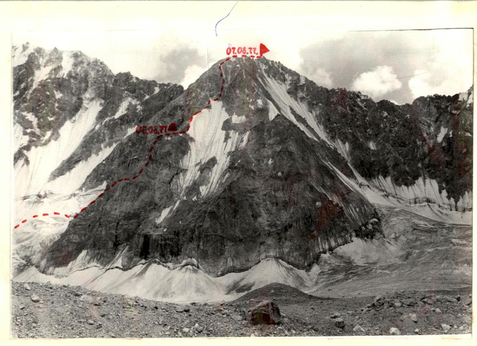
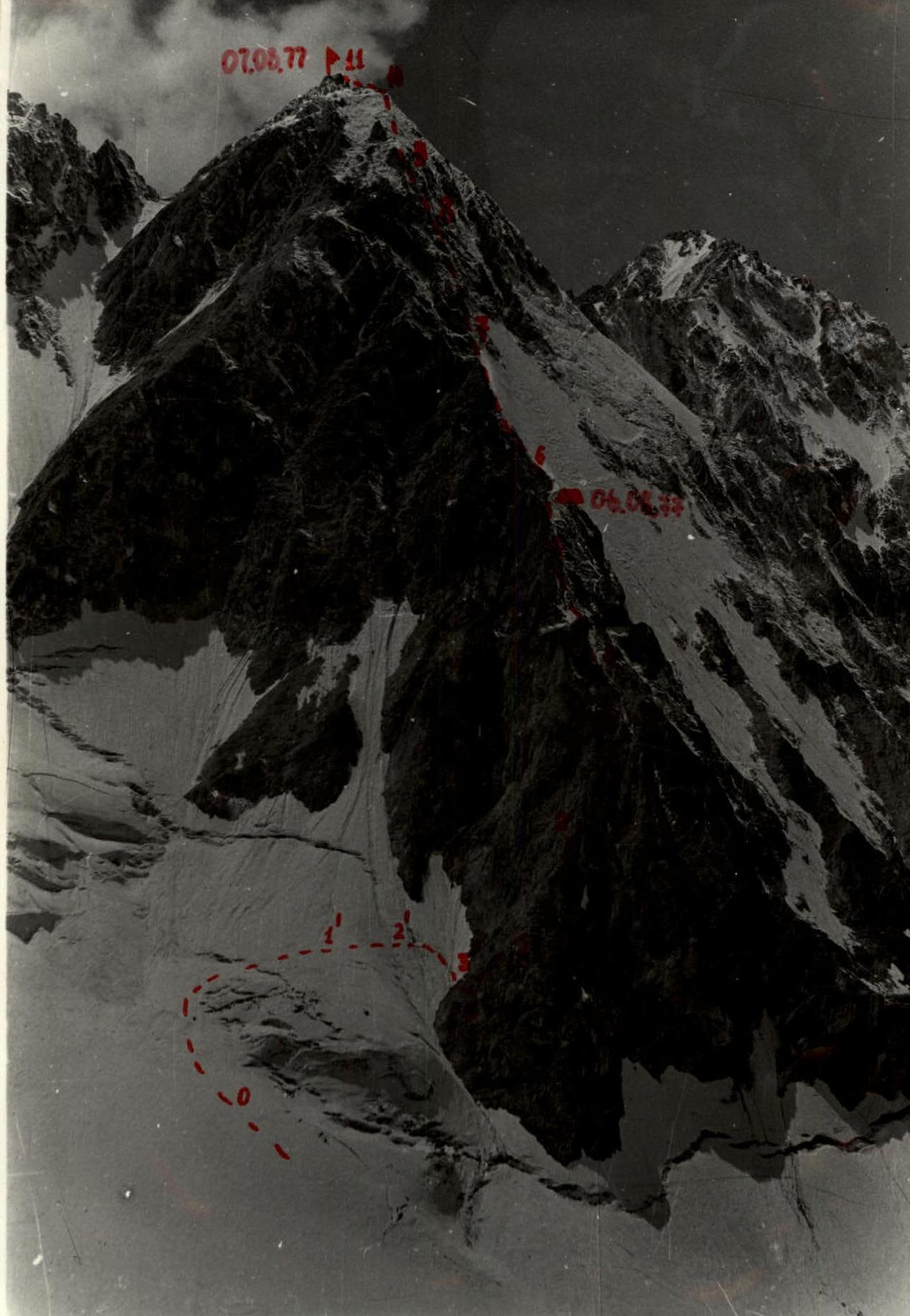
Brief description of the approach to the route on Treshkova Peak via the North-Eastern spur, 5A category.
Initial bivouac — on the moraine of the Kosmonavtov Glacier (3–3.5 hours from the "blockage").
From the moraine, move to the Kosmonavtov Glacier and proceed in the direction of the hanging glacier descending from the northern slopes of the Syinovey Peak, leaving the North-Eastern spur of Treshkova Peak to the right. Approach the ice ledge located in the right part of the snow cirque formed by Bezymannaya Peak, Syinovey Peak, and Treshkova Peak. The start of the route is 50–60 minutes from the bivouac.
Climb up the snow (section 0–1, 100 m, steepness 15–20°) to the ice ledge and, traversing in the direction of the North-Eastern spur of Treshkova Peak across the snow-ice slope (section 1–2, 40 m, steepness 30°), and then down the ice couloir (section 2–3, 40 m, steepness 30°), descend 15–20 m to a talus shelf located under the North-Eastern spur. From the bivouac, 2–2.5 hours.
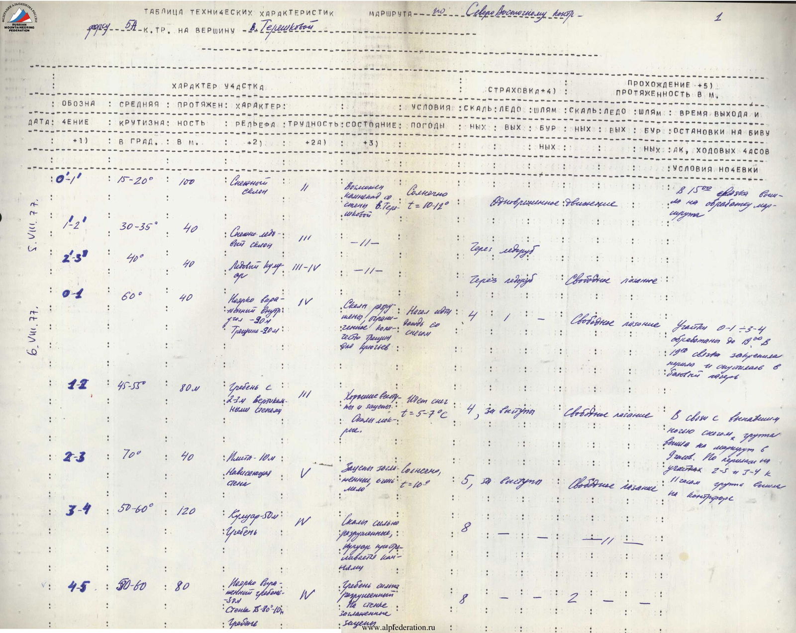
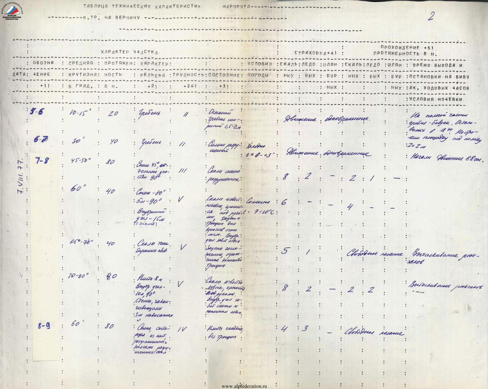
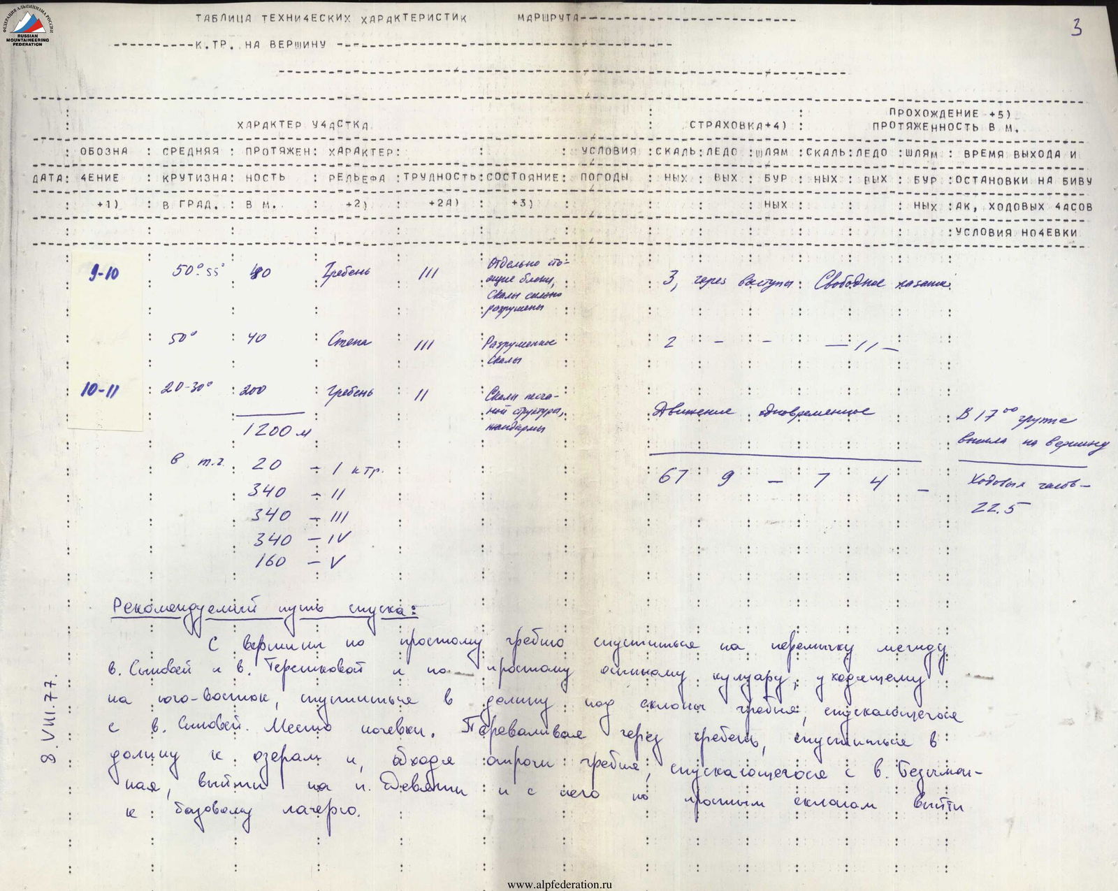
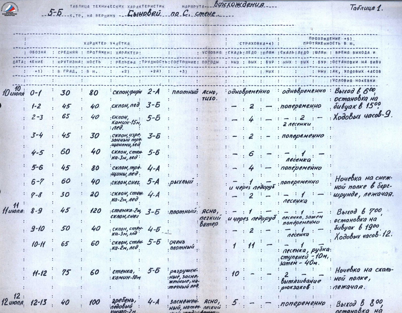
Table of technical characteristics
On the route to V. Tereshkova via the North-Eastern spur
| Section | Date | Steepness | Length, m | Terrain characteristics | Difficulty | Condition | Weather | Belay (rock/ice/bolt) | Passage (rock/ice/bolt) | Time of departure, stop at bivouac, climbing hours | Bivouac conditions |
|---|---|---|---|---|---|---|---|---|---|---|---|
| 0–1 | August 5, 1977 | 15–20° | 100 | Snow slope | 2 | Possible rockfall from the wall of V. Tereshkova | Sunny, t=10–12° | - / - / - | Simultaneous movement / - / - | At 15:00, the rope team started processing the route | |
| 1–2 | 30–35° | 40 | Snow-ice slope | 3 | -//- | - / - / - | Through ice axe / - / - | ||||
| 2–3 | 40° | 40 | Ice couloir | 3–4 | -//- | - / - / - | Through ice axe / - / - | Free climbing | |||
| 0–1 | August 6, 1977 | 60° | 40 | Not clearly defined internal angle 20 m, crack 20 m | 4 | Rocks are destroyed, limited number of cracks for pitons | Rain with snow started | 4 / 1 / - | Free climbing / - / - | Sections 0–1–3–4 were processed until 19:00. At 19:00, the rope team secured the rope and descended to the base camp. | |
| 1–2 | 45–55° | 80 | Ridge with 2–3 vertical walls and ledges | 3 | Good ledges. Rocks are wet. | Snowfall, t=5–7°С | 4 / 3 / - | Free climbing / - / - | Due to the snow that fell during the night, the group departed at 7:00. Sections 2–3 and 3–4 of the category difficulty were completed via the rope on the spur. | ||
| 2–3 | 70° | 40 | Slab 10 m. Overhanging wall | 5 | Ledges are smoothed, very few | Sunny, t=10° | 5 / - / - | Free climbing / - / - | |||
| 3–4 | 50–60° | 120 | Couloir 50 m. Ridge | 4 | Rocks are heavily destroyed, couloir is exposed to rockfall | 8 / - / - | - / - / - | ||||
| 4–5 | 50–60° | 80 | Not clearly defined ridge 30. Ridge on the wall. Wall 15–80–10. Ridge | 4 | Ridge is heavily destroyed. Smoothed ledges | 8 / - / 2 | - / - / - | ||||
| 5–6 | August 7, 1977 | 10–15° | 20 | Ridge | 2 | Talus. Ridge width 1.5–2 m | - / - / - | Simultaneous movement / - / - | On the flat part of the ridge — bivouac. Stopped at 18:30. Built a 2×2 m platform for the tent. | ||
| 6–7 | 30° | 40 | Ridge | 2 | Heavily destroyed | Cold, t=0–3° | - / - / - | Simultaneous movement / - / - | Started moving at 8:00. | ||
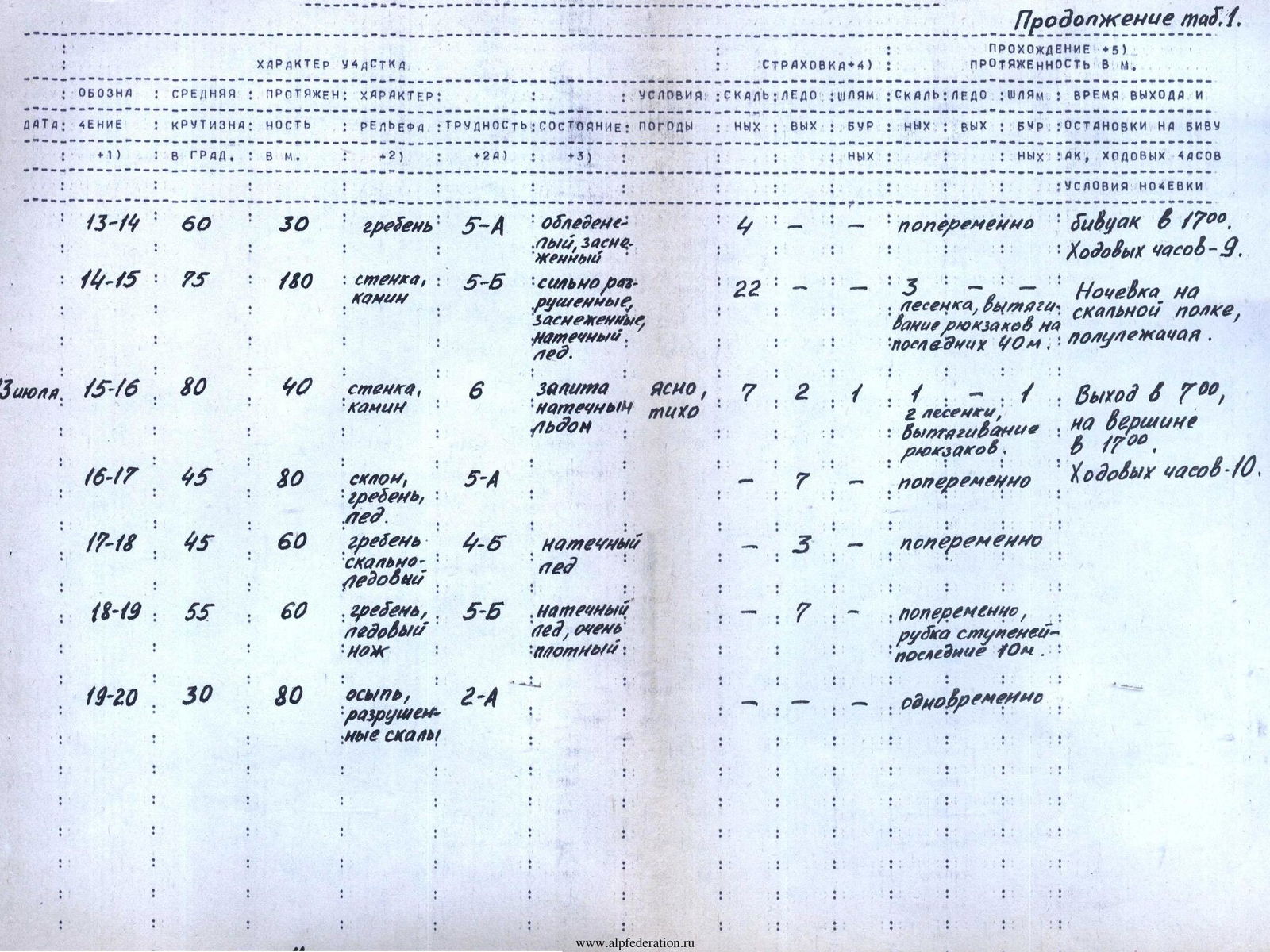
| 7–8 | 45–50° | 80 | Wall 45, individual sections up to | 3 | Rocks are heavily destroyed | 8 / 2 / - | 2 / - / - | ||||
| 7–8 | 60° | 40 | Wall 60°, 5 m — 90°. Internal angle 15 m (gutter) | 5 | Rocks are limestone, crumbling under hands, few ledges and cracks for pitons. Internal angle is filled with ice. | Sunny, t=7–10°С | 6 / - / - | 4 / - / - | Pulling up backpacks | ||
| 7–8 | 65–70° | 40 | Rocks of the "Ram's forehead" type | 5 | Ledges are smoothed, limited number of cracks | 5 / 1 / - | Free climbing / - / - | ||||
| 7–8 | 70–80° | 80 | Slab 8 m. Internal angle 10 m, 90°. Wall ending with 3 m overhang | 5 | Rocks are limestone, crumbling. Internal angle is filled with snow and ice. | 8 / 2 / - | 2 / 2 / - | Pulling up backpacks | |||
| 8–9 | 60° | 80 | Wall consisting of slabs separated by belts of destroyed rocks | 4 | Slabs are smooth, without cracks | 4 / 3 / - | Free climbing / - / 1 | ||||
| 9–10 | August 8, 1977 | 50–55° | 80 | Ridge | 3 | Individual blocks, rocks are heavily destroyed | 3 / - / - | Through ledges / Free climbing / - | |||
| 10–11 | 50° | 40 | Wall | 3 | Destruction | 2 / - / - | - / - / - | ||||
| 10–11 | 20–30° | 200 | Ridge | 2 | Rocks have a sandy structure, gendarmes | - / - / - | Simultaneous movement / - / - | At 17:00, the group reached the summit. Climbing hours — 22.5. |
Brief explanation: Section 0–1. 4th category difficulty, 40 m, steepness 60–65°. From the talus shelf upwards 15–20 m along a not clearly defined internal angle ("live" rocks), and then, moving to the right along a crack, exit to the ridge of the North-Eastern spur (climbing is above average difficulty, limited number of ledges and cracks for pitons).
Section 1–2. 3rd category difficulty, 80 m, steepness 45–55°. Further along the ridge with good ledges and cracks, exit to an inclined shelf under an overhanging rock tower; belay point (climbing is average, местами выше средней трудности, belay is piton).
Section 2–3. 5th category difficulty, 40 m. From the shelf along a crack of a smooth inclined 10-meter slab with a steepness of 50°, with strongly smoothed ledges, approach the overhanging part of the rock tower and along the overhanging rocks traverse to the right to the ridge. Belay point (climbing is very difficult, limited number of ledges, belay is piton).
Section 3–4. 4th category difficulty, 120 m, steepness 50–60°. From here, along the right part of the wall, along the couloir, along heavily destroyed rocks above average difficulty, move under the red overhanging walls and, not reaching the walls 40–50 m, traverse to the right and upwards:
- cross the couloir (the couloir is exposed to rockfall, and in the second half of the day is "shot through" with rocks);
- climbing up along its right side, exit to a rock red tower. Control tour (climbing is above average difficulty, due to the large number of "live" stones, very tense, belay is piton).
From the start of the route — 7–9 hours.
Section 4–5. 4th category difficulty, 80 m, steepness 50–60°. From the control tour upwards along the rocks above average difficulty, moving along the red ridge, approach under a 10–12-meter wall with a steepness of 75° and, overcoming it head-on along very difficult, smoothed rocks with a limited number of ledges, exit to the ridge. Along the steep monolithic rocks of the ridge with uncomfortable, smoothed ledges, climb up to its flat part. Possible overnight stay (climbing is above average difficulty, belay is piton).
From the start of the route — 7–10–12 hours.
Section 5–6. 2nd category difficulty, 60 m, steepness 30°. From the bivouac along a not wide, heavily destroyed ridge, exit under a rock ascent (simultaneous movement).
Section 6–7. 3rd category difficulty, 80 m, steepness 45–50°. From here, first overcoming steep, heavily destroyed rocks of average difficulty, and then monolithic rocks of average difficulty, passing a vertical 3-meter wall with good ledges, exit to a small talus shelf under a 160-meter grey rock wall.
Section 7–8. Key section of the route, 5th category difficulty, 160 m. From the shelf upwards along the right part of the vertical wall ("live" stones, rocks are limestone with inclusions of quartz rocks and granite — crumble) along smoothed rock ascents with a limited number of ledges, местами обледенелым, difficult rocks — ascent to a 15-meter rock gutter filled with snow and ice. Along the difficult rocks of the gutter, approach under a vertical 3–4-meter wall and, overcoming it head-on along difficult, smoothed rocks, exit to a 15-meter talus part of the ridge under the next rock ascent (80 m, climbing is difficult, местами очень трудное, belay is piton, steepness 65–75°).
Further upwards along a smooth, with a small number of ledges, difficult rock wall, exit to a small depression, the exit from which ends with a 1.5-meter overhang (artificial points of support). Overcome the overhang head-on, and then along rocks above average difficulty, местами очень трудным, move to the right and upwards in the direction of the grey rock forehead. Along very difficult rocks of a 15–20-meter smooth vertical wall with inclined cracks, exit to the grey rock forehead ("live" stones). From the top of the forehead along a 6–8-meter smooth, without ledges, steepness 50° slab, approach a 10-meter vertical, with an overhanging left wall, vertical angle filled with snow with icing (artificial points of support). Then move to the right and upwards along difficult, vertical recesses with smoothed ledges along a crack under a 3-meter overhang, which is overcome head-on (80 m, climbing is difficult, местами очень трудное, artificial points of support, ladders, belay is piton, steepness 70–80°, on individual sections 90–95°). On the key section, pull up backpacks.
Section 8–9. 4th category difficulty, 80 m, steepness 60°. Further move upwards in the direction of the gendarmes along smooth, grainy slabs with "live" patches, overcoming rocks above average difficulty. Having passed a 2-meter rock wall, bypass the gendarmes to the right along the field wall of the couloir and, moving along steep, with "live" stones, местами обледенелым rocks above average difficulty, approach under a rock ascent leading to the pre-summit ridge (belay is piton).
Section 9–10. 3rd category difficulty, 80 m, steepness 50–55°. Along steep monolithic slabs of average difficulty of the rock ascent with good ledges and cracks for pitons, exit to the pre-summit ridge. Possible bivouac.
Section 10–11. 2nd category difficulty, 200 m, steepness 20–30°. Moving along the ridge simultaneously, bypassing gendarmes to the right and left, exit to the summit. From the bivouac — 9–12 hours.