Sauk-Dzhaylau (Carpathian Military District) CA by 3B cat. diff., O. Onysko, 80
1. Team preparation for the ascent. Information about reconnaissance.
The current team of climbers from the Carpathian Military District is a collective that has existed for many years. This team constantly conducts joint training and has repeatedly made joint climbs of various difficulty categories, up to the highest. Team members took part successfully in the Championship of the Soviet Army and Navy in 1979.
The Carpathian Military District team was preparing to participate in the technical class within the framework of the 1980 Soviet Army and Navy Championship in two directions:
- Physical, technical, and tactical training.
- Evaluation of information about the championship area, selection of the ascent object, and direct reconnaissance of the area.
Physical, technical, and tactical training was conducted in two stages:
- The first stage — at the place of residence.
- The second stage — in the Fann Mountains.
General physical training was conducted:
- In the summer — three times a week.
- In the winter — twice a week, and the team also conducted sessions at the ski base in the Carpathians at least twice a week.
Comprehensive improvement of rock climbing techniques was achieved on rock massifs within the district — in the Carpathians and near Lviv. Particular attention was given to practicing free climbing techniques in bad weather conditions (snow, rain, cold).
At the same time, special equipment was being prepared, and its comprehensive testing was carried out, along with studying the techniques of its use.
In the Fann Mountains area, the team's readiness for the Championship was tested. On technically complex ascents of 5th and 6th cat. diff. (Arg by the northern wall, Sugar Head by the northern wall, Bodkhona by the western buttress and the western wall), the team finally tested its tactical maturity.
According to preliminary data, it was known that one of the probable areas for the championship was Archa-Kanysh. Therefore, the team prepared in advance an object for ascent in the technical class — the western wall of the Sauk-Dzhaylau peak, which the team's coach, V. Bolychevsky, observed back in 1978 during an ascent to Central and Main Sauk.
The wall of the South-Eastern Sauk attracted the team with its straightforwardness, specifically that it allowed for a route that was:
- Complex;
- Logical;
- And quite safe.
The technical difficulty of the wall is evidenced by the fact that it was featured in the application for the 1976 USSR Climbing Championship.
The final choice of the route on the wall was made after a reconnaissance trip to the upper cirque of the Sauk Glacier on August 13, 1980 (Onysko and Labzhinsky). Photos of the facade and profile of the wall were taken then.
II. Tactics of the ascent
After detailed reconnaissance and consultations with the team's coach, V. Bolychevsky, a final tactical plan for the first ascent of the western wall of the South-Eastern Sauk-Dzhaylau peak was drawn up.
The tactics of our ascent were largely determined by the overall character of the wall section of the route. On this wall, two huge rock formations in the form of elongated rhombuses can be distinguished. The line of the route chosen by the team runs precisely along the left edge of the "rhombuses" located one under the other, with an exit to the summit tower. According to the tactical plan, the passage of the wall was planned with four bivouacs:
- on the first rhombus;
- in the middle of the second rhombus;
- at the top of the second rhombus;
- on the summit tower.
Such a tactical plan was chosen based on the technical difficulty of the route and the actual weather conditions in the area, as forecasted for the time of the ascent.
The team's work on the route was planned with independent rope teams on sections up to 5 cat. diff. At the same time, all participants take turns working as the first on the rope.
The movement tactics are flexible; the entire team can immediately switch to a rope system if the route becomes more complicated.
The movement of participants is carried out only on a double rope, which provides an increased safety guarantee on a route with rockfall hazards.
To ensure safety on the route, the team also had a wide range of equipment, including:
- Rock hooks and titanium wedges;
- Ice screws and "corkscrews";
- Various configurations and sizes of stoppers.
A novelty is the use of rigid titanium wedges (profiled) like "bong-bong", which "hold" well in shallow cracks.
On ice and icy rocks:
- The first person moves in twelve-toothed crampons like "Tirol";
- The rest follow the rope in Vibram boots.
A pair of galoshes is taken for traversing the steep rocks of the second "rhombus".
The amount of equipment and the set of food products are selected to ensure the group's safety and minimize weight, so as to avoid pulling backpacks.
Thus, three team members go with backpacks (weight 10 kg);
- The first one goes with a maximally lightened backpack (weight not more than 2 kg).
And only on key sections (the upper part of the second "rhombus") is the first person completely freed from the backpack.
The team adhered to the planned plan completely, which confirmed the correctness of the team's actions and their assessment of the route's difficulty and weather conditions.
III. Table of equipment and food products
| № | Name of equipment, clothing, footwear | Quantity | Used on route section | Total weight, kg |
|---|---|---|---|---|
| I. Group equipment | ||||
| 1. | Main rope 10 mm produced: | |||
| domestic, 40 m | 2 | 0–26 | 5.6 | |
| FRG, 40 m | 2 | 0–27 | 6.8 | |
| 2. | Auxiliary rope, 40 m | 1 | on descent | 1.2 |
| 3. | Loops-extensions from main rope | 8 | 2–26 | 0.64 |
| 4. | Carabiners "Irbis" | 42 | 0–27 | 3.15 |
| 5. | Rock hammer | 2 | 0–26 | 2.0 |
| 6. | Three-step ladders | 4 | 2–12 | 0.8 |
| 7. | Twelve-toothed crampons "Tirol" (pairs) | 1 | 0–2, 17–26 | 0.8 |
| 8. | Titanium rock hooks | 34 | 2–26 | 1.7 |
| 9. | Titanium wedges | 18 | 2–26 | 1.8 |
| 10. | Various stoppers | 7 | 2–22 | 0.45 |
| 11. | Titanium ice hooks | 8 | 0–2, 7–8, 11–12, 16–20, | 0.56 |
| 23–26 | ||||
| 12. | "Yuvel" primus stove | 1 | — | 0.4 |
| 13. | B-70 gasoline in canister, liters | 1 | — | 0.9 |
| 14. | 2-liter pot | 1 | — | 0.2 |
| 15. | First-aid kit (set) | 1 | — | 0.35 |
| 16. | "Pamirkа" tent | 1 | — | — |

Photo 2. Route profile.
Profile scheme
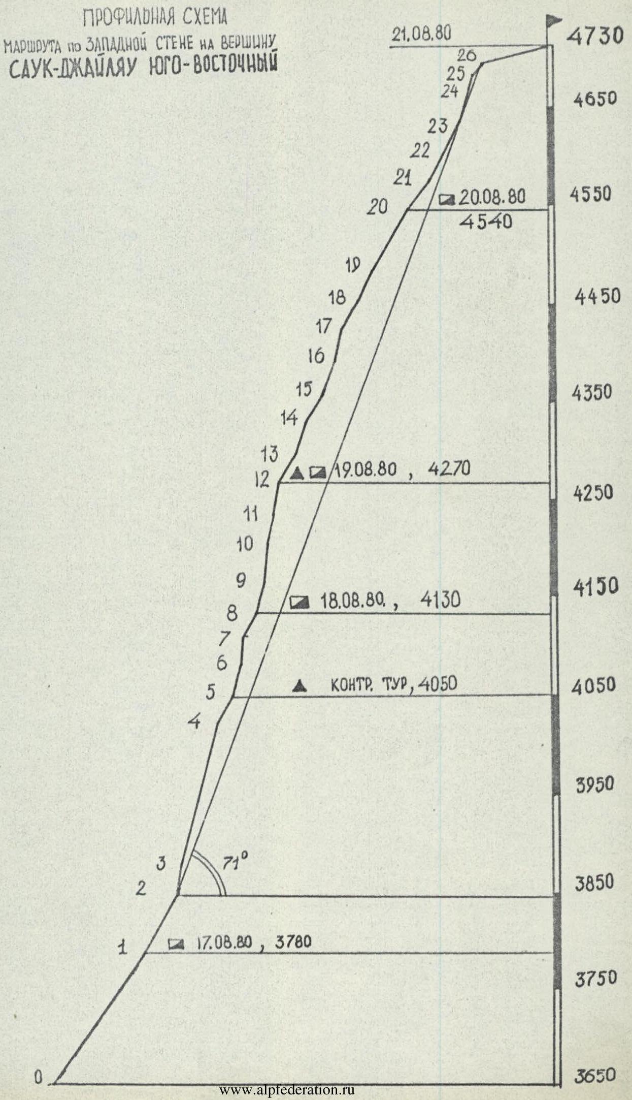 Profile scheme of the route on the Western wall to the Sauk-Dzhaylau South-Eastern peak.
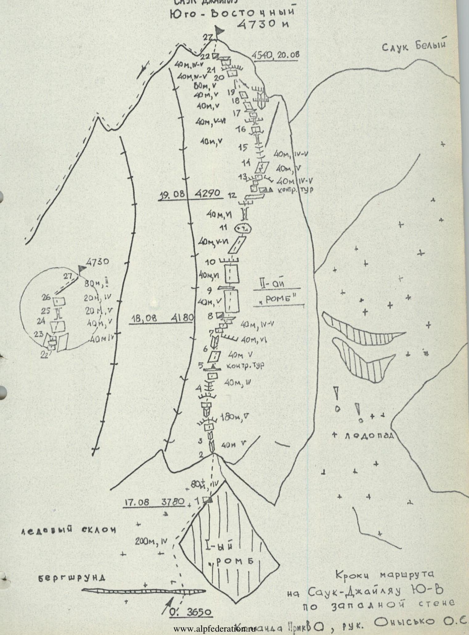
Table of main characteristics of the ascent route to the South-Eastern Sauk-Dzhaylau peak via the Western wall.
| Date | Sect. № | Avg. slope | Length, m | Relief characteristics | Difficulty | Condition | Weather conditions | 9 | 10 | 11 | 12 |
|---|---|---|---|---|---|---|---|---|---|---|---|
| 17.08 | 1 | 55° | 200 | Ice slope with bergschrund | 4 | dense ice | satisfactory | — | 10 | — | — |
| Overnight stay on the left edge of the first "rhombus", sitting. For safety, | 4 | 2 | — | — | |||||||
| 200 | Total for the day | 4 | 12 | — | — | ||||||
| 18.08 | 2 | 60° | 80 | Ice slope | 4 | dense ice | good | — | 5 | — | — |
| 3 | 80° | 40 | Inner corner | 5 | monolith | — | — | 9 | — | — | |
| 4 | 75° | 180 | System of inner corners with overhangs and walls | 5–6 | monolith, with ice | — | 28 | 6 | — | — | |
| 5 | 60° | 40 | Wall | 4–5 | destroyed, with ice. | — | — | 5 | — | — | |
| 6 | 75° | 40 | Slabs | 5 | monolith | cloudy | — | 7 | — | — | |
| 7 | 85° | 40 | Inner corner with overhang. | 6 | monolith | — | — | 8 | 4 | — | |
| 8 | 60° | 30 | Wall with ice. | 4–5 | destroyed | — | — | 4 | 1 | — | |
| 9 | 75° | 40 | Snowy slabs | 5 | monolith | snow, thunderstorm | — | 8 | 2 | — | |
| Sitting overnight stay on a small ledge at the end of section 8. Driven on overnight stay | 3 | — | — | — | |||||||
| 480 | Total for the day | 72 | 6 | 12 | 7 | ||||||
| 19.08 | 10 | 85° | 40 | Slab wall, cornice | 6 | monolith with ice | good | — | 13 | — | 3 |
| 11 | 80° | 40 | Slab | 5–6 | monolith with ice | — | — | 10 | — | 5 | |
| 12 | 80° | 40 | Chimney, closed by a cornice | 6 | filled with ice | snow | — | 10 | 2 | 2 | |
| 13 | 60° | 40 | Overhanging wall, stepped rocks | 5 | with ice, snowy | snow | — | 8 | — | — | |
| 14 | 70° | 40 | Slab with a cleft | 5 | snowy | snowfall | — | 6 | — | — | |
| 15 | 60° | 40 | Inner corner | 4–5 | snowy | — | — | 6 | — | — | |
| Sitting overnight stay at the end of section 12 on a small ledge. Drven on overnight stay | 3 | — | — | — | |||||||
| 280 | Total for the day | 56 | 2 | 10 | 14 | ||||||
| 20.08 | 16 | 70° | 40 | Overhanging chimney | 5–6 | with ice | good | — | 8 | — | 2 |
| 17 | 72° | 40 | Wall, overhanging chimney | 5–6 | with ice | — | — | 10 | 2 | 1 | |
| 18 | 60° | 40 | Wall | 5 | destroyed, with ice | satisfactory | — | 5 | 3 | — | |
| 19 | 65° | 40 | Slab-like wall | 5 | destroyed, with ice | — | — | 8 | 2 | 1 | |
| 20 | 60° | 80 | Rocky couloir, filled with snow and ice | 6 | thin layer of wet snow | good | — | 3 | 13 | — | |
| 21 | 55° | 40 | Overhang. wall, stepped rocks | 4–5 | destroyed | good | — | 5 | — | — | |
| 22 | 60° | 40 | Stepped rocks | 4 | destroyed | — | — | 5 | 2 | — | |
| 23 | 65° | 40 | Inner corner, slabs | 5 | snowy | — | — | 7 | 2 | — | |
| Sitting overnight stay at the beginning of section 21. Driven on overnight stay | 2 | — | 1 | — | |||||||
| 320 | Total for the day | 53 | 20 | 7 | — | ||||||
| 21.08 | 24 | 70° | 40 | Wall | 5 | destroyed, with ice | good | — | 7 | 2 | — |
| 25 | 75° | 20 | Chimney | 5 | — | — | — | 5 | 3 | — | |
| 26 | 50° | 20 | Wall | 4 | — | — | — | 3 | — | — | |
| 27 | 20° | 80 | Ridge | 2 | — | — | simultaneously | ||||
| 160 | Total for the day | 15 | 5 | — | — | ||||||
| 1440 | TOTAL FOR THE ROUTE | 200 | 45 | 29 | 26 |

Team captain O. Onysko
Explanations for the table of main characteristics
August 17, 1980. Ascent at 6:00. The duty officers in the base camp had already prepared a hearty and nutritious breakfast. At 7:00, we set out lightly from the base camp on the Sauk Glacier.
The approach to the route goes:
- First along the right side of the Surmetash River (in the direction of travel) to the place where the Dzhindy-Su River flows into it (2.5–3 hours from the base camp).
- Above the confluence, we cross the Surmetash River via a bridge and move along the right side of the Dzhindy-Su River to the "ram's foreheads" where the crossing is located.
- After crossing, we go straight up the "ram's foreheads" to a grassy slope, along which we ascend to the moraine of the Sauk Glacier.
- Along the moraine, we go straight up to the overnight stays (3–4 hours).
All participants arrived at the overnight stays at 12:30. After rest and lunch, we set out on the route at 15:00. After 45 minutes of ascent along the glacier, we approached the base of the "rhombus". Here, we tied in and began advancing up the steep ice slope. We overcame the bergschrund. Onysko, wearing crampons, ascended first; the rest followed the rope with the help of jammers. We belayed through ice screws.
The weather, initially satisfactory, began to deteriorate. Fine snow grains fell, and the wind strengthened. After climbing about 200 m, we spent the night on the left edge of the first "rhombus".
August 18. In the morning, it was very cold. We got up at 7:00. After breakfast, we set out on the route at 8:00. We moved along steep ice towards an inner corner resembling an open book. After climbing 80 m, the first person reached the rocks. Climbing is possible only in galoshes. The first impression of the rocks is good; the rocks are:
- exposed;
- monolithic.
Straight up, there is a system of inner corners and walls. There are not many holds on the rocks, but there are cracks for driving hooks. "Bong-bong" hooks and stoppers work well.
After 220–240 m of ascent, the character of the rocks changes. Ahead lies a destroyed and icy wall leading to a vaguely expressed ridge. Here, we set the first control cairn.
From the cairn:
- straight up along steep slabs;
- under a large cornice, which is bypassed on the left along an overhanging inner corner.
Climbing is very challenging. Stoppers help well.
After the corner, the difficulty of the route somewhat decreases. Monolithic sections are no longer encountered. After climbing 40 m along destroyed and snowy rocks, we reach the key part of the route.
The first rope is very difficult; icy slabs complicate the movement straight up. The weather continues to deteriorate, and at 16:00, after we passed one rope of the key section, a thunderstorm began. Under these conditions, we decided to descend down a rope and spend the night on a small ledge.
August 19. There is a lot of fresh snow on the rocks. We set out quite late due to the cold. After passing the first processed rope, the first (Onysko) began to move up along an icy wall with cornices. Climbing is very difficult, further complicated by:
- snow;
- ice lying on the rocks.
Movement is very slow; hooks are hard to place because it's difficult to find cracks. Again, stoppers come to the rescue.
After the cornice, the route goes straight up along a steep icy slab, at the end of which there is a change of lead. Our chimney specialist, Sergey Labzhinsky, moves forward. He faces a narrow, overhanging chimney, with its lower part filled with ice.
After several attempts to use ice hooks:
- it is possible to pass the first most difficult meters of the chimney;
- then it widens, and movement becomes more natural.
The exit from the chimney is closed by a cornice, the passage of which takes a lot of effort. At 17:00, the team decides to stop for the night at the top of the second "rhombus" (at the exit from the chimney). One pair continues to work on the route, processing the further path.
August 20. After passing three processed ropes, we approach under a snowy, icy wall with an overhanging chimney. Labzhinsky leads ahead. After passing a series of complex walls and chimneys, over 80 m, he agrees to be replaced by Gusakovsky. The rocks are very difficult, and movement is slow. Ahead lies an overhanging inner corner, closed by two cornices. We bypass it on the right, following steep, destroyed slab-like rocks, and enter an icy rocky couloir leading to the pre-summit tower. Here, Onysko moves forward, wearing crampons.
First along the right, then along the left part of the couloir, we move up towards the tower. At 18:00, we find a small area and stop for the night.
- Onysko–Labzhinsky prepare a site for a sitting bivouac;
- Kleymenov–Gusakovsky process the lower part of the tower.
The tower is traversed along a helical line from right to left; first along monolithic stepped rocks, then along steep icy slabs. At 20:30, everyone gathered at the overnight stay.
August 21. We quickly pass two processed ropes and move further straight up along destroyed, icy, and snowy rocks. Another two ropes — and we reach the pre-summit. Along a simple, destroyed ridge, we ascend to the summit of the South-Eastern Sauk (at 10:00).
We descend via the route of 5A cat. diff., along the northern wall in the direction of the 4130 m pass. 17 rope descents take us 8 hours, and at 20:40, we meet our observers on the glacier.