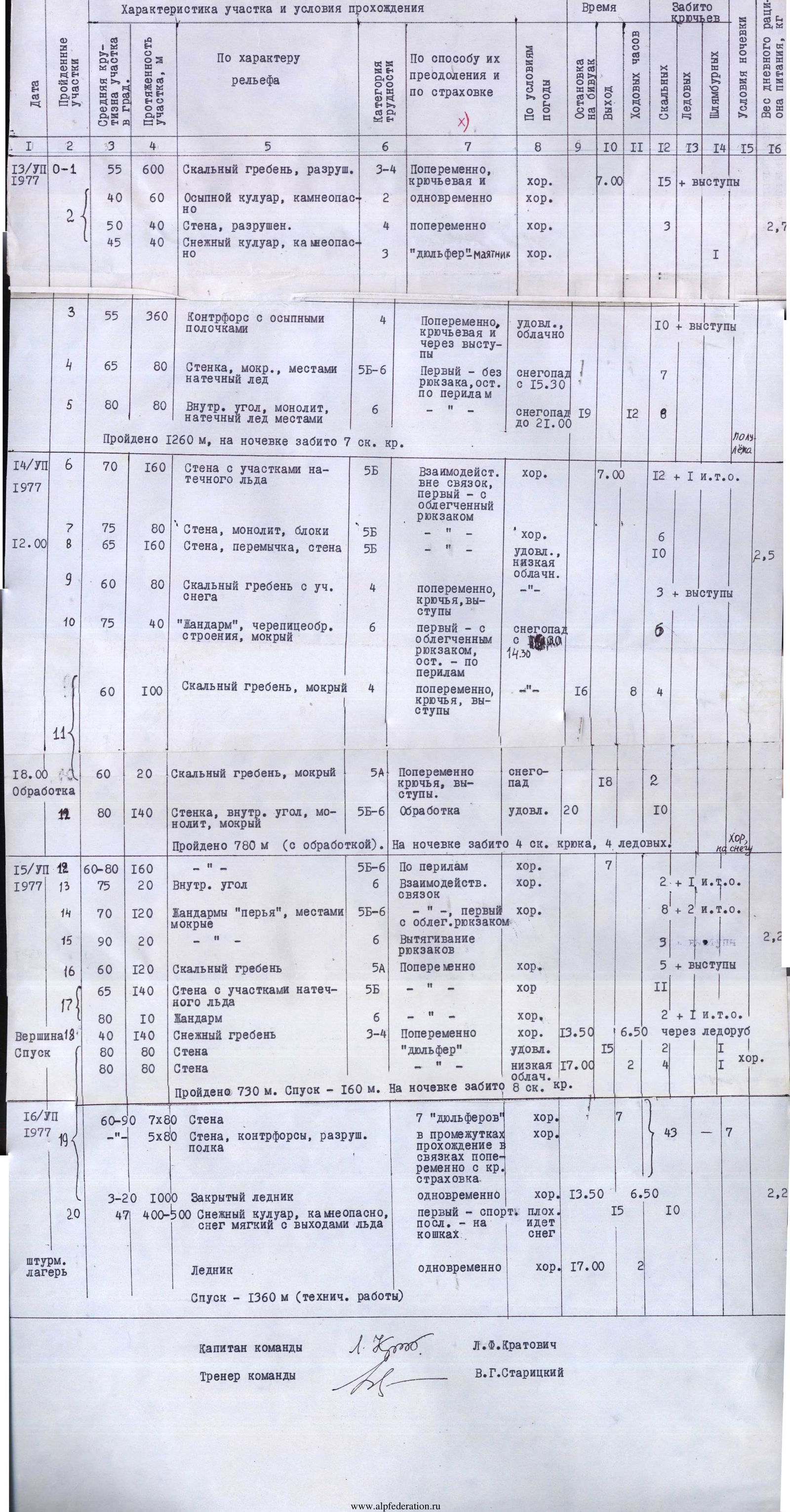
Ascent Passport
- Ascent class - technical
- Ascent area (according to KTMGV) - northern spur of the Alay ridge (5.1)
- Peak, its height and ascent route - peak Sauk-Jaylyau Eastern, 4960 m, via the northern ridge
- Proposed difficulty category - 5B
- Route characteristics:
height difference: 1460 m from the assault camp, 1270 m from the saddle
average steepness: 65°, section lengths: 1 - 0 m; 2 - 60 m; 3 - 40 m; 3-4 - 740 m; 4 - 580 m; 5 - 140 m; 5 - 540 m; 5-6 - 340 m; 6 - 170 m
- Number of pitons driven: for belaying - 128 (rock), 0 (ice), 10 (bolts, on descent); for creating I.T.O. - 5
- Number of travel hours - 40 hours
- Number of nights and their characteristics - 3: (1st night - semi-sitting; 2nd and 3rd - good)
- Surname, name, patronymic of the leader and participants, sports qualification:
Kratovich Leonid Fedorovich - leader, 1st sports category Markelov Viktor Viktorovich - participant, Master of Sports Gavrilov Gennadiy Alekseevich - participant, Master of Sports Lobachev Evgeniy Aleksandrovich - participant, 1st sports category Nezamutdinov Aidar Boratovich - participant, Master of Sports Krapivin Valentin Nikolaevich - participant, Candidate Master of Sports
- Team coach:
Staritskiy Vladimir Grigorievich - Master of Sports, senior instructor, honored coach of the RSFSR
- Date of departure and return - 12.07-16.07.1977
Agreed - CMS VSPS S. Ovcharov
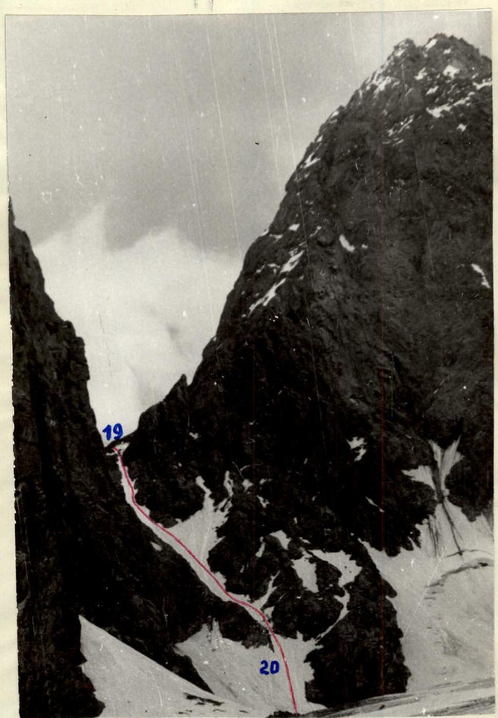
Descent path from the saddle (4130 m) between Eastern and South-Eastern Sauk-Jaylyau (section 19-20)
1. Brief geographical description and sports characteristics of the ascent object
The Sauk-Jaylyau massif is located in the northern spur of the Alay ridge. The cirque is horseshoe-shaped, open to the north. Inside the cirque, there is significant glaciation - a glacier approximately 1-3 km in size and snow-ice slopes of northern and eastern exposure reaching the peaks.
The Dzhindy-Su river flows out of the glacier, descending into the Surmetash gorge and flowing into the Surmetash river. The Dzhindy-Su river is quite full-flowing and is difficult to cross in the second half of the day. The glacier tongue ends in an icefall.
In the southern part of the horseshoe are the peaks: Central (5225 m), named by the first ascenders, and Main.
In the western part of the horseshoe, two peaks stand out: Western Sauk-Jaylyau I and II.
In the eastern part, the following can be identified: White (4800 m), South-Eastern (4730 m), and Eastern (4960 m) Sauk-Jaylyau. The latter peak is separated from the main massif by a deep saddle (4130 m); between the other peaks, the ridge does not drop below 4500 m. From all peaks, ridges extend outward from the horseshoe. Inward, a short ridge starts slightly east of Central Sauk-Jaylyau. To the east, the peaks are mainly rocky; to the west, they are snow-rock-ice.
The most interesting routes:
- from the cirque to the peaks of the massif are not below 5th category of difficulty, and to the Central and Main peaks - 6th category of difficulty;
- most routes are of the wall type;
- all routes from the cirque are climbed from the north and along the walls with a northern orientation.
The first sports ascents on the peaks of the Sauk-Jaylyau massif were made in 1977 by participants of training camps from Uzbekistan (Central and Western Sauk-Jaylyau - June) and Leningrad (Eastern and South-Eastern Sauk-Jaylyau - July).
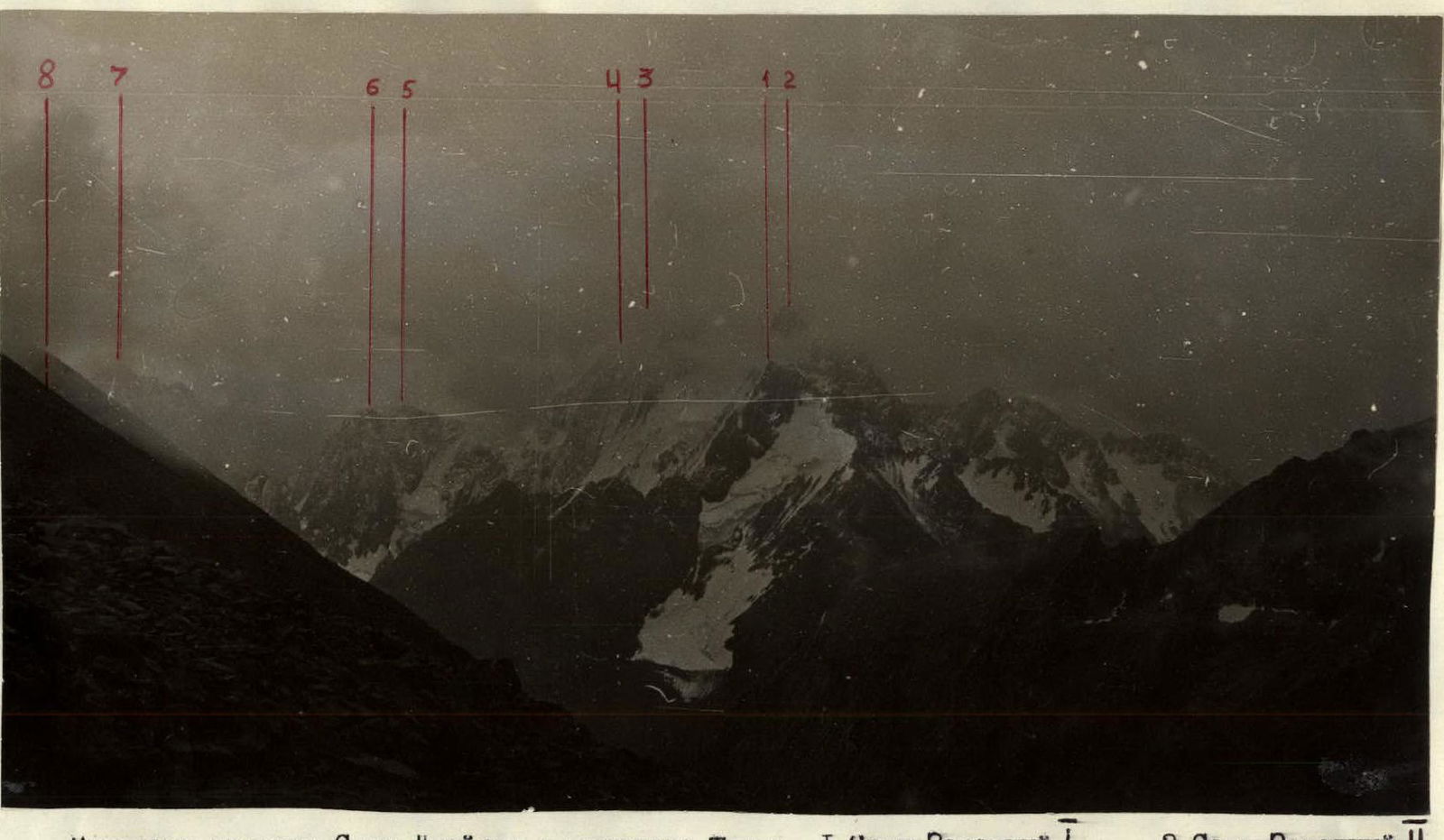
| Panorama of the Sauk-Jaylyau massif from Trum pass: | 1 – Sauk Western I | 2 – Sauk Western II |
|---|---|---|
| 3 – Sauk Central | 4 – Sauk Main | |
| 5 – Sauk White | 6 – Sauk South-Eastern | |
| 7 – Sauk Eastern | 8 – Sauk Dvuzubka |
2. Brief description of ascent conditions in the given area
2.1. Relief features
The rocks of the massif are composed of granites and granodiorites, with a predominant angle of inclination of slabs and macro-relief walls of 70°-75°, starting at various levels from the North Sauk-Jaylyau glacier. The lower part of the slopes is heavily destroyed, the middle part is pedestal-like, monolithic, with few cracks and poorly developed micro-relief (requiring passage of 10-15 m sections on friction); the upper part has greater dissection with good cracks for belaying. Starting from 4200 m, there are extended sections of rocks with ice formations.
It should also be noted that the rocks from 4000 m and practically to the summit on the northern side of the massif are overgrown with lichens, which, under conditions of bad weather, abundant snow and ice melting, create particularly difficult climbing conditions.
2.2. Weather conditions
The Sauk-Jaylyau cirque has a unique microclimate associated with the high altitude of the massif, its enclosed nature, and glaciation. Practically every day from 12:00 to 18:00, local cloudiness or fog forms, developing from clouds coming from the Alay valley, with precipitation in the form of snow or snow grains.
2.3. Remoteness from populated areas, alpine bases, and communication routes; exploration of the area
The area is quite remote from populated areas and is a day's journey from the nearest populated point, Karaul, and a day's journey from the nearest road, Uch-Kurgan-Lyanguar. From the "Dugoba" tourist center to the Sauk-Jaylyau gorge, one can reach in a day through the Ak-Tash pass (4200 m); the approaches from the Shakhimardan settlement through the Trum pass are somewhat longer.
The Sauk-Jaylyau massif first attracted attention as an ascent object by V.A. Elchibekov, G.N. Ovcharov, S.M. Savvon, and other climbers during the first ascent of the Shait peak. However, until this year, no ascent attempts were made. Available maps do not accurately reflect the arrangement of the massif's ridges.
3. Reconnaissance
The beginning of the reconnaissance of the massif dates back to September 1975, when a group consisting of:
- Shulga Yu.D.,
- Vikharev B.I.,
- Popolzina Z.I.,
- Shaposhnikov S.I. ascended to the cirque and photographed Sauk-Jaylyau.
In August 1976, a group from the "Polytechnic" sports club: Ilyin A.I., Pukhovitskiy V.F., Markelov V.V., Lobachev E.A., and Kratovich L.F. ascended to the cirque, conducted photography, and examined possible objects for ascents. In that same year, Markelov V. and Kratovich L. ascended to the saddle (3690 m) in the rocky ridge of Eastern Sauk-Jaylyau, examined the path to the peak. The group planned an ascent on the Central peak but was forced to abandon it due to several reasons.
In the 1977 season, additional reconnaissance was conducted. On July 11, the pair Markelov V. - Kratovich L. conducted a new reconnaissance, laid out new approaches along the rocks of the left bank of the Dzhindy-Su river, hung ropes on marble slabs (50°-55°) and on "ram's foreheads" (45°), ascended to the upper cirque, and outlined the main variant for ascending Eastern Sauk-Jaylyau. The group did not make preliminary caches on the route.
4. Organizational and tactical ascent plans made before departure and adjustments made during the ascent. Ascent tactics
The carefully studied route and its beginning - a rocky ridge - did not require additional processing. However, to reduce the time of approach and ensure its safety, it was decided:
- To abandon crossing the Dzhindy-Su river.
- To abandon ascending to the cirque along the right (orographic) part of the glacier.
- To explore the possibility of exiting into the cirque directly along the rocks of the left bank.
On July 11, 1977, the pair Markelov V. - Kratovich L. departed at 10:00 for reconnaissance - route processing. 240 m of ropes were hung (on bolt pitons), the approach path was marked; the pair outlined possible ascent paths and checked radio communication between the upper cirque and the base camp. The same day, the pair returned to camp. Comparing the current approach path with those during the 1976 cirque reconnaissance, the group adopted the new variant.
The route to Eastern Sauk-Jaylyau was climbed by three teams. The first team was engaged in choosing and processing the route, the third team extracted pitons and prepared equipment for transfer forward, and the second team transferred equipment to the first and pulled up backpacks in particularly difficult sections. The second team's functions also included keeping the ascent diary.
All difficult sections of the route with 5B and 6 categories of difficulty were climbed using free climbing. The presence in the team of the strongest rock climbers in the USSR (V. Markelov, G. Gavrilov, and E. Lobachev) significantly accelerated the passage of the routes.
New samples of mountaineering equipment were used on the route:
- cams of various configurations,
- a descending device (of a slotted type),
- 12-tooth crampons.
Titanium ice screws - ice drills with a 2-start screw were also taken on the route, but due to the relief's character, they were not needed during the ascent. They were used when setting up a tent on snow for the second night.
The safety of the ascent was ensured by:
- the correct selection of universal equipment tested for strength,
- careful route selection,
- reliable radio communication with the base camp.
Practically the entire set of equipment, starting from the first night, was redistributed so that the first climber had only a windbreaker and a down jacket in their backpack; particularly difficult sections were climbed by the first without a backpack.
The route was climbed using a double rope, which significantly increased the safety of passage and improved the interaction between teams, and the chosen rope length substantially accelerated the descent from the peak, allowing for 80-meter rappels on the wall.
Radio communication was carried out using "Nedra" radio stations. Normal communication with the base camp was maintained throughout almost the entire route. During the descent along the southern wall, radio communication with observers was maintained from the Sauk-Jaylyau glacier.
Tactical ascent plan by days:
-
Day 1. Approach from the base camp to the Surmetash gorge onto the Sauk-Jaylyau glacier. Organization of the assault camp. Plan fulfilled.
-
Day 2. Early exit from the assault camp. Exit to the saddle. Processing the start of the route was not planned. Passage of part of the route. Plan fulfilled (with some delay due to bad weather starting at 13:40 and continuing almost until morning).
-
Day 3. According to the plan - exit to the summit. Actually, due to bad weather, the group stopped for the night at 16:00. Processing 160 m of rocks. Thus, a deviation from the plan emerged. During radio communication at 20:00, the group requested an extension of the control time by a day. Permission was granted.
-
Day 4. According to the original plan - descent and return to the base camp. Actually, on this day, at 13:50, the group reached the summit. Began descent along the southern wall. At 17:00, due to fog, the group stopped for the night.
-
Day 5. Descent along the wall to the Eastern Sauk-Jaylyau glacier. Ascent to the saddle between Eastern and South-Eastern Sauk-Jaylyau. Descent along a snowy couloir to the glacier, return to the assault camp. Return to the base camp.
5. Composition of the assault group
The team is composed of representatives from two institutes: Polytechnic and Mining.
Team composition:
- Kratovich L.F. - captain, 1st sports category
- Markelov V.V. - participant, Master of Sports
- Lobachev E.A. - participant, 1st sports category
- Gavrilov G.A. - participant, Master of Sports
- Nezamutdinov A.B. - participant, Master of Sports
- Krapivin V.N. - participant, Candidate Master of Sports
Breakdown by teams:
- Nezamutdinov A. - Krapivin V.
- Lobachev E. - Gavrilov G.
- Markelov V. - Kratovich L.
The composition of the teams remained practically the same throughout the ascent. The relatively long duration and complexity of the route required a change of leaders in the teams and a change of teams (see section 6).
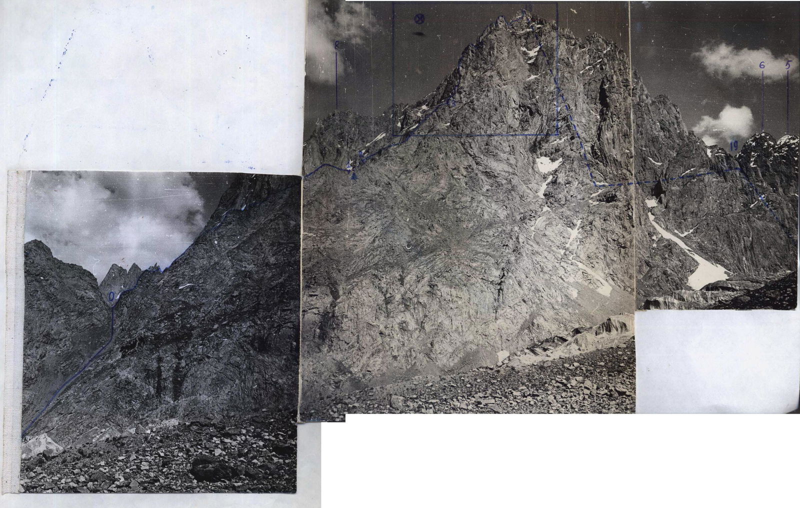
6. Order of route passage
First day - July 12, 1977. At 10:45, the group departed on the route from the base camp. Along marble slabs with a steepness of 50°-55° on the left bank of the Dzhindy-Su river, they ascended 160 m upward with backpacks along previously hung ropes (July 11, 1977), and exited onto the lateral moraine of the Sauk-Jaylyau glacier. Further, 300 m to the right upward along the moraine to a stream in a rocky bed on "ram's foreheads" on the left bank of the Dzhindy-Su river.
Along hung ropes (80 m) upward - exit to a steep lateral moraine covered with grass. Along the lateral moraine upward to the camping sites. The assault camp was organized on grass near the spurs of the peak Western Sauk-Jaylyau. The night's stay was comfortable, with a stream. The height of the night's stay was 3500 m. The approach from the base camp took 4 hours.
Second day - July 13, 1977, departure at 7:00. From the camping sites, crossing the Sauk-Jaylyau glacier, they moved to the moraine. Along a grassy- talus couloir, they ascended to the lowest saddle (3690 m) in the northern ridge of Eastern Sauk-Jaylyau. The exit to the saddle from the camping sites took 0.5 hours.
The first team, Lobachev E. - Gavrilov G., began moving along the rocky ridge (section R0-R1, see "Table", appendix No...), leading to the northern wall. On this section:
- movement in teams,
- alternating belaying,
- pitons were driven,
- natural holds were maximally utilized.
The group covered 600 m of the ridge in 3 hours; the weather began to deteriorate. At a rocky outcropping at the end of the section, a control cairn was built. From here, the first team, Markelov V. - Kratovich L., moved forward. The direction of movement was to the left, crossing an osypnoy couloir (60 m), a rocky wall (40 m), and by a diagonal rappel - crossing a steep snowy couloir (stone-dangerous!). Observation of the upper part of the couloir was mandatory during its crossing by a participant. Upward along the opposite side of the couloir (40 m) - exit to a counterfort with individual ledges. Along the counterfort, 4 × 80 m ropes in the direction of the pre-summit tower. Features of the section:
- rocks covered with lichens,
- many loose stones.
It snowed.
By the time the pre-summit tower was passed (section R3-R5), the freshly fallen snow significantly complicated its passage. The first climber, Lobachev E., in galoshes, without a backpack, ascended 40 m upward on wet slabs, then 40 m to the right to an internal angle formed by large marble blocks covered with lichens, and from about the middle - with ice formations.
On this day, the group managed to pass another 80 m along the internal angle, transitioning into a wall with a steepness of 80°, 6th category of difficulty.
Passing this part of the route for the group - on wet ropes on difficult and slippery rocks in bad weather - was associated with great difficulties. They stopped for the night at 19:00 due to bad weather. The night's stay was on a small ledge, semi-reclining in a crevice covered with a tent. There was snow and ice for cooking. Mandatory for organizing the night's stay:
- driven pitons,
- ropes.
The height of the night's stay was 4340 m.
Third day - July 14, 1977, departure at 7:00. From the night's stay, exiting to the tower's summit was not rational due to the нависающая стена (overhanging wall), so the team Lobachev E. - Gavrilov G. made a traverse along the wall to the left - upward (140 m, section R5-R6). The rocks were icy; in some places, rock pitons were used as I.T.O. The wall appeared monolithic or large-block.
Movement continued:
- 20 m to the descent into a couloir limiting the tower on the left;
- then up the tower 80 m to its summit.
Although the difficulty (5-6 category of difficulty) and steepness (80°) remained, the SE orientation of the rocks (absence of ice formations) allowed for reliable passage, including sections on friction. The first participant was in galoshes, with a lightened backpack (windbreaker, down jacket). The section was climbed using free climbing.
From the pre-summit tower (section R7-R8), they descended to the left into a hollow (20 m), then up the upper part of a wet couloir to a saddle between the tower and the northern wall. From the saddle upward along the wall - the guideline was red slabs. The wall's steepness was 65°, climbing difficulty was 5th category, over 120 m, with 7 rock pitons driven.
Having ascended to the ridge (shoulder), the direction was towards rocky "feathers". On 80 m of the shoulder, there were sections of snow up to 10 m; ledges were used for belaying, and pitons were driven.
The weather began to deteriorate, first fog, then soft snow, so the "жандарм" (gendarme), composed of slabs like tiles (75° steepness), was passed with frequent driving of rock pitons (6 pitons on 40 m). Ropes were hung; the rest of the participants ascended on the ropes. The difficulty was 6th category. After the "жандарм", a simple rocky ridge began, but requiring attentive passage (wet). Having passed 100 m along the ridge, they were forced to stop for the night at 16:00 due to snowfall. The night's stay was on a snowy cushion. Good wind protection. The tent was secured with ice screws; ropes were tensioned. Dinner was prepared. The height of the night's stay was 4700 m.
At 18:00 (after the snowfall stopped), the team G. Gavrilov - L. Kratovich exited to process the start of the "feathers" (section R11-R12). 160 m of ropes were hung. Initially, 20 m along the ridge, then along a wet wall, G. Gavrilov exited 40 m, organized a reception, and exited further. Climbing was very difficult (5-6 category of difficulty). Then ascent along an internal angle practically to the summit of the first "feather". The section was 5-6 category of difficulty, with 10 rock pitons driven on 140 m.
4th day - July 15, 1977, departure at 7:00. The first to ascend on the hung ropes was V. Markelov, and together with L. Kratovich, they began further route processing up to the summit. From the first "feather" in the direction of the internal angle between the first and second "feathers", 20 m upward along the internal angle of 6th category of difficulty was climbed using free climbing with a lightened backpack; 2 rock pitons and 1 rock piton for I.T.O. were driven. They exited to the summit of the 2nd "feather". Snow that fell during the night began to melt.
The further path along the "feathers" was 120 + 140 m. Upon exiting to the 4th "feather", a section (20 m) of 6th category of difficulty was encountered. Here, 2 rock pitons were used as I.T.O. They organized pulling up backpacks. Then along a rocky ridge (120 m), cut by frequent hollows, they approached a wall (section R16-R17) leading to the summit. The wall had sections with ice formations; the average steepness was 65°-70°, 5th category of difficulty, and it was necessary to overcome a small "жандарм" (10 m) - 6th category of difficulty. Rock pitons were driven; the section was also climbed using free climbing. From here, along a snowy ascent (140 m), the path led to the summit. The group reached the summit at 13:50.
The section of "feathers" and the pre-summit wall required careful climbing along complex rocky relief - like "ram's foreheads" and slabs covered with wet lichens and ice formations. There were few places for driving rock pitons; their extraction was done with mandatory securing of the rope for the last participant. In case of bad weather (in the form of precipitation), this section could be climbed with bolt pitons and ladders. A cairn was built on the north-eastern part of the summit.
The descent from the summit began at 15:00 (after a snack). The direction of descent was south-eastern, along the southern wall to the Eastern Sauk-Jaylyau glacier. There were no simple descents from the summit.
On this day, having passed 2 × 80 m rappels, they stopped for the night at 17:00 due to fog. They laid out a site on a small ledge protected from falling stones. On the night's stay:
- ropes were tensioned,
- a tent was set up.
There was little water (in places with runoff).
5th day - August 16, 1977, departure at 7:00. The order during descent was maintained. The first to descend were L. Kratovich and A. Nezamutdinov; the last was V. Krapivin. The descent to the Eastern Sauk-Jaylyau glacier continued until 13:50. On this day, they passed another 7 × 80 m rappels, interspersed with 5 × 80 m descents using climbing with alternating belaying and sports descents.
Further along the glacier, they ascended to the saddle (4130 m) between Eastern and South-Eastern Sauk-Jaylyau. From the saddle (section R19-R20), they descended along a steep snowy couloir with ice outcrops. The first to descend, organizing sports descents, was V. Markelov; the last, in turn, were A. Nezamutdinov and L. Kratovich with lower belaying, on crampons. In the couloir, 5 × 80 m sports descents were organized.
The further path was along the North Sauk-Jaylyau glacier to the assault camp, which they reached at 17:00. They returned to the base camp at 20:00.
Conclusions
The route is practically entirely rocky, logical, although there are snowy sections on the ascent and descent from the saddle between Eastern and South-Eastern Sauk-Jaylyau (snowy couloir with ice outcrops - steepness 47°, length 400-500 m).
The correct choice of path ensures its safety from rockfall. The average steepness of the route is 65°; there are sections with a steepness of 80° or more, with a total length of such sections being 250 m.
Table of main characteristics of the ascent route
Ascent route: peak Sauk-Jaylyau Eastern, via the Northern ridge, first ascent, 5B category of difficulty. Route length - 2610 m, height difference of the route - 1270 m, including the most difficult sections - 750 m. Route steepness - 65°.
All sections of the route were climbed using free climbing, so this is not indicated in column 7.