Ascent Passport
I. Technical.
-
Pamir-Alay, Alay Ridge.
-
Peak Nikolaeva (4900 m) via the central bastion of the NE wall.
-
Category 5A difficulty.
-
Height difference 540 m, average steepness — about 70°.
-
96 pitons driven. Rock — 85 Ice — 11 Bolts — 0
-
The route takes 24 hours.
-
There are good bivouac sites on the bastion summit.
-
Leader — Perlov Mikhail Semenovich, 2nd sports category. Participants — Orlov Oleg Leonidovich, Candidate for Master of Sports – Baranenko Vladimir Dmitrievich, 2nd sports category
-
Coach — Saprykin Vasily Danilovich, Master of Sports, senior instructor. Departure August 9, 1977. Return August 10, 1977.
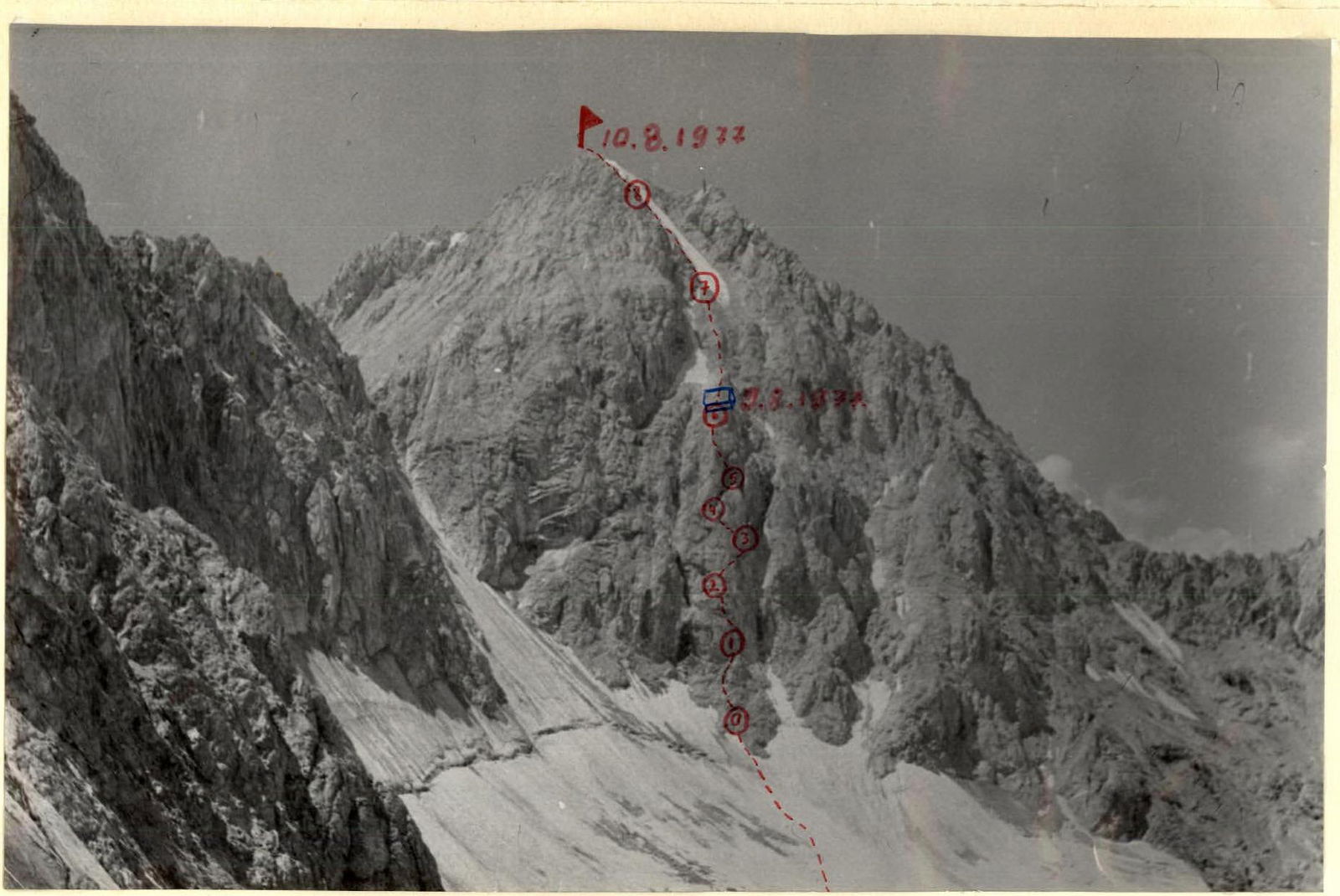 General view of the route.
The approach from the base camp in the "Podkovy kosmonavtov" glacier cirque to the route takes 3 hours. The route goes through the central bastion of the NE wall of Peak Nikolaeva, bounded on the left and right by black couloirs with streams. Rocks are constantly falling through the couloirs!!
The ascent begins on a diamond-shaped rocky outcrop bounded on both sides by snowfields.
Section R0–R1. Two ropes — exit to the finger topping the rocky outcrop — medium-difficulty rocks. Length 80 m (category 3 difficulty). (In the following, the category difficulty assessment is done according to the method proposed in the book by Naumov A.F. "Karagum, Digoria, Tsey", Fizkultura i Sport publishing house, 1976). Go around the finger on the left, belay through outcrops and pitons. 3 pitons driven on the section.
Section R1–R2. Movement from the finger goes left and up feather-like rocks with 70–80° steepness towards a light patch on a background of surrounding dark grey rocks. Above the patch — a ledge, with a control cairn on it. From the finger to the patch — 80 m. Difficult climbing (category 4 difficulty), piton belay. 16 pitons driven.
Section R2–R3. Above the control cairn there are steep, sheer rocks in the form of smoothed walls. Movement goes:
- right and up, bypassing the mirrors,
- towards an overhanging oval rock,
- then into a narrow vertical chimney 5 m long,
- up a smooth, steep wall on the right part of the bastion (category 4 difficulty, 80° steepness, very difficult climbing, artificial holds),
- exit to a narrow ledge — 1 rope from the control cairn.
7 pitons driven on the section.
Section R3–R4. From this ledge, movement goes right to left and up (to the left part of the bastion). Rocks are of the "ram's forehead" type — strongly wind-eroded marbleized limestones. Very difficult climbing using artificial holds. Movement without backpacks. Section steepness 80°. 12 pitons driven (category 5 difficulty), 40 m.
Section R4–R5. We enter a gap under the vertical gendarme of the bastion. Moving along the sheer wall of the gendarme right and up (bypassing the gendarme on the left is rockfall-prone!!) on medium-difficulty rocks (category 3 difficulty, piton belay, 4 pitons driven), we enter the right part of the summit gendarme.
Section R5–R6. The chimney is sheer, with some overhangs. To the right of the chimney — a vertical wall of fine-block structure made of loose rocks. Very difficult climbing using artificial holds, movement without backpacks. Steepness 90°, 13 pitons driven (use box pitons). Category 5 difficulty. After passing the chimney, we enter the edge of the pre-summit gendarme of the bastion and then its summit (30 m, 70–80°, piton belay, 5 pitons driven). Bivouac site!!
Section R6–R7. From the bivouac site, movement goes on medium-difficulty rocks of the "ram's forehead" type. Walls 5–7 m, steepness 60–70°. Many loose rocks. Belay through outcrops and pitons. From the bivouac site to the turn of the snow-ice couloir descending from the summit — 4 ropes. Section steepness 45–50°, 12 pitons driven (category 3 difficulty).
Section R7–R8. At the turn of the couloir, we move to the left rocky side of the snow-ice couloir. Rocks with 70–80° steepness, very destroyed, tense climbing, piton belay. Category 4 difficulty. Ice in the couloir is exposed in the middle part, rocks are falling!! Movement goes along the boundary between ice and rocks, on medium-difficulty rocks, piton belay and through outcrops. Rocks are destroyed, rockfall-prone. Total length of the section — 120 m, 17 pitons driven.
Section R8–R9. Then we need to move deeper to the left rocky side of the ice couloir, which is a pronounced ridge leading to the summit. Rocks with 69–70° steepness, some walls 5–7 m. Piton belay. 7 pitons driven. Category 3 difficulty. Section length 80 m.
Descent from the summit along the northern ridge. The ridge is extremely destroyed, rockfall-prone!! Tense climbing, 5 sport routes set during descent. From the shoulder of the lower part of the ridge, descent goes along talus ledges to the glacier below the summits of Peak Nikolaeva and Peak Popovich.
Approach to the route takes 3 hours, bastion — 10 hours, from bivouac site to summit — 5 hours, descent from summit to glacier — 5 hours and to camp 1 hour.
Table of technical characteristics of the route via the central bastion of the NE wall of Peak Nikolaeva
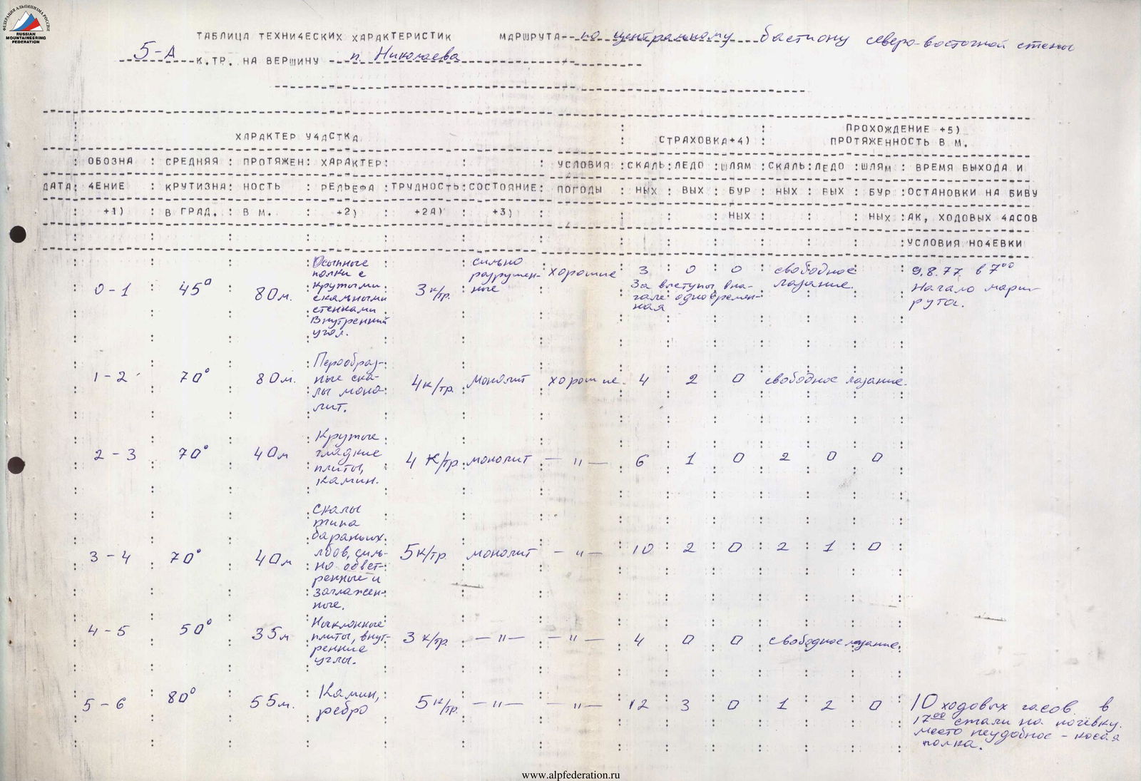
| Section (Designation) | Steepness (in degrees) | Length (in m) | Terrain characteristics | Difficulty (category) | Condition (terrain) | Weather | Belay (driven: rock/ice/bolt) | Belay (exit: rock/ice/bolt) | Notes (Exit time, bivouac, overnight stay) |
|---|---|---|---|---|---|---|---|---|---|
| R0–R1 | 45° | 80 | Talus ledges with steep walls, inner corner | 3 | Highly destroyed | Good | 3 / 0 / 0 | 0 / 0 / 0 | August 9, 1977, 7:00, start of the route. |
| R1–R2 | 70° | 80 | Feather-like rocks, monolith | 4 | Monolith | Good | 4 / 2 / 0 | 0 / 0 / 0 | Free climbing. |
| R2–R3 | 70° | 40 | Smooth slabs, chimney | 4 | Monolith | — | 6 / 1 / 0 | 2 / 0 / 0 | — |
| R3–R4 | 70° | 40 | Rocks of "ram's forehead" type, strongly wind-eroded and smoothed | 5 | Monolith | — | 10 / 2 / 0 | 2 / 1 / 0 | — |
| R4–R5 | 50° | 35 | Inclined slabs, inner corners | 3 | — | — | 4 / 0 / 0 | 0 / 0 / 0 | Free climbing. |
| R5–R6 | 80° | 55 | Chimney, edge | 5 | — | — | 12 / 3 / 0 | 1 / 2 / 0 | 10 hours of climbing. At 17:00 stopped for overnight stay. Uncomfortable site – ledge. |
| R6–R7 | 45° | 160 | Ledges, inner corners, small walls | 3 | Rocks destroyed, many rocks | Good | 10 / 2 / 0 | 0 / 0 / 0 | Free climbing, August 10, 1977, 7:30, continued movement. |
| R7–R8 | 50° | 120 | Rocks of block structure, small walls | 4 | Rocks destroyed, many loose rocks | — | 16 / 1 / 0 | 0 / 0 / 0 | — |
| R8–R9 | 45° | 80 | — | 3 | — | — | 7 / 0 / 0 | 0 / 0 / 0 | Reached the summit at 12:35 |

