Ascent Passport
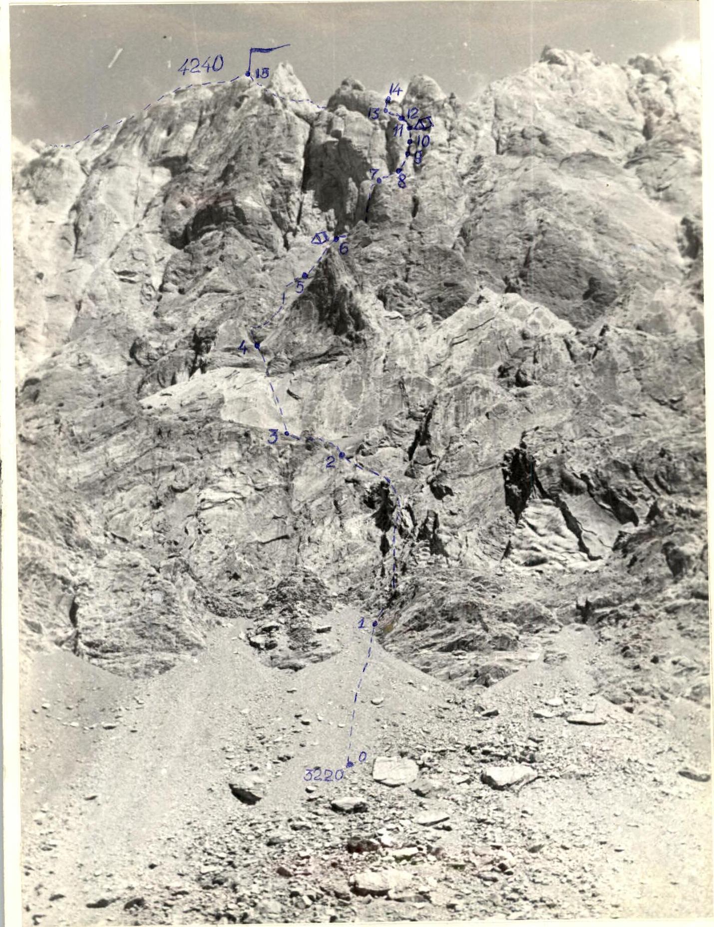
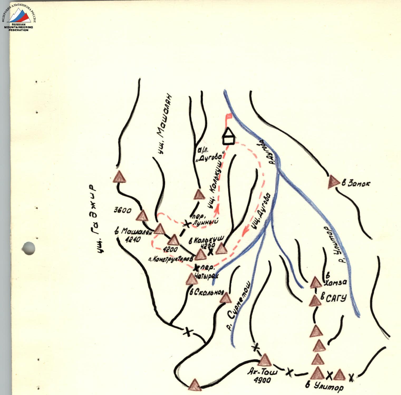
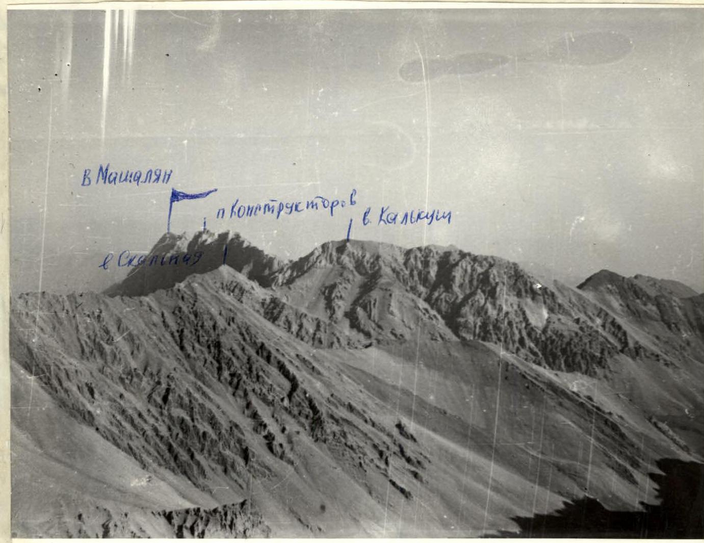
I. Class: rock 2. Ascent area: Pamir-Alay, Alay Ridge 3. Ascent route: Mashalyan peak via South wall 4. Difficulty category: 5B 5. Route characteristics: height difference: 1020 m length of sections 5–6 difficulty cat.: 890 m average steepness: 70°
-
Pitons hammered: for belay — rock 56, chocks 48; for creating ITO — rock 5, chocks 5.
-
Travel hours: 28 h
-
Number of nights and their characteristics: two bivouac nights
-
Surname, name, patronymic of the leader, participants, and their qualification: Kolotiy Valery Ivanovich CMS Bayakin Sergey Gennadievich CMS Laptyonok Valery Dmitrievich CMS Sapozhnikov Yuri Georgievich CMS
-
Team coach: Yakovlev Vitaly Dmitrievich MS USSR
-
Date of departure and return: departure: July 15, 1978 return: July 17, 1978
 www.alpfederation.ru↗
 www.alpfederation.ru↗
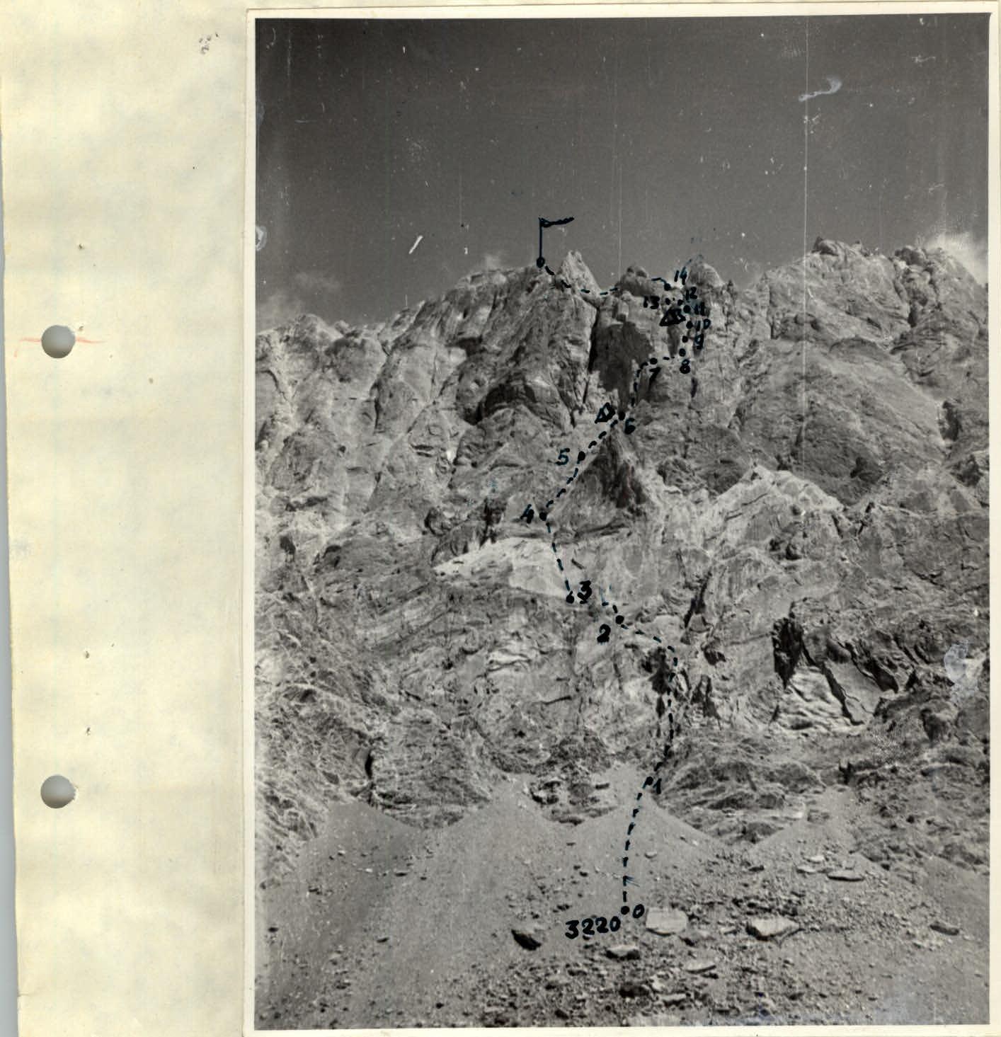
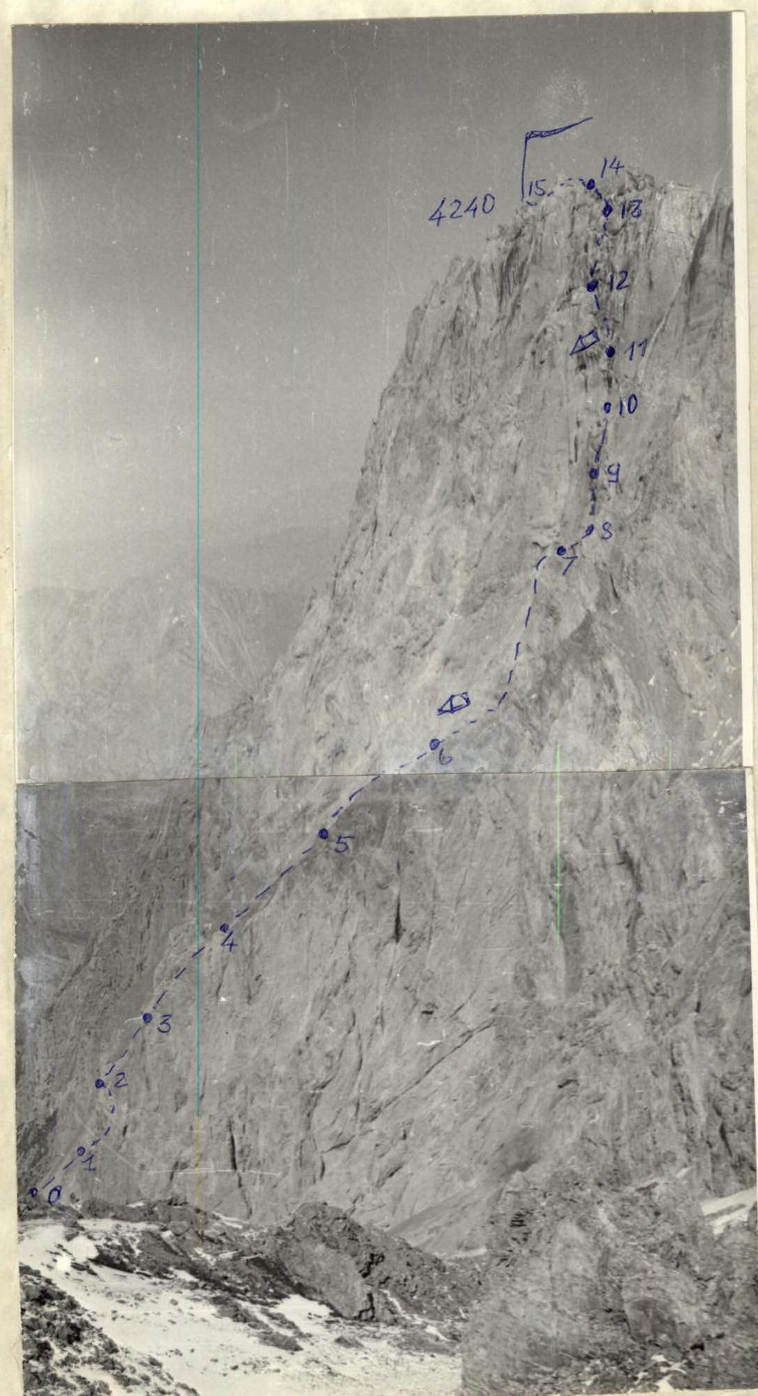
Table of main characteristics of the ascent route to Mashalyan peak via South wall
Route length: 1290 m. Height difference: 1020 m. Average steepness: 70°.
Section characteristics:
| Date | Section |  Avg. steepness Avg. steepness |  Length Length |  Terrain character Terrain character | Difficulty cat. | Condition | Weather conditions | Rock Pitons | Ice Pitons | Chocks Pitons | Bolt Pitons |
|---|---|---|---|---|---|---|---|---|---|---|---|
| 15.07 6 h | R0–R1 | 35° | 100 m | scree | 1 | loose | clear | – | – | – | – |
| R1–R2 | 45° | 80 m | rock | 4 | loose | -"- | 4 | – | 2 | – | |
| R2–R3 | 40° | 80 m | scree | 1 | -"- | -"- | – | – | – | – | |
| R3–R4 | 60° | 210 m | rock | 5 | monolith. | -"- | 8 | – | 12 | – | |
| R4–R5 | 55° | 200 m | rock | 5 | -"- | -"- | 6 | – | 6 | – | |
| 17 h | R5–R6 | 75° | 120 m | rock | 5 | -"- | -"- | 10 | – | 2 | – |
| 16.07 6 h | R6–R7 | 90° | 60 m | rock | 6 | -"- | -"- | 6 | 1 | 4 | – |
| R7–R8 | 70° | 40 m | rock | 5 | -"- | -"- | 4 | – | – | – | |
| R8–R9 | 80° | 40 m | rock | 6 | -"- | -"- | 4 | – | 2 | 1 | |
| R9–R10 | 90° | 80 m | rock | 5 | -"- | -"- | 6 | – | 3 | – | |
| 18 h | R10–R11 | 90° | 40 m | rock | 6 | -"- | -"- | 2 | – | 4 | – |
| 17.07 6 h | R11–R12 | 85° | 50 m | rock | 5 | -"- | -"- | 2 | – | 4 | – |
| R12–R13 | 70° | 50 m | rock | 5 | -"- | -"- | 3 | – | 2 | – | |
| R13–R14 | 50° | 40 m | rock | 4 | -"- | -"- | 1 | – | 1 | – | |
| R14–R15 | 40° | 120 m | rock | 4 | -"- | -"- | 1 | – | 2 | – |
Brief explanation of the table
R0–R1 Non-hazardous scree slope. R1–R2 Broken rocks. Up 40 m. Left traverse above the wall 40 m. Exit to scree. R2–R3 Scree, simultaneous movement. R3–R4 Large, smooth slabs. Friction climbing. Belay is difficult. Exit to a "nest". R4–R5 Movement through "gutters". Limited holds. Belay via chocks. R5–R6 Smooth walls, alternating with small chimneys. Exit to a ledge. Bivouac. R6–R7 Vertical chimney, narrowing to a crack. Two consecutive overhangs. One is overcome by climbing with careful belay. The second — with the use of ITO. R7–R8 Left-up along the wall, difficult climbing. R8–R9 Vertically up a narrow crack, transition along a smooth wall to the left into another crack. ITO. Very difficult! R9–R10 Chimney 80 m, walls are smooth. Belay is difficult. R10–R11 Wall 40 m. Limited holds. Climbing is very difficult. Use of ITO. Exit to a ledge. Bivouac. R11–R12 Movement through cracks. Exit to a sharp "knife" ridge. R12–R13 Passage along the "knife". Up a wide chimney. Difficult climbing. R13–R14 Up a sloping wall. Exit to a ridge. R14–R15 Movement along the ridge. Absence of outcrops, smooth faces. Belay is difficult. Summit.


