Passport
First ascent to the summit peak 4804 (peak LTI) via the North-Eastern ridge, category 3B (tentative)
- Class — technical
- Climbing area — Pamir-Alay
- Summit, height, ascent route — peak 4804 via NE ridge
- Proposed difficulty category — 3B
- Route characteristics: height difference — 260 m, average slope — 33°
- Pitons driven: for belay — 17 Rock — 17 Ice — Bolts —
- Number of climbing hours — 4–5 h + 3 h (descent)
- Number of nights and their characteristics — none
- Full name of the leader, participants, their qualification:
- Bakurova V.E. — 1st sports category (leader)
- Klementyev M.P. — 1st sports category
- Myachenkov V.S. — 1st sports category
- Rakhimov E.A. — 1st sports category
- Simin V.N. — 1st sports category
- Shevchenko A.A. — 1st sports category.
- Coach — Bakurov V.A., Master of Sports.
- Departure and return date — August 5, 1978.
TABLE OF MAIN CHARACTERISTICS OF THE ASCENT ROUTE

Section characteristics
Pitons
Date Notation Average slope, °
Length, m
Terrain characteristics
Difficulty
Condition
Weather conditions
Rock
Ice
Bolts
R0–R1
15–20
80 m
ridge
1
destroyed
simultaneous
–
–
R1–R2
30
40 m
spur
3
"
ledge +2
–
–
R2–R3
40
30 m
ledges
3
scree
ledges
–
–
R3–R4
15
30 m
small ledges
4
destroyed
5
–
–
August 5, 1978
R4–R5
0
80 m
ledges
2
"
Clear
ledges
–
–
R5–R6
40
50 m
edge
5
"
Clear
2 + ledges
–
–
R6–R7
75
40 m
wall
4
Monolith
Clear
5
–
–
R7–R8
45
50 m
slabs
3
destroyed
3
–
–
33°
400 m
Descent via the ascent route.
Ascent route to peak 4804 (peak LTI) via the North-Eastern ridge
Description
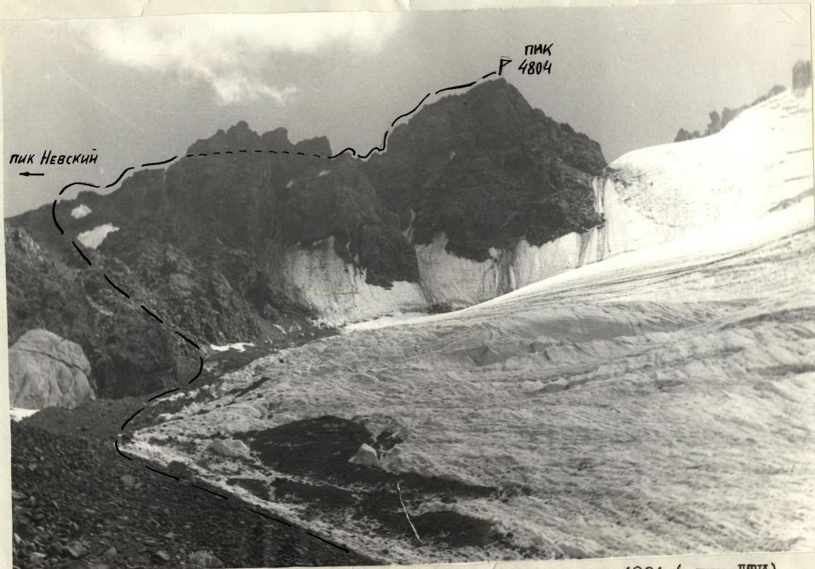
approach to the route to peak 4804 (peak LTI) via the NE ridge, category 3B.
Exit from the base camp via "debris", up the Surmetash gorge, and then, after fording the river, we ascend the Surmentash gorge. After the waterfall, the cirque of peak 4804 opens up. Approximately 1.5–2 hours from the camp.
Ascent via scree. The scree has a characteristic yellowish-red color. After 1 hour of ascent, a view of the glacier flowing from the ridge of peak 4804 opens up.
Ascent via the left lateral moraine of the glacier. Scree.
After 1.5 hours of ascent, a scree couloir begins to the left of two snow patches.
The couloir leads to the ridge, where the route begins.
From the base camp under the "debris" to the ridge, approximately 5–6 hours.
Description
route to peak 4804 (peak LTI) via the NE ridge. Two ropes of simple, destroyed ridge lead to a small spur (R0–R1), which is bypassed on the left. Then ascent to the right and traverse under the wall via scree ledges (R1–R2). Belay is alternating. Caution, rocks are destroyed! Further ascent via an inclined scree ledge with a slope of about 40°, 30 m (R2–R3), and then a complex traverse via narrow ledges — 30 m (R3–R4). Piton belay. The ledges lead to a gap in the ridge.
Then, bypassing a gendarme on the left, we descend into a gap between the gendarme and the summit tower (R4–R5). Caution — scree ledges! Ascent via the destroyed ridge to the summit tower (R5–R6). Then via a steep wall, about 75° (R6–R7). The overhanging part of the wall is bypassed on the right via slabs. Piton belay! Then via slabs — exit to the summit (R7–R8).
The entire route from the ridge connection to the summit takes about 4–5 hours. Descent via the ascent route. During descent, some sections should be straightened using sport rappels. Descent from the summit takes 2–3 hours.