№ 352 dated April 25, 1972
Location of the summit
The summit "Kashak-su" 4125.9 m is located in the left half of the "Kaindy" ridge, which stretches in the latitudinal direction parallel to the Fergana ridge (Fig. 1). It is the highest point of this ridge.
To the west from the summit, a relatively even long ridge descends, sharply dropping to the Kara-kol river, with the Ayry-tash pass (3200 m). To the east, there are two lower summits. They are followed by a long even ridge, which again gains height in the upper reaches of the Kara-kol river. Here is located the summit "Shagal-too" (3900 m). Further to the east, there are two more summits interesting for climbers: peaks 4125 and 4075 m. These summits have hanging and regenerated glaciers from the north. Peak 4075 m sharply drops into the Kara-Ungur river gorge.
At the point of the drop, there are many short and beautiful sairs, overgrown with Tien Shan spruce at the bottom, and filled with ice and snow in the upper part. Adjacent to this summit is a horseshoe-shaped ridge, turning into the gentle Isfan-Jailoo ridge.
The "Kaindy" ridge is formed by dense limestone and partially by schist. The northern slopes drop off with a smooth wall, while the southern slopes are more destroyed and abound with couloirs and scree.
The summit is the longest gendarme extending from the main ridge. The cairn is located on a rocky site of the gendarme and is visible from afar. At the summit, a note was found from the Ovchinnikov group, who made the ascent via the northern ridge, category 3B.
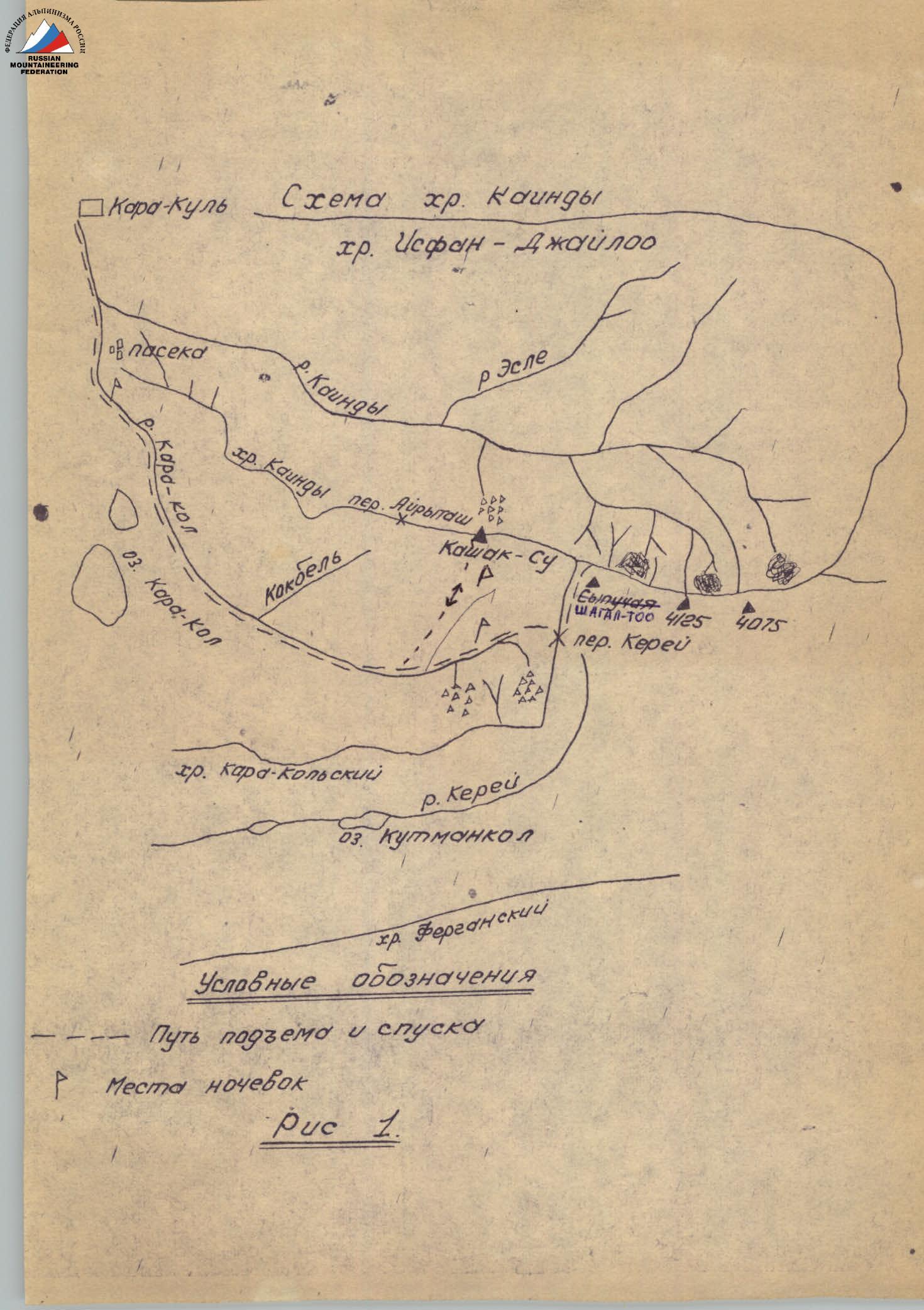 Fig. 1.
Access routes
The starting point for accessing the area of the "Kashak-su" summit is the Kara-Kul settlement, located on the Frunze-Osh highway (Kyrgyz SSR). From the settlement, a dirt road goes past the gravel plant along the Kara-kol river to Chon-tash (Big stones). The distance from the settlement to the stones is 4 km.
Next, you need to use a pack trail that runs along the Kara-Kol river. The trail starts from the stones and goes along the riverbank. Twenty minutes walk from Chon-tash, a fairly beautiful gorge begins. The trail is partially laid along the slopes, ravines, and crosses from one bank to the other twice.
At the end of the gorge, the river makes a sharp turn to the east and leads to a beautiful clearing where a good bivouac can be set up. The journey from "Chon-Tash" to the clearing takes 3 hours.
At the end of the clearing, the trail makes a steep ascent below the Karakol lake and near the lower yurts returns to the river again. The journey from the clearing to the yurts takes 1.5-2 hours.
Fifteen minutes walk from the yurts, the trail crosses a bridge to the right bank, and after another 15 minutes, there is a sheepfold, and further, an hour from the first sheepfold to the left of the trail, there is a second sheepfold.
Near the sheepfold, a stream flows into the river. The path to the summit goes along this stream, which in 10 minutes from the sheepfold runs to the right. A landmark for further movement is two rocky outcrops standing separately from the main rocky ridge "Kaindy". The journey to the rocks takes 3 hours.
Description of the ascent route from the overnight stay to the summit
The ascent route is shown in Fig. 2. From the camp, follow along the rocks in the direction of the large couloir leading to the saddle. The average steepness is 45°. Due to avalanche danger, go along the rocks to the left. Lateral couloirs are crossed in the upper part on snow in three pitches.
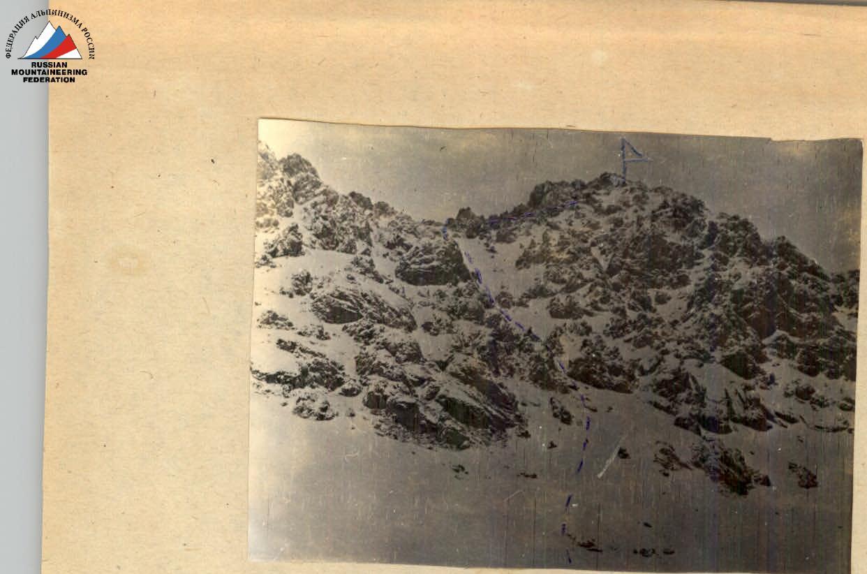 Fig. 2.
Before reaching the ridge, the slope is ascended strictly "head-on" followed by traversing the slope under the rocks. The steepness increases in places to 50-55°. Belay with an ice axe. The ascent time from the overnight stay to the ridge is 2 hours 30 minutes.
From the saddle, move along the eastern ridge. 40 m from the saddle, the path passes through a forked gendarme. Belay through a ledge.
After 50 m of uncomplicated climbing, we approach the second gendarme. The ascent is via a weakly expressed couloir, in the middle of which there is a 4 m wall composed of heavily destroyed rocks. Belay through a ledge.
The further path is to the right (Fig. 3, 4). Along the way, a wall is traversed along a narrow rocky ledge 10-15 cm wide and 8 m long (Fig. 5).
 Fig. 3.
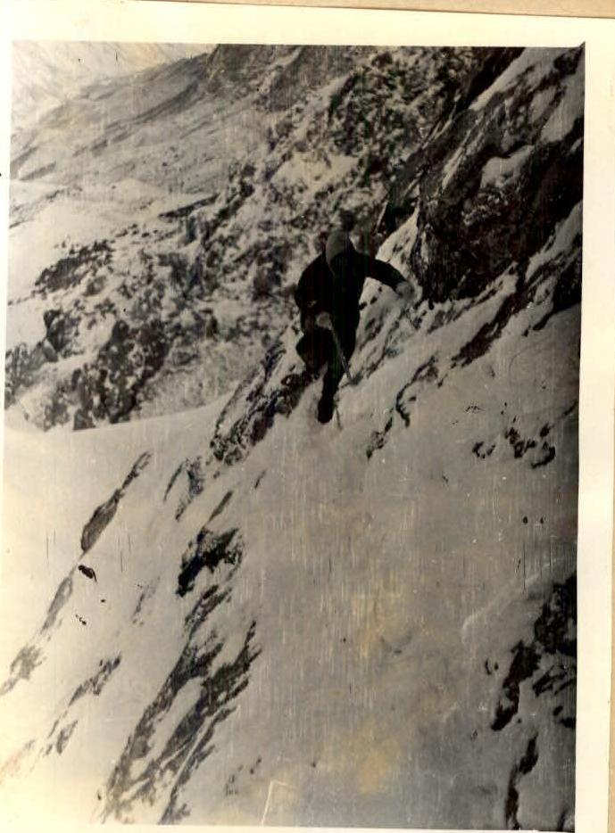 Fig. 4.
After the ledge, ascend a steep snowslope (up to 60°) for 80 m, then a short traverse under the rocks, and where the rocks drop off as a wall to the south, exit left onto the ridge via a rocky wall of medium difficulty. The wall height is 40 m. Belay through ledges and pitons (3 pitons) (Fig. 6).
Next, go 40 m along the sharp ridge followed by a descent into a dip. Two small walls (3 and 5 m) on the descent into the dip are climbed with top-rope belay through ledges.
After the second wall, descend another 3 m to the south along an internal corner and traverse along slabs to exit onto a wide destroyed ridge.
The further path: along the scree, bypassing the black gendarmes to the right, to a passage through a couloir between the second and third gendarmes. Having ascended to the ridge, descend to the north along the scree for 25 m. Turning north, go along rocks of medium difficulty in the direction of the cairn, visible from the passage between the gendarmes.
The highest point is a small elevation like a gendarme, offset from the main ridge to the north (Fig. 7).
The journey from the saddle to the summit takes 4 hours. Descent from the summit is possible directly to the south via couloirs with infrequent rocks. In winter, during heavy snow, it is better to descend via the ascent route.
For the ascent to the summit, it is recommended to have the following equipment for a group of 4-5 people.
- Main rope 2 × 40 m.
- Hammers 2 pcs.
- Carabiners 3 pcs.
- Rock pitons 5 pcs.
The time expenditure was as follows: approaches — 11 hours, ascent to the summit and descent — 9 hours 30 minutes.
The description was compiled by I. Morozov.
Group composition
Leader — Balinsky A.P. (CMS) Participants:
- Nasonova V.T. (MS)
- Nasonov A.G. (3rd sports category)
- Morozov M.V. (3rd sports category)
- Blinova A.I. (3rd sports category)
The group considers that the route passed can be classified as a category 2A route in summer and category 2A in winter. This route is technically more complex and interesting than category 2A routes to the "Uzlovaya", "Zapadnaya", and "Korona" (second tower) summits in the area of the "Ala-Archa" alpine camp, with the only difference being that the "Kashak-Su" summit is lower than the "Korona" (second tower) summit.