Koshak-Su, from the south, 4125.9 m. 153, p/p No. 352 dated 25/4–727
Location of the summit
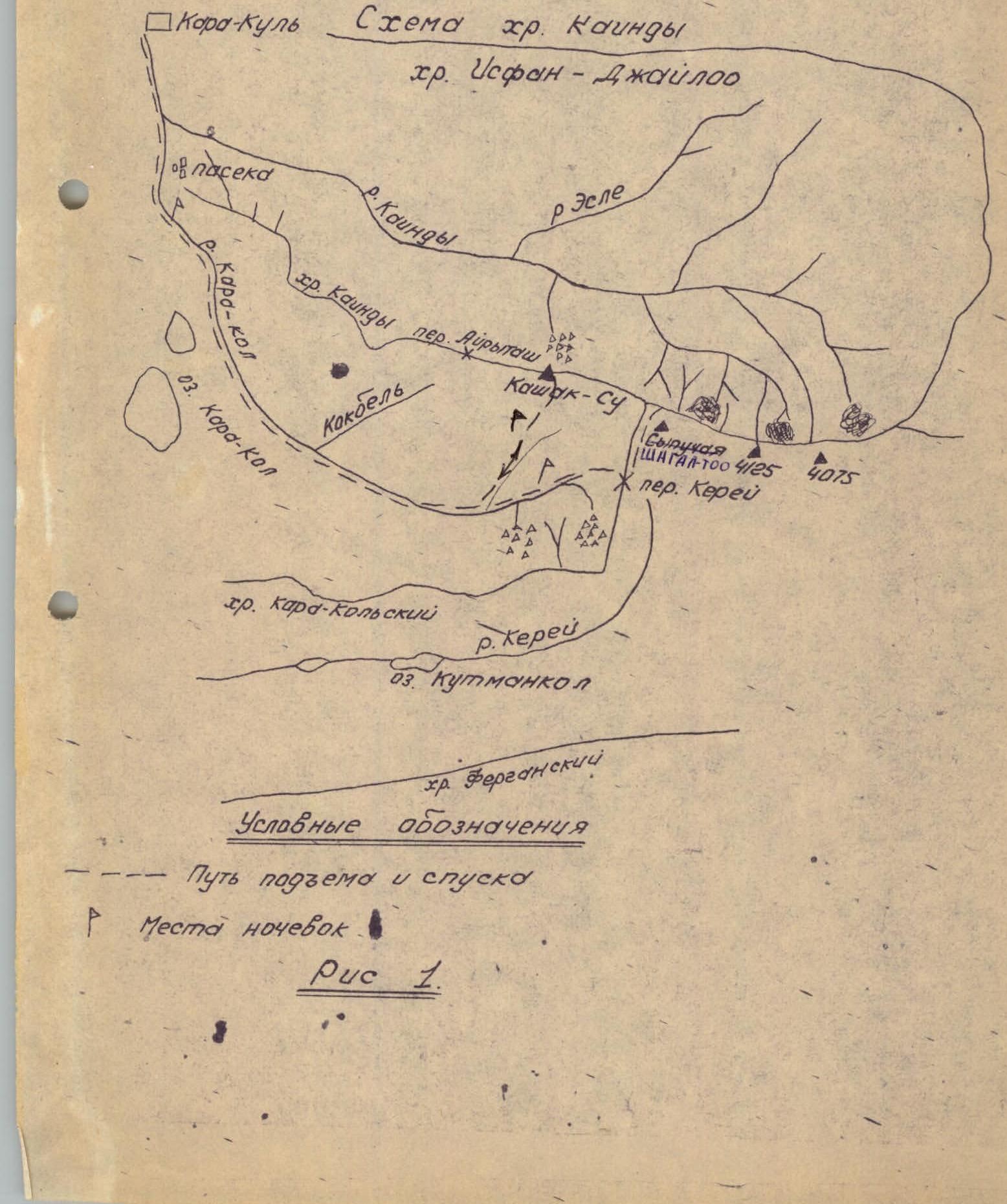
- The summit "Koshak-Su" 4125.9 m is located in the left half of the "Kainды" ridge, stretching in the latitudinal direction parallel to the Fergana ridge. It is the highest point of this ridge (Fig. 1).
To the west of the summit, a relatively even long ridge descends, sharply breaking off to the Kara-kol river, with the Ayry-tash pass (3200 m). To the east, there are two lower peaks. They are followed by a long even ridge, which again gains height in the upper reaches of the Kara-kol river. Here is located the summit "Shagaa" (3900 m).
Behind it, to the east, there are two more peaks interesting for climbers – peaks 4125 and 4075. These peaks have hanging and regenerated glaciers from the north. Peak 4075 sharply breaks off into the gorge of the Kara-Ungur river.
At the point of the break, there are many short and beautiful sairs, overgrown at the bottom with Tien Shan spruce, and filled with ice and snow in the upper part. Adjacent to this peak is a horseshoe-shaped ridge, turning into the gentle Isfan-Jayloo ridge.
The "Kainды" ridge is formed by dense limestone and partially by schist. The northern slopes break off with a smooth wall, the southern slopes are more destroyed and abound with couloirs and scree.
The summit is the farthest along the route and is a jandarm deviating from the main ridge. The cairn is located on the rocky site of the jandarm and is visible from afar. At the summit, a note was taken from the group of Ovchinnikov, who made the ascent along the northern ridge of category 3B.
Access routes
The starting point for the approach to the "Kashak-Su" summit area is the Kara-Kul settlement, located on the Frunze-Osh highway (Kyrg. SSR). From the settlement, a dirt road runs past the gravel plant along the Kara-kol river to Chon-Tash (Big stones). The distance from the settlement to the stones is 4 km.
Next, you need to use the pack trail along the Kara-kol river. The trail starts from the stones and runs along the river bank. Twenty minutes' walk from Chon-Tash, a rather beautiful gorge begins. The trail is laid in some places along the slopes, gullies, and twice crosses from one bank to the other.
At the end of the gorge, the river makes a sharp turn to the east and leads to a beautiful clearing where you can set up a good bivouac. The journey from "Chon-Tasha" to the clearing takes 3 hours.
At the end of the clearing, the trail makes a steep climb below the Kara-Kol lakes and near the lower kibitkas returns to the river again. The journey from the clearing to the kibitkas takes 1.5–2 hours.
Fifteen minutes' walk from the kibitkas, the trail crosses a small bridge to the right bank, and after another 15 minutes - a kosharа, and then an hour from the first kosharа to the left of the trail - the second kosharа.
From the second kosharа, we follow the trail along the river to the third kosharа (2 hours). 20–25 minutes' walk from the third kosharа, the trail after the stream (Sai), Trena goes steeply upwards (to the north).
Having reached the plateau, you need to move in a northwestern direction to the Sai, along which the ascent continues. In its lower part, it is a rocky gorge, which expands at the top and leads to a terrace overgrown with juniper – a convenient place for an overnight stay.
Description of the ascent route from the overnight stay to the summit
From the overnight stay, exit up the snowy slope steeply upwards (45°) for 100 m, and then traverse to the right under the cliffs. You need to go up along the couloir, which is limited on the right by a rocky ridge going down.
In the middle part of the couloir, there is a rocky wall 2 m high (pass by climbing or with a rope).
150 m above the rocky wall, you should go to the right to the flattened part of the ridge of the rocky ridge. At this point, you need to cross несложные скалы and enter a large adjacent couloir. It leads to the ridge of the watershed ridge. The scree couloir has a steepness of 35–45° and a length of 600 m. The couloir is heavily snowy, avalanche-prone. Movement along the rocks to the left.
The couloir leads to a decrease in the ridge, behind which the summit opens, representing a small elevation like a jandarm, displaced from the main ridge to the north.
The path to it lies along rocks of medium difficulty and the summit itself.
The cairn is located on a small site, breaking off on all sides with rocky walls.
Descent – along the ascent route.
The time from the overnight stay to the summit is 6.5 hours, descent – 2.0 hours.
Description compiled by: I. Morozov
The ascent was made on March 7–8, 1971, by climbers from the Kara-Kul section.
Group members:
- Inozemtsev Yu. Pr. (leader)
- Strelova T. Shr.
- Morozov I. Pr.
The group considers it possible to classify the route taken as category 1B.