Ascent Passport
- Climbing type: rock climbing.
- Ascent area: Tian Shan, Chatkal Ridge.
- Peak, its area and ascent route: Bolshoi Chimgan, 3277 m, West wall of the North ridge.
- Route description: height difference — 1700 m, average steepness — 40°. Length of sections R1–40 m, R2–20 m, R3–25 m, R4–50 m, R5–120 m, R6–40 m, R7–80 m, R8–40 m.
- Proposed category of difficulty: 3A.
- Number of pitons driven: for belaying: rock II. ice — bolt — for creating intermediate belay points: rock — ice — bolt —
- Number of climbing hours: 10 hours.
- Number of nights and their description: one-day ascent.
- Full name of the leader and participants, their sports qualification:
- Kudakaev T.Z. – Climbing leader.
- Mikeeva Z.D. – Climbing.
- Polnova E.I. – 1st sports category.
- Yudin G.E. – Climbing.
- Khursandov A.A. – Climbing.
- Team coaches: Popova I.A. and Tselovakhin V.V.
- Date of departure and return: May 2, 1978.
Route Description
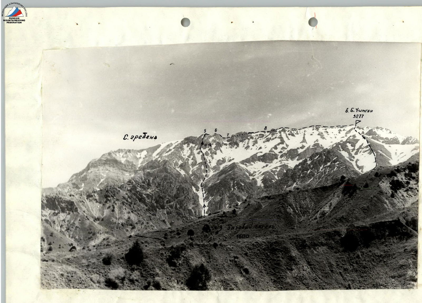
Ascent to peak Bolshoi Chimgan (3277 m) via the West wall of the North ridge, 3A category of difficulty (approximate).
From the base camp located at the foot of the North counterfort of the West ridge of peak Bolshoi Chimgan, the path goes through the Aksai gorge to the fork of the couloirs above the abandoned cable car.
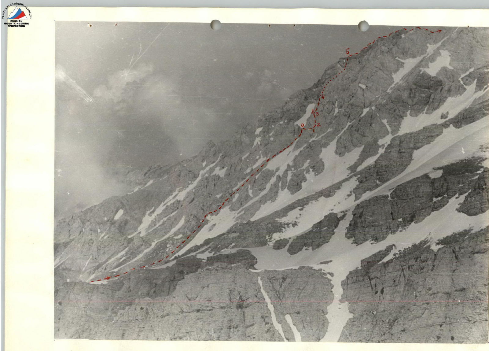
Move up the right snowy couloir, bypassing a large gray rock massif (300–400 m). The steepness of the couloir is 30–40°. Here, there is a convenient exit from the couloir along the easy rock slopes to the left and upwards to the base of a yellow gendarme. The exit and the characteristic gendarme are clearly visible from below. The gendarme is bypassed on the right along the talus and snow. 60 m behind the gendarme, there is a talus col between two couloirs. Behind the col, the wall begins. This is the start of the route. The approach takes 2.5–3 hours.
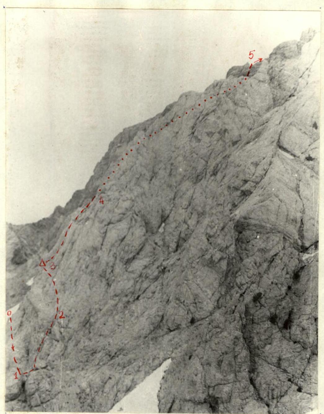
R0–R1
- At the beginning of the ascent, move along an inclined ledge (25–30°) to the right and upwards for 40 m.
- Piton belay (2–3 pitons).
- Exit to a characteristic "window".
- From the "window", 3–4 m down to a ledge with talus.
R1–R2
- From the ledge, straight up (15–20 m) to a rock shoulder.
- The average steepness of the rocks here is about 70°, piton belay (2–3 pitons), holds for climbing are poor.
- On the shoulder, set up a belay.
R2–R3
- Behind the rock shoulder, move left and up for 20–25 m to a sharp rock ridge with a cairn.
- Climbing is of medium difficulty, the steepness of the section is up to 70°.
R3–R4
- Further along the ridge for 10–15 m, and crossing a rock groove, move up the wall for 30–35 m (steepness 70–80°) to a good ledge.
- Belay on the ridge through protrusions, further — piton belay (3 pitons).
- Caution: rocks are fragile!
R4–R5
- From the ledge, move along the left side of the wall, divided by an outer corner.
- After 100–120 m, exit to the North ridge of peak Bolshoi Chimgan.
- The average steepness of this section is 60°, belay through protrusions.
- From the col to the ridge exit takes 3.5–4 hours.
The total height of the wall is estimated at 180 m, its steepness — at 60–65°.
Move along the North ridge to the right, towards peak Bolshoi Chimgan. The ridge is combined, with a smooth gain in height. Its length is about 1000 m. Mainly, move along the ridge simultaneously in teams, on a shortened rope. It is recommended to strictly follow the ridge line when overcoming snowy sections, as the slopes are avalanche-prone. Belay is provided both through the ridge line and through protrusions on rock sections.
In the lower third of the North ridge, there are technically complex rock sections where movement becomes alternating. R5–R6 Approximately 200 m behind the "ridge junction" — a section of steep (50–60°) strongly smoothed monolithic rocks, 35–40 m high. Despite the apparent complexity, it is relatively easily overcome by a system of three inclined ledges, located in a zigzag. At the turning points, there are places for driving pitons. R6–R7 Further movement is along a narrow rock ridge (about 70–80 m), which ends with a so-called "failure", the descent into which passes along slabs with gravel. Here, one has to move with their back to the slope, with careful belay of a partner through a convenient protrusion. The protrusion also allows for rope pulling when descending last. The length of the hazardous section is no more than 15 m. R7–R8 Behind the "failure", movement along the ridge line becomes difficult due to its jaggedness. There is a convenient bypass of the ridge on the left along rock slopes covered with small gravel. The easy but rather hazardous section (movement over a precipice) is about 40 m long. Alternating movement with belay through protrusions is recommended.
Further, the North ridge has no technical difficulties and leads to peak Bolshoi Chimgan. The ascent from the base camp to the summit takes 8–10 hours.
The descent from the summit is convenient along the West ridge, category 1B. The route is wall climbing, comparable in difficulty and nature of work to category 3A — the traditional route along the NW wall, but steeper. The emergence of another similar route in the area is due to the extreme congestion of the NW wall during mass alpinades.
The group of first ascenders estimates the route's difficulty as category 3A.
Norwegian caches in a vacuum. Character of the section!

Character of the Section
| Date | Designation | Average steepness in degrees | Length in meters | Terrain character | Difficulty | Condition | Weather conditions | rock | ice | bolt |
|---|---|---|---|---|---|---|---|---|---|---|
| 02.05.1978 | R0–R1 | 30 | 40 | rocks | medium | good | good | 3 | – | – |
| R1–R2 | 20 | 20 | " | complex | " | " | 3 | – | – | |
| R2–R3 | 70 | 25 | " | medium | " | " | 3 | – | – | |
| R3–R4 | 80 | 35 | " | complex | destroyed | " | 3 | – | – | |
| R4–R5 | 60 | 120 | " | medium | good | " | – | – | – | |
| R5–R6 | 60 | 40 | " | medium | " | " | 2 | – | – | |
| R6–R7 | – | 80 | " | medium | " | " | – | – | – | |
| R7–R8 | 10 | 300 | " | easy | " | " | – | – | – |