Ascent Passport
- Area: Western Tian Shan, Ugam range, section number according to the 2001 classification table: 7.11.
- Name of the peak: Kyzylbash (4200 m), route name: via the left part of the NE wall.
- Difficulty category: 6A.
- Route characteristics: rock.
- Route elevation gain: 695 m, route length: 755 m, section lengths: 5th difficulty category — 258 m, 6th difficulty category — 207 m. Average steepness: main part of the route — 89°, entire route — 82°, 72°.
- Pitons left on the route: total — 7; including bolted pitons — 2. Pitons used on the route:
| Rock | Bolted | Chocks | Ice |
|---|---|---|---|
| 15*+21/16 | 37*+2/23 | 2*+120/38 | 2 |
* — reuse of previously driven pitons.
- Team's total climbing hours: 28 hours, 2 days.
- Leader: Melnikov Vadim G., Candidate for Master of Sports.
Team members: Prudskikh A., Candidate for Master of Sports; Zhivaev S., Candidate for Master of Sports; Gainulin S., 1st sports category.
- Coach: Benkin Vladimir Samuilovich, Master of Sports.
- Route reconnaissance: August 18, 2001. Ascent start: August 19, 2001. Summit reached: August 19, 2001. Return to base camp: August 20, 2001.
General photo of the summit.
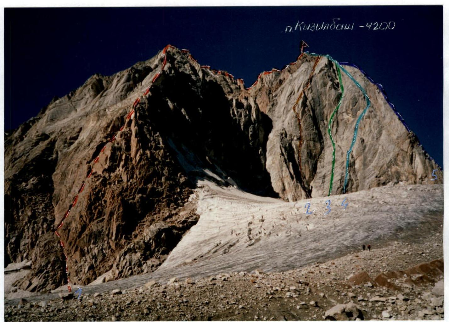
Photo taken on August 17, 2001. Location: glacier in front of the NE wall of Kyzylbash peak.
- Via the NE ridge, 5A (I. Siptak, 1988)
- Route climbed by the team, via the left part of the NE wall, 6A (Sh. Rafikov, 1986)
- Via the NE wall, 5B (A. Timofeev, 1982)
- Via the center of the NE wall, 5B (F. P'yachek, 1988)
- Via the N edge, 5A (V. Dediй, 1986)
Tactical Plan
The Ushba alpine club team was formed during preparations for a training camp in Togliatti, consisting of athletes familiar with joint training sessions.
Before heading to the mountains, team members trained together in the same sports collective. The foundation of their physical training consisted of cross-country runs and hiking trips to the rocks of Samara region. Technique training for rock climbing and rope work was conducted on climbing walls and natural rock formations in Zhiguli Mountains.
The Ugam range area was familiar to some team members from previous training camps.
During the training camp, the team operated according to a developed tactical plan. Several preparatory ascents and first ascents were completed as part of the camp's program, including:
- Ascents in pairs on routes of 5A difficulty category on Druzhba peak (one of the pairs completed a first ascent of a new route);
- On Sayram peak, a 5B difficulty category route was climbed (Starlychanova), and a second ascent was made on a route presumably of 5B difficulty category, previously climbed during the Russian championship by a team from Norilsk.
Consultations on the 6A route ascent on Kyzylbash peak were obtained from a team from Norilsk and Rafikov Sh.R.
According to the developed tactical plan, after a day of preliminary reconnaissance, fixed ropes were set up to the R8 section. The next day, after ascending to the R8 section, the climb continued, and the summit was reached at 23:00.
The bivouac under the summit rocks was in a sitting position. The descent from the summit via the Western ridge and further down to the glacier took place from 6:00 to 10:00 on August 20, 2001.
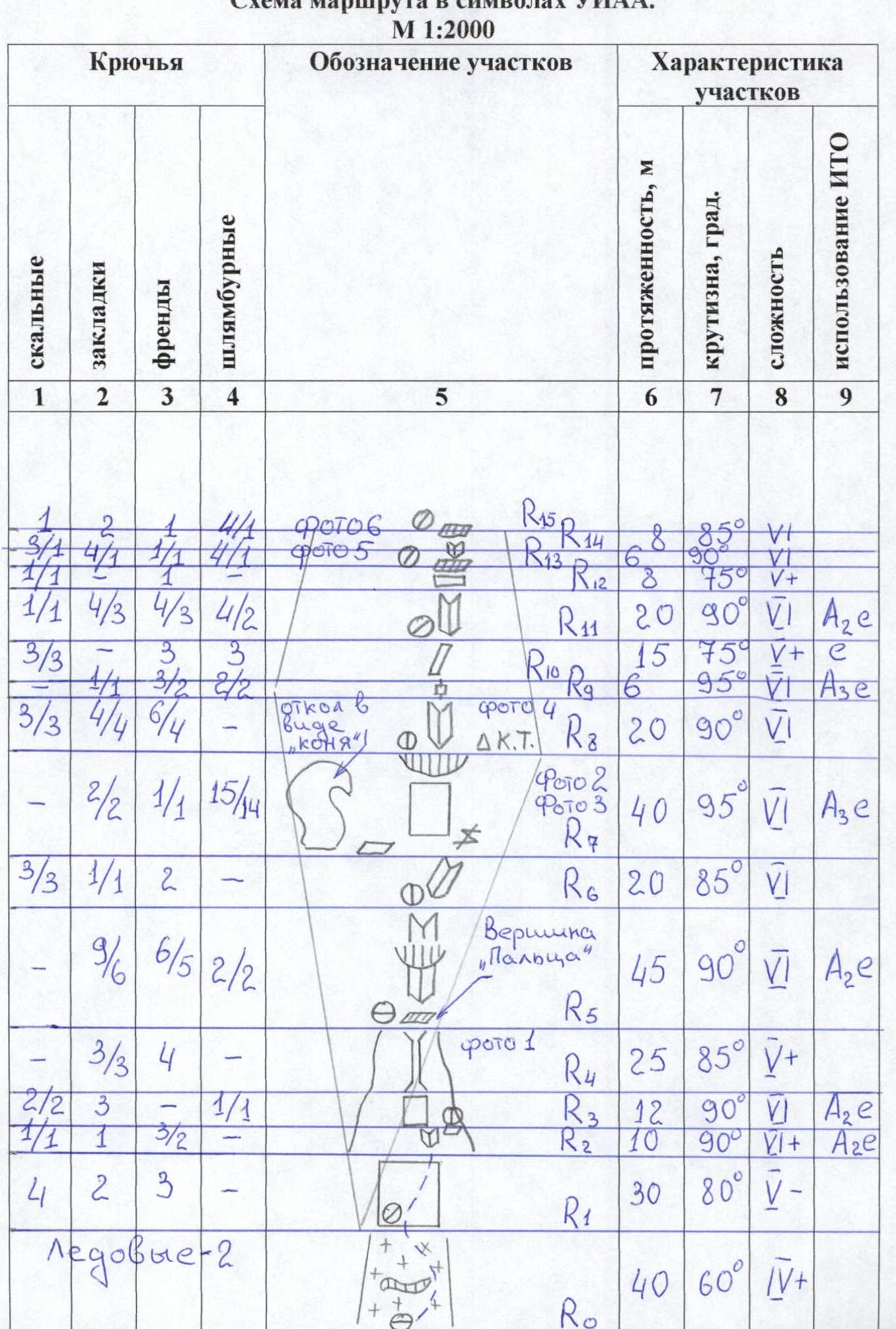
Route scheme in UIAA symbols. Scale 1:2000
| Section | Rock | Chocks | Cams | Bolted | Section description | Length, m | Steepness, ° | Diff. cat. | ITO use |
|---|---|---|---|---|---|---|---|---|---|
| R0 | – | – | – | – | Ice-2 | 40 | 60 | IV+ | |
| R1 | 4 | 2 | 3 | – | 30 | 80 | V- | ||
| R2 | 1/1 | 1 | 3/2 | – | 10 | 90 | VI+ | A2e | |
| R3 | 2/2 | 3 | – | 1/1 | 12 | 90 | VI | A2e | |
| R4 | – | 3/3 | 4 | – | Photo 1 | 25 | 85 | V+ | |
| R5 | – | 9/6 | 6/5 | 2/2 | "Finger" summit | 45 | 90 | VI | A2e |
| R6 | 3/3 | 1/1 | 2 | – | 20 | 85 | VI | ||
| R7 | – | 2/2 | 1/1 | 15/14 | Photo 2 | 40 | 95 | VI | A3e |
| R8 | – | – | – | – | "Horse" detachment ΔK.T. | 20 | 90 | VI | |
| R9 | 3/3 | 4/4 | 6/4 | – | 6 | 95 | VI | A3e | |
| R10 | 3/3 | 1/4 | 3/2 | 2/2 | 15 | 75 | V+ | c | |
| R11 | 1/1 | 4/3 | 4/3 | 4/2 | 20 | 90 | VI | A2e | |
| R12 | 3 | 3 | 3 | 6 | 90 | VI | |||
| R13 | 2/3 | 4/1 | 1/2 | 4/1 | Photo 5 | 8 | 75 | V+ | |
| R14 | 1 | 2 | 1 | 4/1 | Photo 6 | 8 | 85 | VI | |
| R15 | – | 2 | 4 | 1 | Rhombus | 70 | 70 | V- | |
| R16 | – | – | 2 | 1 | 30 | 75 | V+ | e | |
| R17 | – | – | 2 | 2 | 10 | 90 | V+ | e | |
| R18 | 2 | 1 | 1 | – | 30 | 70 | V- | ||
| R19 | 2 | 2 | 4 | – | 40 | 75 | V+ | ||
| R20 | 3/1 | 3 | 1 | – | 20 | 90 | VI | ||
| R21 | 7 | 12 | 7 | – | Waterfall | 170 | 60 | IV+ | |
| R22 | – | 4 | 3 | – | 40 | 55 | III | ||
| R23 | – | – | – | – | 19.08.01 | 40 | 55 | III | |
| R24 | – | – | – | – | Kyzylbash peak 4200 m |
Technical photo of the route.
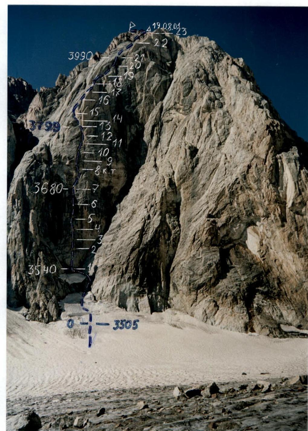
Bivouac on section R23 after the ascent on August 19-20, 2001.
Photo illustration for the report.
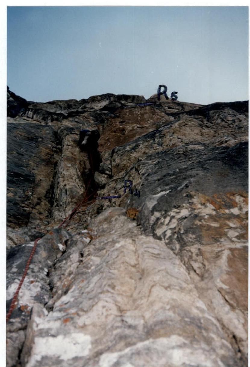
Fig. 1. First participant crosses section 4–5 with a double rope.

Fig. 3. Crossing the fixed ropes on section 7–8.
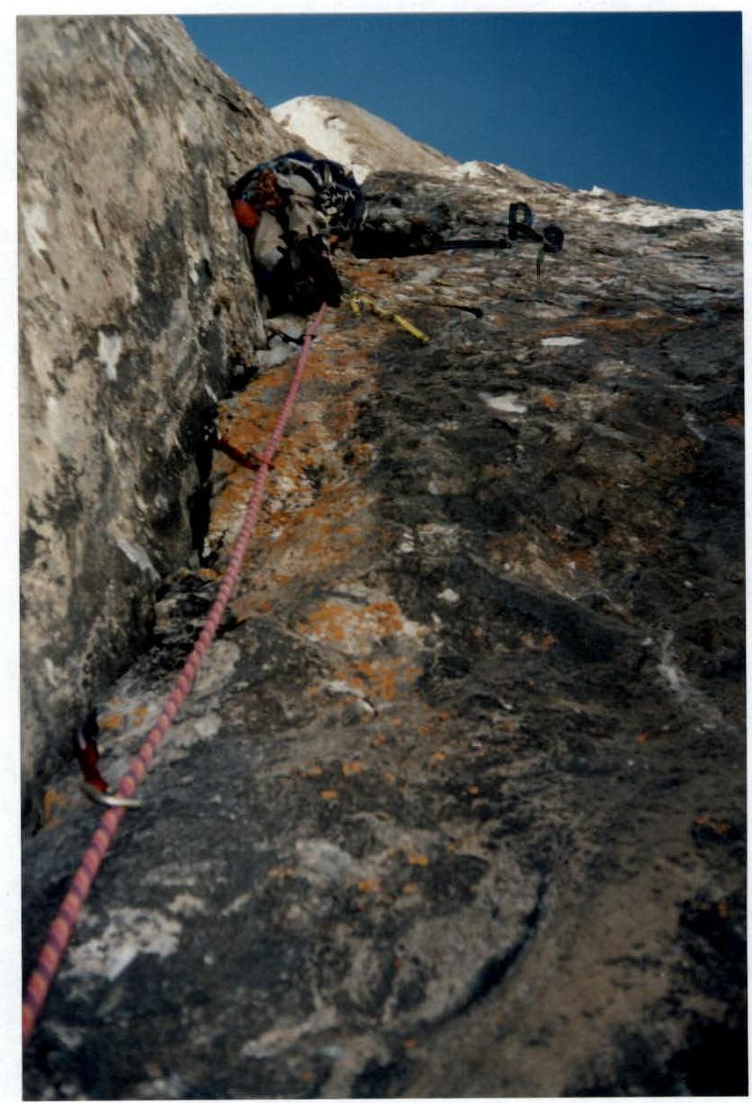
Fig. 4. First participant crossing section 8–9.


