Sayramsky District of the Ugam Range. Ascent to the "Kergely" peak, dedicated to the XIV Congress of the Komsomol. Category 1B. Height 3787.3 m.
You need to leave the bivouac located near the lake as early as possible, because the peak is quite far away (departure at 6:00 am at the latest). Moving along the right side of the ancient moraine, we reach the depression left by the ancient glacier. The approach to the depression takes 1.5–2 hours. From the depression, we ascend directly "head-on" up the steep snowfield, keeping to the left side, to reach easy rock terrain, and, continuing along the rocks or snow (if it's not loose), we reach the first ascent to the pass.
The path from the depression to the end of the first ascent takes 40–60 minutes. Then begins the second ascent along a snowfield with a steepness of 45–50°.
The path from the first ascent to the second takes 30 minutes. After that, we move to the third ascent and reach the pass. As we ascend to the third rise, we need to gradually move to the right towards three rocks protruding with sharp peaks. The entire path from the depression to the end of the third ascent is along the snow and takes one and a half to two hours. By-passing the three isolated rocks from the south, we reach the south-eastern ridge. The further path goes along the south-eastern ridge. The ridge consists of severely degraded rocks with small, loose scree.
At first, the belay is organized alternately, and then, as we move forward, we can move simultaneously with running belay. Severely degraded rocks are circumvented from the south, slightly below, along the loose scree. Having reached the first depression, we descend into it and emerge onto the southern snowy slope. The slope has a steepness of 40–45°.
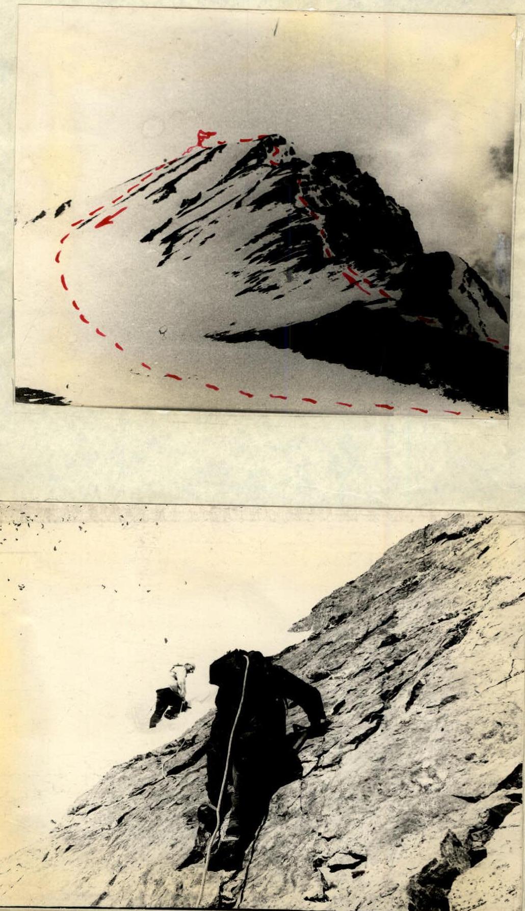
In the upper part, the snowy slope is completely safe from avalanches. By traversing the slope in a westerly direction, we reach slabs covered with small stones. Up the slope, there are small, smoothed-out rocky outcrops, covered with scree. Here, it is necessary to organize belay particularly carefully. The slabs, although not steep (25–30°), are very smooth and have small holds. They are traversed in the lower part with alternate belay.
After the second outcrop, we enter a small (5–7 m wide) couloir with snow walls. We cross it and reach a snowy ascent. Steepness is 60°.
The snow is quite deep and the steps hold well. From this point, the avalanche cones are visible directly below. We ascend the snowy slope straight up to the first ascent, and then to the left (west) to the second ascent. This section of the path takes about 4 hours of work.
Further, the path goes along a gentle snowy slope with small snowy ridges ending in rocky outcrops. Ascending straight up, we reach the subpeak. From the second ascent to the subpeak, the path takes about 50 minutes.
From the subpeak to the peak, a gentle scree slope extends to the south. The path along it to the peak takes 20–30 minutes. When overcoming the slabs, in the absence of good outcrops, it is necessary to drive rock pitons. On snowy ascents, belay can be organized through an ice axe.
The entire path from the pass to the peak takes 5–6 hours. The path to the pass along the snowy slopes must be traversed as early as possible, because by 12:00 pm the snow becomes soggy and the steps do not hold well.
The peak was reached at 14:00. In the lower part, the slope is avalanche-prone, so it is necessary to reach the slabs along the ridge to the depression (25–30 m deep).
The descent is made:
- from the peak to the subpeak
- in a southerly direction.
Under no circumstances should you descend onto the north-eastern slope, as it has a completely vertical wall all the way to the foot. From the subpeak, keeping to the right side, we descend along the snow to small, degraded slabs covered with small stones. During the descent, we traverse these slabs to the left and reach the avalanche cones.
Further, along a gentle snowy slope (30–35°), we reach the lower part of the avalanche cones and, crossing them, we move towards the scree descending from the ridge. Along the edge of the scree and snow, we descend to the pass. The descent is very easy and poses no difficulty. The path from the pass is the same as during the ascent. The descent from the peak to the pass takes 40–50 minutes. The entire ascent takes 10–11 hours. The ascent was made in May 1962.
The route corresponds to category 1B. Description compiled by: (Garshin V.S.)
List of ascent participants:
- Leader: (Garshin V.S.)
- Participants: (Fedotov G.I.), (Kolokolnikov D.V.), (Romanov A.F.)