Ascent Passport
Class: ROCKY Region: TIAN-SHAN, Ugam Range (7.II) Peak: ISHIMBAI Height (by group altimeter): 3590 m Route and proposed category of difficulty: From north to eastern ridge (FIRST ASCENT) 2A category of difficulty, combined Height difference: 400 m Length: 970 m, including 400 m - rocks Average steepness: 40°
No pitons or закладные элементы were used. NO SIGNS of other groups' presence on the eastern ridge of the ascent object were detected.
Number of travel hours: 7.0 Days: one - May 27, 1999
Leader: AGAPFONOV Anat. Kondrat. (1st sports category) + Bryantsev Vladisl. Vladim. (3rd sports category) Signature: Levin Mich. Sem. (Master of Sports of the USSR, 1st category) Muslimov Ziver Iaet. (3rd sports category) Shustov Konst. Vladim. (2nd sports category) Coach: Levin Mich. Sem. (Master of Sports, 1st category)
A) - Departure at 4:00 from the bivouac on the right-bank moraine ridge opposite the ascent couloir, return to the bivouac - at 11:00. Groups repeating the route can depart from the "2320" bivouac on the Green Hill under Mt. Solidarnost.
Photo #39: View from the north to the western spur of p. CHIMKENT (U-99). The same routes as in Photo #38 (p. 25) are shown.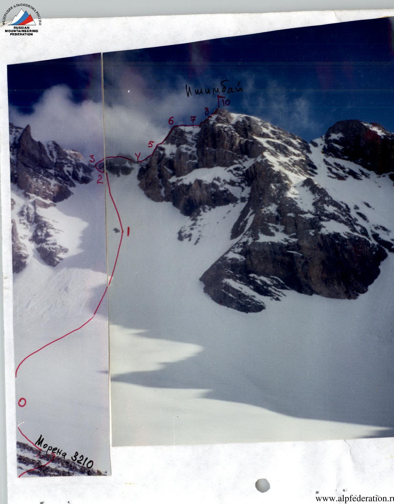
Photo #40-41 - General view of the route: from the north (U-99) and from the east (U-98).
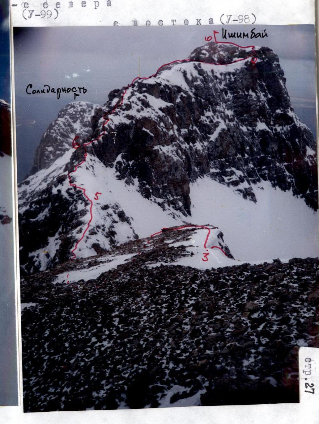
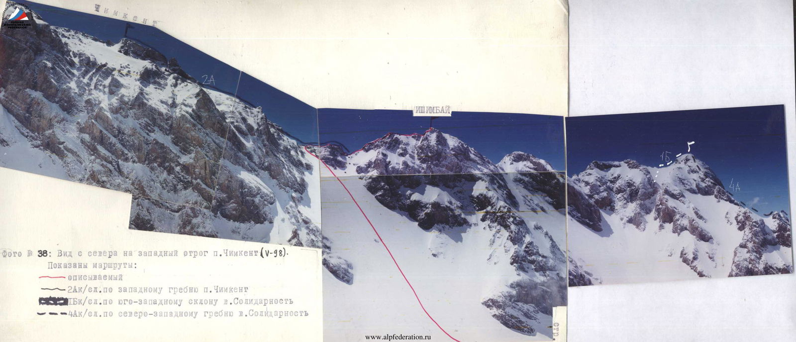
Photo #38: View from the north to the western spur of Mt. Chimkent (V-98). The following routes are shown:
- the described route
- 2A category of difficulty along the western ridge of p. Chimkent
- 1B category of difficulty along the southwestern slope of Mt. Solidarnost
- 4A category of difficulty along the northwestern ridge of Mt. Solidarnost
| Section | Steepness | Length | Character of the section | Notes | Tactics |
|---|---|---|---|---|---|
| 9–10 | 30° | 40 m II | Summit ascent | Destroyed rocks | Simultaneously |
| 8–9 | 25° | 40 m II | Descent into the gap | Destroyed rocks | Alternately through the bend |
| 7–8 | up to 90° | 3 × 40 m II+ | Series of "gendarmes" | The 4th is bypassed on the right, the rest head-on | Alternately through ledges |
| 6–7 | - | 20 m II | Very narrow ridge | Depth of fall up to 20 m | Alternately |
| 5–6 | up to 80° | 30 m I + 3 m II | Ridge with a sheer wall 3 m | Monolithic rocks | Simultaneously through ledges |
| 4–5 | 45° | 70 m II | Ridge ascent | Destroyed rocks | Simultaneously |
| 3–4 | - | 50 m I + 30 m II | Traverse of the "perycka" and descent 30 m | Destroyed rocks | Simultaneously |
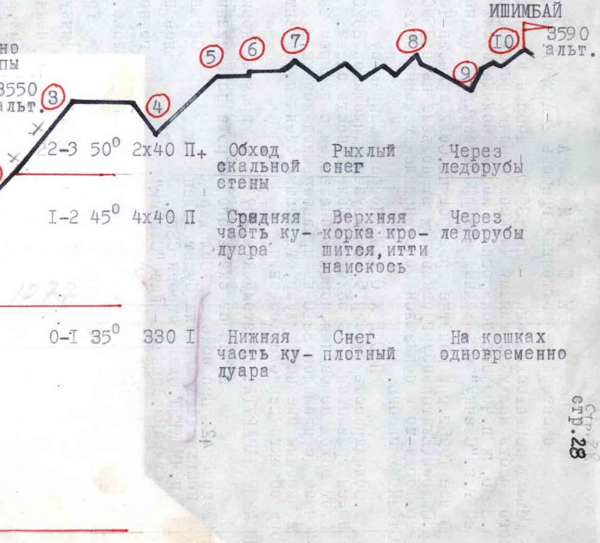
Ishimbai, from north to eastern ridge 2A category of difficulty, combined
The object of the first ascent - peak 3590 - is located in the western spur of the Ugam Range between the peaks Chimkent and Solidarnost (the latter obscures both p. 3590 and p. Chimkent), until, bypassing the Solidarnost massif from the left, you look beyond its so-called "Candle" - the northern counterfort of the northwestern ridge.
In May 1998, during an attempt to traverse pp. Solidarnost-Chimkent (from the south) V.A. Shadrin (Yekaterinburg) abandoned the ascent to p. 3590 and descended to the north. It was then that the path to p. 3590 along the EASTERN ridge seemed more attractive.
APPROACH: Along the Sayram-su River to the "Green Hill" under Mt. Solidarnost (see p. 5). From the base sites 2320 of the "Green Hill" the path bypassing Mt. Solidarnost from the left is not visible.
This detour along scree, moraines, and snowfields with a height gain of about 900 m in 3-4 hours leads to the sites 3210 on the right-bank moraine, just opposite the entrance to the wide snow couloir separating the walls of p. Chimkent from the northern edge of the first ascent object.
ROUTE DESCRIPTION: Up this couloir early in the morning on crampons simultaneously. Then from the rocky island alternately to the saddle.
Photo #42: When bypassing Mt. Solidarnost from the left, p. Chimkent will be visible first. On the left are the spurs of the NW ridge of Sayram, on the right is the low "Candle".
The snow gap to the right of it is 30 m lower than the left one, but the slope to the left is gentler.
Having traversed the saddle and descended into the aforementioned right gap, ascend along the destroyed rocks. Less than 100 m in height to the summit, but more than 300 m of a dissected ridge.
There are two ascents in the ridge, several turns and gaps, a series of low, up to 8 m, "gendarmes". In one place, the ridge narrows to 30 cm.
The summit is clearly defined. No signs of groups.
The name is in honor of the city from which half a century ago the fame of the Bashkir Big Oil began.
DESCENT - along the ascent path.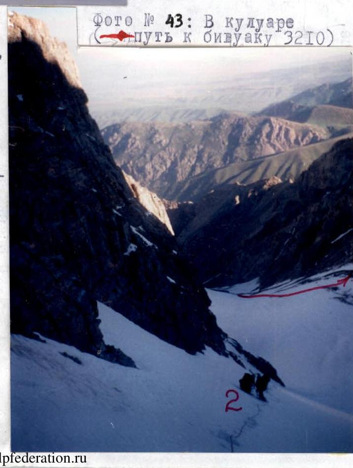
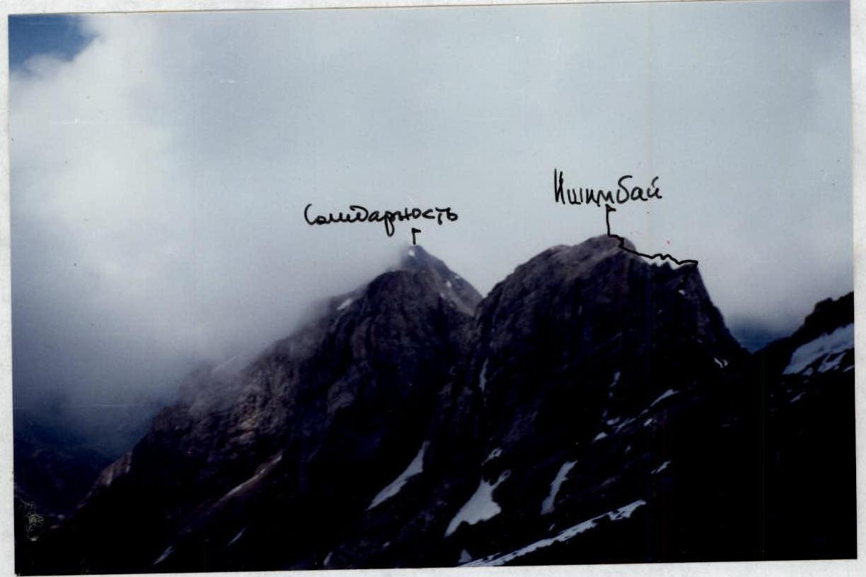
Photo #43: In the couloir (path to bivouac 3210).
Photo #44: View of the peaks Ishimbai and Solidarnost from the southeast, from the slopes of p. Chimkent (U-99).
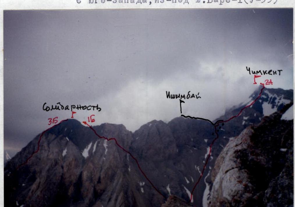
Photo #45: View of the western spur of p. Chimkent from the southwest, from under Mt. Bars-I (U-99).