
Ascent Passport
- Rock class.
- Tashtambek Gorge, Terskey-Alatoo ridge.
- Tash-tuya Peak (Camel), height ~3900 m, Main Peak via South Peak, with ascent to South Peak via East ridge (first ascent)
- Estimated difficulty category - 3B.
- Height difference 500 m, average steepness ~45°
- Pitons hammered for insurance: rock - 9, ice - none.
- Departure and return date: July 24, 1977.
- Number of travel hours - 7.5 hours.
- No overnight stays.
- Participants: Starikov G.A. - CMS, instructor Gorokhov A.A. - 3rd sports category (KSP doctor)
- Coach - Penchuk V.L., Master of Sports of the USSR.
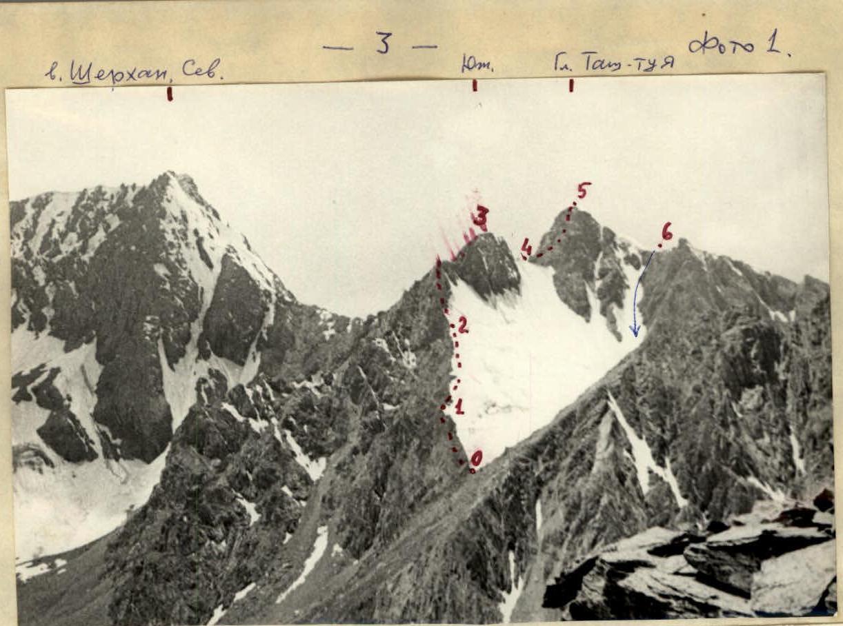 photo 2
Tash-tuya Peak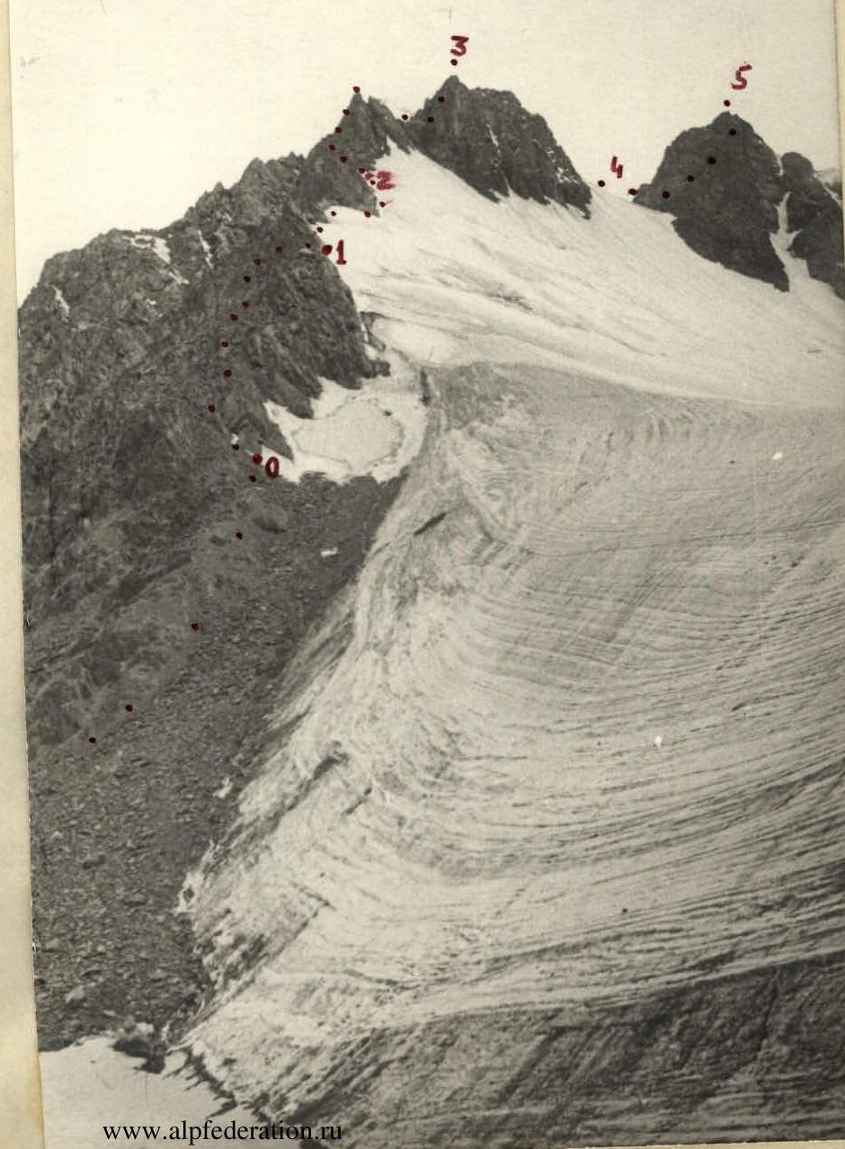
ASCENT DESCRIPTION
Tash-tuya Peak (Camel) with a height of ~3900 m is located in the northern spur of Tashtambektor Peak, to the right of the Sherkhan massif (~4000 m) - see map. This peak was named in 1977. The peak and the entire ascent route are clearly visible from the base camp (photo 1).
The ascent proceeds as follows: from the base camp, located opposite Panorama Peak on the left bank of the Tashtambek River - height approximately 3000 m - along the trail of grassy slopes, then along the moraine of the glacier, approach Tash-tuya Peak and turn into its right cirque, ascend to the eastern ridge of the South Peak Tash-tuya - to the start of the route - 2 hours (photo 2).
Up the steep scree, then along the left side of a simple destroyed ridge, ascent to a convenient platform where it is necessary to form rope teams.
To the left of the ridge, along grassy ledges with simultaneous insurance through existing outcrops, ascent upwards for 100 m and exit to the right onto a rocky ridge - 20 m (point 1).
To the right of the ridge, up a snowy slope, ascent through several muldas for 120 m (point 2).
From here, a convenient exit to the left onto a sharp rocky ridge (~30 m) is visible - 2 rock pitons - along smoothed slabs.
Then:
- steeply upwards 40 m along the left side of the rocky ascent with piton insurance - tense climbing;
- another 40 m ascent with exit to a sharp gendarme under South Peak Tash-Tuya.
At this point, the rocky ridge is broken by two crevices that are impassable. Easier:
- down the first crevice in a chimney, descend and to the left to rocky ledges in a wide couloir - 20 m;
- along these ledges, traverse to the right another 20 m.
From here, the further ascent path to the South Peak is visible:
- first, up a steep internal corner with a large number of loose stones - 40 m;
- then another 60 m up steep rocks with alternating insurance - ascent to South Peak Tash-Tuya (point 3).
From the start of the route - 5-6 hours.
Further descent to the left along ledges - 40 m - with a traverse to the right onto a snowy saddle under the Main Peak (point 4), ascent to which proceeds as follows:
- first 40 m to the right and up along ledges,
- then 80 m up with alternating and piton insurance to the sub-summit.
Along a snowy ridge - 40 m - ascent to the Main Peak Tash-tuya (point 5). From the sub-summit - 2 hours.
Descent from the peak along the NE ridge approximately 2A category of difficulty to the pass (point 6), then to the right down a steep scree couloir for 300 m into the Tash-tuya Peak cirque and further to the start of the route along the glacier, then along the moraine and trail to the base camp - 2 hours.
The total ascent takes approximately 12 hours from the base camp and back. Radio communication was provided by the "Vitalka" radio station. Description compiled by Starikov G.A.
Characteristics of the section
| Date | Designation start | Average steepness in degrees | Length in m | Relief characteristics | Difficulty | Condition | Weather conditions | rock | ice | trail |
|---|---|---|---|---|---|---|---|---|---|---|
| 24.07.1977 | 0–1 | 25 | 200 | rocky ridge | 1–2 | with grass on ledges | sunny | 6 | — | — |
| — | 1–2 | 30 | 120 | snowy slope | 1 | simultaneous | — | — | — | — |
| — | 2–3 | up to 60 | 200 | rocky ridge | 3 | wet | cloudy | 6 | — | — |
| — | 3–4 | up to 60 | 40 | descent | 3 | destroyed snowy | — | 1 | — | — |
| — | 4–5 | up to 60 | 120 | rocky wall | 3 | — | snowfall | 2 | — | — |
| — | 5–6 | up to 30 | 200 | snowy-ice slopes | 1–2 | — | fog | — | — | — |
| — | 6 | total: | 9 |
Comments
Sign in to leave a comment