PASSPORT
-
Climbing category — ROCK CLIMB
-
Climbing area — Tian-Shan, Terskey Ala-Too ridge
-
Peak, height, ascent route: MENDELEEVETS, 4122 m, via CENTER OF THE NORTH FACE TRIANGLE.
-
Difficulty category — 5B (approximate). pr. 588, #6
-
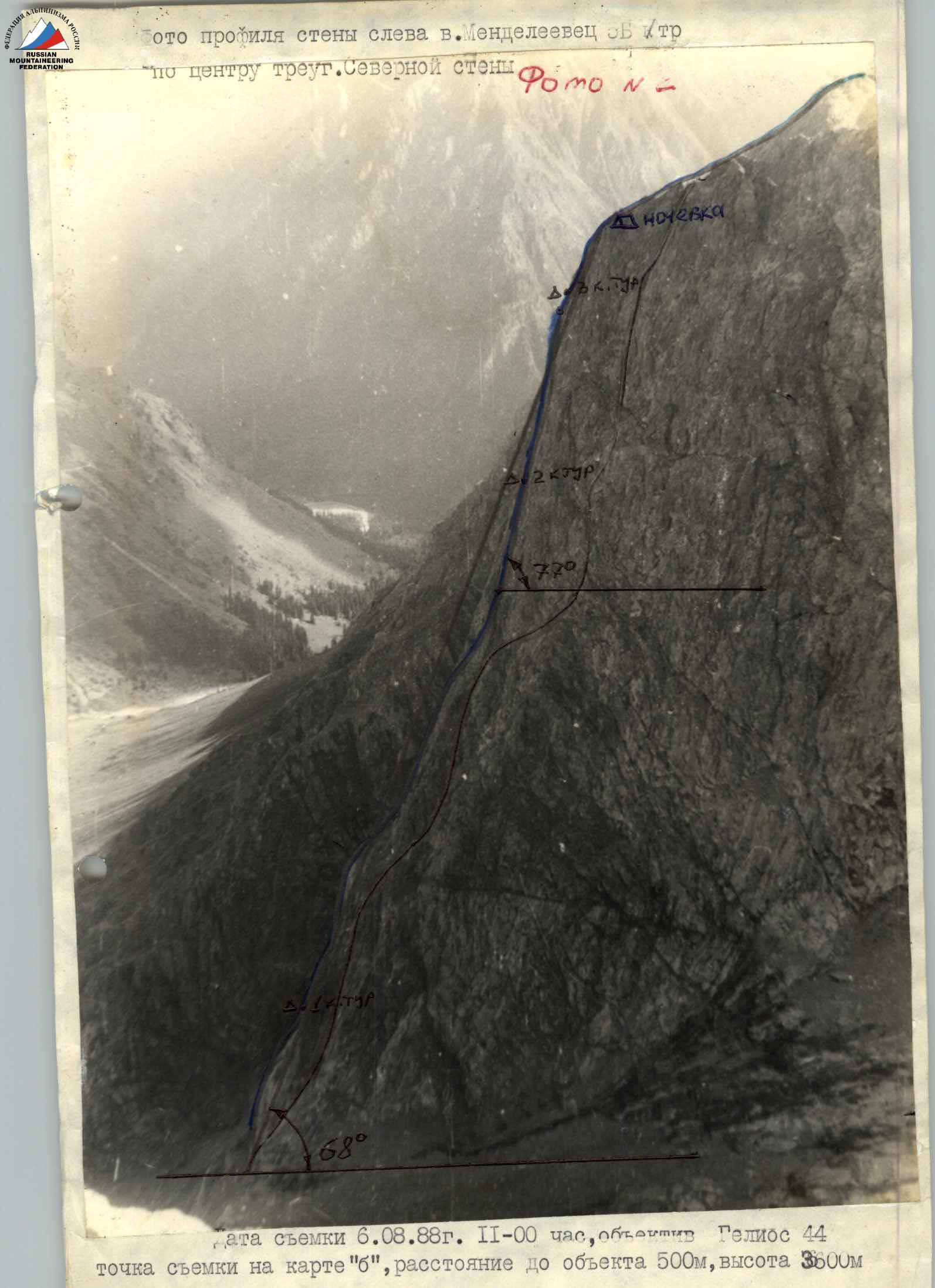
Route characteristics: the wall section of the route is 583 m long, height difference is 1000 m, length of sections with 5–6 difficulty category is 377 m, wall steepness — 68°
-
Pitons used: rock pitons 122/11, chocks 50/4, bolt pitons 2/0
-
Total climbing time — 20 hours, including 15 hours on the wall and 3 days.
-
Number of bivouacs and their characteristics: one lying bivouac in a tent.
-
Team composition:
Team leader:
- Zhmayev Veniamin Vasilyevich — CMS
- Gadeev Ravil Gareyevich — CMS
- Selivanova Nina Nikolayevna — CMS
- Arkhipov Valery Alexandrovich — 1st sports category
-
Team coach: Zhmayev V.V.
-
Route entry: July 12, 1988
Summit — July 13, 1988 Descent — July 13, 1988
-
Organization: KFK "Almaz", Chelyabinsk.
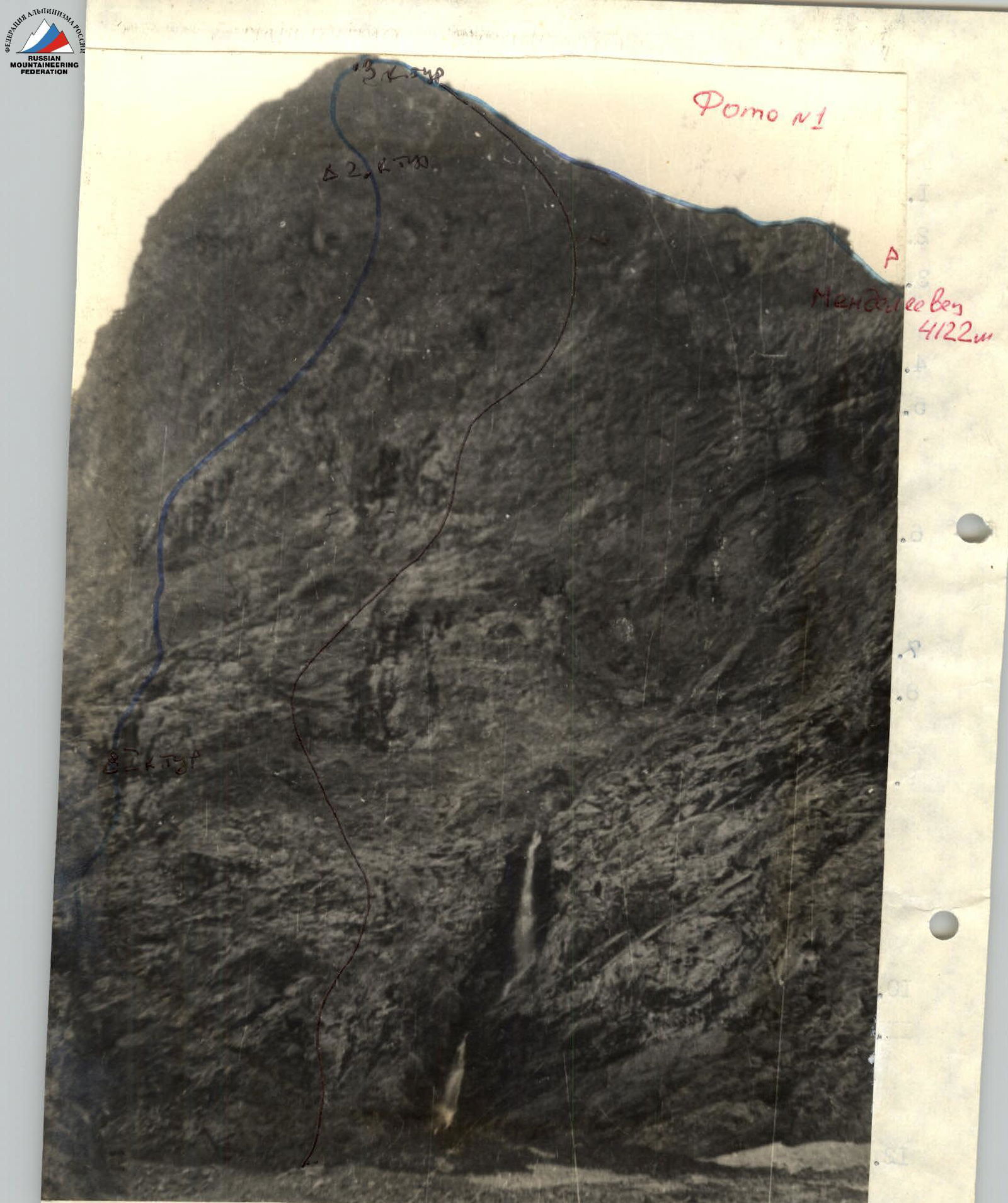
Route 5B category via the center of the North face triangle, route 5A category via the right edge of the North face.
Photo taken on July 9, 1988, 16:00. Lens — T-43 4/40 LOMO. Distance to the wall — 1500 m. Location on the map — "v". Camera height — 3000 m.
TACTICAL ACTIONS OF THE TEAM
For participation in the Chelyabinsk region alpine championship, the KFK "Almaz" team submitted a route on Mt. Mendeleevets via the center of the North face triangle, first ascent, approximately 5B category. The route is a wall climb, requiring serious rock climbing skills from the participants. With this in mind, a tactical plan was developed.
When developing the tactical plan, the following were considered:
- Steepness and diversity of rock terrain.
- Lack of convenient locations for bivouacs on the wall section of the route.
- Possibility of unfavorable weather conditions during the climb.
The key section of the route was the upper part of the North face triangle: R21–R22, R24–R28, R30–R34. When passing the upper wall, climbers frequently used ITO, although team members worked in caloshes. On the wall, pitons were often used for both ITO and belaying. The team started the route in full composition, with pairs organized according to the physical, technical, and moral-volitional qualities of the participants: 1st pair Zhmayev — Arkhipov, 2nd pair — Gadeev — Selivanova. From the start of the route to the upper third of the wall, the first pair (Zhmayev — Arkhipov) led. Further, until reaching the counterfort, the second pair (Gadeev — Selivanova) led. This tactic allowed the team to move evenly and safely. The pairs remained unchanged until the end of the ascent. For snacks during the climb, participants had individual high-calorie food.
Normal weather conditions, good acclimatization, physical and technical preparation of the team members allowed them to complete the route at a good pace, without deviating from the tactical plan's time schedule.
The successful completion of the route was facilitated by:
- High individual skill of team members — all participants have a confirmed CMS rank in rock climbing.
- Tactical competence.
- Lightweight backpacks, good equipment.
- Cohesion, clear understanding, and interaction between pairs.
Safety measures: To ensure safety, the first climber used a double rope (11 mm, Riga production), and an additional shock absorber; the first climber worked without a backpack; the team had a well-stocked first-aid kit, allowing for effective pre-medical assistance; "middle" climbers worked on a fixed rope with belay; the last climber was on a double rope.
Communication was maintained regularly using a "Lastochka" radio set. Additionally, the wall section of the route was clearly visible from the base camp in the AYU-TOR gorge, where a rescue team was stationed.
Team leader (coach) V.V. Zhmayev.
The approach to the route is via a talus cone, starting directly from the campsite under the triangle of Mt. Mendeleevets, its North face.
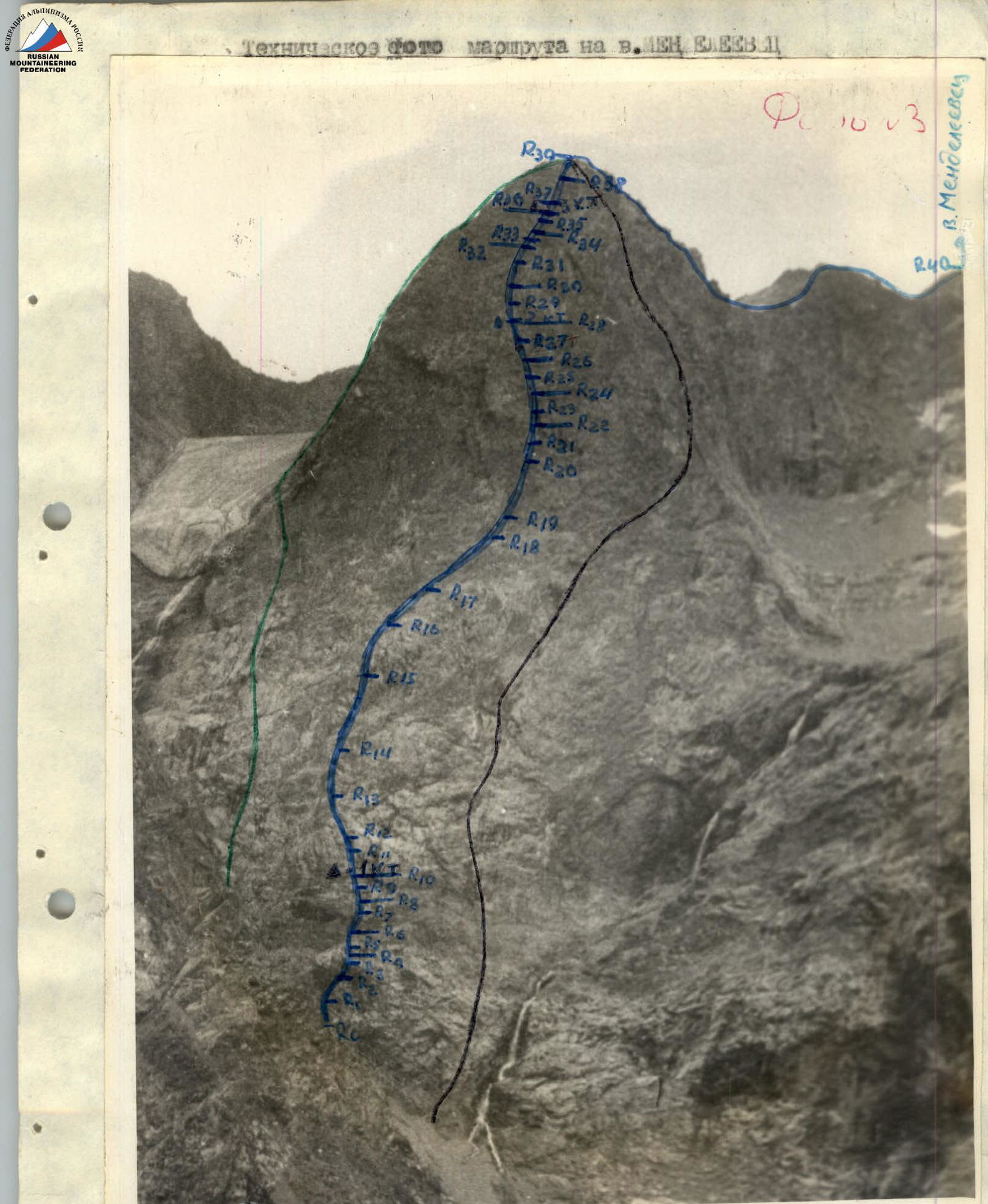
ROUTE DESCRIPTION BY SECTIONS
Section R0–R1 consists of several consecutive small walls (4th category), leading to a black ledge (R2), to the right of which is an internal corner. The belay station is not very convenient (R3).
Next, climb left and upwards, gradually transitioning from the wall (R4) to an internal corner (R5). Then, along a wide, scree-covered ledge (R6), move to a separate, wall-standing corner, 4–5 m high, with a crack on the left (R7). Here, organize a belay station.
After that, move left (R8–R10) under overhangs to a black patch — here is the first control point.
Further:
- climb vertically up a narrow chimney and internal corner (R11) to a small ledge;
- then, consecutively, several small walls (R12–R13), leading under a large slab, clearly visible from the campsite;
- in the left part, a wide chimney (R14) leads to an inclined wall, which brings you to a large rock tooth, standing in the lower part of the left upper black patch (R15);
- then, along a ledge left to a huge chimney with overhangs and drips (R16–R17).
Behind the chimney:
- inclined walls and ledges, 4–5 m;
- then, a wide internal corner begins, going right and upwards under a huge internal corner, clearly visible in the center of the upper part of the wall from the campsites (R18–R20);
- and then, along the right part of this internal corner, gradually moving right (R21–R24).
Further:
- through a small, 3–4 m ledge, across small walls (R25–R27);
- to an inclined internal corner (R28), leading to the 2nd control point.
After:
- along the wall (R30) to a ledge (R31);
- across the ledge and along the wall (R32) left — a convenient place for a belay station;
- further, slightly right, along an internal corner, along the wall to a small, 2 m ledge (R34), and then to a ledge (R35).
Then:
- along alternating walls and ledges (R36–R37) into an internal corner, going left and upwards, leading to the 3rd control point;
- after that, vertically up walls directly to the center of the wall triangle (R38–R39);
- further, along the ridge (R40) to the summit of Mendeleevets.
Route scheme and designations
| Section # | Length (m) | Steepness (deg.) | Difficulty category |
|---|---|---|---|
| R40 | 1200 | 45 | 4 |
| R39 | 45 | 45 | 3 |
| R38 | 20 | 60 | 3 |
| R35–R37 | 30 | 35–60–30 | 3–3 |
| R33–R34 | 31 | 60–85 | 3–3 |
| R32 | 28 | 60 | 3 |
| R30–R31 | 30 | 75–90 | 5–2 |
| R28–R29 | 17 | 85 | 5 |
| R27 | 30 | 60 | 4 |
| R25–R26 | 24 | 95–65 | 5–2 |
| R22–R24 | 28 | 80–70–80 | 5–4–5 |
| R21 | 19 | 80 | 5 |
| R19–R20 | 25 | 65–70 | 4–5 |
| R18 | 22 | 40 | 3 |
| R17 | 22 | 70 | 3 |
| R16 | 28 | 60 | 5 |
| R15 | 25 | 25 | 3 |
| R14 | 15 | 70 | 4 |
| R13 | 30 | 60 | 4 |
| R12 | 10 | 75 | 3 |
| R11 | 18 | 70 | 5 |
| R8–R10 | 12 | 80–60–80 | 5–4–5 |
| R7 | 14 | 60 | 4 |
| R6 | 18 | 40 | 3 |
| R5 | 8 | 50 | 3 |
| R4 | 10 | 30 | 2 |
| R2–R3 | 20 | 85–50 | 3–2 |
| R1 | 20 | 60 | 2 |
Technical photo of the route on Mt. Mendeleevets:
- 5B via the center of the North face triangle
- 5A via the left edge of the North face triangle
- 5A via the left edge of the North face triangle
Photo taken on August 11, 1988, 18:00, lens T-43 4/40 LOMO. Distance to the object — 2000 m, location on the map — "g", height — 3500 m.
- 5B via the center of the North face triangle
- 5A via the right edge of the North face triangle
- R0–R1–R2