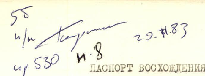
- Climbing category — rock climbing.
- Climbing area — Tian Shan, ridge — Teskey Ala-Too
- Peak, its height, climbing route: p. Mendeleevets, 4122 m, along the left edge of the northern wall triangle.
- Estimated category of difficulty — 5B.
- Route characteristics: height difference 1000 m (wall part 680 m), length of sections with 5–6 category of difficulty — 375 m, average steepness of the wall — 70°.
- Number of pitons and placements used: for belay 164, for TSD — 38.
- Number of travel hours — 25 (including 21 on the wall).
- Number of nights and their characteristics: July 10 — sitting bivouac, July 11 — lying bivouac.
- Team composition:
- KOMISSAROV Vladimir Anatolyevich — captain, Candidate for Master of Sports,
- ALSHULER Leonid Borisovich — participant, Candidate for Master of Sports,
- BYCHEK Alexander Mikhailovich — participant, Master of Sports,
- POMAZUEV Vladimir Vasilievich — participant, Candidate for Master of Sports.
- Team coach — BOSHMAN Werner Frantsevich — Master of Sports.
- Date of departure on the route — July 10, 1983, return — July 12, 1983.
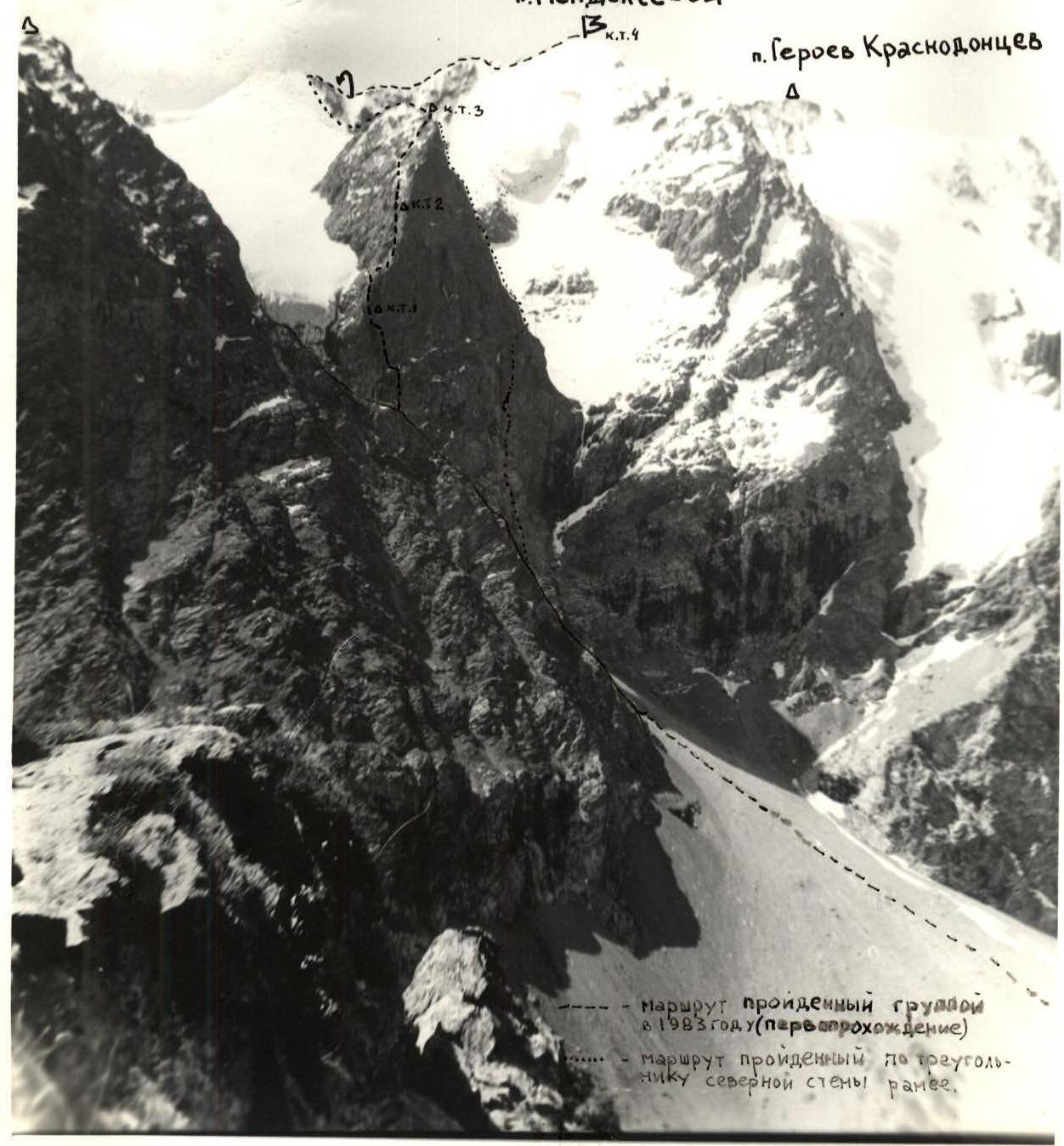 Route climbed by the group in 1983 (first ascent).
Route climbed along the triangle of the northern wall earlier.
Route climbed by the group in 1983 (first ascent).
Route climbed along the triangle of the northern wall earlier.
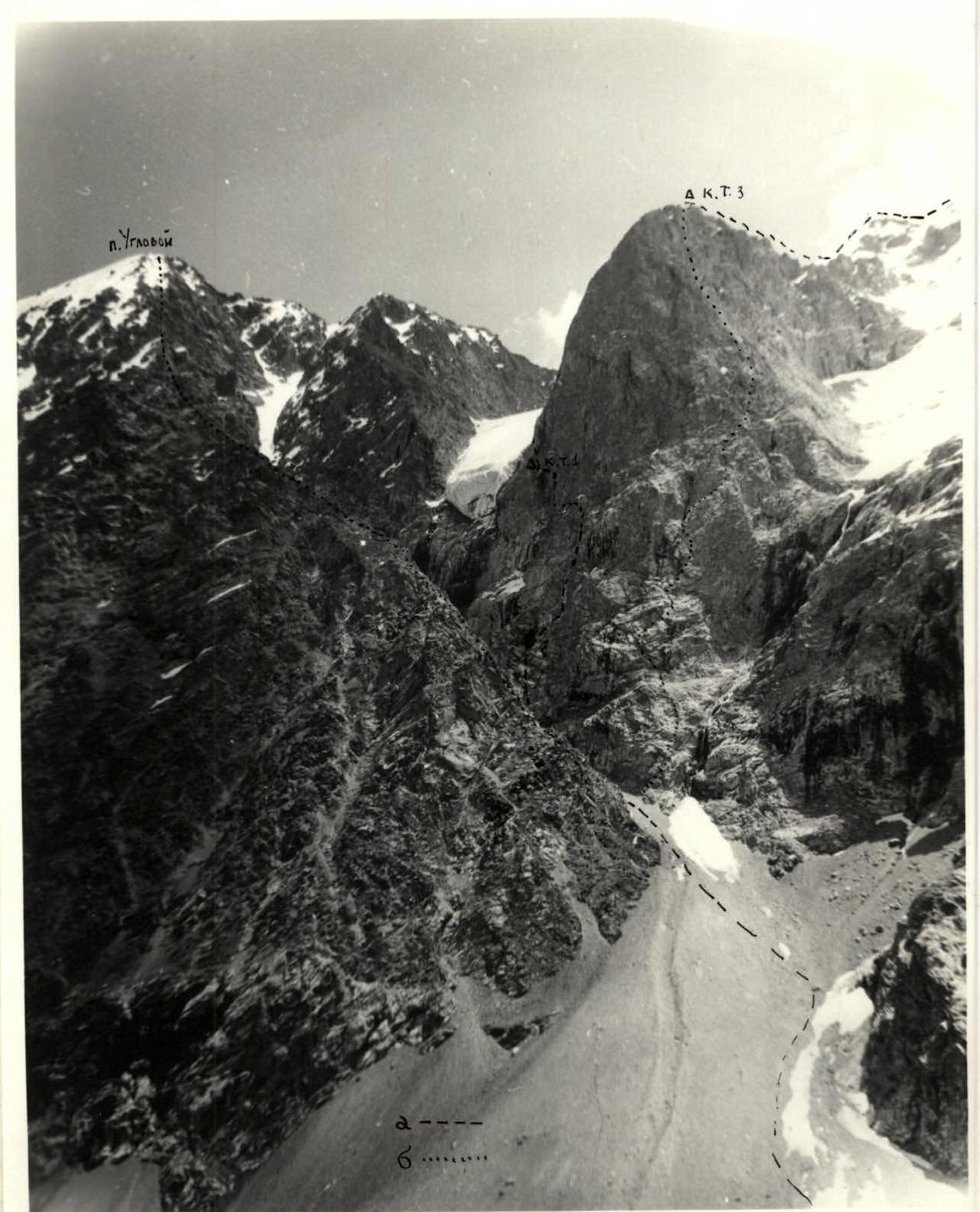 Photo 2. General view of the wall part of the route. a — route climbed by the group, b — routes climbed earlier.
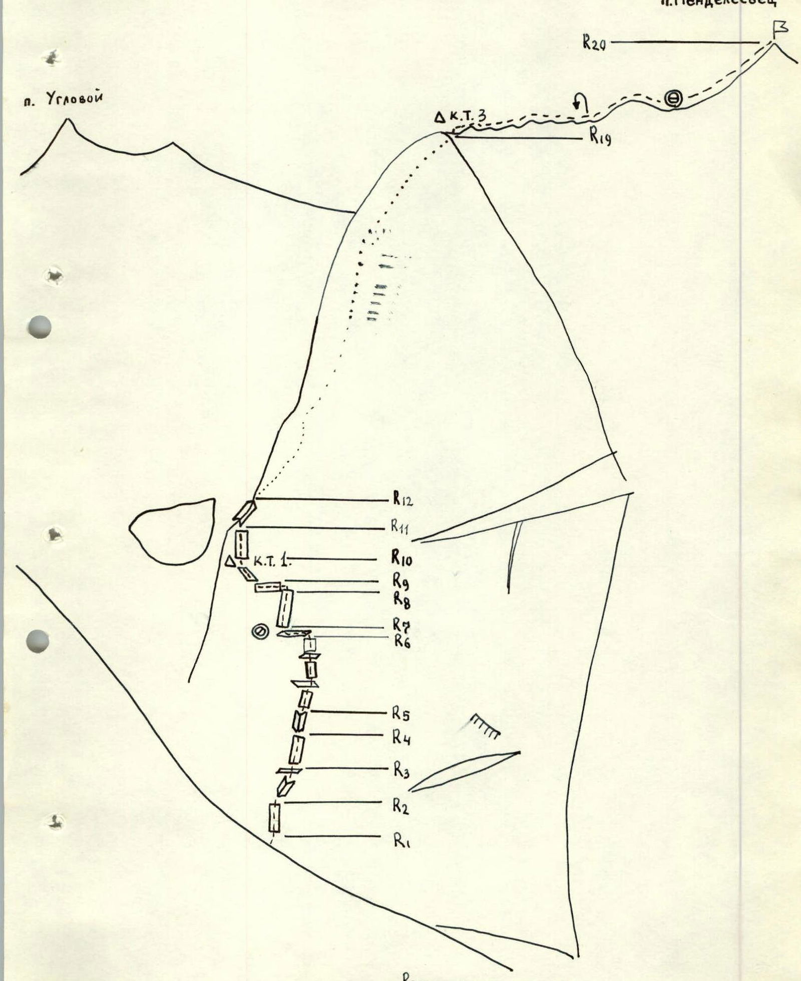 Fig. 3. Route diagram in symbols (lower part).
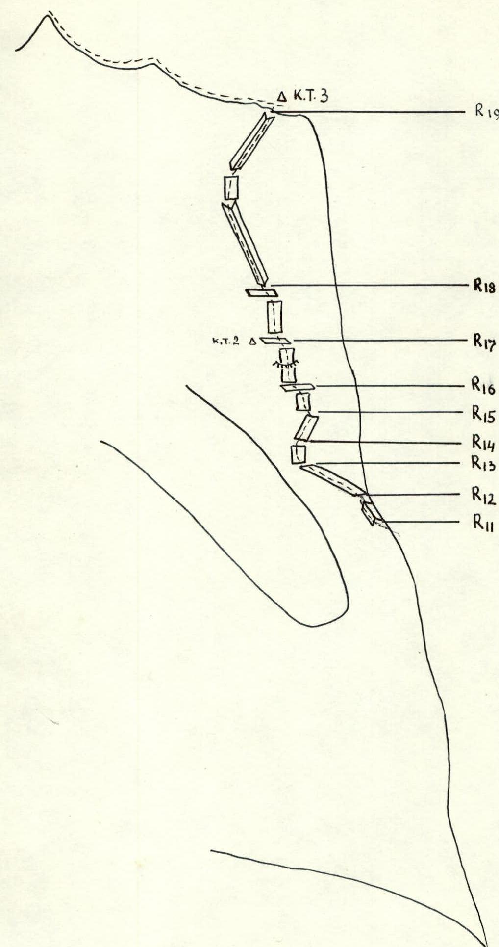 Fig. 4. Route diagram in symbols (upper part), view from the northeast.
Table of main route characteristics
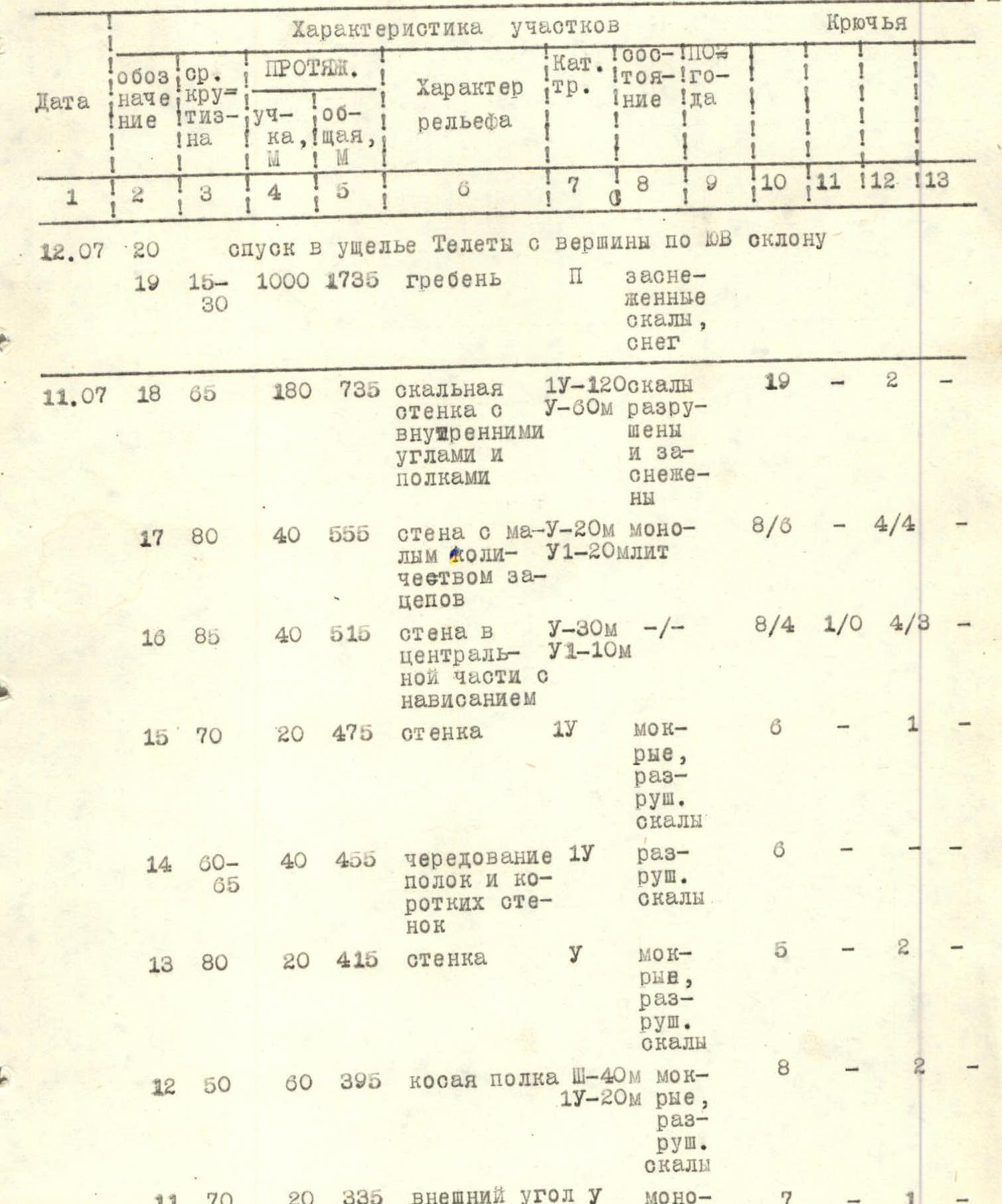
| Date | Section | Average steepness, ° | Length of section, m | Total length, m | Terrain characteristics | Category of difficulty | TSD | Pitons (belay) | Pitons (TSD) | Total pitons | Additional piton 1 | Additional piton 2 |
|---|---|---|---|---|---|---|---|---|---|---|---|---|
| July 12 | 20 | 15–30 | 1000 | 1735 | ridge | P | snowy rocks, snow | 19 | - | 2 | ||
| July 11 | 18 | 65 | 180 | 735 | rock wall with internal angles and ledges | 1У-120 У-60м | rocks are destroyed and snowy | 19 | - | 2 | ||
| 17 | 80 | 40 | 555 | wall with a small number of holds | У-20м У1-20м | monolith | 8/6 | - | 4/4 | |||
| 16 | 85 | 40 | 515 | wall in the central part with overhang | У-30м У1-10м | -/- | 8/4 | 1/0 | 4/3 | |||
| 15 | 70 | 20 | 475 | wall | 1У | wet, destroyed rocks | 6 | - | 1 | |||
| 14 | 60–65 | 40 | 455 | alternation of ledges and short walls | 1У | destroyed rocks | 6 | - | - | |||
| 13 | 80 | 20 | 415 | wall | У | wet, destroyed rocks | 5 | - | 2 | |||
| 12 | 50 | 60 | 395 | oblique ledge | Ш-40м 1У-20м | wet, destroyed rocks | 8 | - | 2 | |||
| 11 | 70 | 20 | 335 | external angle (edge) | У | monolith | 7 | - | 1 | |||
| 10 | 85 | 20 | 315 | vertical smooth slab with a wide crack | У1 | monolith | 10 | 2 | 6 | 2 | ||
| July 10 | 9 | 65 | 20 | 295 | oblique ledge | Ш | destroyed wet rocks | 3 | - | - | ||
| 8 | 90 | 15 | 275 | wall with overhang | У1 | -/- | 5 | 1 | 1 | 4 | ||
| 7 | 85 | 40 | 260 | wall with a gap in the upper part | У1-20м У-20м | -/- | 8/6 | - | 4/2 | 2 | ||
| July 10 | 6 | 55 | 40 | 220 | indistinctly expressed ledge | 1У | rocks are snowy and destroyed | 6 | - | - | ||
| 5 | 70 | 60 | 180 | alternation of ledges and walls | У | rocks are destroyed | 11/1 | - | 2 | |||
| 4 | 75 | 20 | 120 | internal angle | У | -/- | 5 | - | 1 | |||
| 3 | 65 | 40 | 100 | wall | У-20м 1У-20м | -/- | 12 | - | 1 | |||
| 2 | 65 | 20 | 60 | internal angle | У | -/- | 6 | - | - | |||
| 1 | 65 | 40 | 40 | wall | 1У | -/- | 6 | - | - | |||
| 0 | 20 | - | - | scree couloir | 1 |
Note: pitons, the number of which is indicated in the denominator, were used to create TSD, the rest were used for belay.
Brief explanation of the table
R0. Approach from the Aiu-Tor campsite along the scree under the wall, 200 m to the left of the central waterfall.
R1–R5. Movement starts upwards, always deviating slightly to the right, so that participants do not end up under each other. The section is a wall with an alternation of walls, oblique ledges, and internal angles. Along them, exit to a large indistinctly expressed sloping snowy ledge.
R6. Along the ledge, first up-left under the wall and then slightly left-down (5–8 m) to the wall with a gap (possible place for a sitting bivouac).
R7. Up the wall to the gap and along it further using TSD on the "plug" in the upper part of the gap under the cornice.
R8. Traverse left under the wall with overhang, using a runner on an oblique ledge. Pulling up backpacks. Water drips from above the overhanging part of the wall (in bad weather, a small waterfall flows here).
R9. Along the ledge left-up to the monolithic wall with a crack leading to the edge.
R10. Vertical slab with a wide crack (placements of large sizes are used for passage) leads to the edge. At the base of the crack, there is a control cairn.
R11. Up the edge, then left — exit to the northeastern face of the wall.
R12. Along the oblique ledge left-up above the glacier tongue to the wet wall.
R13–R14. Up the wall to the right-up towards the edge.
R15. Up the wall parallel to the edge along wet smooth rocks.
R16–R17. This is the most difficult section of the northeastern part of the wall. Climbing is complicated by wet rocks. In the upper part of the wall — an overhanging section (about 2 m long). Exit to the dissected wall with less steepness. In the central part of the wall, before the overhang — a control cairn on a piton.
R18. Along the wall with snowy rocks with an alternation of:
- internal angles,
- ledges,
- short walls — to the ridge.
R19. Along the ridge — simultaneous movement to the south towards the watershed of the Telty and Aiu-Tor rivers. There are places for lying bivouacs on the ridge. Along the watershed part of the ridge — to the west to the peak p. Mendeleevets.
R20. Descent along the southeastern slope into the Telty valley.