Ascent Passport
- Ascent class — rock
- Ascent area — Tian-Shan, Terskey-Alatau ridge, Ayu-Tor gorge
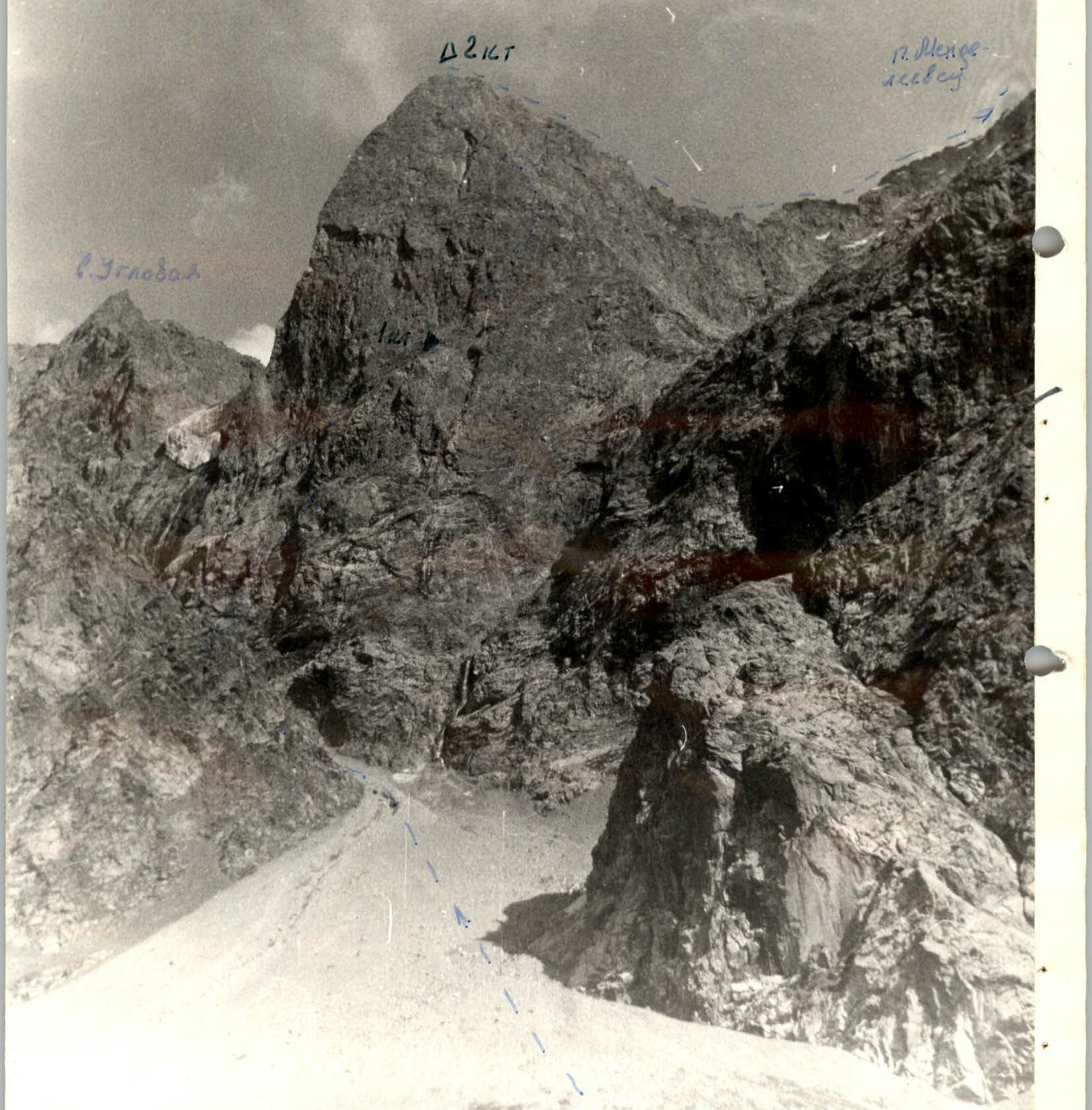
- Peak: Mendeleyevec Peak 4200 m
- Difficulty category: 5B
- Route characteristics a) Elevation gain — 900 m b) Length of R5–R6 sections — 578 m c) Average steepness — 67°
- Pitons driven: 79 a) For belay — 79 b) Ice — none c) For creating I.T.O. — 7 d) Bolts — 0
- Number of climbing hours — 12 hours
- Number of bivouacs — 1
- Team composition Kalyugin K.V. — CMS 443011 Kuibyshev, ring 104-74. Borodin S.A. — CMS
- Team coach — Kalyugin K.V.
- Date of departure on the route: August 12, 1981
Date of return: August 13, 1981
Route Profile (Diagram)
- Peak: Mendeleyevec Peak 4200 m
- Height 3300 m: Start of the route (R1), steepness 67°
- Route entry: August 12, 1981, 18:00
- Peak: August 13, 1981, 17:30
- Weather: Good, cloudy, snowfall, clear
Route sections:
- R1 (45°, 20 m): III-CL.
- R2 (70°, 20 m):
- R3 (65°, 20 m):
- R4 (60°, 40 m):
- R5 (80°, 10 m): VI I.T.O. Ladders.
- R6 (60°, 40 m):
- R7 (75°, 40 m):
- R8 (70°, 40 m):
- R9 (80°, 30 m): VI I.T.O. stirrups.
- R10 (50°, 40 m):
- R11 (75°, 40 m):
- R12 (75°, 40 m): Exit August 13, 1981, 11:30.
- R13 (90°, 20 m): V I.T.O. Ladders.
- R14 (75°, 100 m):
- R15 (75°, 90 m):
- R16 (80 m, 85°): VI I.T.O. Ladders. Exit August 13, 1981, 15:30.
- R17:
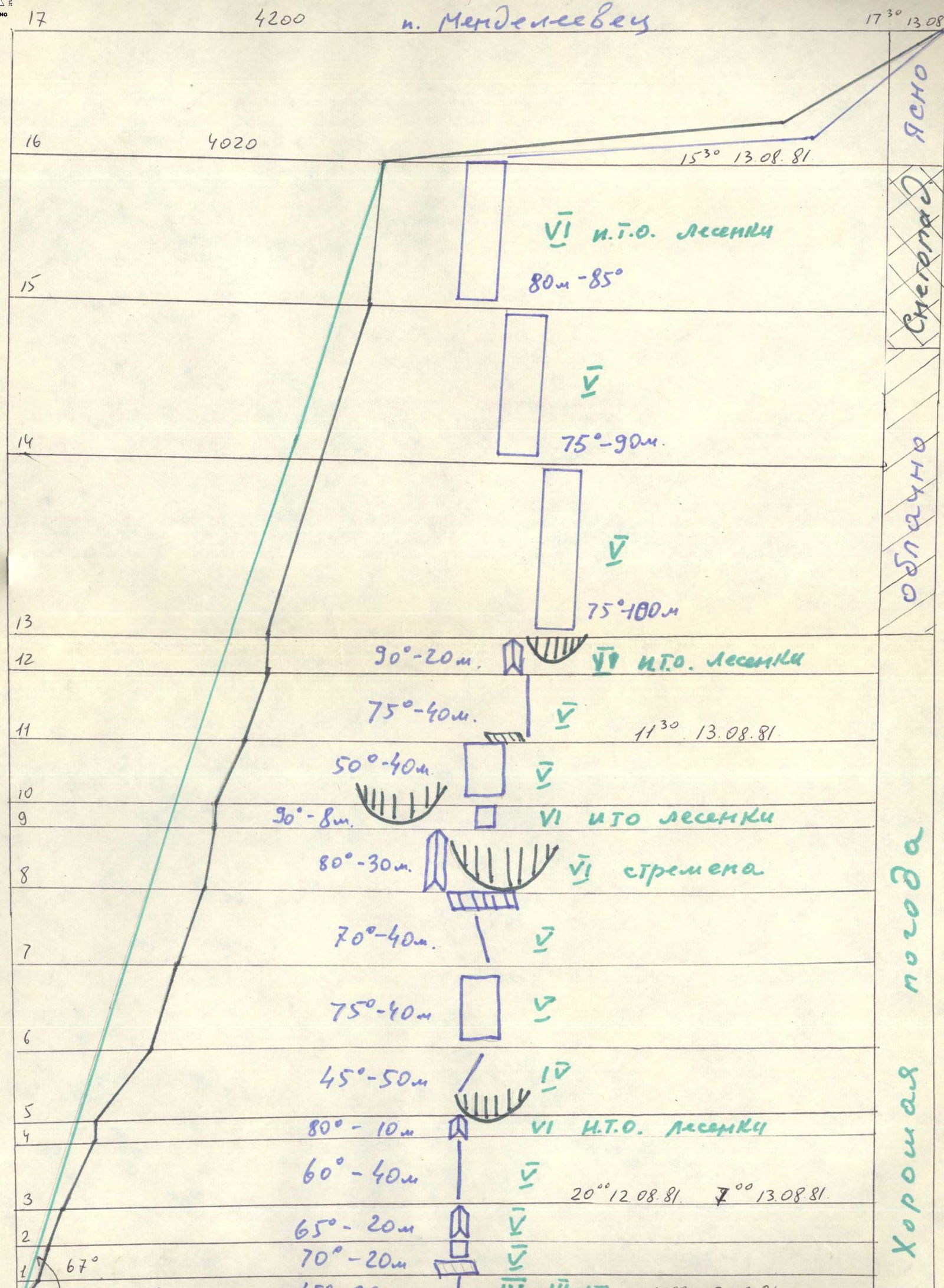
Table of main characteristics of the ascent route to Mendeleyevec Peak via the north wall, north edge R5–R6
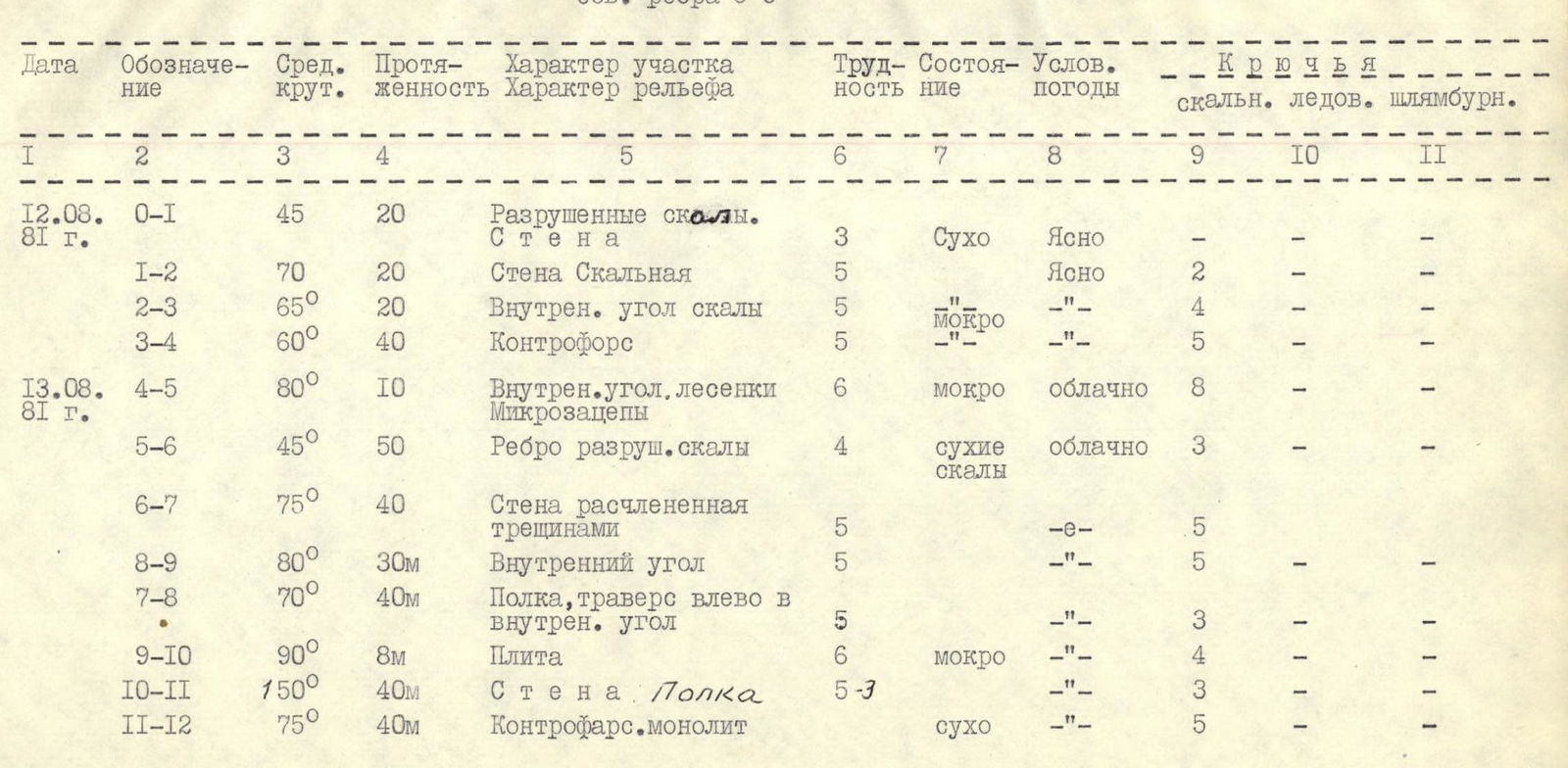
| Designation | Avg. steepness | Length | Section character | Section diff. cat. | Condition | Weather | Pitons (rock) | Pitons (ice) | Pitons (bolts) |
|---|---|---|---|---|---|---|---|---|---|
| August 12, 1981 | |||||||||
| R0–R1 | 45° | 20 m | Crushed debris. Wall | 3 | Dry | Clear | – | – | |
| R1–R2 | 70° | 20 m | Rock wall | 5 | Clear | 2 | – | – | |
| R2–R3 | 65° | 20 m | Internal rock corner | 5 | Wet | – | 4 | – | – |
| R3–R4 | 60° | 40 m | Counterfort | 5 | – | 5 | – | – | |
| August 13, 1981 | |||||||||
| R4–R5 | 80° | 10 m | Internal corner, ladders. Micro- ledges | 6 | Wet | Cloudy | 8 | – | – |
| R5–R6 | 45° | 50 m | Edge of destroyed rocks | 4 | Dry rocks | Cloudy | 3 | – | – |
| R6–R7 | 75° | 40 m | Wall dissected by cracks | 5 | – | 5 | – | – | |
| R8–R9 | 80° | 30 m | Internal corner | 5 | – | 5 | – | – | |
| R7–R8 | 70° | 40 m | Ledge, traverse left to internal corner | 5 | – | 3 | – | – | |
| R9–R10 | 90° | 8 m | Slab | 6 | Wet | – | 4 | – | – |
| R10–R11 | 50° | 40 m | Wall. Ledge | 5–3 | – | 3 | – | – | |
| R11–R12 | 75° | 40 m | Monolithic counterfort | Dry | – | 5 | – | – | |
| R12–R13 | 90° | 20 m | Oblique internal overhanging corner. Smooth slab I.T.O. | 6 | Dry | Cloudy | 6 | – | – |
| R13–R14 | 75° | 100 m | Monolithic wall | 5 | Snow-covered rocks | Snowfall | 8 | – | – |
| R15–R16 | 75° | 90 m | Monolithic wall | 5 | – | – | 8 | – | – |
| R16–R17 | 85° | 80 m | Monolithic wall, fresh breaks, ridge 3 diff. cat. | 6 | – | – | 10 | – | – |
| R17–R18 | – | – |
Description of the first ascent route to Mendeleyevec Peak, 5B difficulty category
From the bivouac under the "ram's foreheads" to the base of the wall — 35 minutes. Left along the scree couloir 150 m to a not very pronounced counterfort located behind the narrowing of the couloir. Simple rocks (20 m) — exit to a ledge under the counterfort. The beginning is marked by a cairn.
Further:
- straight up the wall (20 m, 70°);
- along the internal corner (20 m, 65°);
- along the counterfort 40 m to an overhanging wall 20 m, which is passed along a smoothed wet internal corner 10 m, 80°;
- to the right — up along the ledges — climbing of medium difficulty, 50 m;
- straight up the wall (40 m, 75°);
- along a ledge to the left of the overhanging tower with black streaks — straight up (30 m, 80°, difficult climbing, ladders);
- along the wet corner to the left (8 m) and up (40 m) along the wall to a ledge;
- to the right-up 100 m — rocks of medium difficulty.
Exit to a scree ledge under the overhanging reddish summit bastion. Bivouac. First control cairn.
From the ledge to the right to a pronounced counterfort of the bastion, straight up along it (40 m, 75°) to an overhanging wall, which is passed along an oblique overhanging internal corner to the left (very difficult climbing with artificial support (ladders) 20 m, 90°–100°). Further up the wall to the exit to the edge of the wall (100 m, 75°). Along the edge of the wall to the summit tower "triangle" 90 m, 75°. Bivouacs are possible.
Exit to the summit tower along the "reddish" wall 80 m (80°–90°). On the ridge, bivouacs are possible.
Along the ridge 2 hours exit to the summit of Mendeleyevec Peak. Descent via 2A difficulty category to the Ayu-Tor or Telety gorge from the saddle between Mendeleyevec Peak and Geroi Krasnodontsev along the scree couloir.
Kalyugin K.V. Borodin S.A.
Conclusions and Recommendations
- The route is rock, logical, objectively safe, saturated with difficult and diverse climbing. Corresponds to 5B difficulty category.
- Technically, the route is much stronger than the previously passed routes to Pamyati Blyukhera Peak 5B, Suloeva Peak 5B, Ullu-Tau peak via the center of the north wall 5B, and is slightly inferior to the route to Arg Peak via the north wall 5B difficulty category.
- For passing the route, a diverse assortment of pitons, ladders is required. In the middle and upper parts of the wall, placement of protection elements is widely used. The relief allows for reliable belay throughout the route.
- On difficult sections, the first climber should go without a backpack and in caloshes.
- In bad weather — a frequent occurrence in this area — the passage of the route becomes significantly more complicated.
- There is no water on the wall!
- It is necessary to plan a bivouac on the route.
- Descent along the scree couloir to the Telety gorge from the saddle between Mendeleyevec and Uzlovaya is possible. In this case, there is no need for ice equipment.
- The route is very convenient due to the close approaches from the "Ala-Too" tourist base. It is a good rock addition to the combined routes of this area.
- The route is not recommended as the first 5B difficulty category route. Team composition — no more than 4 people.
Handwritten Records
Route to Mendeleyevec Peak via the north wall and north ridge. Second ascent by a group of Nekroev Polyakov August 17–18, 1981.
We passed the route of the first ascenders on the wall and bypassed their control cairn. This is false. 2nd diff. cat. at the cairn. Note. Kayunin August 13, 1981.
The board of climbers of the "Ala-Too" tourist base reports on the ascent to Mendeleyevec Peak 5B difficulty category (first ascent) composed of Kalyugin K.V., Borodin S.A., Kuibyshev. The weather is good. We greet the climbers, 11:00.
Kayunin
August 18, 1981
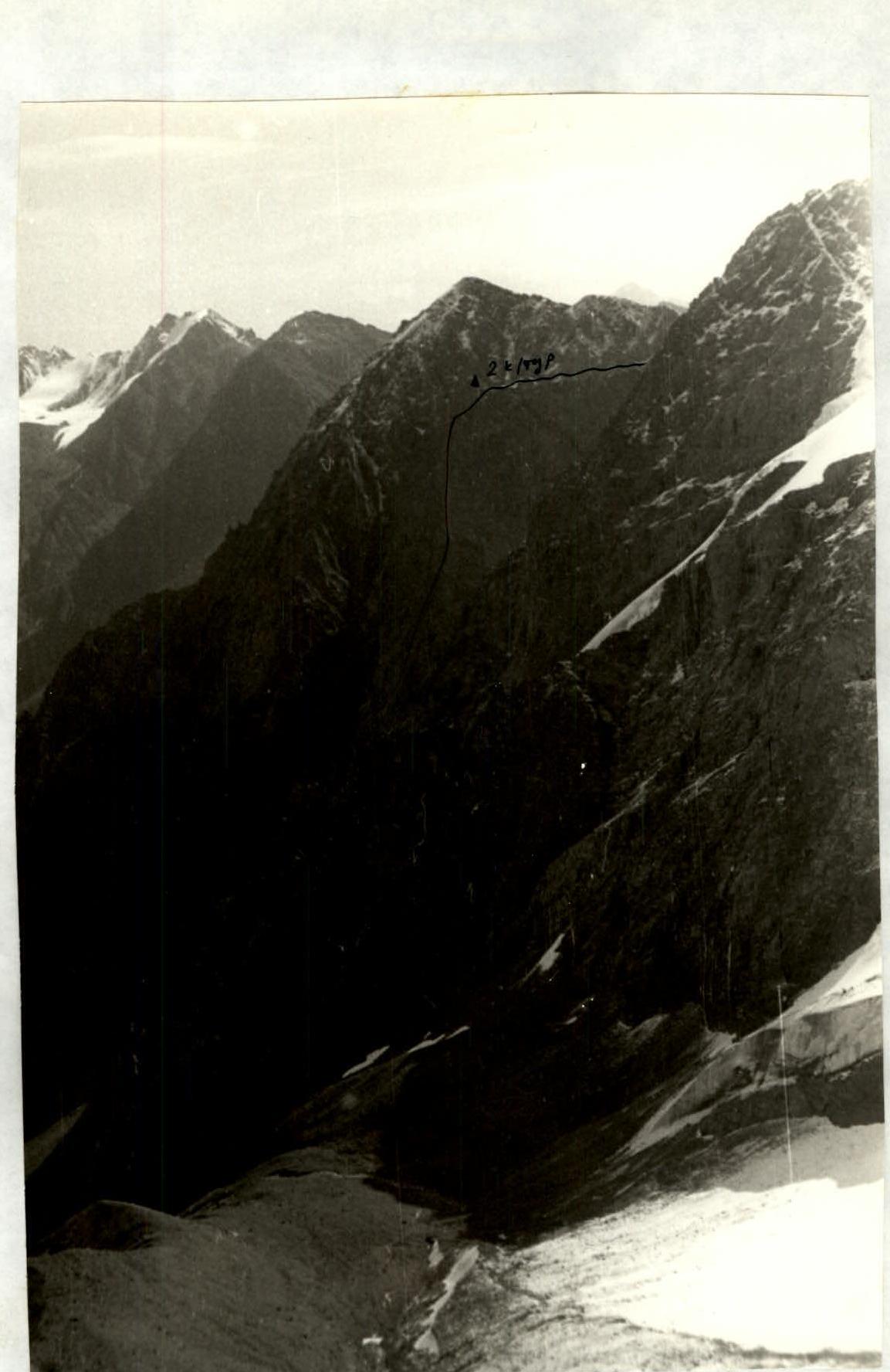
Profile of the "Triangle" Wall
Profile of the "Triangle" wall. Projects from all sides onto the surrounding mountains. The photo was taken from the ridge of Ayuter Peak.