MOUNTAINEERING FEDERATION OF THE LITHUANIAN SSR
May 21, 1970
TRAVERSING THE PEAKS OF JACQUES DUCLÔS — 4270 m — 4270 m — PIK G. AKSTINASA (KARAKOL VALLEY, TIAN SHAN)
Leader: B. BINKAUSKAS, first ascent
Route Description
Traversing Jacques Duclôs – 4270 m – 4270 m – Pik G. Akstinasa
Category 3A route
The route starts from a campsite on the left moraine of the On-tor Glacier (see Scheme I). The campsite is well-protected from the wind, and there is water available, but it's necessary to dig trenches around the tents to avoid trouble from water flows resulting from rain.
The ascent to Jacques Duclôs Peak begins with a climb straight up from the campsite. The route then proceeds through the following sections:
- Crossing the glacier via a moraine that turns into a ridge.
- The ridge is bypassed on the right via a covered glacier, using ropes.
- In the upper part, crossing the ridge via a steep snowfield and easy rocks, we reach a snowy plateau below Jacques Duclôs Peak.
To ascend to the summit, it is necessary to:
- Cross a bergschrund (Photo 1).
- Follow a snowy ridge for a straightforward ascent to the summit, using an ice axe for belay.
By the end of summer, ice may be present on the route. The journey from the campsite to the summit takes 3–4 hours.
The descent from the summit:
- Initially follows the ascent route.
- Then, a transition to the right via a steep snowfield onto a wide snowy ridge with cornices, leading to the 4270 m peak.
- The ascent to the 4270 m peak is via simple rocks that end in cliffs, with belay through rock outcrops.
The journey from Jacques Duclôs Peak to 4270 m I takes 20–30 minutes with good snow conditions.
The descent from 4270 m I:
- Follows the ascent route.
- Continues along a simple ridge towards 4270 m II, leaving a less distinct peak on the left.
- The ascent to 4270 m II is via a steep snowy ridge (one rope), then via severely damaged rocks.
The journey between the two 4270 m peaks takes approximately 1 hour. Be cautious of snow cornices.
The descent from the 4270 m peak should be planned from the summit:
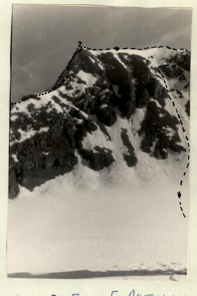
- In the absence of cornices on the ridge leading to Pik G. Akstinasa, it's possible to descend initially via the ascent route (1 rope), followed by traversing an icy slope with belay through rock outcrops (Photo 2) – 3 ropes – to reach a snowy ridge.
- If there are hazardous cornices on the ridge, consider rappelling directly from the summit to the snowy ridge (piton belay).
The ridge becomes more gradual and leads to a cairn below Pik G. Akstinasa.
The ascent to the summit follows the ridge – 2. The descent from the summit:
- Initially along the ridge – 3–4 ropes.
- Then to the right via a snowy-icy slope, approximately 1.
Participants of the first ascent:
- Binkauskas B.B., 1st sports category, leader.
- Stepanov V.V., Master of Sports.
- Montvillas K.T., Candidate for Master of Sports.
- Shaduikis V.V., Candidate for Master of Sports.
- Adomaitis E.P., Candidate for Master of Sports.
- Antanavichyus Yu.Yu., Candidate for Master of Sports.
The route was evaluated as Category 3A. The route description was written by the ascent leader, B. Binkauskas.
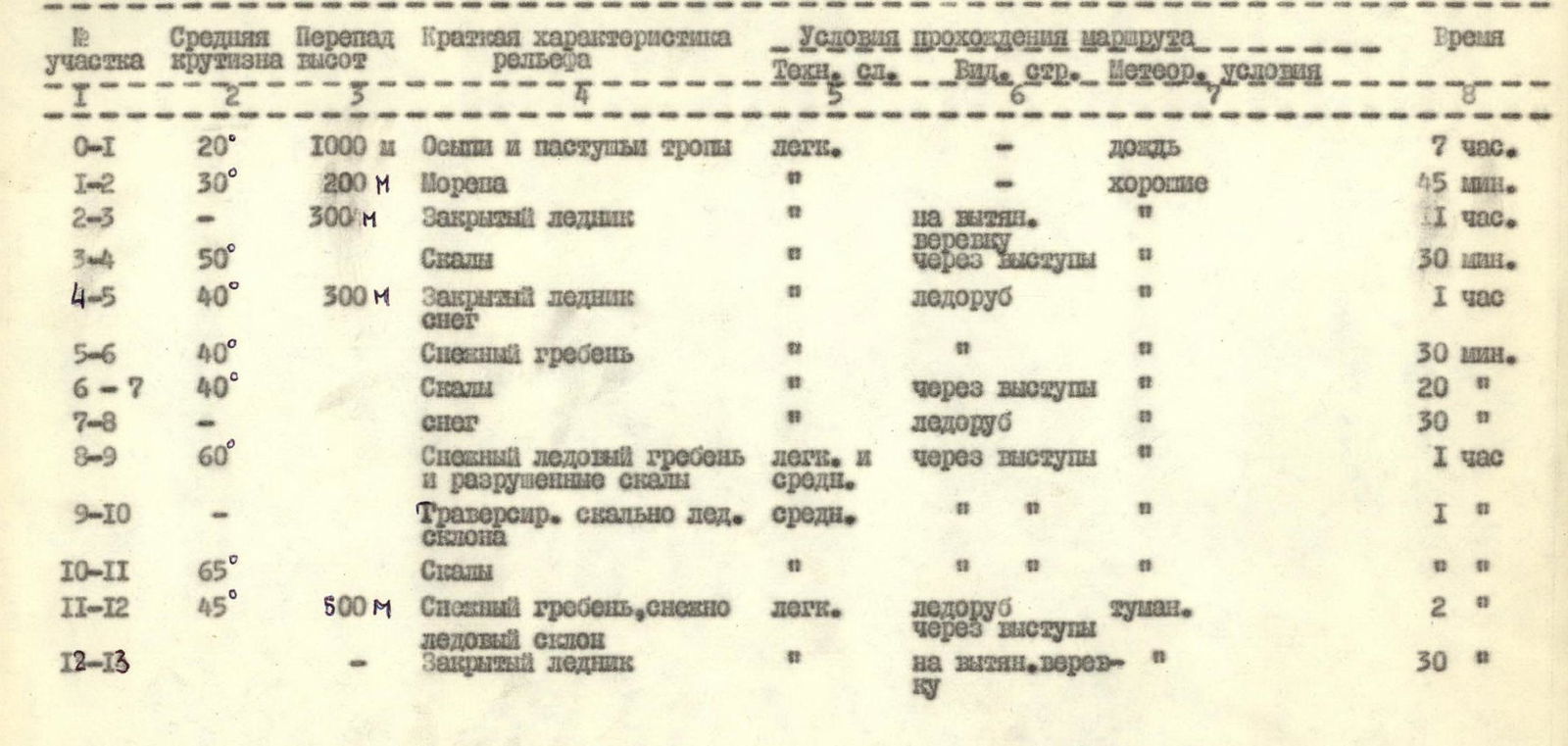
Route Characteristics Table
| Section | Average steepness | Height difference | Brief terrain characteristics | Technical difficulty | Belay type | Weather conditions | Time |
|---|---|---|---|---|---|---|---|
| R0–R1 | 20° | 1000 m | Scree and shepherd trails | easy | – | Rain | 7 hours |
| R1–R2 | 30° | 200 m | Moraine | – | good | – | 45 min. |
| R2–R3 | – | 300 m | Covered glacier | – | on a stretched rope | – | 1 hour |
| R3–R4 | 50° | – | Rocks | – | through rock outcrops | – | 30 min. |
| R4–R5 | 40° | 300 m | Covered glacier, snow | ice axe | – | – | 1 hour |
| R5–R6 | 40° | – | Snowy ridge | – | – | – | 30 min. |
| R6–R7 | 40° | – | Rocks | – | through rock outcrops | – | 20 min. |
| R7–R8 | – | – | Snow | – | ice axe | – | 30 min. |
| R8–R9 | 60° | – | Snowy-icy ridge and damaged rocks | easy and medium | through rock outcrops | – | 1 hour |
| R9–R10 | – | – | Traversing a rocky-icy slope | medium | – | – | 1 hour |
| R10–R11 | 65° | – | Rocks | – | – | – | 1 hour |
| R11–R12 | 45° | 500 m | Snowy ridge, snowy-icy slope | easy | ice axe, through outcrops | fog | 2 hours |
| R12–R13 | – | – | Covered glacier | – | on a stretched rope | – | 30 min. |
 |
Ascent scheme.
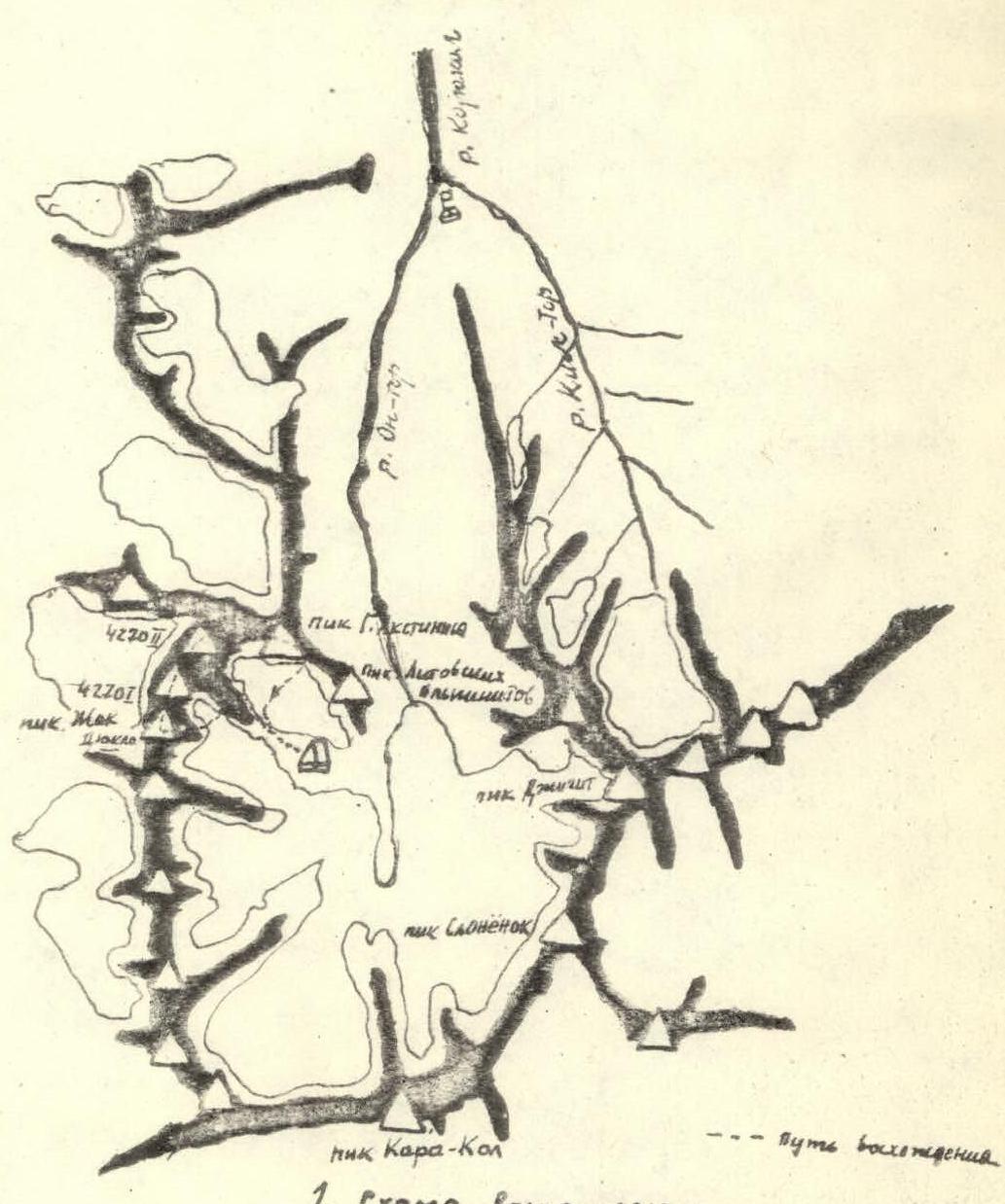
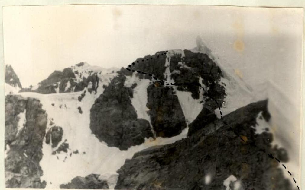
Photo 1. View of sections R8–R9, R9–R10 from Pik G. Akstinasa summit.
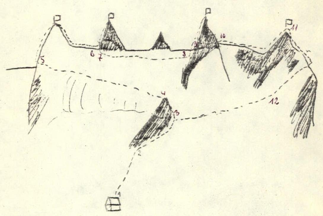
Photo 2. Pik G. Akstinasa.
Scheme 1. Ascent scheme.