№ 21. DESCRIPTION OF THE ASCENT TO THE "BRIGANTINA" PEAK
B. Bloshtein, 1966 3rd ascent via O. Trubnikova's route, 1965 5A category (according to this report) 2nd ascent - V. Osipov, 1965 (August 15-18, 1965) 1st ascent - O. Trubnikova, 1965 (August 4-6, 1965) –1966–
The "Brigantina" peak (4800) is located in the main part of the Terskey-Ala-Too ridge, 60 km south of Przhevalsk.
Approach via the Kokbor valley:
- The Kokbor River is a right tributary of the Karakol River.
- A truck can reach 19 km up the Karakol valley.
- Further on, a good horse trail continues for 21 km.
- The last 11-12 km to the tongue of the "Brigantina" glacier are along shepherds' trails.
The "Brigantina" peak is approximately 10-12 km east of "Dzhigit" (see orographic diagram).
The "Brigantina" peak, like all surrounding peaks, is composed of granites enriched with feldspar in many places.
The ascent to the "Brigantina" peak was made on August 4-6, 1965, via the northern ridge by a group consisting of:
- MS Trubnikova O.I. - leader
- CMS Levchenko N.I. - member
- 1st category Grelikh P.F. - member
- 1st category Grafov V.I. - member
At the same time, August 3-7, 1965, another group:
- CMS Samokhvalov V.V. - leader
- MS Ryabukhin A.G. - member
- 1st category Makovetsky V.A. - member
- CMS Osipov V.P. - member
ascended the peak via the northwestern ridge and traversed to the "Albatross" peak.
On August 15-18, 1965, the group:
- CMS Osipov V.P. - leader
- 1st category Reznikov B.A. - member
- 1st category Sychev Yu.N. - member
- 1st category Denisov V.M. - member
repeated the route of MS Trubnikova's group.
Our group:
- 1st category Bloshtein B.E. - leader
- MS Rozhalskaya G.K. - member
- 1st category Tamplon V.S. - member
- 1st category Gavrilchik V.I. - member
made the ascent via the northern ridge on July 21-23, 1966 (following MS Trubnikova's route). The route is combined: snow, ice, and rock. The average slope is 50°, with a height difference of 1280 m (3520-4800). The route is sunlit from 6:00 to 19:00. Meteorological conditions in the area are harsh. Precipitation often occurs in a pronounced periodic manner. Advice on the route was provided by Comrades Trubnikova and Osipov. The entire route is visible from the approaches in the Kokbor valley.
The group's equipment was standard:
- Main rope - 2 × 40 m
- Climbing harnesses - 4 pcs
- Carabiners - 16 pcs
- Rock pitons - 20 pcs
- Ice pitons - 3 pcs
- Ice axes - 3 pcs
- Ice hammer - 1 pc
- Crampons - 2 pairs
- Ladders 1.5 m - 2 pcs
- Rock hammers - 2 pcs
- Auxiliary rope - 10 m
Communication with groups under the "Dzhigit" peak was maintained using flares.
Rope teams during the ascent:
- Bloshtein B.E. - Gavrilchik V.I.
- Tamplon V.S. - Rozhalskaya G.K.
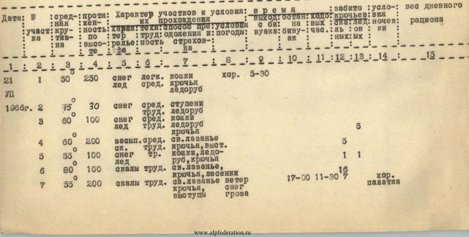
The group set up camp on July 20, 1966, at 17:00 under the route on the "Brigantina" glacier (photo 3).
Two members (Bloshtein, Tamplon) went to scout the northern slope. The scouting party chose an ascent route via an avalanche debris cone. The snow was dense, and ice was encountered in the upper part of the slope before the first bergschrund. The route was prepared up to the upper ledge of the icefall (R1). The icefall was traversed in the central part via bridges. The pair returned to camp at 19:30.
The group's departure for the route was on July 21, 1966, at 5:30.
Ascent to the upper ledge of the icefall R1. The ledge was broken by crevices, many of which were completely covered with snow, requiring careful probing of the slope. When crossing crevices over snow bridges, safety was ensured using two ice axes (R1, photo 5).
In the right part of the ledge, a snow slope with a steepness of 20-30° led to a sharp snow ridge (R2). This section was complex. In the lower part, the snow was deep and dense. Safety was ensured using an ice axe. In the middle part, the ice axe penetrated halfway. Snow was cleared for ice pitons. The last 30 m featured exposed ice. The team proceeded on crampons with step cutting and piton protection.
The ridge led to a couloir. The couloir was exposed to falling rocks. The team traversed via rocks on the left side of the couloir (R4). The rocks were heavily fragmented (photo 6), with many loose stones. Safety was ensured using pitons and rock features.
After the couloir, a steep snow ridge followed (R5). The snow was heavy, 10-20 cm deep, and loose. Steps did not hold. The team moved on crampons. In the upper part, steps were cut. Safety was ensured using an ice axe. In the middle part, ice pitons were used, and in the upper part, rock pitons.
Via moderately difficult rocks, the team approached a wall (R6). Climbing was very challenging. In three places, ladders were hung. The wall's slabs were somewhat fragmented, with many cracks for pitons and ledges for resting.
After the wall, a complex rock ridge followed (R7, photo 8), featuring numerous small 5-10-meter sheer walls. Safety was ensured using pitons and rock features.
The weather deteriorated, and the team had to stop for the night at 17:00. Clearing a site for the tent took 2 hours. Camping conditions were good (photo 9).
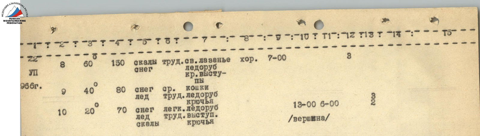
On July 22, 1966, at 7:00, the team continued on the route. Immediately after the rock ridge, they encountered gendarmes. The first was taken head-on, the second was bypassed on the left, and the rest on the right (R8). This section was complex, with a mix of snow and rock.
After the gendarmes, a snow ridge of moderate difficulty followed (R9, photos 11-13). The team ascended to a snow saddle between two gendarmes and then onto the eastern ridge. Upon reaching the eastern ridge, two snow-ice ascents were encountered. Safety was ensured carefully. The team moved on crampons, cutting steps.
The team reached the eastern ridge at 11:00. Leaving their backpacks, they proceeded along the eastern ridge to the summit (R10, photos 14-17).
The ridge was steep, with нависающими cornices on the southern slope. Upon approaching the summit, a steep snow-ice ascent was encountered. Steps were cut, and an ice piton was used.
The team reached the summit at 13:00.
The descent was made along the eastern ridge to the point of ascent onto it. Here, they cut through a cornice and descended onto the southern slope - via moderately difficult rocks, constantly traversing leftward, they descended to the glacier. The descent from the ridge to the glacier took 5 hours.
There were no suitable sites for setting up a tent along this path.
To subsequent groups, we recommend:
- not starting the descent from the ridge later than 15:00 and under deteriorating weather conditions.
The relatively easy ascent to the saddle between the two gendarmes took 1.5 hours. They reached the saddle at 22:30. The saddle featured a very convenient depression. The descent from the saddle was made via the left rocks, exiting onto the upper ledge of the icefall, and then following their own tracks to the "Brigantina" glacier. The entire descent from the saddle took 3 hours.
Total time on the route was 27 hours. When ascending via the northern ridge, special attention should be paid to loose stones. Often, even large stones barely cling to the ridge. There are few shelters from falling stones.
The group considers the route to be more challenging than 5A category routes in the "Talgar" area, such as:
- the traverse of "Talgar"
- "Karatau".
Ascent leader
Table of Main Characteristics
Route of ascent: northern ridge of the "Brigantina" peak Height difference on the route 1280 m (3520-4800), including complex sections:
- rock - 400 m;
- snow-ice - 300 m. Average slope of the route - 50°, including complex sections:
- rock - 65°;
- snow-ice - 50°.
A total of 43 pitons were used on the route, including:
- 32 rock pitons
- 11 ice pitons.
Ascent leader - 1st category (Bloshtein B.E.)
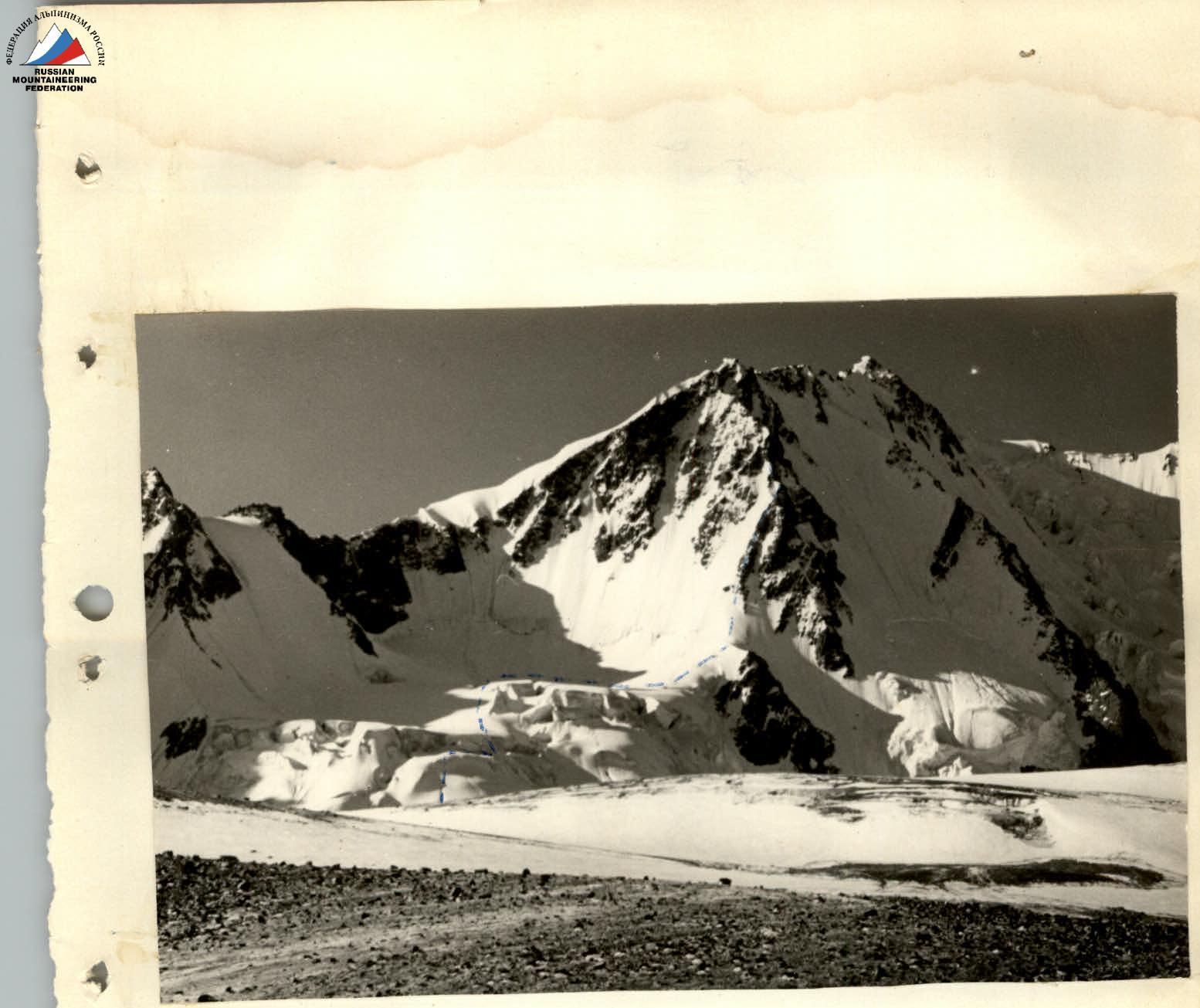
Photo 1. "Brigantina" peak. View from the Kokbor valley
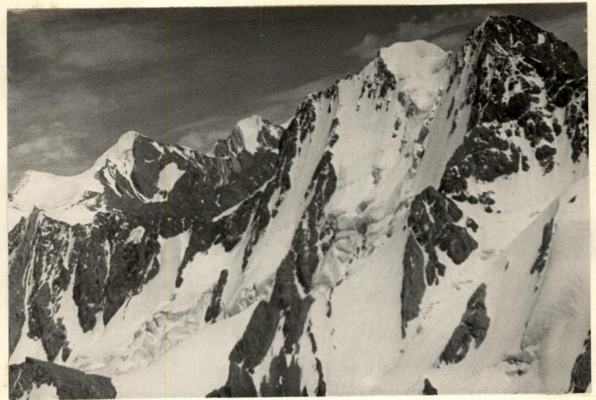
Photo 2. "Brigantina" and "Albatross" peaks from the "Delone" peak

Photo 3. Camp on the "Brigantina" glacier. The ridge of the "Albatross" peak and "Dzhigit" peak are visible


