
DESCRIPTION OF THE ASCENT TO PEAK AYUTER (4382 m) FROM PRIZYVNIC PASS.
MOSCOW — 1969.
Description
of the ascent to peak Ayuter from Prizyvnik pass.
Peak Ayuter is the main summit of the Ayuter gorge, located in the meridional spur of the Terskey Ala-Too ridge (see orographic scheme) and closes the Ayuter gorge.
Peak Ayuter, like all the surrounding peaks, is composed of granites, which are enriched with feldspars in many places.
Currently, there are three classified routes to peak Ayuter:
- 3B — along the north-eastern ridge;
- 4A — along the western edge;
- 4B — along the northern ridge from the Ayuter gorge.
The route along the southern ridge from Prizyvnik pass has not been climbed before and is not classified.
The route of the upcoming ascent was studied visually during ascents to nearby peaks, as well as during ascents to peak Ayuter via classified routes.
When climbing in this area, it is necessary to consider the features of meteorological conditions. Periods of prolonged bad weather are pronounced. In addition, daily (with very rare exceptions) precipitation from 13:00 to 17:00–18:00 makes certain demands on the organization of ascents in this area.
Communication and interaction
During the ascent, the group had constant visual contact with groups making ascents in this area. The route of the upcoming ascent is clearly visible from the peaks:
- GTO
- Gastello
- Geroyev Krasnodona.
All groups in this area were instructed to interact and observe.
Organization of the ascent
Day 1. Departure from the "Ilkychat" camp (interfluve) from the base camp of the gathering to the tongue of the GTO glacier. The journey takes 4 hours. The description of the approaches to the tongue of the glacier does not require a description, as the path goes all the time along the trail, only when exiting under the tongue of the glacier the trail is lost among the talus.
Day 2. Early exit along the closed glacier with traces of spring avalanches under Prizyvnik pass and exit to it. The journey takes 2 hours. The beginning of the route — exit from the pass to the ridge to peak Ayuter along the inner corner with a large number of "live" stones. Insurance is organized through individual feathers, which must be carefully checked before organizing insurance. The length of the section is 60 m.
Further, to the left of the ridge along the slabs with a steepness of 45–50° — exit to the ridge. The length of the section is 80 m. On the ridge there is a site where you can gather everyone together.
Further from the site to the right along the cleft — exit to the ridge under the base of the Red ascent, which should be passed head-on. It should be noted that bypassing the Red ascent both to the right and to the left is irrational, since on both sides there are smooth plumbs. The length of the ascent is 30 m, the rocks are of medium difficulty, and the insurance is hooked.
Further:
- Slab with a steepness of ~60°, small footholds, hooked insurance, slab length 40 m.
- Separate sections of the slab are passed by the one going forward "on friction".
- Passing this slab during or after bad weather, when the rocks are wet, presents a certain difficulty, the overcoming of which may require hammering in two or three piton hooks.
Further, the jagged ridge with a steepness of 35–40° with a length of ~80 m leads under the Red-Green tower, the first part of which can be passed on the left along the cleft, filled with ice, with an exit to the ridge. The length of the cleft is 20 m.
The second ascent of the Red-Green tower is passed along the inner corner with a large number of separately lying large stones, with an exit to the sharp ridge with a steepness of 30–35°. The length of the ridge is 80 m.
Exit under the pre-summit wall with a length of 70 m. The passage of the wall — with hooked insurance and exit to the summit ridge, then along the ridge — to the summit.
Height difference: Prizyvnik pass — peak Ayuter — 600 m.
Descent along the route — 3B (north-eastern ridge).
The group spent 6 hours on the passage of the route (Prizyvnik pass — summit). 20 rock pitons were hammered.
Taking into account the peculiarities of the meteorological conditions of this area — daily (with very rare exceptions) precipitation from 13:00 to 17:00 — it is necessary to recommend exit to the route from Prizyvnik pass no later than 6:00 am.
The route is of a ridge character. The group evaluates the route as 4B category of difficulty.
The first ascent of the route to Ayuter along the ridge from Prizyvnik pass was made by the following team:
- Belozerov L. P. — Candidate Master of Sports, team leader, Moscow
- Korotkov Yu. F. — Master of Sports, team member, Moscow
- Averyanova M. A. — Candidate Master of Sports, team member, Moscow
The description was compiled by L. Belozerov.
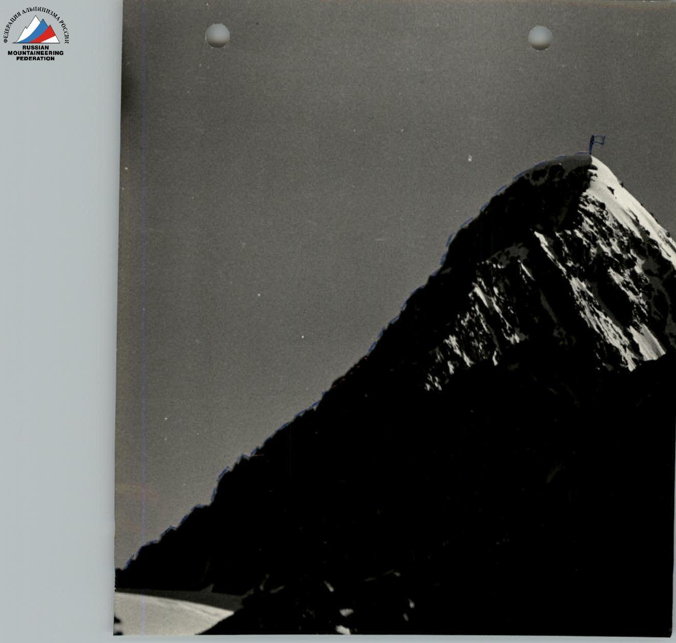
 ridge of peak Ayuter from Prizyvnik pass (Shot from GTO glacier)
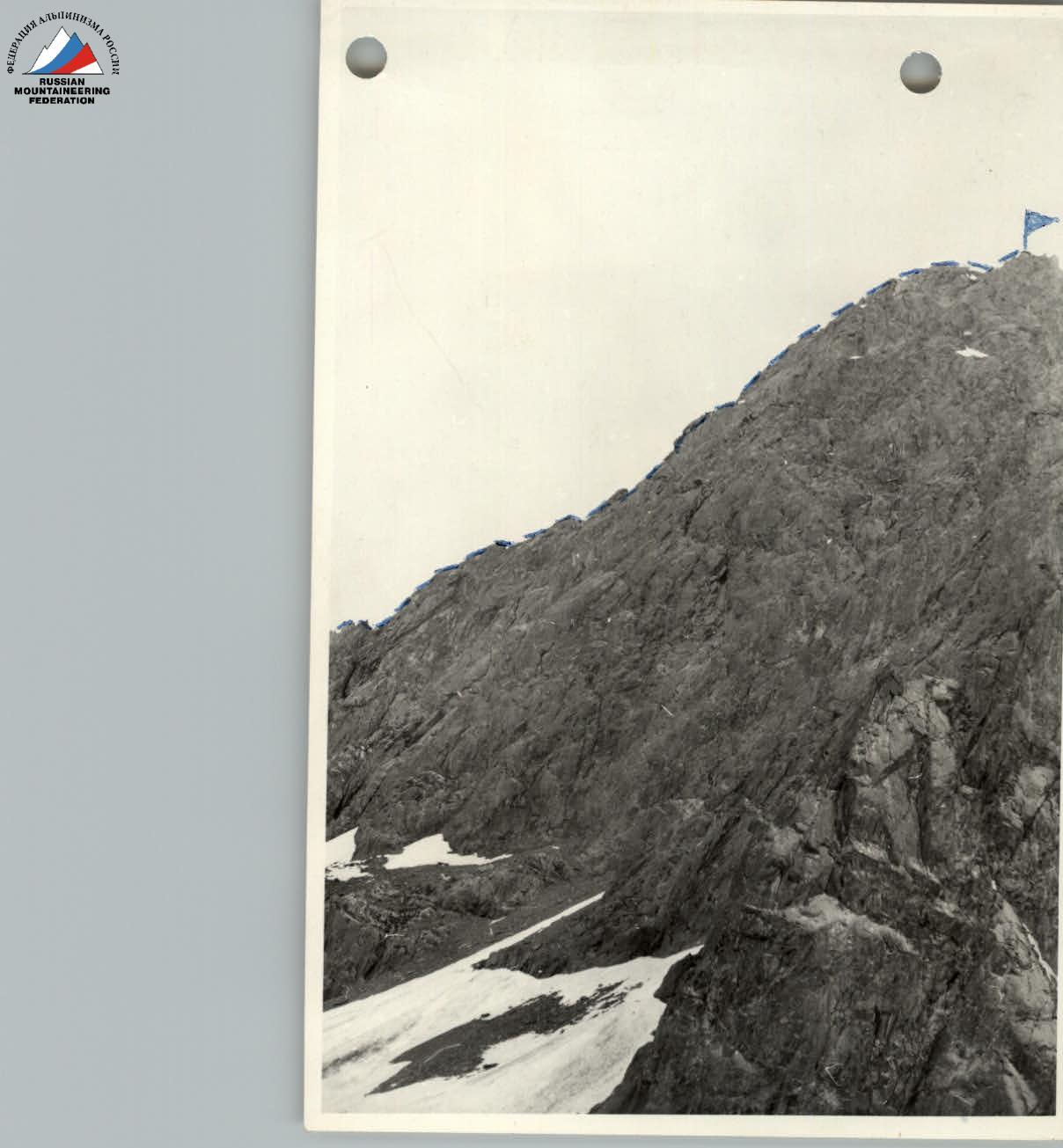 ridge of peak Ayuter from Prizyvnik pass (shot from north-eastern ridge)
Comments
Sign in to leave a comment