Ascent Passport
- Ascent class — technical
- Ascent area — Central Tien Shan, Terskey Ala-Too ridge, Jety-Oguz gorge
- Summit — Pik Chernyy Klyk, 4255 m, ascent route via North-Eastern ridge
- Estimated difficulty category 2B
- Route characteristics: height difference — 576 m, length of sections III–IV difficulty category — 830 m, average steepness 50°
- Pitons driven: rock protection — 14, ice — 0, bolt — 0
- Number of climbing hours — 9
- Number of nights and their characteristics — 0
- Surname, name, patronymic of the leader, participants, their qualification: AL'KOV Yuriy Yevgen'yevich — leader, 2nd sports category; YEVSEENKO Tat'yana Pavlovna — participant, 2nd sports category; Teslenko Sergey Tikhonovich — participant, 2nd sports category
- Team coach — BIRYUKOV V.N.
- Date: departure on route — July 25, 1978
return from route — July 25, 1978
Brief description of approaches to the route
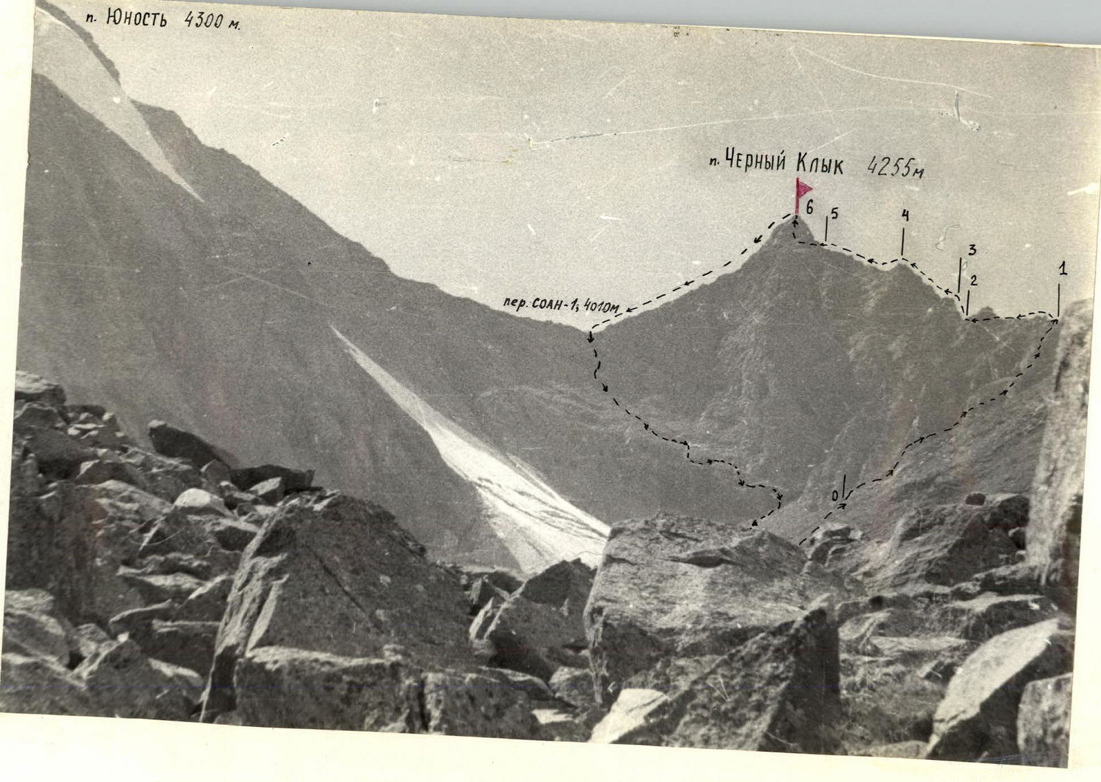
Pik "Chernyy Klyk" — 4255 m. (The height of the summit is given based on a 1:100000 scale topographic survey). Located in the northern spur of the Terskey Ala-Too watershed ridge above the source of the left component of the Jety-Oguz river — Baytor river, in the right part of the Baytor gorge (see map).
From the city of Przhevalsk by bus to the Jety-Oguz resort, then along the Jety-Oguz gorge to the Telety gorge by road.
Then on foot up the gorge to the fork to the Baytor gorge.
Cross the Jety-Oguz river by fording to the left bank, then by log to the left bank of the Baytor river at the fork. It is possible to cross the Jety-Oguz river at the Telety camp.
Along the Baytor gorge to the fork, then along the left bank of the Baytor river ascend to the Baytor camp.
From Telety to Baytor camp:
- movement is everywhere along the horse trail and tourist trail;
- time on the way — 4–5 hours with full backpacks.
The camp has clean water and good grassy areas. The route is not visible from the Baytor camp.
From the camp:
- through the left tributary of the Baytor river we exit to the moraine sloping dumps of the unknown ridge;
- we traverse them, ascending up the gorge;
- we cross the right arm of the Baytor river by fording and ascend up the scree slopes of the gorge.
The route is accessed via scree.
Approach time is:
- 2 hours by car;
- 7–8 hours to the route.
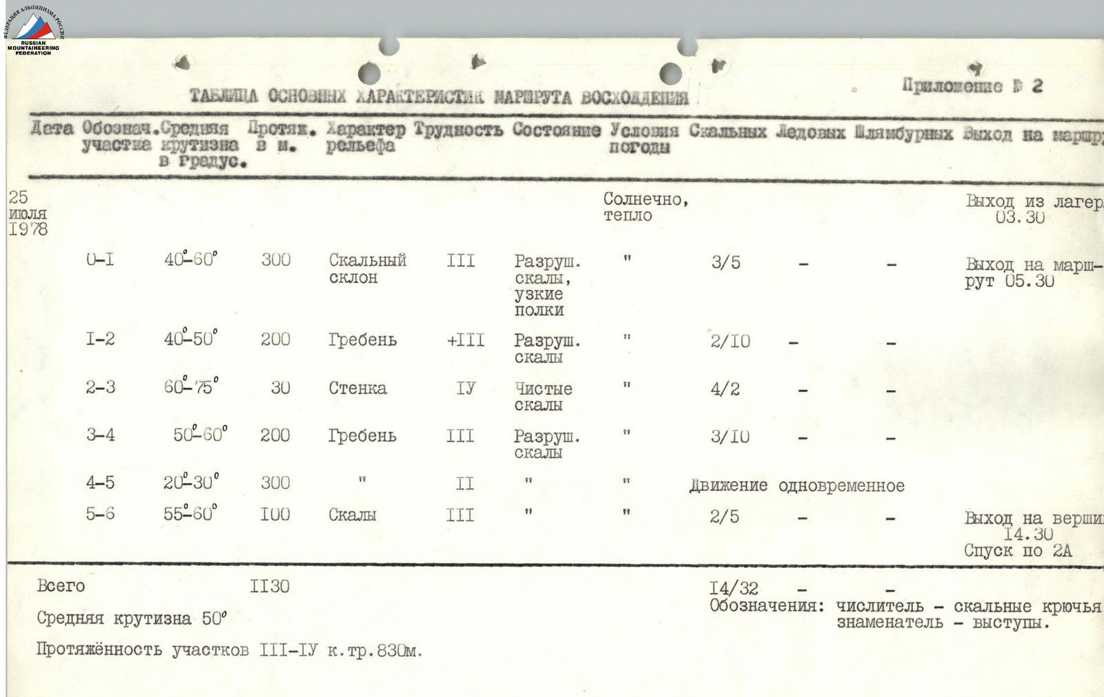
Table of main characteristics of the ascent route
| Date | Label | Average steepness | Length, m | Relief type | Difficulty | Condition | Weather conditions | Rock pitons / ledges | Ice pitons | Bolt pitons | Notes |
|---|---|---|---|---|---|---|---|---|---|---|---|
| July 25, 1978 | Sunny, warm | Departure from camp 03:30 | |||||||||
| O-1 | 40–60° | 300 | Rocky slope | III | Destroyed rocks, narrow shelves | " | 3/5 | — | — | Arrival at route 05:30 | |
| 1-2 | 40–50° | 200 | Ridge | +III | Destroyed rocks | " | 2/10 | — | — | ||
| 2-3 | 60–75° | 30 | Wall | IV | Clean rocks | " | 4/2 | — | — | ||
| 3-4 | 50–60° | 200 | Ridge | III | Destroyed rocks | " | 3/10 | — | — | ||
| 4-5 | 20–30° | 300 | Ridge | II | Destroyed rocks | " | Simultaneous movement | ||||
| 5-6 | 55–60° | 100 | Rocks | III | Destroyed rocks | " | 2/5 | — | — | Arrival at summit 14:30. Descent via 2A | |
| Total | 1130 | 14/32 | — | — |
Average steepness 50° Length of sections III–IV difficulty category 830 m. Notation: numerator — rock pitons, denominator — ledges.
Brief explanation of the table
O-1. We ascend to the ridge along rocky shelves through the black wall, bypassing small gendarmes and couloirs. 1-2. Along the ridge to the left. The first gendarme is bypassed on the right, all the others on the left. 2–3. The section is a climb to a gendarme. At the beginning of the section, the wall has a steepness of 75°. 3–4–5. Movement along the ridge. 5–6. Ascent to the summit along steep rocks. When ascending to the summit, we move to the left.