
Ascent Passport
- Ascent class — altitude-technical
- Ascent area — Central Tien Shan
- Khan-Tengri peak (6995 m) — via the western couloir, first ascent
- Estimated complexity category — 5B
- Height difference — 2800 m
of which:
- wall — 1200 m
- Length — about 6000 m, including rock part — about 1800 m
- Length of sections with 5–6 complexity category — 125 m
- of which 6 complexity category — 15 m
- Average steepness of the rock part — 49°
-
Pitons driven rock 9/2, chocks 16/1, ice 2/0
-
Team's man-hours — 39 (4 days)
-
Overnights — 3, lying in a tent
-
Team of ak "Bars", St. Petersburg
-
Team leader — Shamalov Valery Pavlovich — Master of Sports
Participant — Komarov Dmitry Vladimirovich — 1st sports category
-
Team coach — USSR Master of Sports Krasnoukhov Yuri Vasilyevich, USSR Master of Sports Stepanov Igor Vasilyevich
-
Departure to the route — August 17, 1997
Summit ascent — August 19, 1997, return — August 20, 1997
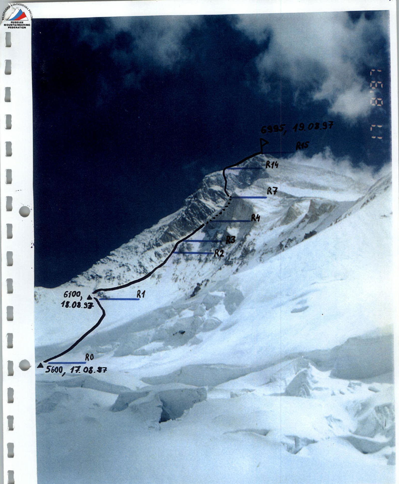
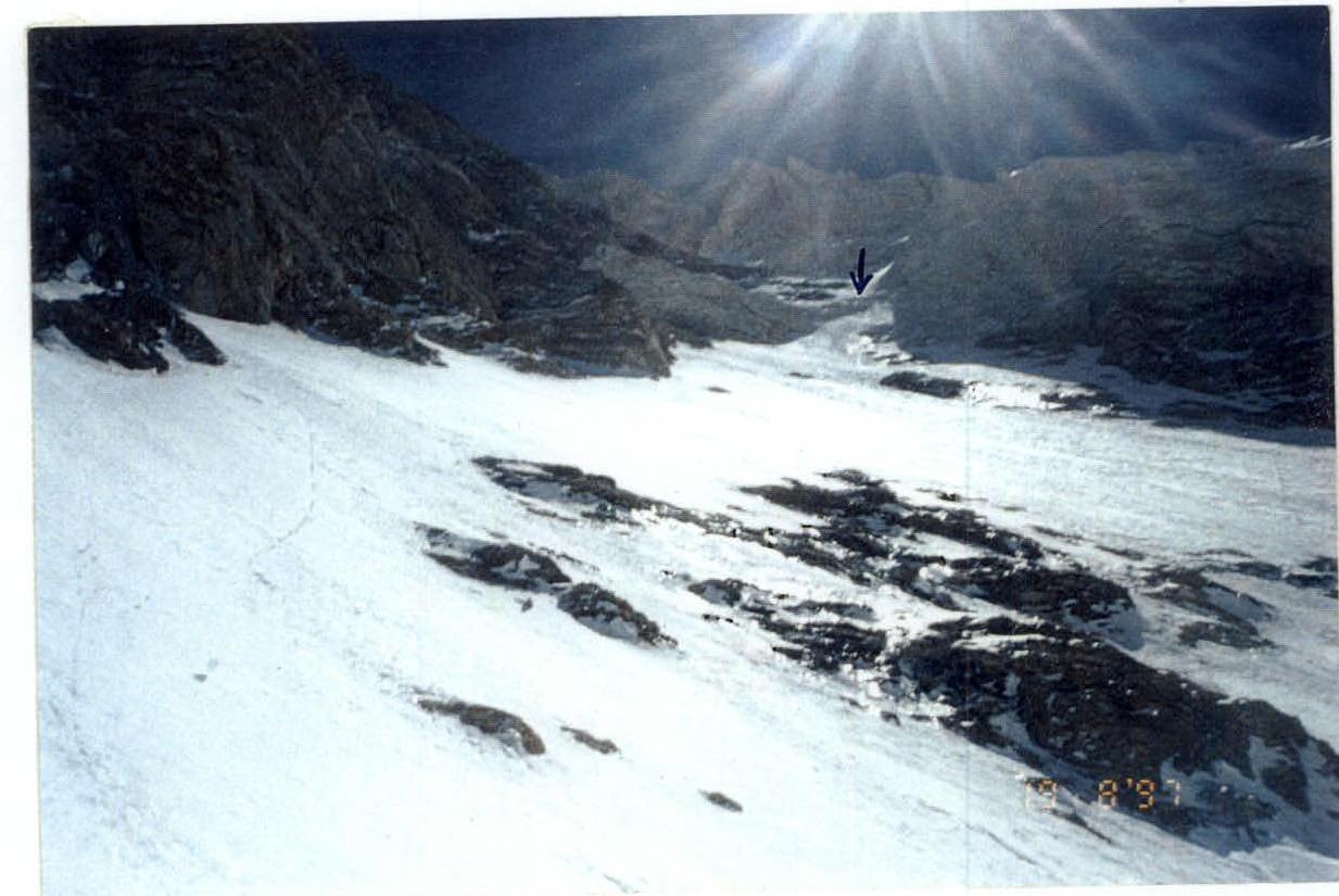
Photo date — August 17, 1997, photo height — 5300 m, route to Khan-Tengri peak (6995 m) via the western couloir, 5B complexity category, climbed by the duo V. Shamalov (St. Petersburg) — D. Komarov (Moscow). Team of ak "Bars", St. Petersburg.
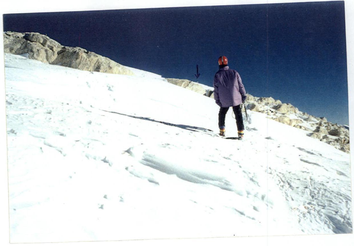
Dima Komarov 30 m from the summit.
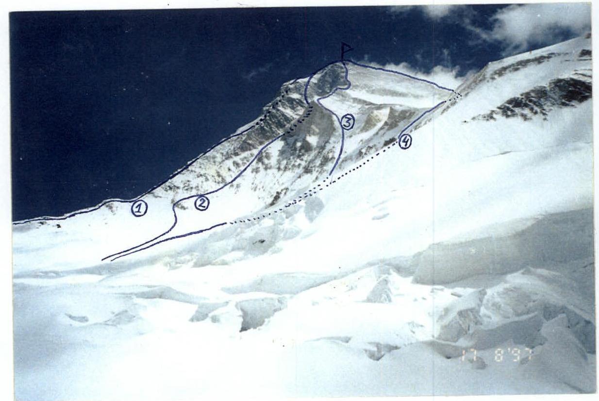
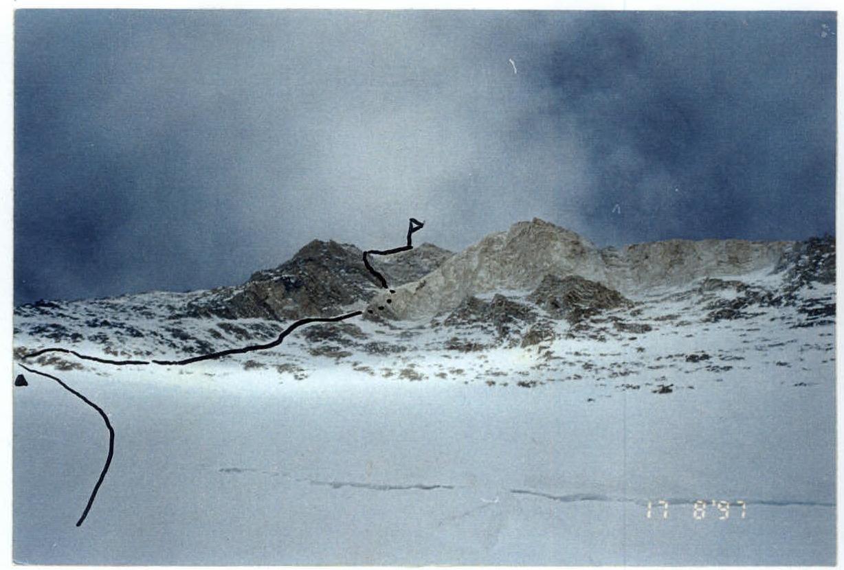
- 1st route Pogrebetsky (classic) via West Ridge 5A complexity category
- II-nd route of ak "Bars" team via the western couloir (presumably 5B complexity category)
- III-rd route of Ukrainian climbers (unclassified)
- IV-th route Romanov via SW ridge 5B complexity category

View of the lower part of the couloir from the classic route, height 6100 m
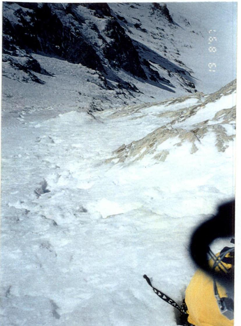
View down from section R3
Section R3
After section R3 — a few meters of very unpleasant smooth rocks (in the center of the photo).
Team's route from 5600 m height
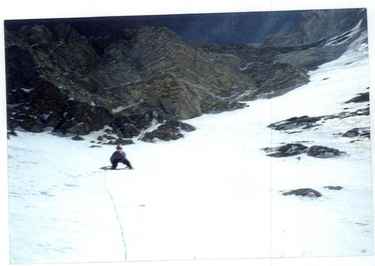
Searching for Krasnoukhov
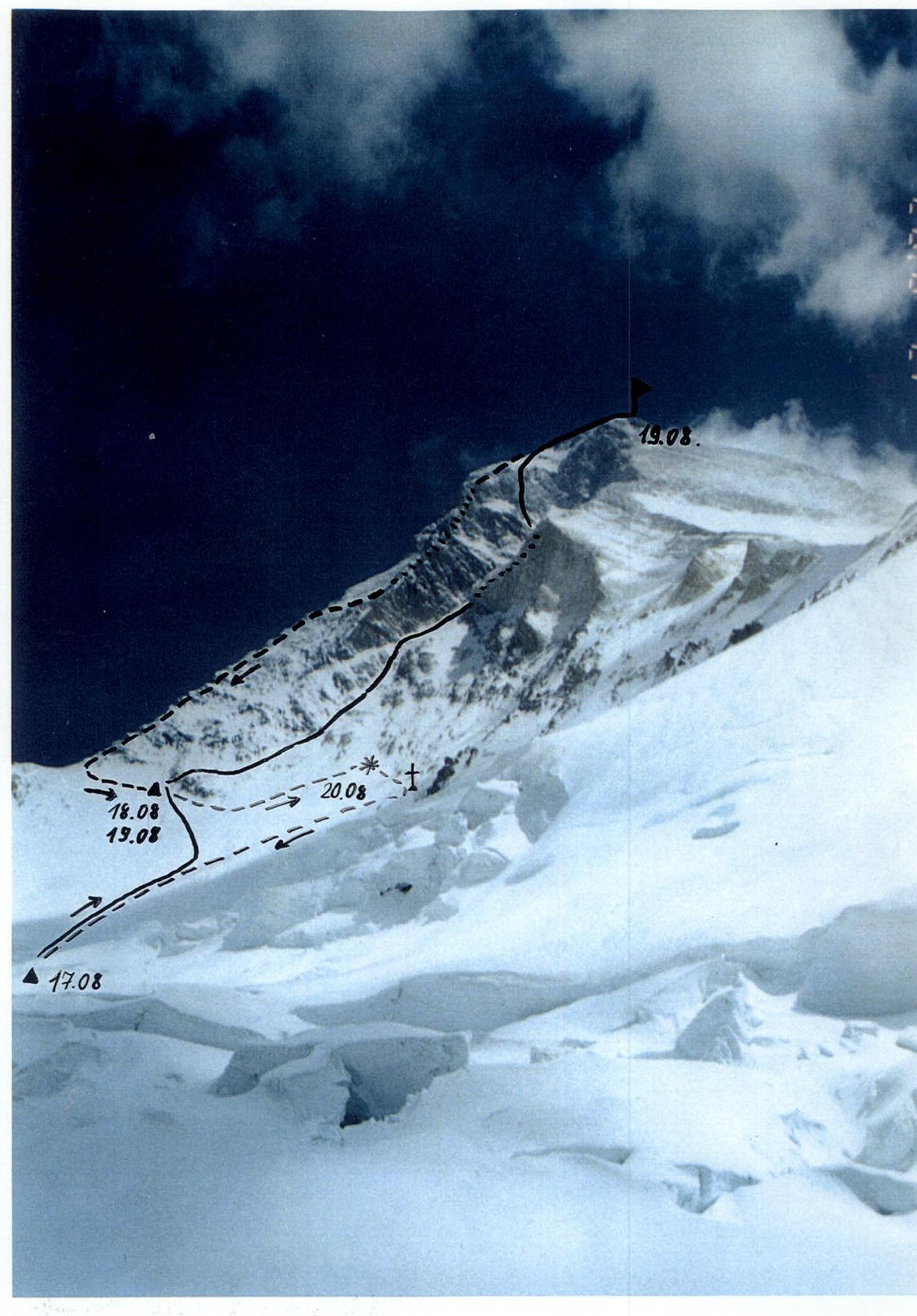
Tactical Actions of the Team
The team left the base camp on August 16. The deadline was set for the 20th. During the search, a duo Devyatkin — Gelinsky (doctor) was located at the camp at 5300 m, able to go on the route if necessary. The team and the observation group had communication via a spyglass. It was decided: in case of finding the body, the ascent would be stopped, the body would be secured in a safe and convenient location, and the team would descend.
August 16: Preparation of equipment and supplies, approach to the start of the route (moraine under the SW wall of Khan-Tengri).
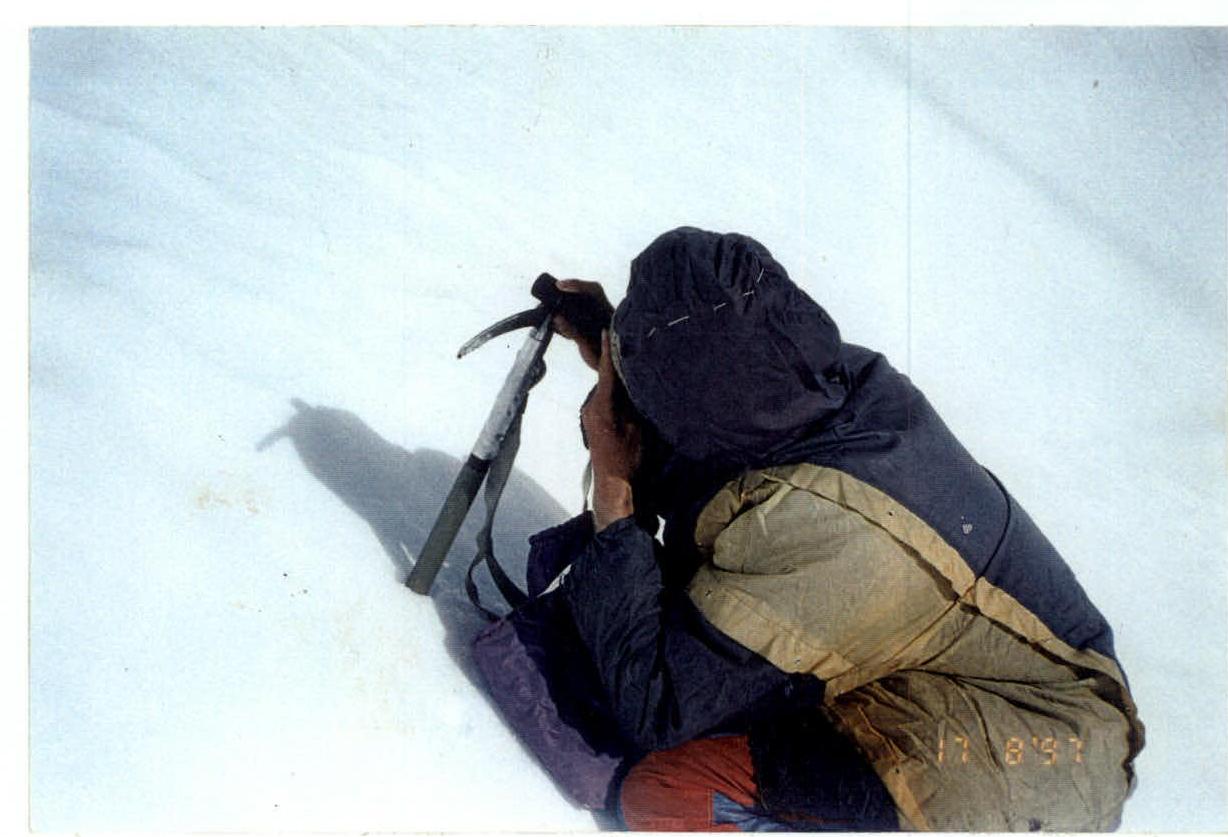
August 17: Having climbed along the trail to a height of about 5400 m, we turned right, towards the couloir. Setting up a tent at a height of 5600 m, we made an exit towards the western ridge. On the plateau, we found some of Krasnoukhov's belongings.
August 18: We began the ascent towards the couloir. We conducted a search using a spyglass, dividing the slope into squares and noting suspicious points on the snow. We moved in wide, smooth zigzags. On this day, we mostly encountered stones stuck in the snow. By evening, the weather began to deteriorate, and we decided to move out from under the couloir to the left, towards the classic route, to avoid spending the night in an avalanche-prone zone. In the evening, at 5400 m, a duo of observers appeared. Being at a height of about 6000 m, we managed to hear that they were shouting:
— "Is everything okay?" — "Yes", we shouted back with all our might.
August 19: The last day of the search. Tomorrow morning, the food and gas will run out, and in the evening, the deadline will be reached. We decided to leave the tent on the slope at a height of about 6100 m. From this place, it's easy to get to the classic route, and thus, having reached the summit, we can, if necessary, descend along the classic route to the abandoned tent even at night.
The weather was good in the morning, and we took a risk, leaving our backpacks, and climbed the couloir, taking snacks, rock and ice equipment, and a small first-aid kit. To avoid losing height, we went along the rock islands to the right and slightly upwards and thus bypassed a section of the slope on the left at a height from 6100 to 6300 m. Later, looking through the spyglass, we noticed several suspicious places but decided to examine them the next day while descending, and for now, to continue upwards.
The steepness of the slope gradually increased from 40 to 45–50°. We often encountered very unpleasant places where a thin layer of snow covered smooth rocks. In the middle of the couloir, we had to pass through a dense snow river formed by wind-blown snow. The weather was perfect! Obviously, with even a slight snowfall, the couloir becomes impassable. In the middle of the couloir, there is a rock belt. We had to climb just about 5 m of smooth rocks without footholds, complexity 5. About 20 meters below the rock belt, we managed to drive in a piton.
Further, from a height of 6600 m, it's easy to move to the right, onto the "Ukrainian" ridge. But from the couloir, it seems that all the difficult sections on this ridge are in the upper part. Besides, we didn't need to go there. In the upper part, the couloir starts to flatten out a bit — to 40–45° and turns into a large cirque, the walls of which are from 150 to 300 m high and have approximately the same steepness and complexity in all directions. It was logical to exit from there to the left, in the direction of the "classic" edge. From the beginning of the couloir to a height of 6600–6700 m, it's practically impossible to move to the left.
300–400 m before the end of the couloir, we turned left onto a steep (up to 55–60°) snow ascent, and then climbed onto a rock wall. We passed 3 ropes (fixed ropes) along snow-covered rocks, in places up to 6 complexity category, came out onto a snow slope and, after another 50 m, onto the classic route, near the place where the continuous fixed ropes end. Not far from here, our senior coach made his last overnight stay.
At 7:00, we reached the summit and retrieved a note from Novgorod climbers. At 22:00, in the dark, we descended to our tent. We didn't find any signs of Krasnoukhov's fall on August 19.
August 20: Before returning, we decided to examine the last section of the slope that we had bypassed during the ascent. At a height of 6200 m, we found Krasnoukhov's body, which we moved 300 m to the right and slightly down to remove it from under the couloir, and secured it with a rope under a rock triangle. On the same day, we managed to descend to the base camp.
In October 1997, an expedition led by Stepanov I. V. brought the body of Yu. V. Krasnoukhov to St. Petersburg.
Route Description
- Sec. 0–1 Slope with deep snow. Movement without insurance. 700 m 40°, 1
- Sec. 1–2 Snow slope with rock outcrops. Simultaneous or alternating movement with insurance through outcrops. 450 m 45°, 2–3
- Sec. 2–3 Snow-ice slope. Insurance through ice axe and ice screws. Alternating movement. 100 m 50°, 4
- Sec. 3–4 Couloir. Snow slope. Simultaneous movement. 200 m 45°, 3
- Sec. 4–5 Rock belt. Fixed ropes. Insurance through piton. Smooth rocks. 5 m 65°, 5
- Sec. 5–6 Couloir. Snow slope. Simultaneous or alternating movement. Insurance through ice axe. Rocks under snow. 250 m 50°, 3
- Sec. 6–7 Cirque. Snow slope. Simultaneous movement. 100 m 40°, 2
- Sec. 7–8 Steep snow ascent. Rocks under snow. Insurance through ice axe, pitons, chocks. Fixed ropes. 120 m 60°, 5
- Sec. 8–9 Destroyed rocks. Insurance through pitons, chocks. Fixed ropes. 40 m 70°, 5
- Sec. 9–10 Rock wall. Insurance and artificial holds through pitons, chocks. 10 m 85°, 6–A2
- Sec. 10–11 Rock wall. Insurance through chocks. Fixed ropes. 30 m 75°, 5
- Sec. 11–12 Rock wall. Insurance and artificial holds through pitons. Fixed ropes. 5 m 90°, 6–A1
- Sec. 12–13 Destroyed rocks. Insurance through chocks. Fixed ropes. 35 m 70°, 5
- Sec. 13–14 Snow slope. Insurance through ice axe. Alternating movement. 50 m 50°, 4
- Sec. 14–15 Snow ridge. Movement without insurance. 500 m, 20–30°, 1
The route is objectively hazardous. With deteriorating weather and snowfall, avalanches start to come down the couloir. There are no safe places to overnight from a height of 6100 m (away from the couloir) to exiting onto the ridge (6850–6900 m). In extreme cases, it's possible to move to the right ridge from a height of 6600 m and return to the couloir the next day or continue along the "Ukrainian" ridge. Throughout the entire route, it's difficult to organize reliable insurance. In the couloir, rocks under snow are constantly encountered. The upper rock belt consists of very destroyed and loose rocks.
Route Diagram in UIAA Symbols
| Pitons | Sec. N | Length (m) | Steepness (°) | Complexity | |||
|---|---|---|---|---|---|---|---|
ROCK | CHOCKS | ICE | ROPES | ||||
| – | – | – | – | 14 | 500 | 20–30 | 1 |
| – | – | – | – | 13 | 50 | 50 | 4 |
| – | 5 | – | – | 12 | 35 | 70 | 5 |
| 3/1 | – | – | – | 11 | 5 | 90 | 6–A1 |
| – | 3 | – | – | 10 | 30 | 75 | 5 |
| 1/1 | 3/1 | – | – | 9 | 10 | 85 | 6–A2 |
| 2 | 3 | – | – | 8 | 40 | 70 | 5 |
| 2 | 2 | – | – | 7 | 120 | 60 | 5 |
| – | – | – | – | 6 | 100 | 40 | 2 |
| – | – | – | – | 5 | 250 | 50 | 3 |
| 1 | – | – | – | 4 | 5 | 65 | 5 |
| – | – | 2 | – | 3 | 200 | 45 | 3 |
| – | – | – | – | 2 | 100 | 50 | 4 |
| – | – | – | – | 1 | 450 | 45 | 2–3 |
| – | – | – | – | 0 | 700 | 40 | 1 |

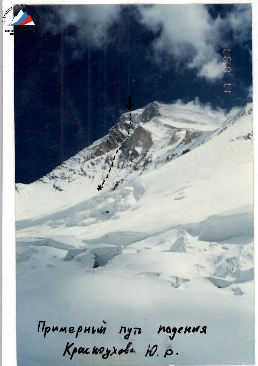
Approximate path of Krasnoukhov Yu. R.'s fall