7.8.4
Route Description
TO PEAK ODINNADЦATI (northeastern summit) 5437 m.
Brief geography of the area. Peak Odinnadцati is located in the area of the "Zapadny Bayankol" glacier on the Sarydzhas ridge, between Peak Bayankol and an unnamed peak located northwest of Peak Semenov.
The massive glaciations in this area drain into the "Zapadny Bayankol" glacier and from the southeastern slopes into the Severny Inylchek glacier. The northeastern summit of Peak Odinnadцati is predominantly snow-ice in character. Strong winds, blowing mostly from the southwest, form huge cornices on the ridge of the peak, overhanging the northwestern slopes.
The ascent was first made by athletes from the Kazakh Alpine Club led by U. Usenov in August 1957.
The group consisted of ten climbers, divided into five teams:
- U. Usenov — Domianiди Я.
- Brega M. — Tagabergenov M.
- Kaveshnikov Yu. — Tarasenko
- Gonyalin G. — Dubodenko E.
- Nebogin E. — Vododokhov A.
Approach. You can drive to the former village of Dzhar-kulak by Gaz 63 car, leaving the Bayankol settlement. From here, a trail leads to the upper reaches of the Bayankol glacier. The winding trail passes:
- along the steep right (orographic) bank of the Sary-Koynou river,
- and crosses wide grassy terraces.
We set up the first camp 10-12 km from Dzhar-kulak. From here, having crossed to the left (orographic) bank of the river at its upper reaches, we move southwest. 200 m later, we cross the left tributary of the river.
Diagram of the route to "5437 m" peak (Odinnadцati) (northeastern summit).
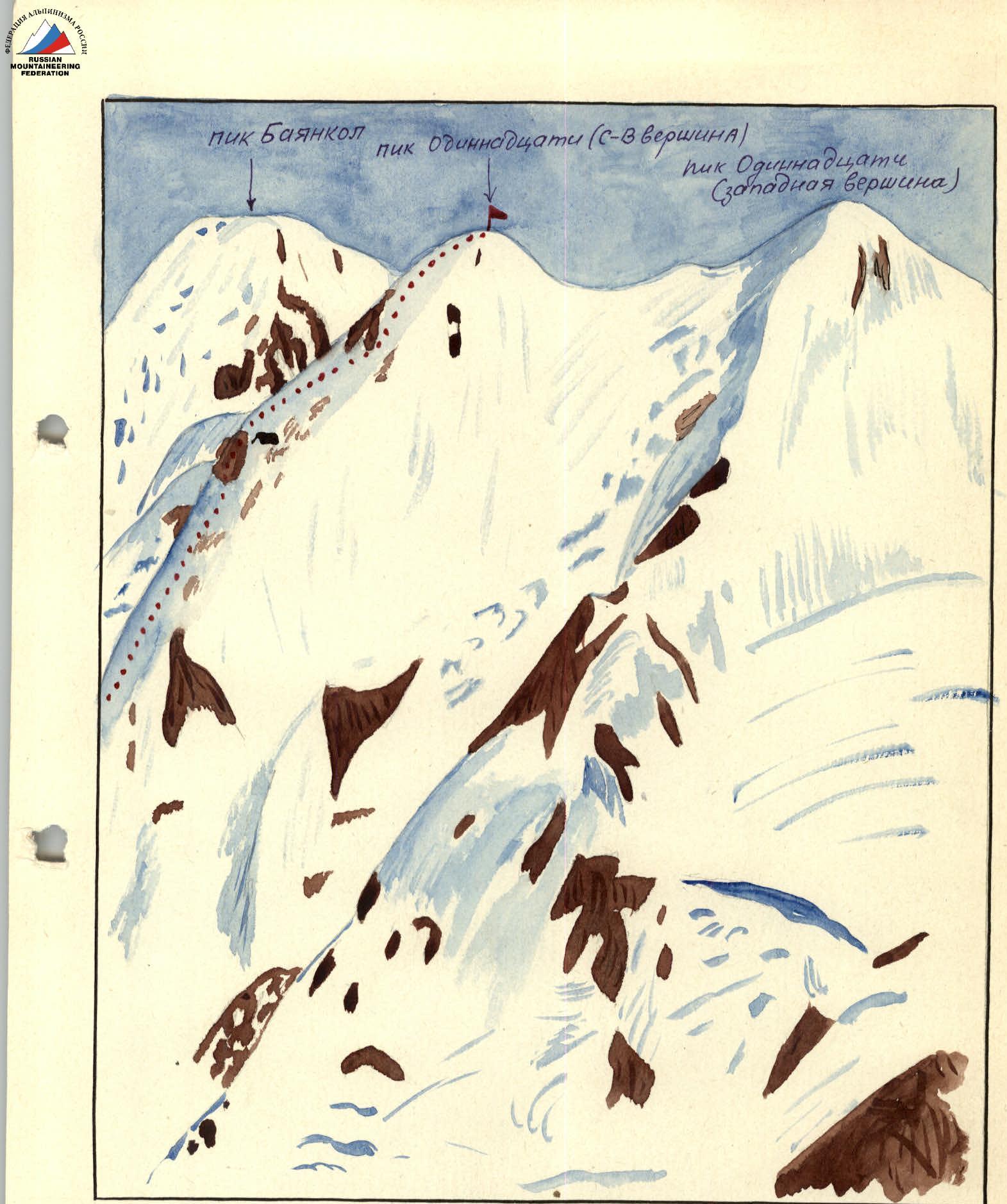
To the right, the spurs and slopes of the 4302 m peak descend. To the left, behind the moraine ridges, Peak Bayankol rises.
We come out onto the lateral moraine of the "Zapadny Bayankol" glacier. The moraine steeply breaks off into the glacial hollow. We walk for about an hour along it, where steep glacier slopes are on the left, down which huge stones continuously roll. You need to move carefully here.
Having climbed up, on the right-bank grassy terrace of the southeastern slopes of the unnamed peak at an altitude of 3660 m, we set up a base camp.
Ascent:
- Early in the morning of the next day, we leave the base camp.
- Having descended into the lateral hollow of the "Zapadny Bayankol" glacier, we climb up 50 m with the help of piton belay along the steep slope of the glacier and come out onto the glacier.
- Having walked 300 m south along the glacier, we turn southeast and, within 15 minutes' walk, cross an ice crevasse with belay and move to the right (orographic) side of the glacier.
- Here we put on high-altitude footwear and continue on.
- Moving along the glacier, after 1.5 hours we approach the foot of the northwestern ridge of Peak Odinnadцati.
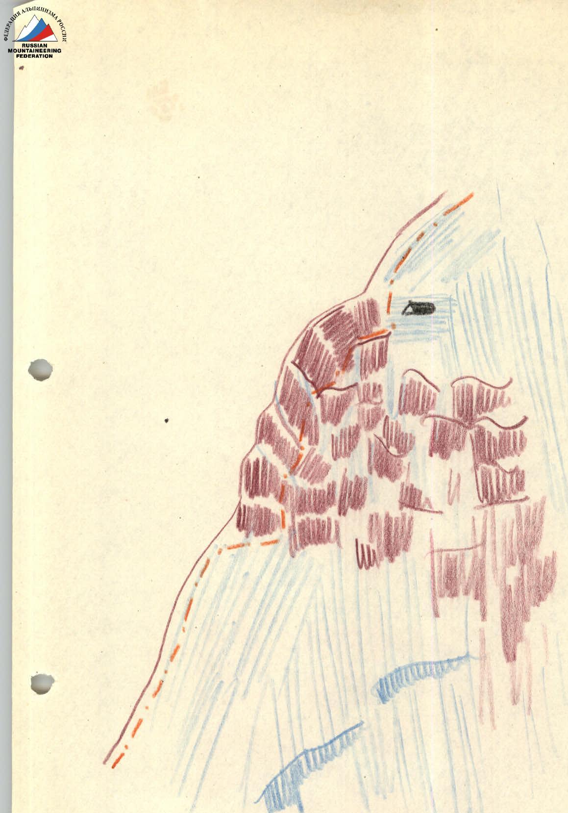
A wide and deep crevasse prevents access to the ridge; it is impossible to bypass it. The narrowest place is 6-7 m wide and up to 40 m deep (fig. 1). With the help of thorough piton belay and organized ropes, we descend to the bottom of the crevasse and then, with step cutting and piton belay, we climb out to the other side of the crevasse. Overcoming this bergschrund took us 3 hours.
For some time, we move along the edge of the crevasse, 3-4 meters above it. Two more semi-closed crevasses run parallel to the first crevasse:
- the first one;
- the second one.
We overcome the second crevasse on a narrow thin snow bridge (prone) with careful belay through an ice axe.
We overcome the third crevasse by descending into it and climbing up its opposite wall, with step cutting and using the highest alpine technique. The depth of the third crevasse is 25-30 m.
Further, there is a steep snow slope (avalanche-prone), leading to an indistinct ridge. 200 m later, the steepness of the slope gradually decreases, turning into a snow plateau 100×150 m in size. This snow plateau abuts the ridge. At its foot, we set up a bivouac.
Having reached the ridge the next day, which is initially snow-covered, higher up it turns into rock. A section of the ridge with destroyed rocks stretches for no more than 100 m, and then the ridge becomes snow-covered again. To the left, cornices overhang to the north. We move in a rope team, carefully bypassing the corniced part of the ridge.
There are several small areas with destroyed rocks on the ridge. The steepness of the ridge:
- then increases,
- then passes into a saddle.
Approximately at an altitude of 500 m on the ridge, there is a section of ice-covered rocks of medium difficulty (fig. 2). Having overcome them, we stop for the night.
From here begins the most difficult section of the route, all the way to the summit. A wide and steep ridge with powdery deep snow presents a serious obstacle. The slopes are avalanche-prone. The steepness of the ridge reaches 70-75° in the upper part over 10-11 ropes (fig. 3).
Here we move with alternating belay, using ropes, and reach the summit. The height of the summit according to the altimeter is 5600 m.
The descent from the summit is made along the ascent route.
The group believes that Peak Odinnadцati belongs to peaks of 3B category of difficulty.
Description compiled by: (M.S. Brega)
We agree with the description:
(A. Vododokhov)
(Yu. Kaveshnikov)
(U. Usenov)
True to the original: [Signature]