
Report
On the ascent of the team of climbers of the Novosibirsk regional council of the SDSO "Burevestnik" to the peak Choktal (1st Eastern) via the North wall (approximately 5-6 cat. diff.)
1. Characteristics of the region and the object of ascent.
The North wall of the 1st Eastern peak of the Choktal massif was chosen as the object of ascent by the team of the Novosibirsk "Burevestnik" for participation in the CS championship in 1965.
The Choktal massif is located in the ridge of the North Tian-Shan, Kungay-Alatau, and is its most elevated part. The main peak of the massif - 1st Eastern - has a height of 4770 m.
The northern slopes of the massif limit the wide valley of the Chon-Kemin river, along which a good road is laid, allowing easy access to the Choktal area. (The Chon-Kemin valley is a place of intensive sheep farming, which explains the presence of a good road and a large number of passing vehicles.)
The nearest settlement - Novorossiika village - is located 35 km downstream. The journey from Frunze by car takes 12-15 hours.
The area is characterized by unstable weather, which is apparently due to the proximity of Issyk-Kul. For example, during the ascent, out of 9 days:
- 5 days had thunderstorms in the middle of the day (usually from 13:00 to 17:00),
- 1 day was foggy,
- 1 day had a blizzard.
The Choktal area has been visited by climbers since 1937, when an ascent was made to the 2nd Western peak. In 1950, ascents were made to the 2nd Western and 2nd Eastern peaks, and in 1956, a team from the Moscow Power Engineering Institute completed a full traverse of the massif, which was later repeated twice by groups of Kazakh and Kyrgyz climbers.
The problem of the North wall was first posed by the climbers of MPEI. However, although each of the aforementioned groups "observed" the wall, no serious attempts were made to ascend it. As a result, we heard the most contradictory opinions:
- some considered the wall extremely difficult (Master of Sports A. V. Sinkovsky, Master of Sports L. M. Kiselev),
- others considered it difficult but short and quite accessible (Master of Sports V. M. Alekseev).
This situation inevitably led to the North wall becoming a problem that attracted attention.
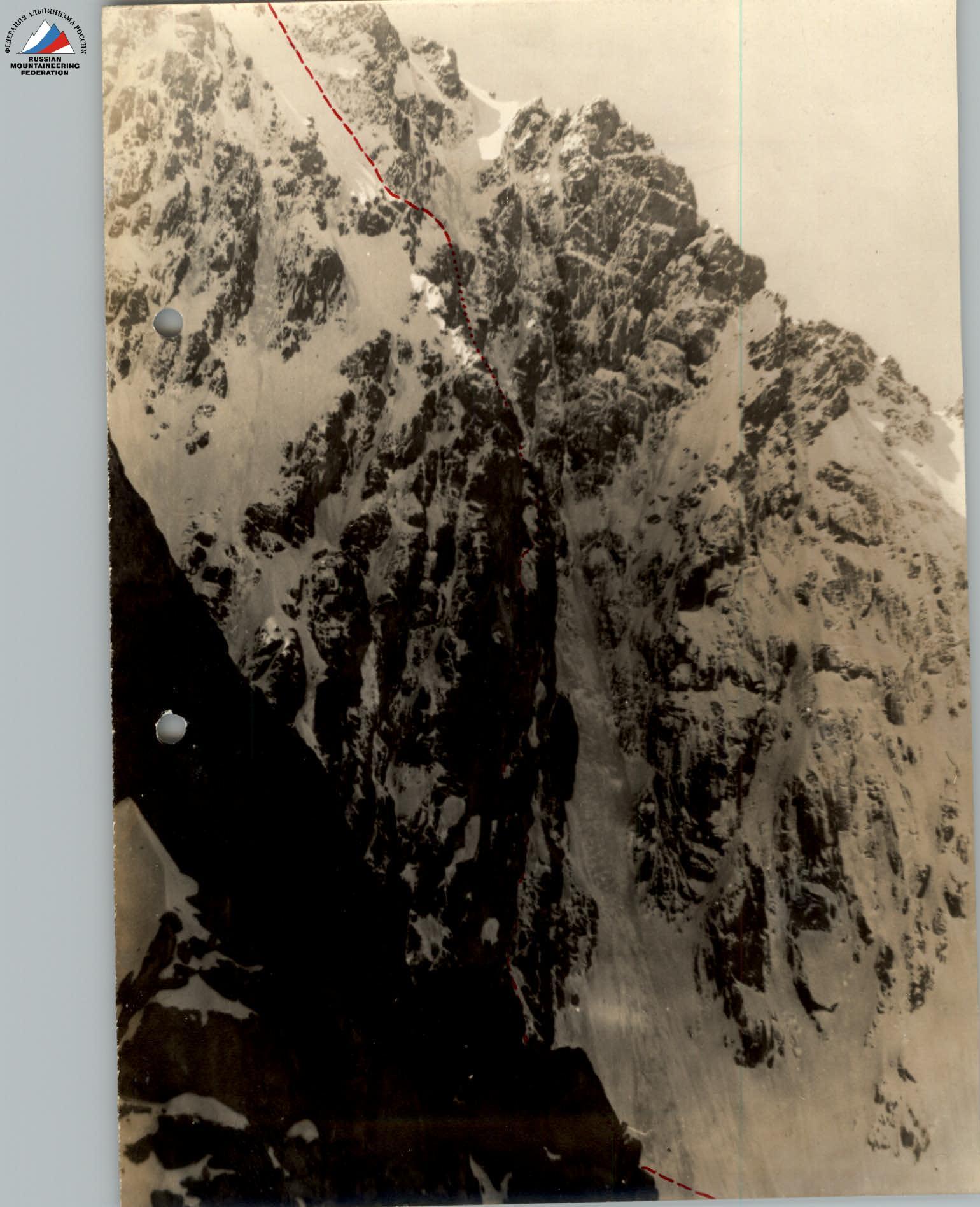
The wall consists of three roughly equal parts in length.
The lower part is a rocky massif with a large number of sheer and overhanging sections, rocks of a "tile-like" structure (unfavorable inclination of ledges), and heavily smoothed - an abundance of "mirrors".
The middle part is an ice slope with rocky inclusions-islands, shaped like the letter "V", ending in a rocky massif dissected by ice gullies and couloirs.
The upper part is a snow-ice slope ("board"). Everywhere, except for the "board", the ice is "natachenny" (formed by freezing water). As a rule, all rock ledges have a slope and are covered with natachenny ice.
The height difference, determined by us on a 1:100 000 scale map, and independently calculated after completing the route by the number of ropes and steepness, is 900 m.
The wall is sunlit (in August) from 14:00 to 20:00.
2. Reconnaissance and route selection.
The team of the Novosibirsk regional council of the SDSO "Burevestnik" arrived in the Choktal area as part of a combined team of the regional alpine federation, aiming to conduct the first independent trip to a remote high-mountain area for Novosibirsk climbers. It was planned:
- to conduct an ascent by the "Burevestnik" team;
- to traverse the massif (5B cat. diff.) by the "Trud" team;
- to make several ascents of 3-4 cat. diff. by participants of the auxiliary group.
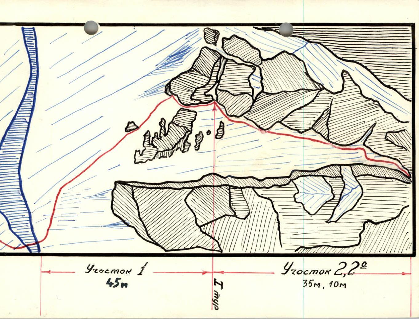
On August 8, the team arrived in the Choktal area and began to implement the program. The base camp was set up in the Chon-Kemin valley, near a stone kosh, next to which the Chon-Kemin river is joined by a spring.
The second possible location for the base camp is a clearing near the bridge over the Dzhindy-Su river, but it turned out to be inaccessible for a heavily loaded vehicle, and the gain in time spent on approaching the cirque of the 1st Eastern peak is not more than 30 minutes.
On August 10, a reconnaissance sortie was conducted by the entire team (19 people), allowing them to familiarize themselves with the area and outline the approach routes.
On August 11, the "Burevestnik" team, in the declared composition, set out to the cirque of the 1st Eastern peak of Choktal.
The best approach route is along the road leading up the Chon-Kemin valley; where the terrace ends and another spring flows, turn right and cross over into the Dzhindy-Su valley. Then, up along the orographic left bank of the Dzhindy-Su river to the confluence of the tributaries flowing from the glaciers:
- 1st Eastern Dzhindy-Su;
- 2nd Eastern Dzhindy-Su.
Here is a ford, from which a path leads along a gentle moraine to the glacier 1st Eastern Dzhindy-Su and along it to the cirque of the 1st Eastern peak of Choktal. The time spent on the approach is 4.5-5 hours.
On August 12, a storm camp was set up on the moraine of the 1st Eastern Dzhindy-Su glacier.
On August 13-14, observation of the wall and route selection took place. At 12:30 on August 13, a group of observers arrived at the storm camp, having previously made ascents to the 2nd Eastern and 2nd Western peaks of Choktal (3A and 4A cat. diff. respectively).
The composition of the observation group:
- Kiselev A. M. - 2nd sports category, group leader
- Grebennik K. V. - 1st sports category
- Mogilevsky E. A. - 2nd sports category
- Saratovkin V. D. - 2nd sports category
- Sobolev A. - 3rd sports category
- Panfilov L. I. - 3rd sports category, radio operator (stayed in the base camp from August 14 to 25)
- Ivanova T. - 3rd sports category, doctor
The composition of the observation group in the storm camp changed, but there were always at least three observers present. From August 18, the safety of the team on the wall was ensured by the team of the Novosibirsk regional council of the DSO "Trud" in the following composition:
- Seryogin A. N. - 1st sports category
- Martynov V. A. - Master of Sports
- Dobkin I. G. - 1st sports category
- Ivanova A. N. - 1st sports category
- Konovalov Yu. M. - 1st sports category
- Terletsky V. A. - 1st sports category
who successfully completed the traverse of the Choktal massif. Communication between the team and the observation group was carried out during the day by voice and in the evening at 21:00 daily by flares.
3. Ascent plan.
The only acceptable route for passing the wall, which is not a "bypass" of key sections, is the chosen route along a pronounced giant internal angle formed by overhanging "mirrors" on the left and a system of walls and inclined ledges on the right.
The most difficult section was expected to be the "red" and black "mirrors", which end the middle part of the wall. When viewing the route through binoculars, intensive pitonning was anticipated here.
The upper part - the "board" - was considered the clearest. Two options were planned for reaching it from the middle part - the "V":
- along the left edge of the ice with a climb to the ridge and exit to the "board";
- along the right side of the "V", with a passage "around the corner" and a climb along the ice gullies.
The first option seemed preferable when viewed from below, but in reality, the second option was used, as it was simpler.
The passage of the "board" was planned depending on the chosen route on the "V":
- in the first case, exit to the summit ridge along the middle of the "board" and along it to the summit;
- in the second case, along the right edge of the "board" to the right onto the counterfort and along it to the summit.
This variant was implemented.
The chosen route is not prone to rockfall: during the stay in the cirque and on the wall, not a single rockfall was recorded on the route.
The organization of bivouacs on the wall was considered the most problematic. Therefore, a plan was adopted that included:
- a day of preliminary processing,
- on the second day, an exit to a visible ledge ("plug"), suitable for overnight stay.
4. Team composition.
According to the application, the team consisted of 6 people:
| Name | Category | Experience in ascents of 5th cat. diff. |
|---|---|---|
| 1. Grebennik O. I. | 1st | Kara-Tau 5A, Taldysu traverse 5A |
| 2. Klimenko V. A. | 1st | Kara-Tau 5A, Taldysu main route via Pelevin 5B |
| 3. Menshikov V. F. | 2nd | Akkemskaia wall 5B, Taldysu traverse 5A, Kara-Tau 5A (leader) |
| 4. Meshkov I. N. | 1st | Kara-Tau 5A, Taldysu main route via Pelevin 5B, 4600 ("Trud") 5B, Taldysu traverse 5A (leader) |
| 5. Kovlyaev Yu. D. | 1st | Korona 6th tower 5A, Taldysu traverse 5A, Kara-Tau 5A (leader) |
| 6. Nelidov A. B. | 1st | Koshtan-Tau - peak Tikhonov 5B (leader), 12 × 5A |
Menshikov V. F., listed as a 2nd category climber in the application, completed the norms of the 1st sports category during training camps in Taldysu before arriving in the Choktal area (according to the new classification).
Papadichev V. A., listed as a reserve, was unable to participate due to work circumstances.
On the third day of the ascent, participants Nelidov A. B. and Grebennik O. I. were forced to descend due to Grebennik's cold.
5. Route passage and characteristics.
A significant difficulty encountered during the route was the abundance of natachenny ice, which filled all rocks with a steepness of less than 60°. What appeared to be snow ledges from below (see illustration M) turned out to be steep walls covered with natachenny ice. There is no snow on the wall, except for the "board" and a 20-meter ridge in the upper part of the "V" (section R11) - all white patches are ice. As a result, sections of complex rocks interspersed with ice had to be overcome in crampons (see, for example, photographs of sections R5 and R6).
The participant leading the way had to overcome sections R11 and R15 with an extremely lightened rucksack, and the rest of the sections without a rucksack. Sections R5, R8, R9, R9A, R10 had to be overcome without rucksacks by all team members. Pulling up rucksacks was significantly facilitated by the presence of a block taken for this purpose in the group.
The table below provides the main quantitative characteristics of the route sections and the conditions of their passage by the team. We will briefly describe the paths of their passage.
List of sections overcome without rucksacks by all team members:
- R5, R8, R9, R9A, R10.
From the storm camp, crossing the glacier under the slopes of peak Sibiriakademii, we reach the wall. We put on crampons and ascend a snow-ice slope with a steepness of 30° (30 m) to the bergschrund, which is overcome by a snow bridge.
Section R1. After crossing the bergschrund, we traverse left (2 ice pitons) to avoid a steep ice "nasplyv" and ascend a slope with a steepness of 50° on the front teeth with piton protection to the rocks at the left edge of the ice couloir.
Section R2. We ascend along the boundary of natachenny ice and rocks with step cutting and piton protection to a rock ledge. (Two people can stand here.) Here is the 1st control point. Then, we continue up along the boundary of ice and rocks to the narrowing of the couloir. We traverse right (5 m) under the ice overhang.
Section R2A ("icicle"). 10 m of sheer ice, framed by smoothed rocks on the right and left, are overcome by climbing along the angle formed by the ice and rocks (supports: on the left - steps cut in the ice, on the right - rock pitons).
Section R3. After crossing the "icicle", we ascend an ice slope to rocks of medium difficulty, leading to a ledge with a place for a sitting bivouac for four people. Here is the 2nd control point.
Section R4. From the ledge, we ascend along an ice ledge, steeply turning right and, after 15 m, again left. Steep natachenny ice. Steps.
Section R5. 15 m from the second turn, we reach a sheer rock wall limiting the ledge on the left. The wall has no holds, and climbing is done using ladders.
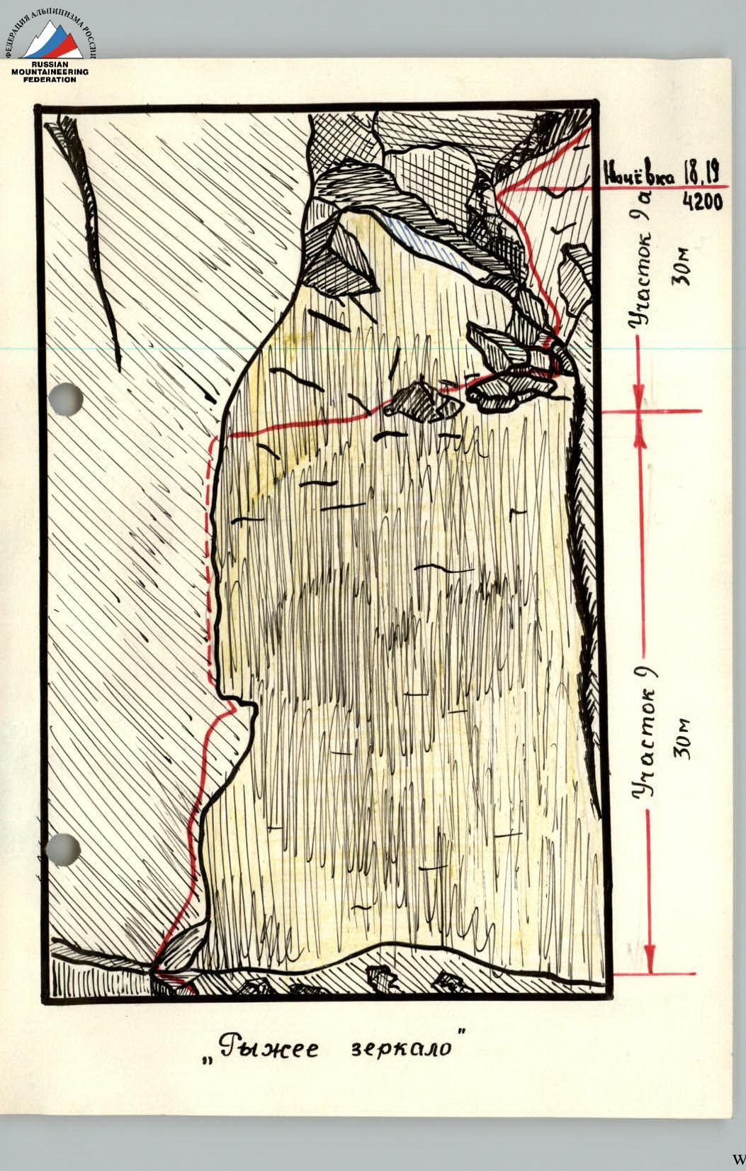
Section R5A. The steepness decreases to 70°. Rocks of medium difficulty, interspersed with natachenny ice. We reach the "plug": a huge ledge, clearly visible from below, which "locks" the angle. Here is a sitting bivouac.
Section R6. From the "plug", we ascend along slabs with a steepness of 80°-60° with sheer ledges of 1.5-2 m and natachenny ice. The slabs are heavily smoothed, with few cracks. Climbing is done using ladders.
Section R6A. From under the wall, we ascend left up a crack in the internal angle, which initially overhangs. We reach a ledge (ladders). To the left of it is a small "balcony" 0.5 × 2.5 m. Here, we manage to hang a tent, in which two people can lie with their feet towards each other. Two more people spend the night semi-reclining on the ledge.
Here is the 3rd control point.
Section R7. A ledge with natachenny ice (steps) leads under a sheer wall.
Section R8. Like on section R6A, to the left of the wall, there is a crack with outcropping rocks, which initially overhang. We ascend using climbing with piton protection. Due to the presence of outcropping rocks, sections with negative steepness can be overcome by free climbing.
Section R9. Above the crack, a short section of rocks of medium difficulty leads under the "red mirror" - a 30-meter sheer and completely smooth wall. On the left, there is a similar wall with a few cracks.
The section is overcome with a platform and ladders, initially along the left wall, along the crack in the internal angle. The rocks are negatively inclined.
After 6-8 m, we need to move into the crack, which widens enough to fit half of the torso. Movement is done using artificial supports. The rocks in the crack are loose, and for protection, we have to use:
- ice pitons,
- duralumin wedges.
In the upper part, where the crack widens, we need to traverse right on ladders to the wall of the mirror - Section R9A - and ascend along it to a small ledge under the "black mirror". This section is also overcome using ladders.
On the ledge, there is a sitting bivouac for two people (more precisely, a semi-hanging one).
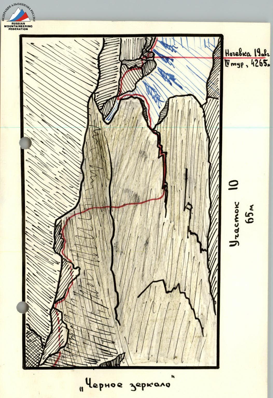
Section R10, "black mirror", is overcome along the angle between the mirror and the sheer wall on the left: initially by climbing with piton protection, and then using ladders. In the middle (by height) of the mirror, we need to traverse right on ladders to a vertical crack and then along it, wedging one leg into the crack. At the top of the mirror, before reaching the rock ledge, we had to drive a single shлямbur piton on the route.
Above the mirror, there is a ledge, somewhat more convenient for a sitting bivouac. Above it, rocks of medium difficulty (10 m) lead to an ice slope, framed by rock overhangs on the left and right, so that it looks like the letter V from afar.
On the ledge, there is the 4th control point.
Section R11. One rope can be passed on the front teeth, initially along the rocks on the left, and then traversing right (with step cutting) to a rock wall leading to a snow-ice ridge, and further up along it. Where the ridge ends with a rock wall, we manage to cut snow and ice and lay out a platform under 2/3 of a tent.
Section R12. To the right of the ridge, there are two parallel ice gullies-couloirs, separated by a rock massif. Crossing the first gully where it becomes less steep (steps), we reach an ice slope and ascend along it under rocks, leaving the second gully on the right. Then, we move along the sheer rocks (on the left) to the narrow throat of the second gully. Here is a complex section - 10 m of almost sheer ice. We ascend the gully with a traverse under the rocks on the right (here it is more gentle), and then again traverse left to the ice ridge above the rock massif separating the gullies.
Section R13. From the ridge, we ascend up a crack between a sheer wall on the left and smoothed rocks on the right.
Climbing is difficult. There are few cracks for pitons.
Above the crack, there is an ice slope leading under a rock wall. Here, on a ledge, we manage to organize a bivouac, lying one by one.
On the ledge, the 5th control point is left. Section R15, "board", is an ice slope covered with 15 cm of snow in the lower part. It is easy and confident to walk on the front teeth, with protection through rock and ice pitons.
Holding onto the rocks, we pass two ropes up, and then turn left - up to a rock island in the middle of the "board".
Above the island, the steepness of the "board" increases noticeably, and the snow becomes deeper and more loose. Still holding onto the rocks on the right, we reach a snow tongue branching off to the right and exit onto the counterfort limiting the "board".
It is worth noting that when moving along the "board", one should not hurry to move to the counterfort - it is very complex everywhere, except for the last ten meters under the pre-summit wall, which the "board" leads to.
Section R16: the pre-summit wall is overcome by free climbing with piton protection. This is a section of medium-strength rocks, difficult and of medium difficulty.
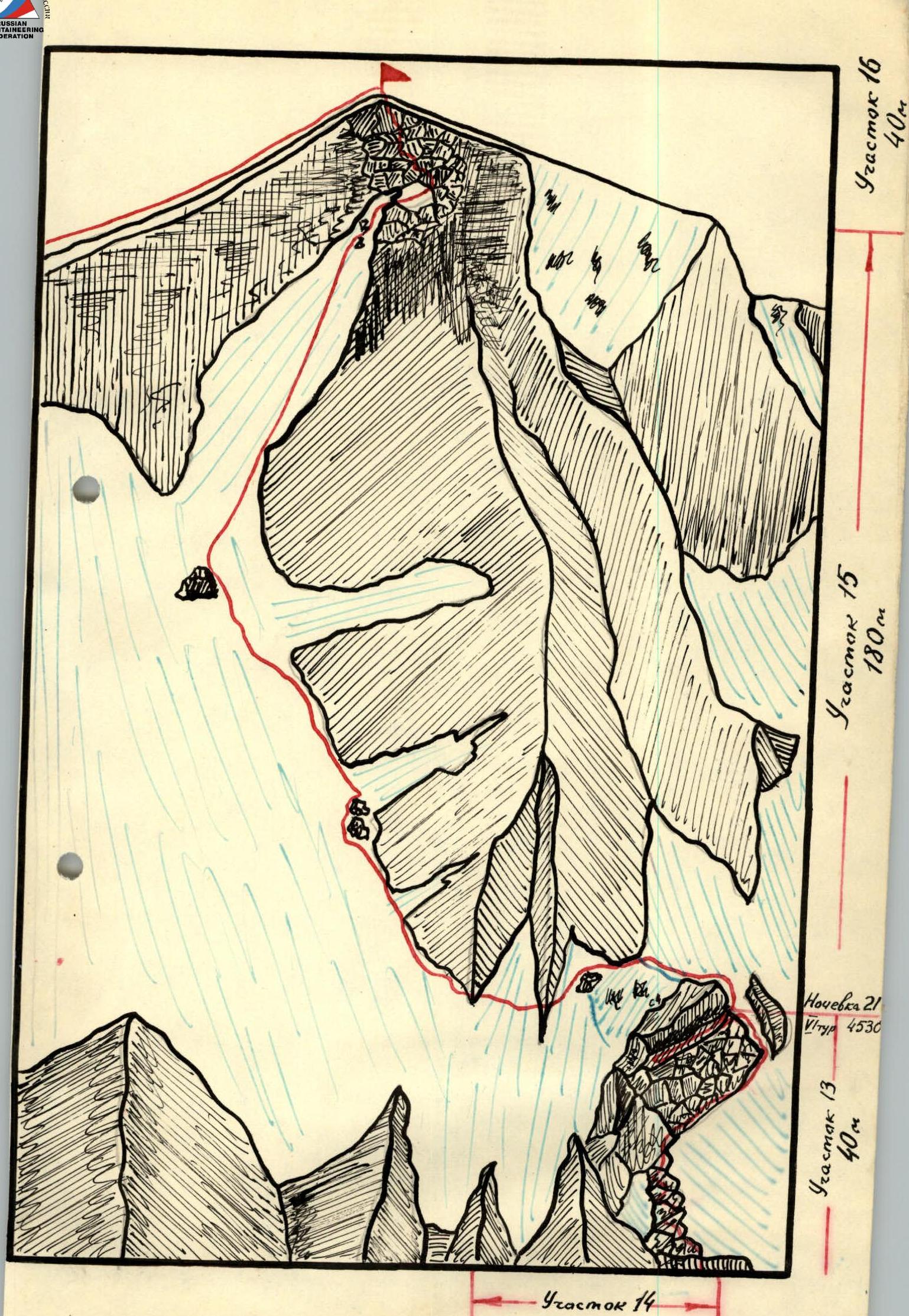
Finally, on August 22, 1953, at 14:17, under the encouraging cries of friends from the storm camp (almost like at a stadium!), the team reached the summit.
Control point. It contains a note from a group of Kazakh State University, who, under the leadership of Master of Sports B. Sh. Mansurov, followed the team of Novosibirsk "Trud" and completed the traverse of the Choktal massif. At 15:00, the descent began.
According to the consultations received (Master of Sports A. P. Kolegova), it was planned to descend along the ridge of the massif to the east to the Choktal pass and from it to the glacier 1st Eastern Dzhindy-Su. However, the sharply deteriorating weather  (fog, visibility 30 m) did not allow us to examine this option, and the group preferred to follow the tracks of the traverse team, leading along a more complex but familiar path, especially since this path was well studied from below during the observation of the wall. As a result, the descent was carried out along the path that begins the traverse of the Choktal massif (route 5B cat. diff.). The section passed on the descent corresponds approximately to route 4B-5A cat. diff. The team had to organize:
- 2 descents "sitting on a rope" of 40 m;
- 6 descents using the "sports method" on steep ice.
Apparently, a simpler descent from the summit to the south along snow-ice slopes and a return to the camp through the Choktal pass is more expedient.
After spending the night on the ridge, the team descended to the storm camp on August 23, 1953, at 13:20. The weather, which had started to deteriorate in the morning (snowfall stopped at night) and continued throughout the day:
- snowfall,
- blizzard,
- visibility 50 m
confirmed the correctness of the decision made - to descend along a familiar path.
6. Team equipment.
During the ascent, we used both standard factory-made mountaineering equipment and "new" (now common) equipment that is still often made " кустарным" (artisanal) way. All homemade equipment intended for load-bearing was tested for strength in the laboratory of the enterprise p/я № 82 (Novosibirsk), and the test protocol is stored in the files of the Novosibirsk regional alpine federation.
From non-standard equipment, the group used:
- 2-step ladders - 6 pcs.
- 5 m ladder - 1 pc.
- platform (according to the sketches of Master of Sports G. Karlov) - 1 pc.
- textolite helmets, construction - 4 pcs.
- pitons - 3 pcs.
- duralumin wedges of 3 types - 20 pcs.
- shлямbur pitons (1 used!) - 45 pcs.
- titanium petal pitons - 10 pcs.
- forehead lamps - 2 pcs.
- "eights" for descent - 4 pcs. (B. Romanova)
- block for transporting rucksacks - 1 pc.
- flare guns - 1 pc. + 4 pcs. in the storm camp
7. Conclusion on the route.
The considered route was initially classified as approximately 5A cat. diff. However, all doubts about this were completely dispelled by reality. No one among those who participated in or observed the ascent doubts that the route is a very strong "five-B". Comparing this route to previously passed routes of a similar type, we can say that it is significantly more complex than the route of Pelevin on Gl. Taldysu and the wall of peak 4600 ("Trud") in Taldysu - both 5B cat. diff.
The route should be recommended for passage by groups of no more than 6 people.
 |
|---|
TABLE OF MAIN CHARACTERISTICS OF THE ROUTE OF ASCENT TO PEAK CHOKTAL (1st Eastern) VIA THE NORTH WALL
Route of ascent: North wall. Height difference of the route: 900 m, including the most complex sections - 300 m. Average steepness of the route: 62°, including the most complex sections - 80-85°.
In the storm camp (day of processing).
| Date | Section | Length by height, steepness (relief) | Characteristics of sections and conditions of their passage (tech. difficulty, method of movement and protection) | Pitons driven (rock, ice, shлямbur) | Time (exit, weather) | Conditions of stop (progress, bivouac) | Weight of daily ration |
|---|---|---|---|---|---|---|---|
| August 15 | R1 | 45 m, 50° (ice slope) | difficult, on crampons with piton protection | rock 2, ice 4, shлямb - | sun 11:00 | 19:00, 8 | 1200 g. |
| R2 | 35 m, 60° (ice couloir) | difficult, on crampons with piton protection | rock 10, ice 1, shлямb - | sun | |||
| R2A | 10 m, 90° ("icicle" - sheer natachenny ice) | very difficult, on crampons, steps, piton protection | rock 5, ice -, shлямb - | sun | |||
| R3 | 20 m, 50° (ice ledge) | medium, on crampons with piton protection | rock 3, ice 2, shлямb - | sun | |||
| August 16 | R4 | 45 m, 50° (3 ice ledges) | difficult, on crampons, steps, piton protection | rock 6, ice 3, shлямb - | sun 10:00 | 19:00, 9 sitting bivouac on "probka" | 1000 g. |
| R5 | 10 m, 90° (rock wall) | very difficult, climbing on ladders with piton protection | rock 5, ice -, shлямb - | thunderstorm, snow | |||
| R5A | 25 m, 70° (rock wall) | difficult, climbing with piton protection | rock -, ice -, shлямb - | clouds | |||
| R6 | 20 m, 80° (slabs with tongues of natachenny ice) | very difficult, climbing on ladders with piton protection | rock 5, ice -, shлямb - | sun | Bivouac on "balcony": 2 in tent and 2 sitting (see p. 7 for details) | 700 g. | |
| August 17 | R6A | 20 m, 90° (crack in internal angle) | very difficult, climbing on ladders with piton protection | rock 7, ice -, shлямb - | thunderstorm, snow | ||
| R7 | 10 m, 50° (ledge with natachenny ice) | difficult, on crampons, steps, piton protection | rock 3, ice 1, shлямb - | clouds 10:00 | 18:00, 8 | ||
| August 18 | R8 | 30 m, 90° (rock internal angle) | very difficult, climbing with piton protection | rock 10, ice -, shлямb - | clouds | ||
| R9 | 30 m, 95° (wall and crack along "red mirror") | very difficult, climbing with platform and ladders and piton protection | rock 15, ice -, shлямb - | sun 10:00 | 18:00-23:00 2 in tent on "balcony" and 2 sitting on ledge above red mirror | 700 g. | |
| August 19 | R9A | 30 m, 90° (sheer smooth wall - top of "red mirror") | very difficult, climbing with platform and ladders and piton protection | rock 15, ice -, shлямb - | thunderstorm, snow | ||
| R10 | 65 m, 80° (rock wall, "black mirror") | very difficult, climbing on ladders with piton protection | rock 17, ice 1, shлямb 1 | thunderstorm 11:00 | 20:00-9:00 2 sitting above red and 2 sitting above black mirrors | 700 g. | |
| August 20 | R11 | 85 m, 45° (ice slope with rock islands) | difficult, on crampons, steps, piton protection | rock 8, ice 7, shлямb - | sun 8:00 | 17:00, 7:00 in tent on ridge | 900 g. |
| August 21 | R12 | 140 m, 60° (two ice couloirs) | difficult, on crampons, steps, piton protection | rock 21, ice 10, shлямb - | sun 10:00 | 18:00, 8:00 on rock ledge, lying one by one | 800 g. |
| R13 | 40 m, 80° (rock crack) | very difficult, climbing with piton protection | rock 9, ice -, shлямb - | sun | |||
| August 22 | R14 | 20 m, 30° (snow-ice ridge with rock outcroppings) | medium, on crampons, piton protection | rock 4, ice -, shлямb - | sun | ||
| R15 | 180 m, 45° (snow-ice slope - "board") | difficult, on crampons, piton protection | rock 12, ice 11, shлямb - | sun 8:00 | 14:17 - on summit! 20:30 - bivouac on ridge (in tent) | 600 g. | |
| R16 | 40 m, 70° (rock wall) | difficult, climbing with piton protection | rock 5, ice -, shлямb - | sun |
Total: 183 rock, 39 ice, 1 shлямbur. Team captain: Meshkov I. N. Team coach: Master of Sports of the USSR Martynov V. A. 4600 g. per person.


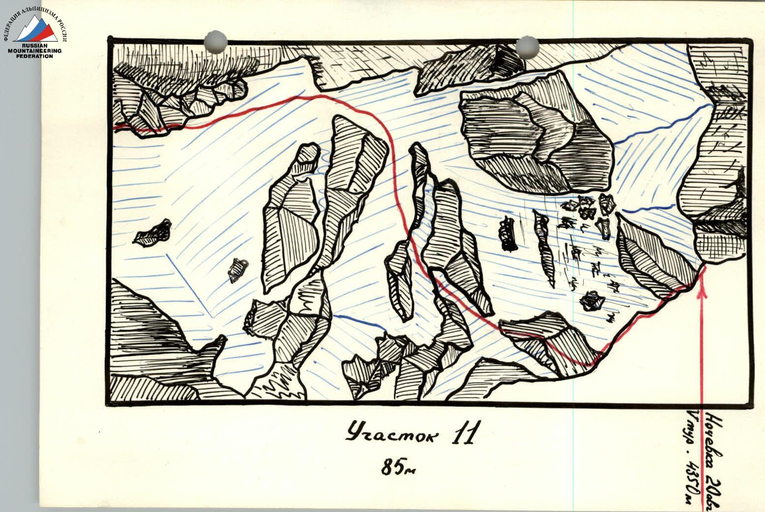
Section R11, 85 m 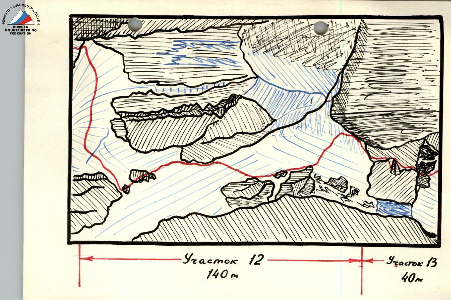
Comments
Sign in to leave a comment