Ascent Passport
- Ascent class — rock climbing.
- Ascent area — Tian Shan, eastern part of Kungey Alatau, Western Cirque of Chon-Uryukty gorge.
- Peak, its height, ascent route — traverse of peaks Sadko-Berendei-Aelita-Chernomor-Kazakhstan (4079 m), category 3A.
- Proposed difficulty category — 5B, combined.
- Route characteristics — height difference — 1200 m, length of sections with 5th category difficulty — 200 m. Average steepness —
- 37 rock anchors were hammered for belaying and 2 chocks were used.
- Number of climbing hours — 19 hours.
- Number of nights and their characteristics — one night on peak Aelita on a constructed comfortable platform, lying down.
- Surname, name, patronymic of the team leader, participants and their qualifications:
- Krasnoukhov Yuri Vasilyevich — Master of Sports — team leader
- Vorobyov Arkady Nikolaevich — 1st sports category
- Lopatko Alexey Dmitrievich — 1st sports category
- Sagananenko Galina Iosifovna — Candidate for Master of Sports
- Terekhov Alexander Nikolaevich — 1st sports category
- Yamaev Vitaly Alekseevich — 1st sports category
- Team coach — Krasnoukhov Yu.V.
- Date of departure and return: August 10 — August 11. Approach to the route — August 9.
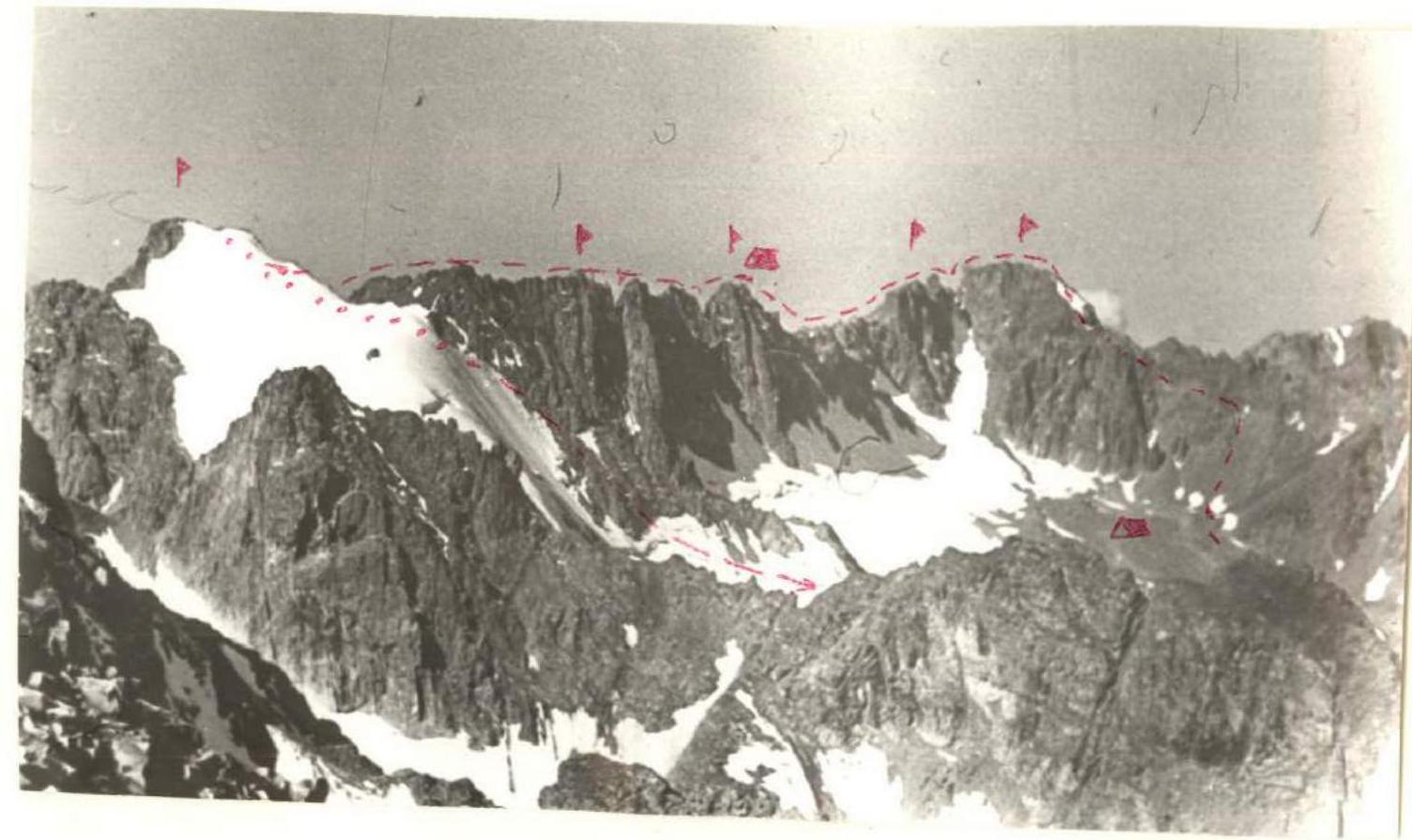


Map of the traverse area (Chon-Uryukty gorge, North slopes of Kungey Alatau, Tian Shan)
Brief description of approaches to the route.
Peaks Sadko — Kazakhstan (4079 m) are located in the eastern part of Kungey Alatau range (Tian Shan) in the upper reaches of Chon-Uryukty gorge. A spur of the range with peaks Asol and Suvenir divides the gorge into Eastern and Western cirques. The Chon-Uryukty base camp is located at the confluence of rivers flowing from the Eastern and Western cirques and forming the Chon-Uryukty river. Overcoming three stages of moraine scree, we enter the Western cirque of the glacier flowing from the slopes of peak Kazakhstan — Sadko.
Preparation for the Ascent
The team conducted preparation for the ascent during the entire preparatory period. The program of general physical training included: — regular training; — long-distance cross-country skiing. Special training included rock climbing training. Before the traverse, the group made three ascents of a wall character. During these ascents, the route of the proposed traverse was observed.
Tactical Plan of the Traverse
Day 1. Departure from Chon-Uryukty base camp, approach to the route in the Western cirque, overnight stay. Day 2. Start of the traverse with an overnight stay, partial completion of the route, overnight stay in the area of peaks Aelita — Chernomor. Day 3. Completion of the traverse, descent into the Western cirque and then to the base camp. Backup option: 3rd overnight stay in the Western cirque.
Table of main route characteristics
| Date | Designation | Average steepness in degrees | Length in m | Relief character | Difficulty | Condition | Weather conditions | Rock anchors | Ice anchors | Pits | Notes |
|---|---|---|---|---|---|---|---|---|---|---|---|
| 1 | 2 | 3 | 4 | 5 | 6 | 7 | 8 | 9 | 10 | 11 | 12 |
| 10.08.1981 7:00 | 0–1 | 40° | 500 | Narrow rock shelf, scree shelf, rock ridge | 2 | Wet ground on shelf, snowy rocks, "live" stones | Clear | - | - | - | Ascent to peak Sadko |
| 8:40 | 1–2 | 20° | 200 | Scree ridge | 1 | Snowy scree | Clear | - | - | - | |
| 8:50 | 2–3 | 85° | 35 | Destroyed rock wall, col | 5 | Snowy destroyed rocks | Variable cloudiness | 2 | - | - | Diagonal descent on a rope |
| 9:10 | 3–4 | 50° | 5 | Rock wall | 3 | Wet rocks | Wind | - | - | - | |
| 9:20 | 4–5 | 45° | 150 | Destroyed sharp ridge with small gendarmes | 3 | Wet destroyed rocks | Wind | - | - | - | Exit to the col |
| 1 | 2 | 3 | 4 | 5 | 6 | 7 | 8 | 9 | 10 | 11 | 12 |
| --- | --- | --- | --- | --- | --- | --- | --- | --- | --- | --- | --- |
| 10:00 | 5–6 | 80° | 45 | Narrow steep rock shelf on the left wall of the ridge | 4 | Wet rocks | Cloudy | 4 | - | - | Gendarm |
| 10:30 | 6–7 | 70° | 40 | Wall, col | 4 | Wet rocks | Cloudy | 1 | - | - | Descent on a rope |
| 11:00 | 7–8 | 80° | 40 | Wall | 4 | Wet rocks | Snow crust | 2 | - | - | Peak Berendei |
| 11:40 | 8–9 | 20° | 60 | Rock ridge | 2 | Destroyed rocks, stones | Snow | - | - | - | |
| 12:00 | 9–10 | 80° | 70 | Rock wall, descent to a sharp ridge | 5 | Snowy rocks, expected destruction | Snow | 3 | - | - | Descent on a rope with re-clipping |
| 12:40 | 10–11 | 30° | 120 | Sharp jagged ridge formed by slabs | 3 | Snowy rocks | Snow | 3 | - | - | |
| 13:00 | 11–12 | 70° | 70 | Steep rock ridge, then rock wall before scree col | 4 | Destroyed, snowy rocks | Snow | 1 | - | - | Descent 30 m by climbing, 40 m — on a rope |
| 1 | 2 | 3 | 4 | 5 | 6 | 7 | 8 | 9 | 10 | 11 | 12 |
| --- | --- | --- | --- | --- | --- | --- | --- | --- | --- | --- | --- |
| 14:00 | Scree col | Thunderstorm, hail | - | - | - | Group waited out the storm | |||||
| 15:00 | 12–13 | 60° | 120 | Destroyed rock ridge with gendarmes | 4 | Snowy rocks | Clear | - | - | - | Descent from gendarm on a rope |
| 15:30 | 13–14 | 70° | 80 | Destroyed rock wall, ridge of gendarm with two peaks | 3 | Same | Clear | - | - | - | Gendarm with two peaks |
| 15:50 | 14–15 | -10° | 35 | Negative wall, then narrow sharp col before ridge of peak Aelita | 5 | Same | Clear | 2 | - | - | Diagonal descent on a rope |
| 16:00 | 15–16 | 70° | 40 | Destroyed rock wall | 4A | Wet rocks | Clear | 2 | - | - | Exit to the shoulder of the ridge |
| 17:00 | 16–17 | 20° | 40 | Destroyed rock ridge, bypassing rock fins | 4 | Wet rocks | Clear | - | - | - | |
| 17:30 | 17–18 | 70° | 50 | Series of rock sheer walls 3–5 m, monolithic blocks | 4 | Wet rocks | Clear | 2 | - | - | Exit to the summit ridge |
| 1 | 2 | 3 | 4 | 5 | 6 | 6 | 7 | 8 | 9 | 10 | 11 |
| --- | --- | --- | --- | --- | --- | --- | --- | --- | --- | --- | --- |
| 18:00 | 18–19 | 30° | 120 | Destroyed gentle ridge, slabs, blocks | 3 | Powerful rocks | - | - | - | - | Peak Aelita |
| 19:00 | - | - | - | Comfortable platform for overnight stay under a large stone, made by the group on peak Aelita | - | - | - | - | - | - | Overnight stay |
| 11.08.1981 19:00–20:00 | 19–20 | 60° | 20 | Destroyed rock ridge (descent) | 3 | Destroyed rocks | Clear | 2 | - | - | Descent by climbing |
| 7:20 | 20–21 | 80° | 40 | Wall, narrow sharp col with destroyed "finger" | 5 | Wet rocks | Clear | 2 | - | - | Diagonal descent on a rope |
| 8:00 | 21–22 | 80° | 60 | Destroyed rock wall (left side of the ridge) | 4 | Wet rocks | Clear | 3 | - | - | Exit to the ridge of peak Aelita I East |
| 9:00 | 22–23 | 20° | 60 | Destroyed ridge of large blocks | 3 | "Live" stones | Clear | - | - | - | Peak Aelita I East |
| 9:30 | 23–24 | 65° | 60 | Destroyed rock wall of the ridge, col | 4 | Same | Same | 2 | - | - | Descent by climbing 20 m, 40 m on a rope |
| 1 | 2 | 3 | 4 | 5 | 6 | 7 | 8 | 9 | 10 | 11 | 12 |
| --- | --- | --- | --- | --- | --- | --- | --- | --- | --- | --- | --- |
| 10:00 | 24–25 | 60° | 60 | Destroyed rock ridge with gendarmes, bypass on the right | 3 | Destroyed wet rocks | Clear | - | - | - | Peak Aelita II East (Chernomor II) |
| 10:45 | 25–26 | 60° | 60 | Rock couloir exiting to scree col | 2 | Same | Same | - | - | - | Descent to the col |
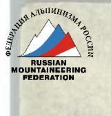
| 11:15 | 26–27 | 90° | 80 | Rock wall with overhanging sections before the ridge of peak Chernomor | 5 | Same | Same | 6 | - | - | Key section of the route |
| 12:00 | 27–28 | 55° | 40 | Rock destroyed ridge | 3 | "Live" stones | Cloudy | - | - | - | Exit to peak Chernomor |
| 12:00 | 28–29 | 45° | 400 | Ridge with small gendarmes and cols (ascent to East peak Chernomor via rock chimney 10 m) | 3 | Destroyed rocks with snow | Thunderstorm, snow | - | - | - | On peak Chernomor — triangulation sign |
| 12:40 | 29–30 | 45° | 200 | Scree ridge | 2 | Snow on rocks, slippery | Same | - | - | - | |
| 13:10 | 30–31 | 30° | 500 | Gentle snowy ridge with a rise | 2 | Wet snow | Snowfall | - | - | - | Exit to peak Kazakhstan |
| 1 | 2 | 3 | 4 | 5 | 6 | 7 | 8 | 9 | 10 | 11 | 12 |
| --- | --- | --- | --- | --- | --- | --- | --- | --- | --- | --- | --- |
| 13:40 | 31–32 | 50° | 200 | Scree shelves, snow-rock destroyed ridge (ascent to peak Kazakhstan) | 3 | Snowy rocks | Snow | - | - | - | Peak Kazakhstan |
| 14:25 | 31–32 | 50° | 200 | Same | 3 | Same | Snow | - | - | - | Descent back to the ridge of peak Kazakhstan |
| 14:20 | 32–33 | 45° | 400 | Snow-ice North slope of the ridge of peak Kazakhstan — peak Chernomor, bergschrund, then closed glacier with crevasses | 2 | Wet snow 30 cm on ice, then deep firn | Snow | - | - | - | Descent with belaying through ice screws and ice axe |
Total: climbing hours — 19, 37 rock anchors hammered, 2 chocks used 
Brief Explanations
to the table of main characteristics of the traverse route of peaks Sadko-Berendei-Aelita-Chernomor-Kazakhstan, category 5B, approximately.
Approach to the start of the route. Along the trail and moraine scree from Chon-Uryukty base camp to the glacier of the Western cirque of Chon-Uryukty gorge. Along the upper part of the glacier, then along the scree slope — ascent to the lowest col of the ridge between peaks Sadko and Ikar.
Section R0–R1. 100 m before the col — left to a narrow long red shelf bypassing three gendarmes of the ridge and exit to the ridge along it. The next rock ascent of the ridge is bypassed on the right and ascent along the snowy rock ridge (cautious, stones!) to peak Sadko. Control cairn.
R1–R2. Along the stable scree ridge of the peak to the col before the ridge on peak Berendei (formerly Bezymyanaya).
R2–R3. Diagonal descent to the left on a rope along a destroyed steep wall to the col (a large snowy couloir from the Western cirque ascends here).
R3–R4. From the col along a rock wall 5 m — cross the ridge — the beginning of a lateral spur going towards Issyk-Kul.
R4–R5. Along the destroyed sharp ridge with small gendarmes (passed head-on) — exit to the col before the Big Gendarm of peak Berendei.
R5–R6. Ascent to the saddle of the Big Gendarm's peak on the left side of the ridge along a narrow steep rock shelf, then along the wall. Careful anchor belaying. Control cairn.
R6–R7. Descent on a rope to the col.
R7–R8. Complex ascent along the wall of the ridge 40 m to peak Berendei. Control cairn.
R8–R9. The ridge of the peak — a jumble of slabs and rock blocks.
R9–R10. Descent along the wall 70 m with re-clipping to a sharp col formed by two inclined slabs. Careful anchor belaying.
R10–R11. Further — a jagged sharp ridge formed by slabs, 3 ropes (anchor belaying).
R11–R12. Descent along the ridge by climbing 30 m, and then — 40 m on a rope along the wall to a scree col before the next gendarm.
R12–R13. From the col (after waiting out the storm) — a simple destroyed ridge with gendarmes, descent from which — 40 m on a rope. On the gendarm's peak — control cairn.
R13–R14. Further — ascent to a large gendarm with two peaks. Control cairn. On the gendarm's ridge — horizontal running belay.
R14–R15. Complex diagonal descent 40 m on a rope along an overhanging wall to a narrow sharp col before the ridge of peak Aelita.
R15–R16. From the col — ascent along steep destroyed rocks of the ridge 40 m to rock fins. Complex bypass on the left. Shoulder of the ridge.
R16–R17. Along a gentle destroyed ridge — approach to the next ascent of the ridge.
R17–R18. Complex climbing along a series of 3 and 5-meter vertical walls formed by monolithic blocks. Exit to the ridge of the peak.
R18–R19. Destroyed gentle ridge formed by blocks and slabs. Ascent to peak Aelita along it. Control cairn. On peak Aelita, the group organized an overnight stay on a constructed comfortable platform among large stones. On the north side of the peak, there is snow.
R19–R20. From the peak — descent first 20 m by climbing. R20–R21. Then on a rope 40 m — diagonal descent to a narrow destroyed col with a pillar in the middle ("live" stones!).
R21–R22. From the col — complex ascent along the left wall of the ridge 60 m to the ridge of peak Aelita I East.
R22–R23. Along the ridge (destroyed rocks, slabs) 60 m. On the peak — control cairn.
R23–R24. Descent 60 m (40 m on a rope) to the next col before the ascent of the ridge of peak Aelita II East.
R24–R25. From the scree col — ascent along a simple destroyed ridge with a bypass of a small gendarm on the right along the way to peak Aelita II East. Control cairn.
R25–R26. Along a simple rock couloir — descent to the col before the wall of peak Chernomor.
R26–R27. Key location of the route — wall 80 m of the ridge of peak Chernomor. Ascent along the wall: — First 30 m to the right of the col with exit to the left to an inclined shelf. — From the shelf 20 m along a sheer rock wall, with overhanging sections up to 2–2.5 m, to a scree shelf ("live" stones!). — Further 30 m along steep, местами нависающим скалам — выход на простой гребень вершины.
R27–R28. Along the ridge — ascent 40 m to peak Chernomor. Control cairn.
R28–R29. Along the strongly destroyed ridge of peak Chernomor with a series of small gendarmes and cols to the eastern peak of the massif, where the triangulation sign is located. Ascent to the East peak along a destroyed rock chimney 10 m.
R29–R30. Descent from the Chernomor massif along the scree ridge leading to peak Kazakhstan.
R30–R31. Snowy gentle ridge with a series of ascents. Along it — to the rock tower of peak Kazakhstan.
R31–R32. Ascent to it along scree shelves with exit to the South ridge of the peak (on route 3A category). Control cairn. Descent from the peak along the ascent route, back to the snowy gentle ridge between peaks Kazakhstan and Chernomor.
R32–R33. Descent along the ice-snow slopes of the ridge to the glacier of the Western cirque. Careful belaying through ice screws and ice axe on steep sections of the slope, as well as when crossing the bergschrund and snow bridges over crevasses of the glacier.
Comments on the entire route:
- The route is extremely prone to rockfall.
- Time taken to complete the route without stops for rest and overnight stay — 20 hours.
- Possible overnight stays — on main peaks and peaks of large gendarmes in the absence of thunderstorm danger, as well as on some scree cols of the ridge.
Communication
Communication was carried out with the "Lokomotiv" group via "Vitalia" radio station at even hours. The group also had flares.
SADKO

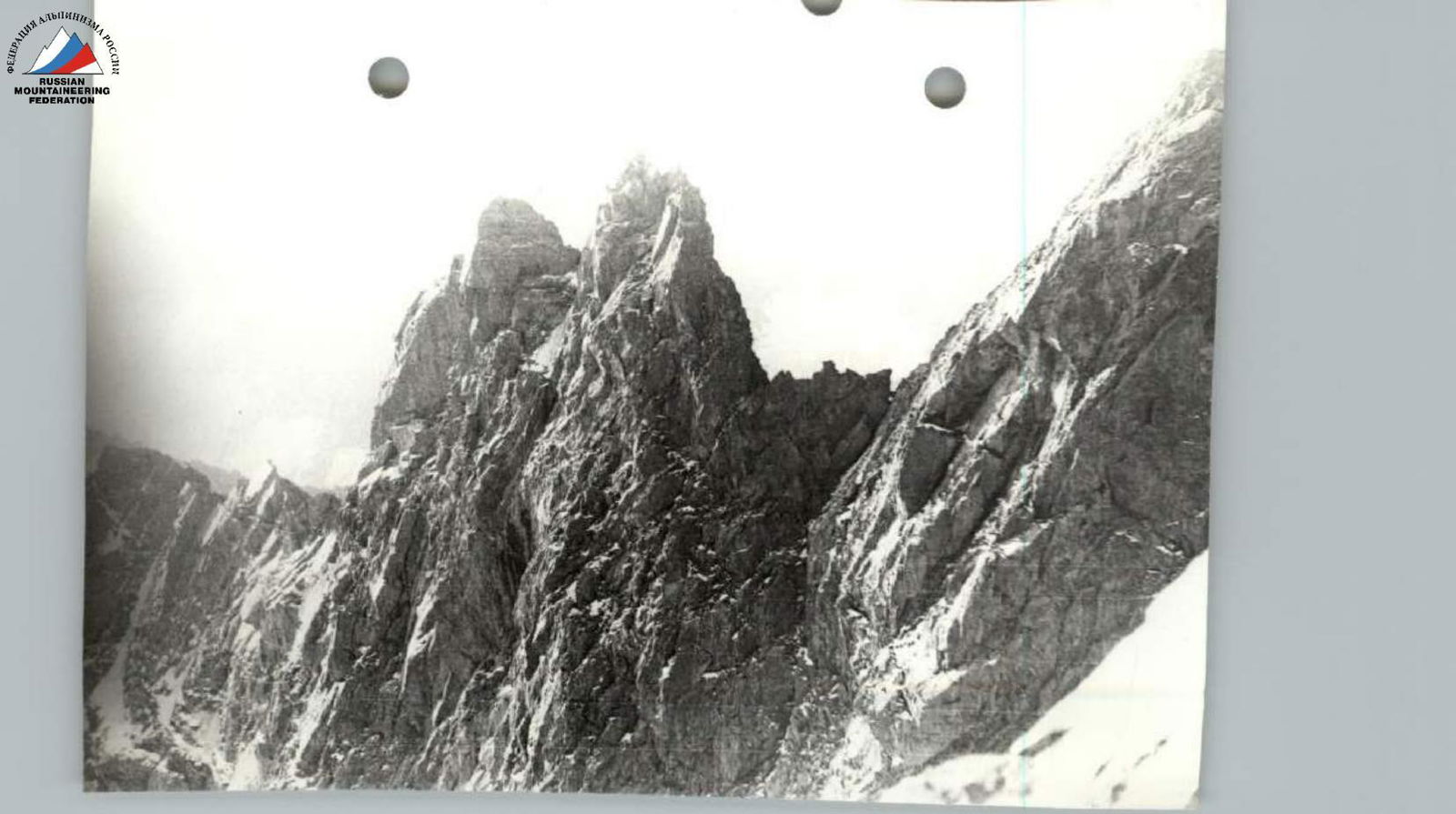
Narrow rock shelf leading to the col Sadko–Ikar. Section R0–R1.
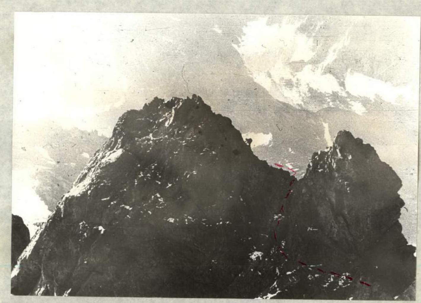
Big gendarm before peak Bezymanaya (Berendei).
Wall on peak Chernomor. Key section. Section R26–R27.