
REPORT on the First Ascent of the North Face (Center) of Dure Peak
HISTORICAL AND GEOGRAPHICAL OVERVIEW OF THE REGION
Dure Peak is located in the western part of the Kungey-Alatau ridge, which borders the Issyk-Kul lake depression from the north, starting from the Boemskoe gorge in the west and stretching in a nearly latitudinal direction. The ridge is approximately 275 km long and 31 km wide in its highest part. The ridge consists of two parts - eastern and western. Spurs extend from the Kungey-Alatau watershed ridge, mainly in the northern and southern directions, dividing the lateral river valleys. The most significant lateral spurs by height are:
- Chontal,
- Orto-Koisu,
- Karakorum, etc.
Dure Peak is adjacent to the 1st western peak of the Chontal massif. The height of Dure Peak, according to the 1962 survey, is 4538 m.
The first sufficiently detailed map of the Kungey-Alatau ridge was compiled by V. Gorbunov in 1937.
In the same year, A. Ignatiev conquered the highest point of the ridge - Chontal, 4771 m high.
In subsequent years, several ascents were made in the Chontal massif area, up to category 5B difficulty.
Dure Peak has relatively simple ascent routes from the south, which are not of interest from an alpinism point of view. However, to the north, the peak drops with interesting steep walls of great length.
Despite this, until now, the peak has not been the object of alpinist activities from the north, apparently due to:
- more difficult approaches compared to the Chontal massif;
- less studied.
The geological nature of Kungey-Alatau consists of Paleozoic sedimentary rocks: shales, sandstones, and limestones, interrupted by intrusions of igneous rocks - granites and diorites. In particular, the north face of Dure is composed of the latter.
The weather in the specified area is variable, characteristic of the northern Tien Shan. In the first half of summer, the weather is usually unstable, settling by the end of August, with sunny days and minor precipitation. The warmest month is July. In the summer period, in the high-altitude zone, mountain-valley winds are well expressed. The wind speed is low and maximum during the day - in the night and morning hours.
ROUTE RECONNAISSANCE, DEVELOPMENT OF THE ASCENT TACTICAL PLAN
Even during the 1966 expedition of the "Enbek" sports society, which aimed to traverse the Chontal massif from east to west, the auxiliary group, being in the Dure pass area, paid attention to the north steep wall of Dure Peak.
On the advice of a member of this group, Vardanov Z., we undertook reconnaissance to determine the possibility of an ascent from this side.
The north face of Dure is divided by steep, wide ice couloirs into three parts. For our group's ascent, the middle part of the wall was chosen, leading directly to the summit, as the most logical.
Long-term observations of the wall showed that the ice couloirs are exposed to rockfall during the day, making them objectively dangerous. The crown of the summit is edged with ice-snow cornices directed north, except for one short section on the left side. It was on this section that the exit from the route to the summit was planned. Due to the north orientation of the wall and the proximity of the Chontal massif from the east, the wall is practically not lit by the sun throughout the day. Inspection of the wall from the side showed that the overall steepness of the wall is 65-70°, and the wall has a stepped structure, where extended steep sections alternate with narrow, typically inclined ledges. The inspection also revealed the presence of ice sections on the wall.
A review of the wall from different points and distances allowed for a detailed planning of the upcoming ascent route. The ascent confirmed the correctness of the chosen route; there were practically no deviations. The overnight stay under the route on the right lateral moraine - 3570 m (according to the altimeter).
During the reconnaissance, two possible descent paths were identified:
- along the ridge to the west, and then along the counterfort to the north and overnight stay under the route on the right lateral moraine;
- to the south with a subsequent exit to the Dure pass, and from it - to the same overnight stay.
Based on the reconnaissance results, the following tactical ascent plan was developed:
- A group of 4 people will attempt to climb the summit.
- The estimated time to complete the route is 4 days.
- The lower part of the route, representing an ice slope, is preliminarily processed by a "pair" of climbers.
- Due to the presence of ice sections on the route, the group takes one pair of crampons, one ice axe, and one ice pick for the ascent.
- Due to the danger of rockfall, the group starts the route no later than 7:00.
SAFETY MEASURES. COMMUNICATION
The organization of the ascent was based on compliance with all necessary safety measures. Namely:
- Group members, before starting the specified route, completed several joint ascents, including category 5B difficulty.
- The ascent to the summit was carried out simultaneously by two groups along parallel routes with close interaction (the group led by O. Posmachev ascended along the left part of the wall).
- Under the route, there was a group of observers who maintained regular communication with the participants of the assault group and the base camp.
- A doctor and a car were constantly available at the base camp.
- The group was provided with a medical kit and was thoroughly instructed by the camp doctor on first aid.
Communication was carried out as follows:
- Between the assault group and observers - by flares.
- Between observers and the base camp - by radio.
The observers had an R-127 radio station, and the base camp had an R-104. (The order and time of communication are specified in the route sheet).
COMPOSITION OF THE ASSAULT GROUP
| 1. POPENKO Yu.S. | leader | Master of Sports Candidate |
|---|---|---|
| 2. BELOVOL E.V. | participant | Master of Sports Candidate |
| 3. ILINSKY A.F. | participant | Master of Sports Candidate |
| 4. POLNOV V.G. | participant | 1st category sports rank |
All team members know each other well and have repeatedly undertaken joint ascents, including during this sports season. Three participants have won prizes at the Kazakh SSR championships.
DESCRIPTION OF THE ASCENT ROUTE
August 13 Having left the base camp located in the Chop-Kemin river valley at an altitude of 2200 m, at 10:00, the assault group, along with observers Lebedinsky L. and Kolokolnikov A., approached the north face of Dure Peak at 16:00 and set up camp on the right lateral moraine of the glacier. The rest of the day was used to observe the wall to supplement the data from the reconnaissance conducted on August 10-11.
August 14 Taking into account the danger of rockfall during the day in the lower part of the route, a pair of climbers started processing the ascent path at 6:00 (Polnov V. and Ilinsky A.). Having crossed the glacier separating the wall from the camp, they approached the beginning of the route. The start of the route is an ice slope with a steepness of up to 45°, increasing in the bergschrund, with a length of 160-200 m.
This section was traversed with step cutting. Then followed the overcoming of the bergschrund along an ice wall 2 m high and an ice slope with a steepness of 60°, 40 m long. This section was traversed with step cutting, on crampons with insurance through ice and rock hooks. The rock island represents rocks of medium difficulty with a tile-like structure. Numerous holds are covered with snow, and in some places, with rimaye ice. The length of the rock island is one rope, 40 m, and the overall steepness is 60°. It took 5 hours to process the beginning of the route. After that, the pair descended, leaving a 2-rope belay. The descent to the camp took about 1 hour and 30 minutes. The early descent was dictated by safety considerations.
August 15 The group started the route at 7:00. Having passed the processed section, the group approached the second ice slope, which separates the rock island from the main wall massif. The first to ascend this day with a lightened backpack was Polnov V. From the upper end of the rock island, along this ice slope with a steepness of 60° and a length of 20 m, the movement goes up-right with step cutting to the beginning of the main rock massif, and then along heavily destroyed rocks of medium difficulty, with a steepness of 60° and a length of 20 m, similar in structure to the island rocks, up-left to the beginning of a large inclined ledge. The inclined ledge, 2-3 m wide, is covered with rimaye ice on the left side. Traversing the ledge to the left for 30 m, followed by an ascent of 10 m along an ice slope with a steepness of 50° with step cutting, leads to difficult rocks. The ascent along rocks with a steepness of 60-65° and a length of 15 m, covered with rimaye ice, goes from the left side of the rock massif, and then along a 15-meter vertical wall, which leads to a groove 15 m long, filled with ice. The groove, in turn, leads to a horizontal ledge suitable for an overnight stay. On the ledge, there is a short traverse to the right (3 m) under a narrow chimney 7 m high and 0.5 m wide. The ascent through the chimney with difficult climbing and subsequent pulling up of backpacks ends on an inclined platform, which is traversed to the left under a steep wall about 25 m high with good holds. Above the wall is a narrow shelf. From the shelf, the movement is to the left (2 m) under a 3-meter vertical wall, transitioning into an internal corner. The wall is passed with the help of a ladder. Up the corner, along rocks of above-average difficulty, under a 20-meter wall, which is overcome "en face" along easy rocks of a stepped profile. The wall ends on an inclined talus platform, where the first overnight stay was organized. A first control cairn was also built on this platform. The time of stopping for the night was 16:30. The remainder of the daylight until 19:00 was used by the pair consisting of Polnov and Ilinsky to process the route further, hanging two ropes from the chosen overnight stay location.
August 16 The movement begins by going up 5 m and ascending a 15-meter wall with difficult rocks due to the limited number of holds. Steepness is 75-80°. The wall transitions into an internal corner 20 m long and 65° steep, with a tile-like structure of rocks and small overhanging rock cornices. The corner was traversed using ladders. At this section, backpacks were pulled up. At the top, the corner ends on a narrow, short rock shelf. From it, the further path lies along a steep 4-meter wall, not having cracks for hooks, up under a 35-meter wall of stepped structure, 50° steep. Overcoming this wall is not difficult. Short vertical walls forming it alternate with ledges convenient for belaying. The 35-meter wall leads to the ridge of the massif. It should be noted that until the ridge, the movement was mainly along the left side of the rock massif. A section of the ridge with easy rocks, 25 m long and 50° steep, is simple only until a 15-meter groove 60° steep. Passing through the groove is quite complex as it is filled with rimaye ice. After the groove, there is a 10-meter traverse to the left along an ice slope with embedded stones, 60° steep, leading to a narrow, inclined ledge 0.5 m wide and 15 m long. The ledge is traversed to the left, ending in a vertical 30-meter wall with difficult rocks due to the small number of holds and cracks for hook belaying. The first 15 m of the wall are passed straight up. The second 15-meter section is traversed up-left, exiting into an internal corner filled with rimaye ice, 50° steep and 40 m long. The internal corner again leads to the ridge of the massif. Here, there is a convenient place for an overnight stay. When moving along the ridge, two 2-meter steep walls with smooth surfaces are overcome by "laddering". They are followed by ice-filled slabs 40° steep and 15 m long. Traversing them to the right, we exit under a 10-meter wall with rocks of medium difficulty and good holds. Along this wall, along the boundary of rocks and ice, the ascent continues with step cutting. The steepness of the ascent is 60°, and the length is one rope, 40 m. This path leads to the beginning of a ridge, along which the only path to the pre-summit rock massif lies. The first section of the ice ridge, 20 m long, has a steepness of 20°, is traversed with step cutting on crampons, and ends in a large rock outcrop. From the rock outcrop, the movement continues along the continuation of the ice ridge, 45 m long and up to 65° steep, also with step cutting and on crampons. The ridge abuts against a steep rock wall of the pre-summit rock massif. Further movement is up-right along a 35-meter wall 50° steep, with heavily destroyed rocks and an internal corner. Climbing is of medium difficulty. Then, the movement is up along a vertical internal corner, 10 m, under a rock cornice. Under the cornice, there is a traverse to the right onto a wall, exiting onto the cornice. Climbing is very difficult, with the use of ladders. Further, up-right along a crevice (8 m) onto a smooth slab 30° steep and 5 m long, under a negative internal corner with a pit in the upper part. The corner is overcome with very difficult climbing, using ladders. From the top of the internal corner, there is a traverse to the left (5 m) along an inclined ledge under overhanging rocks - by crawling, exiting onto smooth rocks like "sheep's foreheads" 50° steep, covered with rimaye ice. The ascent along the slabs up (12 m) is where a sitting overnight stay is organized. Starting from the internal corner (from its base) - backpacks are pulled up. The overnight stay was set up at 21:00.
August 17 The ascent began at 4:30. The exit to the route was at 6:00. The first to ascend was Popenko Yu. Along smooth rocks up from the bivouac site, the ascent (10 m) is to the lower boundary of an ice slope 50° steep. The ice slope has a large extent, increasing in steepness in the upper part, and leads under steep monolithic rock walls, above which snow-ice cornices are visible on the ridge. Along the lower boundary of the ice slope (30 m) above the rock cliffs, the movement is to the left along ice on crampons with step cutting. Step cutting and passage of this section are complicated due to the fact that the base of the lower part of the ice slope is formed by smooth slabs of the same steepness. Here, there is a place for an overnight stay for 4 people. Further, the ascent is up (30 m) along a wide ice groove 65° steep, increasing in the upper part to 80°, with protruding single stones. The ascent is on crampons with step cutting. The groove abuts against steep rock walls. Under them, there is a traverse (10 m) to the left - up along the boundary of ice and overhanging, heavily destroyed rocks, exiting onto a platform of the pre-summit ridge. Some sections of the traverse are overcome by crawling. From the platform, the ascent is up (8 m) along a steep wall, negative in the lower part, with the help of ladders, transitioning to the right into a crevice 80° steep, and an ascent along it for 4 m, onto a steeply inclined small ledge covered with ice. Climbing is complex. From the ledge, the ascent continues with difficult climbing up along a steep wall - 5 m, which then becomes less steep, up to 70°, representing rocks of medium difficulty, 25 m long. The wall ends on a horizontal ledge 1 m wide. In the lower part of the wall, on a 20-meter section - backpacks are pulled up. From the ledge, along rocks of medium difficulty, 70° steep, 40 m long, the exit is onto the summit in a break in the ice cornice. The time of reaching the summit was 15:00.
The descent from the summit to the south was along an ice slope, transitioning into a talus. Further, there was an ascent to the Dure pass from the south and a return to the camp on the moraine under the beginning of the route. The descent took 5 hours.
TABLE OF MAIN CHARACTERISTICS OF THE ASCENT ROUTE
Ascent route - North face of Dure Peak, center Height difference during ascent - 968 m Height of Dure Peak - 4538 m Height of camp under the wall - 3570 m Length of the most complex sections of the route - 205 m Backpack pulling - 920 m Number of working hours on the route, including descent - 47 hours.
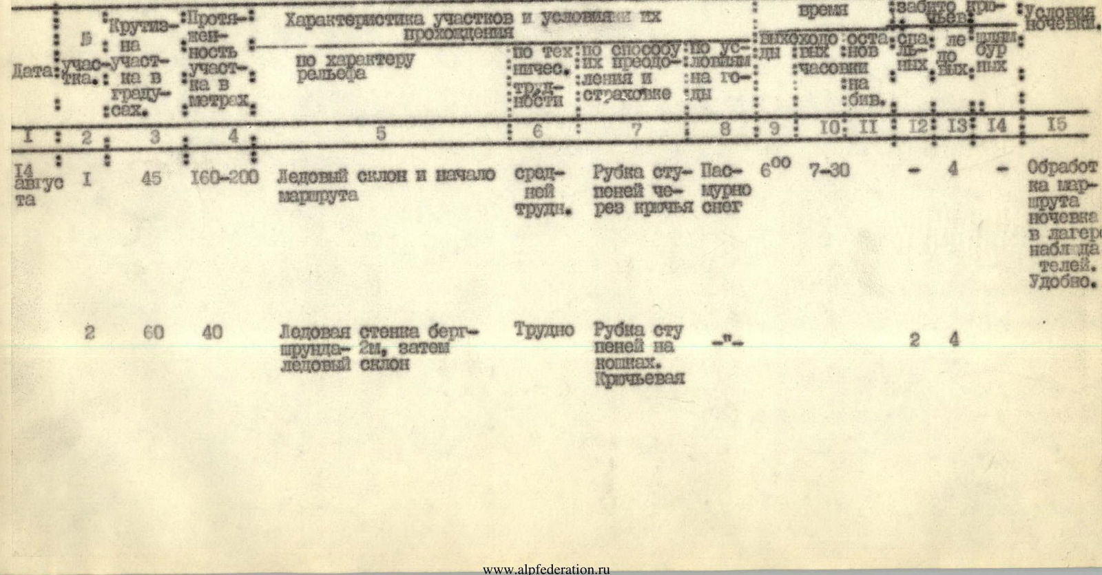
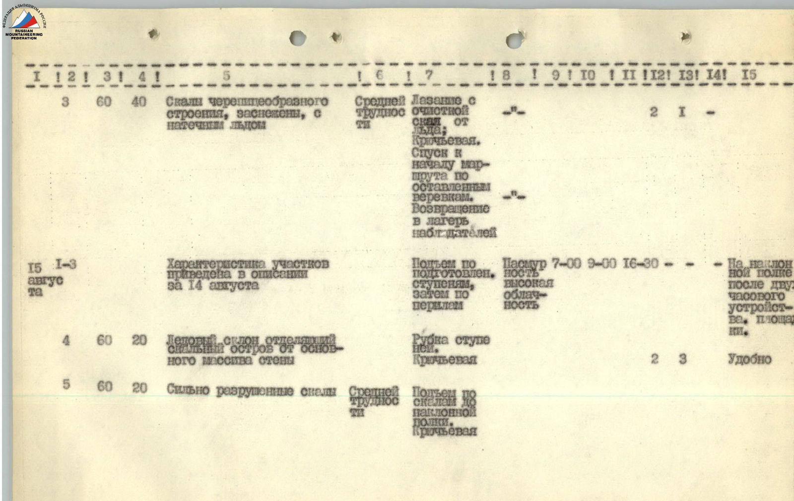
TABLE OF MAIN CHARACTERISTICS OF THE ASCENT ROUTE ON DURE PEAK, NORTH FACE, CENTER
(by sections)
| № | Date | Steepness of section in degrees | Length of section in meters | Characteristics of sections and conditions of their passage by relief character | Technical overcoming and belaying | Conditions on mountain/bivouac | Time (hours) | Driven hooks, pcs. | Used perils, m | Number of overnight stays | General bivouac conditions |
|---|---|---|---|---|---|---|---|---|---|---|---|
| 1 | Aug 14 | 45 | 160–200 | Ice slope and beginning of route | Medium difficulty. Step cutting through hooks, snow. | Cloudy | 6:00–7:30 | 4 | Route processing, overnight stay in observers' camp. Comfortable. | ||
| 2 | 60 | 40 | Ice wall of bergschrund 2 m, then ice slope | Difficult. Step cutting on crampons. Hook belaying. | 2 | 4 |
| № | Date | Steepness of section in degrees | Length of section in meters | Characteristics of sections and conditions of their passage by relief character | Technical overcoming and belaying | Conditions on mountain/bivouac | Time (hours) | Driven hooks, pcs. | Used perils, m | Number of overnight stays | General bivouac conditions |
|---|---|---|---|---|---|---|---|---|---|---|---|
| 3 | Aug 15 | 60 | 40 | Rocks with tile-like structure, snow-covered, with rimaye ice | Medium difficulty. Climbing with clearing equipment from ice. Hook belaying. | Cloudy, high clouds. | 7:00–9:00, 16:30 | 2 | 1 | On inclined ledge after two hours of arrangement, platform. | |
| 4 | 60 | 20 | Ice slope separating rock island from main wall massif | Step cutting. Hook belaying. Ascent along prepared steps, then along perils. | Comfortable. | 2 | 3 | ||||
| 5 | 60 | 20 | Heavily destroyed rocks | Medium difficulty. Ascent along rocks to inclined ledge. Hook belaying. | |||||||
| 6 | Inclined ledge 2–3 m wide, covered with rimaye ice on left side | Traverse of ledge to left for 30 m. Hook belaying. | 2 | 3 | |||||||
| 7 | 50 | 10 | Ice slope | Step cutting. Hook belaying. | 2 | ||||||
| 8 | 60–65 | 15 | Rocks covered with rimaye ice | Difficult rocks. Ascent along rocks from left side of massif. | 2 | 2 | |||||
| 9 | Vertical wall (photo 2–3) | Difficult climbing. Ascent along wall to groove. | 2 | ||||||||
| 10 | Groove leading to horizontal ledge. Groove filled with ice | Difficult climbing. Ascent up. Hook belaying. | 3 | ||||||||
| 11 | Horizontal ledge | Traverse to right along ledge under chimney. | 3 | ||||||||
| 12 | Narrow chimney 7 m high (photo 4) | Difficult climbing. Ascent through chimney and pulling up backpacks. | 1 | ||||||||
| 13 | Inclined platform | Medium difficulty. Traverse to left under steep wall. | |||||||||
| 14 | 25 | Steep wall, above it narrow shelf | Good holds. Ascent along wall by climbing. Along shelf to left 2 m. | ||||||||
| 15 | 3 m | Vertical wall transitioning into internal corner | Passed with laddering. Movement up along wall and corner. | 2 |
| № | Date | Steepness of section in degrees | Length of section in meters | Characteristics of sections and conditions of their passage by relief character | Technical overcoming and belaying | Conditions on mountain/bivouac | Time (hours) | Driven hooks, pcs. | Used perils, m | Number of overnight stays | General bivouac conditions |
|---|---|---|---|---|---|---|---|---|---|---|---|
| 16 | 20 m | 20-meter wall | Easy rocks of stepped profile. Overcome "en face". | ||||||||
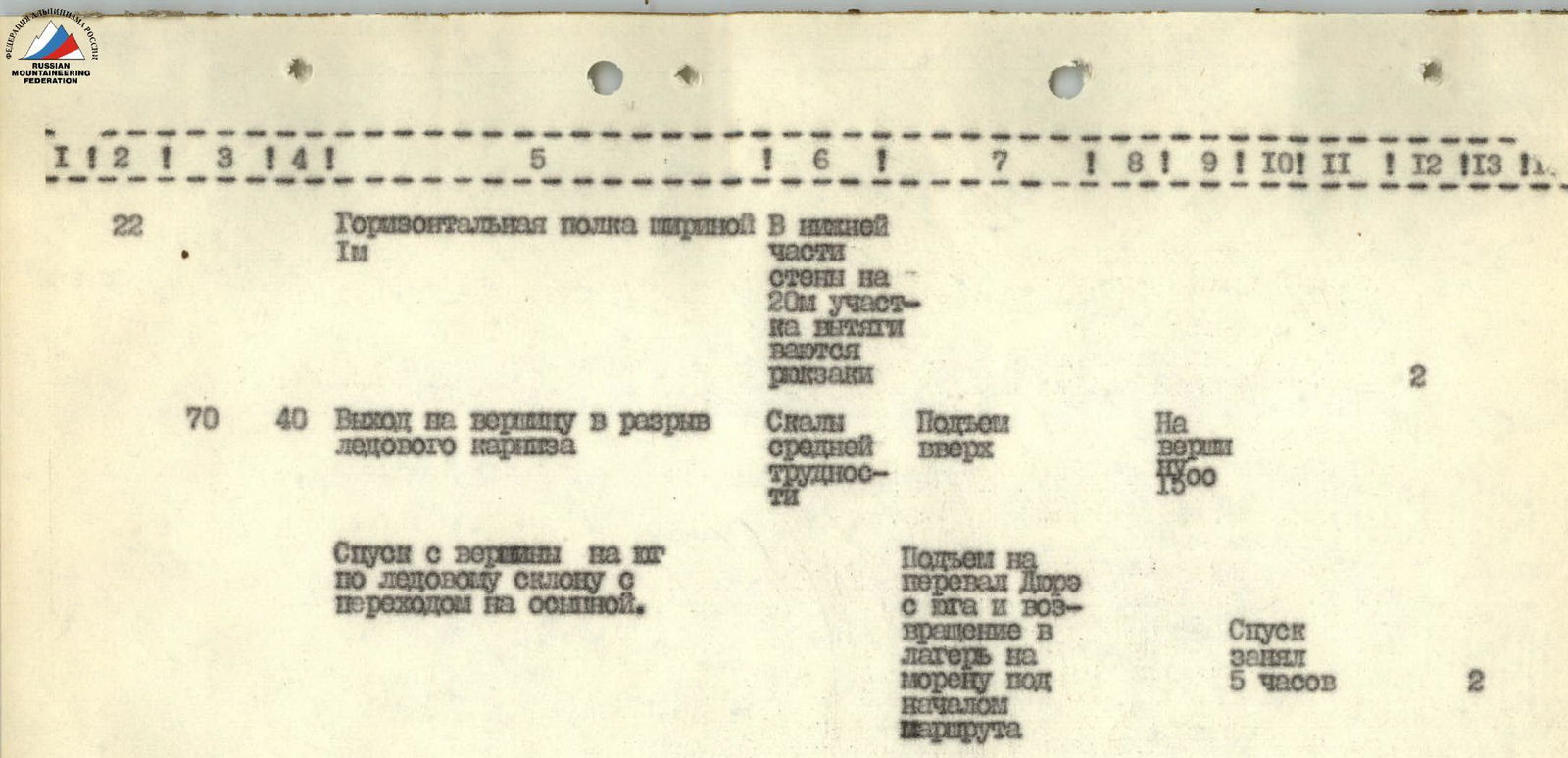
| 17 | Aug 16 | Inclined talus platform | Arrangement of overnight stay and further route processing on 2 ropes. | 16:30 | 2 | 1 overnight stay on inclined platform. | |||||
| 18 | 75–80 | 15 | Rock wall | Difficult rocks with limited holds. Movement up-left 5 m and ascent along wall. | 3 | ||||||
| 19 | 65 | 20 | Internal corner with tile-like rock structure. Small overhanging cornices. Ends on narrow short rock shelf. | Difficult rocks. Corner passed using ladders. Backpacks pulled up. | 6 | ||||||
| 20 | 4 | Steep wall | Difficult rocks, no cracks for hooks. Ascent up under wall. | 3 | |||||||
| 21 | 50 | 35 | Rock wall of stepped structure (short walls alternate with ledges). Leads to ridge. | Easy rocks. Ascent up along wall. Ledges convenient for belaying. | 2 | ||||||
| 22 | 50 | 25 | Ridge section | Easy rocks. Ascent along ridge. | 2 | ||||||
| 23 | 60 | 15 | Groove filled with rimaye ice | Passage complex. Ascent along groove. Hook belaying. | 2 | 3 | |||||
| 24 | 60 | 10 | Ice slope with exit to narrow inclined ledge 0.5 m wide and 15 m long (photo 5) | Ascent along ice slope and traverse along ledge to left. Hook belaying. | 2 | ||||||
| 25 | 90 | 30 | Rock wall | Limited holds and cracks for hooks. 15 m straight up, next 15 m traverse up-left. | 5 | ||||||
| 26 | 50 | 40 | Internal corner filled with rimaye ice | Complex passage. Ascent along internal corner to ridge. | 2 | 2 |
| № | Date | Steepness of section in degrees | Length of section in meters | Characteristics of sections and conditions of their passage by relief character | Technical overcoming and belaying | Conditions on mountain/bivouac | Time (hours) | Driven hooks, pcs. | Used perils, m | Number of overnight stays | General bivouac conditions |
|---|---|---|---|---|---|---|---|---|---|---|---|
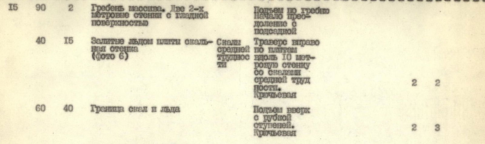
| 27 | Aug 16 | 90 | 2 | Ridge. Two 2-meter walls with smooth surface. | Ascent along ridge. Start of overcoming with laddering. | 2 | |||||
| 28 | 40 | 15 | Ice-filled slabs of rock wall (photo 6) | Rocks of medium difficulty. Traverse to right along slabs, along 10-meter wall with rocks of medium difficulty. Hook belaying. | 2 | 2 | |||||
| 29 | 60 | 40 | Boundary of rocks and ice | Ascent up with step cutting. Hook belaying. | 2 | 3 | |||||
| 30 | Ice ridge leading to pre-summit rock massif | ||||||||||
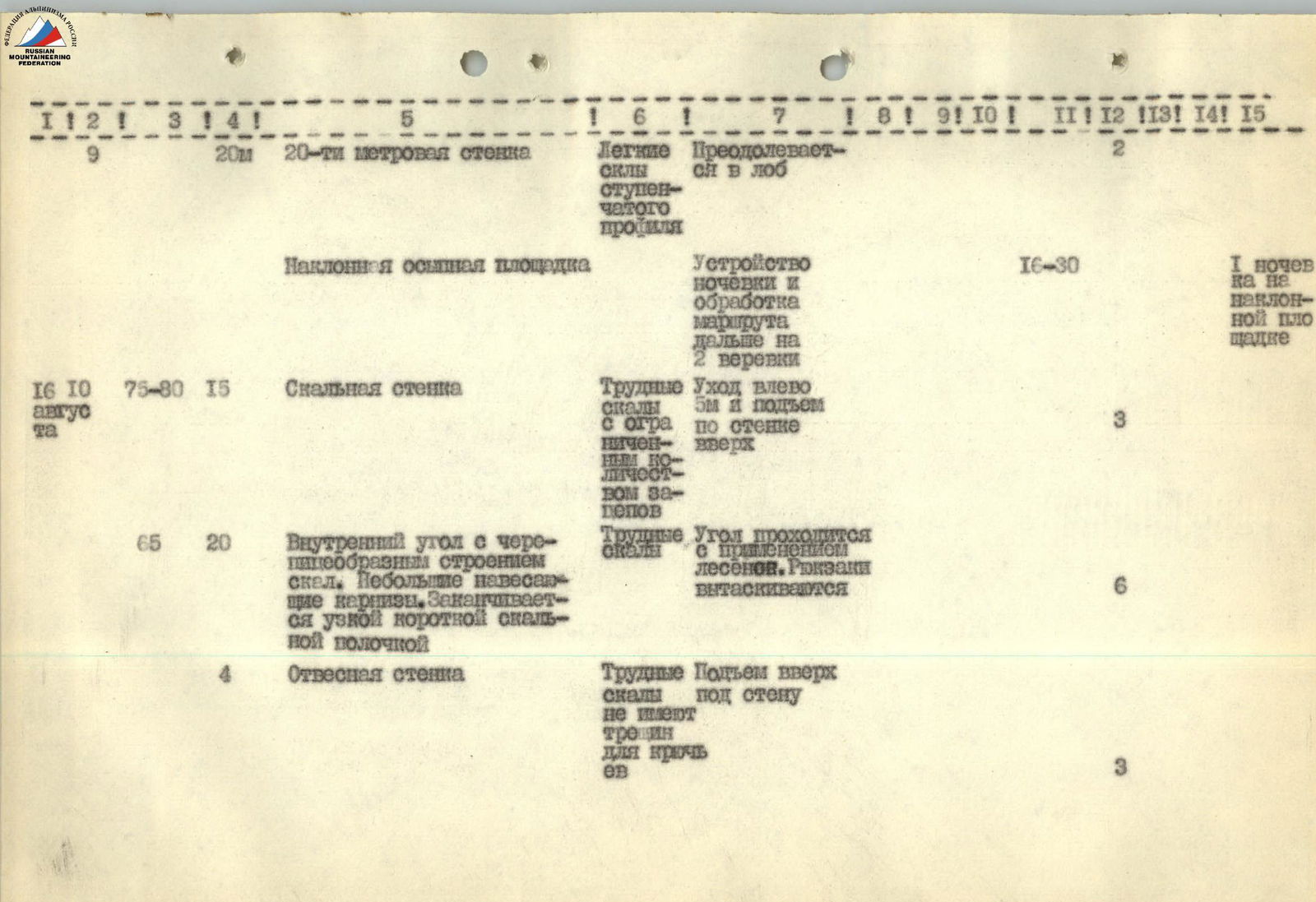
| 31 | 20 | 20 | 1st section of ridge | Step cutting, on crampons. | 2 | ||||||
| 32 | 65 | 45 | 2nd section of ridge (photo 7–8) | Hook combination. | 2 | 3 | |||||
| 33 | Aug 17 | 50 | 30 | Rock wall, heavily destroyed rocks | Medium difficulty. Up-right. | 2 |
| № | Date | Steepness of section in degrees | Length of section in meters | Characteristics of sections and conditions of their passage by relief character | Technical overcoming and belaying | Conditions on mountain/bivouac | Time (hours) | Driven hooks, pcs. | Used perils, m | Number of overnight stays | General bivouac conditions |
|---|---|---|---|---|---|---|---|---|---|---|---|
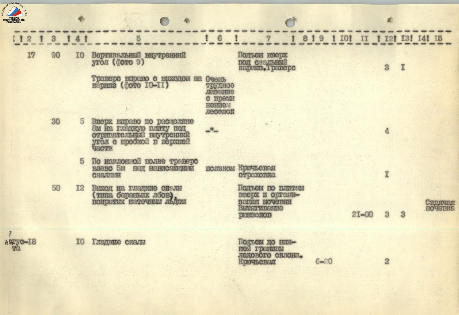
| 34 | 90 | 10 | Vertical internal corner (photo 9) | Ascent up under rock cornice. Traverse. | 3 | 1 | |||||
| 35 | Traverse to right with exit to cornice (photo 10–11) | Very difficult climbing using ladders. | 4 | ||||||||
| 36 | 30 | 5 | Up-right along crevice 8 m onto smooth slab under negative internal corner with pit in upper part. | ||||||||
| 37 | 5 | Traverse to left 5 m along inclined ledge over overhanging rocks. | Crawling. Hook belaying. | 1 | |||||||
| 38 | 50 | 12 | Exit onto smooth rocks (like "sheep's foreheads"), covered with rimaye ice. | Ascent along slabs up and arrangement of overnight stay. Pulling up backpacks. | Sitting overnight stay. | 21:00 | 3 | 3 | |||
| 39 | Aug 17 | 10 | Smooth rocks | Ascent to lower boundary of ice slope. Hook belaying. | 6:20 | 2 |
| № | Date | Steepness of section in degrees | Length of section in meters | Characteristics of sections and conditions of their passage by relief character | Technical overcoming and belaying | Conditions on mountain/bivouac | Time (hours) | Driven hooks, pcs. | Used perils, m | Number of overnight stays | General bivouac conditions |
|---|---|---|---|---|---|---|---|---|---|---|---|
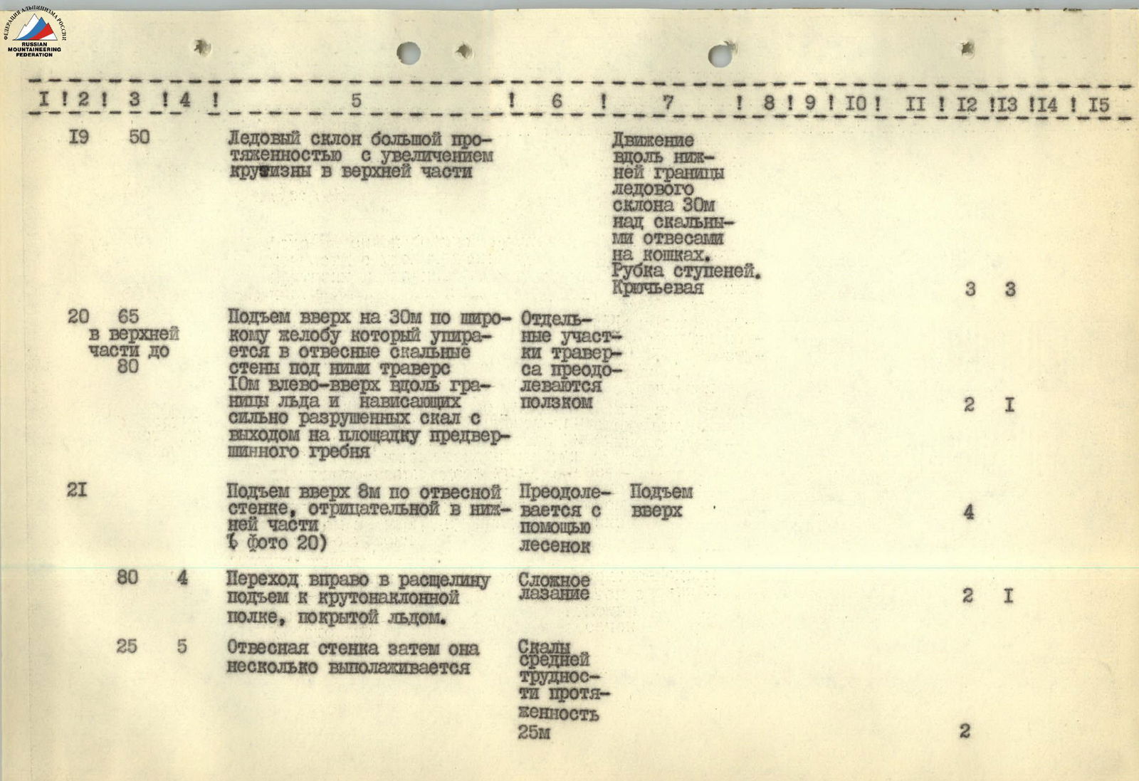
| 40 | 50 | Ice slope with large extent, increasing in steepness in upper part. | Movement along lower boundary of ice slope 30 m over rock cliffs on crampons. Step cutting. Hook belaying. | 3 | 3 | ||||||
| 41 | 65 (in upper part up to 80) | 30 | Ascent up 30 m along wide groove, which abuts against steep rock walls. Under them, traverse 10 m to left-up along boundary of ice and overhanging, heavily destroyed rocks, exiting onto platform of pre-summit ridge. | Some sections of traverse overcome by crawling. | 2 | 1 | |||||
| 42 | 8 m | Ascent up 8 m along steep wall, negative in lower part (photo 20) | Overcome using ladders. Ascent up. | 4 | |||||||
| 43 | 80 | 4 | Transition to right into crevice, ascent to steeply inclined ledge covered with ice. | Complex climbing. | 2 | 1 | |||||
| 44 | 25 | 5 | Steep wall, then it becomes less steep. | Rocks of medium difficulty, 25 m long. | 2 |
| № | Date | Steepness of section in degrees | Length of section in meters | Characteristics of sections and conditions of their passage by relief character | Technical overcoming and belaying | Conditions on mountain/bivouac | Time (hours) | Driven hooks, pcs. | Used perils, m | Number of overnight stays | General bivouac conditions |
|---|---|---|---|---|---|---|---|---|---|---|---|
| 45 | 70 | 40 | Exit onto summit in break of ice cornice. | Rocks of medium difficulty. Ascent up. | On summit at 15:00 | 2 | |||||
| - | Descent from summit to south along ice slope, transitioning into talus. | Ascent to Dure pass from south and return to camp on moraine under beginning of route. | Descent took 5 hours. | 2 |
OVERALL ASSESSMENT OF THE ACTIONS OF THE ASSAULT GROUP DURING THE ASCENT
The team consisted of highly qualified athletes with many years of climbing experience. This ascent was preceded by training in the Middle Talgar area, where joint ascents to peaks of category 5B difficulty were undertaken. Thus, the team was well-prepared for passing the new route.
The group divided into pairs as follows:
- Belovol – Popenko.
- Ilinsky – Polnov.
Since the pairs were equally capable, the first to ascend were Polnov, Belovol, and Popenko (the first person did not change throughout the day). During the ascent, the pairs acted in harmony, with good mutual understanding. There were no disciplinary violations.
RECOMMENDATIONS FOR SUBSEQUENT CLIMBERS
- Due to the danger of rockfall under the wall, it is recommended to start the route no later than 7:00
Comments
Sign in to leave a comment