Northern Tien Shan, Trans-Ili Alatau
Peak Yoshkar-Ola via the Southwest Wall
4B category of difficulty
Ascent Passport
- Region, gorge, section number according to the classification table of 20__ year — Northern Tien Shan, Trans-Ili Alatau, Maloe Almatinskoe gorge.
- Name of the summit, its height, name of the route: Peak Yoshkar-Ola 3950 m, via the large angle of the West Wall
- Proposed: 4B category of difficulty
- Characteristics of the route: rock
- Height difference of the route: 250 m
Route length: 500 m. Length of sections:
- V category of difficulty — 60 m
- VI category of difficulty — 0 m. Average steepness:
- main part of the route — 75°
- entire route — 50°
- Pitons left on the route:
total 3; including bolted — 0
- Team's travel hours: 7 hours
- Leader: Gennadi Durov, Candidate Master of Sports
Members: Boris Dedeshko, Candidate Master of Sports; Alexander Chechulin, 1st sports rank
- Coach: Denis Urubko
- Exit to the route from the base camp:
Route started: August 25, 2010. Summit ascent: August 25, 2010. Return to base camp: August 25, 2010. Descent from the summit: via the 1B category route;
# Scheme of the Route
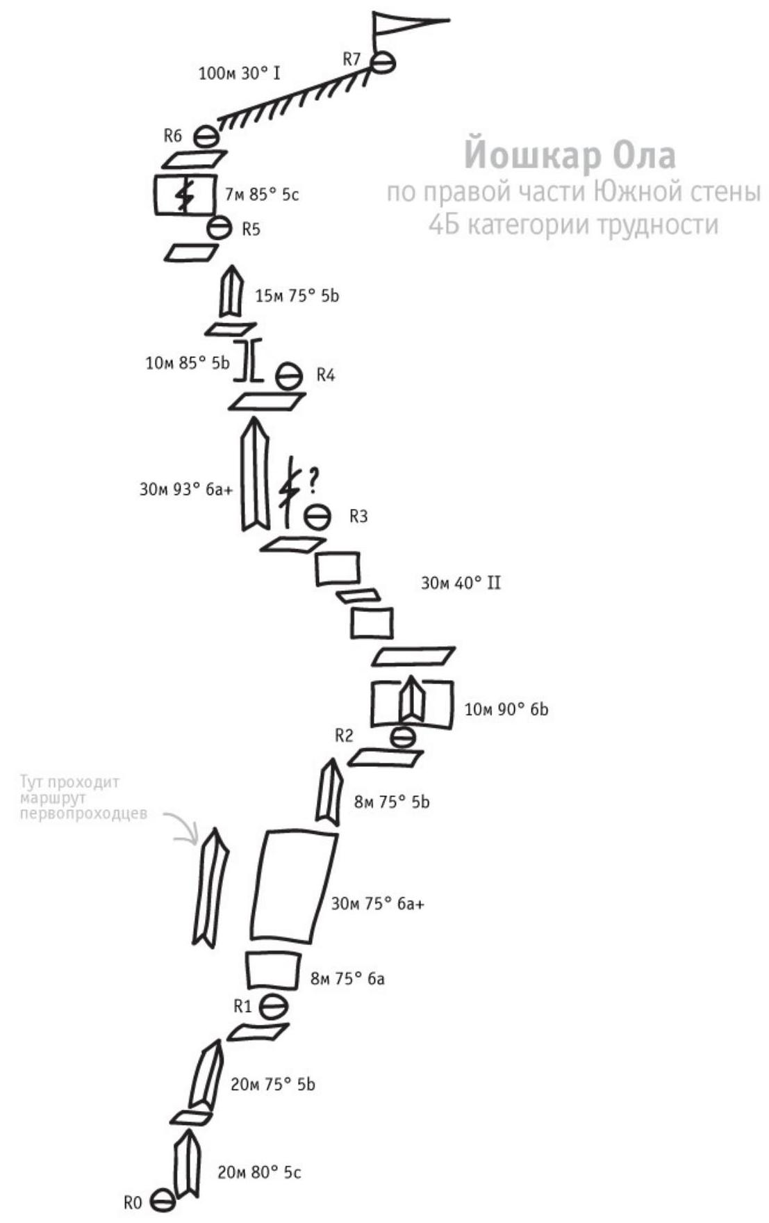
Description
R0–R1
Start along the inner angle. In the lower part of the wall, the angle is smoothed. Higher, the rock becomes more destroyed, but the relief becomes gentler. Then, along the angle, up to the right, to the exit to the ledge.
R1–R2
There are two options for passing this section.
- The first — along the wall above the station, go up to the left, into the inner angle.
- The second — along the wall above the station, move vertically up.
In the first case, you will have to climb 10 m without insurance, in the second, you need to climb along a steeper relief, but with insurance. The second option is described below.
R2–R3
The previous section leads to a convenient ledge. From it, vertically up along the steep inner angle, rise several meters.
The angle leads to a large scree ledge, from which a system of walls and ledges goes up to the left. Along them, exit to the ledge, from which a smooth wall with a wide crack goes up.
R3–R4
From the ledge, go slightly to the left, into the inner angle. The angle slightly overhangs.
Immediately after the exit from the angle — a large ledge with many large stones.
R4–R5
From the ledge, up to the left along the walls and ledges to the inner angle. Along it, up to the ledge, where you need to make a station.
R5–R6
From the ledge, along a short steep wall, climb to the "roof".
R6–R7
In a rope team, along the ridge to the summit. Descent along the 1B route to the saddle between Yoshkar-Ola and Amangeldy and then to Alpinist or along the couloir to the road.
Wall part of the route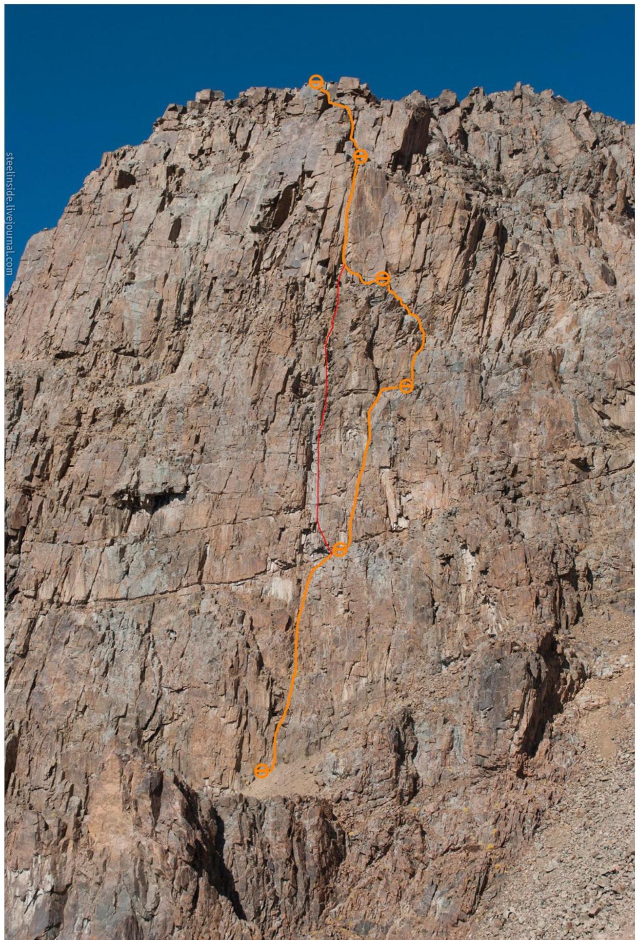
Digitized from Google