
Ascent Passport
- North Tian-Shan, Trans-Ili Alatau, Malo-Almatinsky spur
- Peak Kholodnye Perya (3850 m), via the center of the South Face
- Category III complexity
- Route type — rock climbing
- Route height difference — 180 m
Route length — 256 m Length of sections:
- Category V complexity — 3 meters Average steepness:
- main part of the route — 75 degrees
- entire route — 55 degrees
- Pitons left on the route: total — 0, bolted — 0
Pitons used:
| Rock | Bolt | Ice | Stopper Elem. | |
|---|---|---|---|---|
| Free | ||||
| Belay | 5 | 0 | 0 | 7 |
| Self-belay | 0 | 0 | 0 | 0 |
- Team's total climbing hours on the route: 5 h 30 min
- Participants:
Urubko Denis — Master of Sports of International Class — leader, Grinevich Denis — 1st sports category, Chechulin Alexandr — 1st sports category, Kositsyn Alexandr — 3rd sports category
- Team coach:
Urubko Denis — CSKA MO RK
- Route start: October 19, 2008 — 11:00
Summit: October 19, 2008 — 16:30. Descent to Tuyuksu base camp: October 19, 2008 — 22:30
Route photograph

View from the Southeast, from a distance of about 3000 m from the summit (photograph taken from the slope of Peak Mayakovsky during the ascent via "Telnyshka")
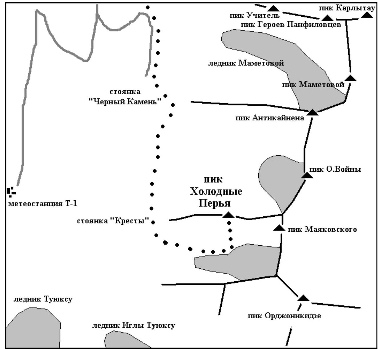
Ascent area map
Ascent description
The approach was made via the road through:
- Mynzhylky weather station,
- "Cherny Kamen" ("Black Stone") stand,
- south along the trail to the "Kresty" ("Crosses") stand.
Then turned east and moved to the ice takeoff before Peak Mayakovsky. Here is the base of Peak Kholodnye Perya.
The start of the route is a clearly defined black-colored wall, 30 m wide and 10 m high. All other surrounding rocks are brown.
The team started the route at 11:00. With simultaneous belay, they moved (sections R1–R10) to the beginning of the steep part. Then they worked on organizing a fixed belay. D. Grinevich was the piton hammer.
Through the chimney of the upper part, they climbed onto the ridge, along which, after 40 m, the group reached the summit at 16:30.
In very bad weather conditions, lack of visibility, and lack of crampons for working on icy rocks, it was decided to descend via the ascent route.
- At 19:00, the group descended to the start of the route.
- By 22:30, they reached the Tuyuksu base camp.
There were no falls, injuries, or illnesses.
Route diagram in UIAA symbols

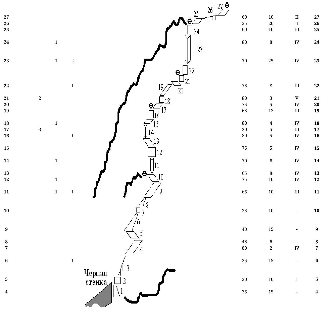
3 2 1 1 55 8 2 5 1 55 8 2 55 8 15 1 1 55 15 1 55 1 55 1 1 1 1 1 1 1 1 1 1 1 1 1 1 1 1 1 1 1 1 1 1 1 1 1 1 1 1 1 1 1 1 1 1 1 1 1 1 1 1 1 1 1 1 1 1 1 1 1 1 1 1 1 1 1 1 1 1 1 1 1 1 1 1 1 1 1 1 1 1 1 1 1 1 1 1 1 1 1 1 1 1 1 1 1 1 1 1 1 1 1 1 1 1 1 1 1 1 1 1 1
Comments
Sign in to leave a comment