Ascent Passport
I. Ascent class: technical 2. Ascent area: Zailiyskiy Ala-Tau 3. Peak: Tруд 4650 m via the left part of the West wall, first ascent.
- Proposed difficulty category: 5B.
- Route characteristics:
Height difference 1010 m. Average steepness 65°. Total route length — 1190 m. Length of sections with 4th difficulty category — 330 m, 5th difficulty category — 480 m.
- Pitons hammered: insurance and others
- Rock pitons — 27
- Ice pitons — 2
- Chocks — 47
- Climbing hours — 16
- Number of nights — 1 (overnight bivouac)
- Leader — POPOV PAVEL MIKHAILOVICH — CMS (Candidate for Master of Sports)
Team members:
- GURIEV SERGEY ANATOLIEVICH — CMS
- CHESNOKOV MIKHAIL PETROVICH — CMS
- Pershkevich ALEKSEY YAKOVLEVICH (CMS) — gr.
- Team coach: BERMAN S. P. — MS (Master of Sports)
- Dates of departure and return — August 27, 1984
— August 28, 1984
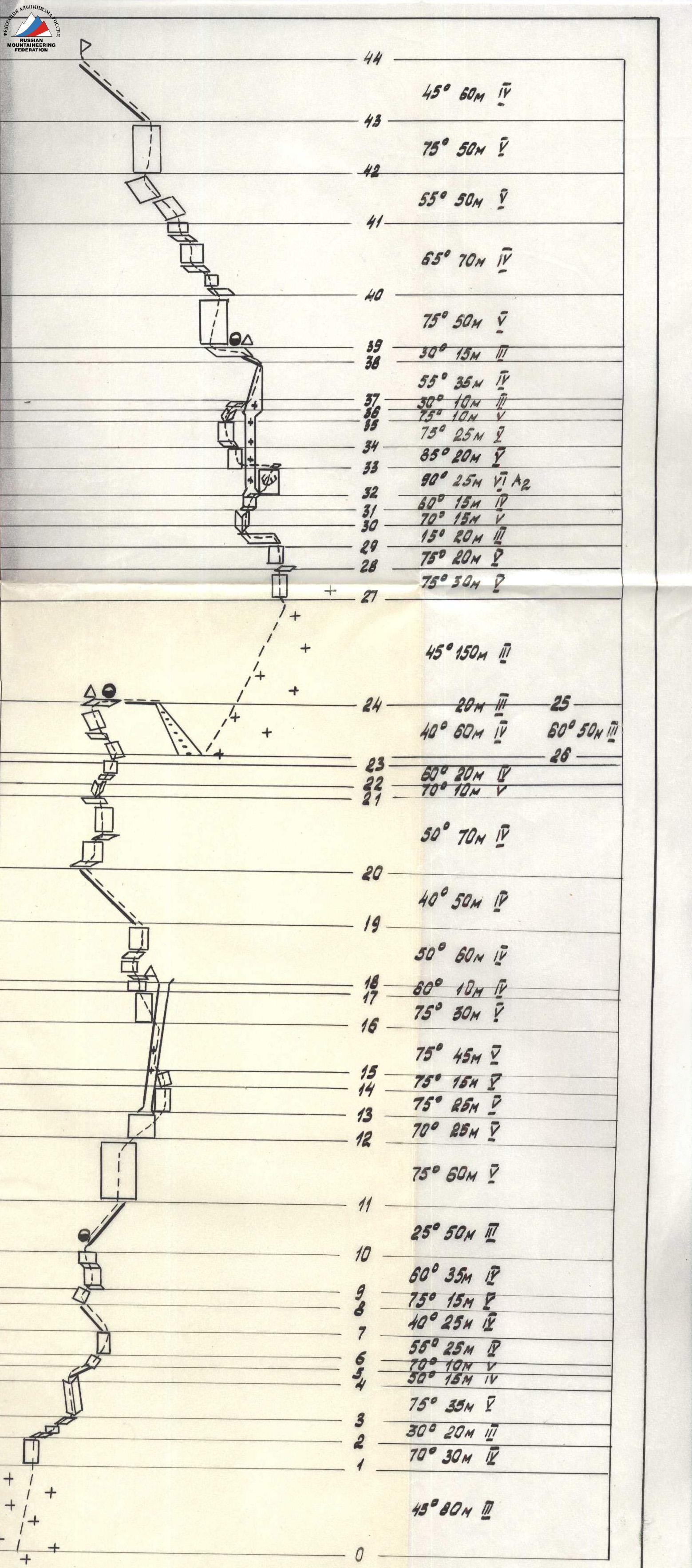
44
45° 60 m 4
43
75° 50 m 5
42
55° 50 m 5
41
65° 70 m 4
40
75° 50 m 5
39
30° 15 m 4
38
55° 35 m 4
37
30° 10 m 5
36
75° 10 m 5
35
75° 25 m 5
34
85° 20 m 5
33
90° 25 m 6 A2
32
60° 15 m 5
31
70° 15 m 5
30
15° 20 m 5
29
75° 20 m 5
28
75° 30 m 5
27
45° 150 m 3
26
60° 50 m 5
25
40° 60 m 4
24
20 m 5
23
60° 20 m 4
22
70° 10 m 5
21
50° 70 m 4
20
40° 50 m 5
19
50° 60 m 4
18
80° 10 m 4
17
75° 30 m 5
16
75° 45 m 5
15
75° 15 m 5
14
75° 25 m 5
13
70° 25 m 5
12
75° 60 m 5
11
25° 50 m 3
10
60° 35 m 5
9
75° 15 m 5
8
40° 25 m 5
7
55° 25 m 5
6
70° 10 m 5
5
50° 15 m 4
4
75° 35 m 5
3
30° 20 m 3
2
70° 30 m 3
1
45° 80 m 3
0

S.V. TALGAR
Tруд 4650
ASCENT ROUTE 1984
5B category
Classified route
Yuna's Route (Novosibirsk "Tруд") 1982, 5B
V. Gorbunov's Route (Alma-Ata "Lokomotiv") 1983

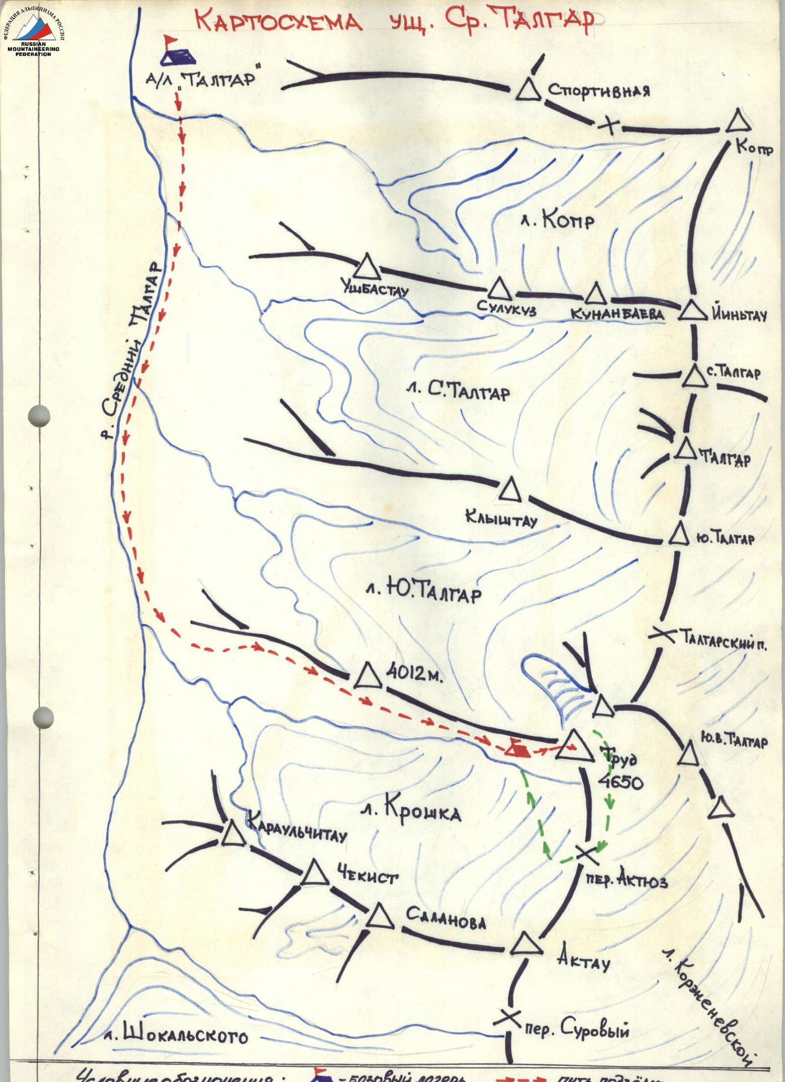
Map of the Sredny Talgar valley
A/L "Talgar" Sports l. Kopr Ushbastau Sulukuz Kunanbaeva Yin'tau l. S. Talgar S. Talgar Talgar Klyishtau Yuzhny Talgar l. Yuzhny Talgar 4012 m. Talgarskiy peak Tруд 4650 l. Kroshka Karaulchitaou Chekist Atyuz pass Salanova Aktau South-East Talgar l. Shokal'skogo l. Korzhenevskoi Suroviy pass Symbols: — Base camp — ascent route
Ascent area
Peak Tруд (4650 m) is located in the Sredny Talgar valley, the southern and eastern parts of which border the main ridge of Zailiyskiy Ala-Tau in the North Tien Shan system. The ridge reaches its maximum heights (Talgar peak 4987 m) and maximum glaciation (Korzhenevsky glacier, Bogatyri, Shokal'skogo) in the upper reaches of the named valley. Peak Tруд is situated in the upper reaches of the Yuzhny Talgar and Kroshka glaciers. The traversed West wall faces the Kroshka glacier.
Three routes of 5B category have been ascended via the West wall: via the center of the West wall; via the right part of the West wall in 1982 (Yuna V.M., Novosibirsk "Tруд") and in 1983 (Gorbunov V.A., Alma-Ata "Lokomotiv").
The route ascended by the team via the left part of the West wall runs parallel to the central route on the West wall.
Preparation for the ascent
Team members trained independently until the summer season. During the summer season, team members completed ascents near Alma-Ata with 3–4 categories of difficulty, and from June 30, the team, in its declared composition, underwent a training camp in Kyrgyz Ala-Tau, completing a training ascent to the peak Teke-Tor (4A category) and Bachichikei (5B category). However, due to participation in rescue operations in the Ala-Archa alpine camp area, some team members fell ill, and the team was unable to complete the declared route via the North wall of peak "Svobodnaya Koreya". Returning to the Talgar alpine camp and working with detachments, team members completed an ascent to Talgar peak (5B category). Inspection of the second ascent object, Talgar peak, via a new route, revealed high rockfall danger due to very hot weather in August. However, to participate in the competition, the team, in agreement with the Zailiyskiy Region Climbing Committee, chose a new route to peak Tруд via the left part of the West wall for their record ascent. Due to the withdrawal of some team members, the leader was replaced, and participant Pershkevich A.Ya. from the public rescue team of the Zailiyskiy Region Climbing Committee was added. The team, in this reconstructed composition, completed the record ascent.
Tactical actions of the team
The route was traversed according to a tactical plan, taking into account the situation during the ascent. All sections were ascended using free climbing. The first climber moved without a backpack, using a double rope. Ropes were used throughout the route, and team members climbed with backpacks using jumar ascenders to speed up the ascent, given their high individual physical and technical preparedness.
Favorable weather conditions during the ascent allowed maximum use of daylight; the team's coordinated work ensured the route was completed in 1.5 days. On the route, the team worked in pairs: POPOV P.M. — GURIEV S.A. and CHESNOKOV M.P. — PERSHKEVICH A.Ya. These pairs had shared ascents with 5B category difficulty over the past three years.
POPOV P.M. — CMS in rock climbing — multiple champion of Kazakhstan in Dombay pairs, participant in USSR Championships — led most of the route.
CHESNOKOV M.P. — CMS in rock climbing — was the leader of the second pair.
The high pace of the leading pair made the movement along the ropes continuous, without delays. There were no falls or injuries on the route.
To enhance safety, chocks were used. The overnight bivouac was organized after passing an internal corner, before reaching the ridge, on a ledge.
Communication with the camp and the observation group was maintained via "Karat-m" radios according to the schedule and was stable.
Route description
The path to the summit from the "Talgar" alpine camp goes up the valley to the Kroshka glacier. Along the glacier, to the left, under the wall of peak 4012. 300 m from the wall of peak Tруд, on the moraine, is the bivouac site.
Section R0–R1. Movement along the rocks through an icy couloir in crampons. Crossing the couloir with insurance on ice screws.
Section R1–R2. Internal corner, exit left to an inclined slab. Insurance — stoppers and pitons.
Section R2–R3. Movement right and up along flattening slabs.
Section R6–R7. Right, a slab with few holds, then straight up a crack, piton placement is limited, ascended in crampons (very difficult in bad weather).
Section R7–R8. Steep inclined slabs, rocks are solid.
Section R8–R9. Inclined slabs, piton insurance.
Section R9–R10. Crossing a couloir, possible rockfall! 2nd control point.
Section R10–R11. Vertical wall, pitons and chocks, move left.
Section R11–R12. Key section of the route, chocks and channel pitons (very, very difficult in bad weather). Possible diversion to the classified route to the right. Internal corner, rocks are solid.
Section R12–R13. Exit to a ledge for an overnight bivouac, 15 m on a slab on the ridge — 3rd control point.
Section R13–R14. Inclined slabs.
Section R14–R15. Rocks are complex, climbing is extreme on friction (impassable in bad weather), possible diversion to the right.
Section R15–R16. Steep ridge, rocks of medium difficulty.
Section R16–R17. Steep ridge, destroyed, be cautious!
Section R17–R18. Exit to the pre-summit ridge and to the summit. Possible simultaneous movement.
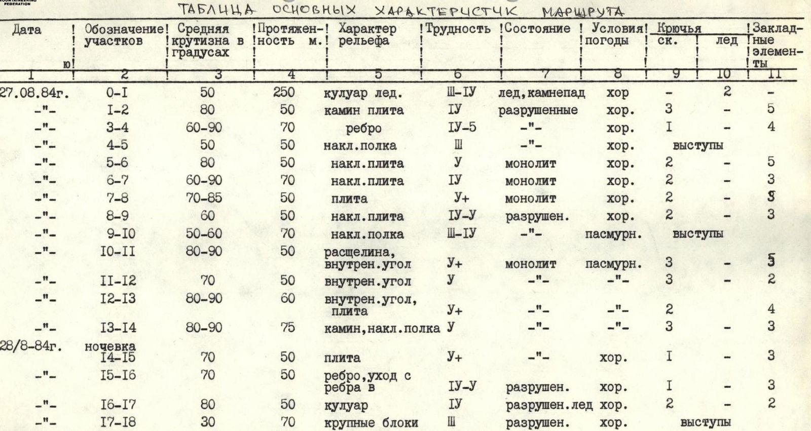
Table of main route characteristics
| Date | Section designation | Average steepness in degrees | Length, m | Terrain characteristics | Difficulty | Condition | Weather conditions | Rock pitons | Ice pitons | Chocks |
|---|---|---|---|---|---|---|---|---|---|---|
| August 27, 1984 | R0–R1 | 50 | 250 | icy couloir | 3–4 | ice, rockfall | good | – | 2 | – |
| R1–R2 | 80 | 50 | chimney, slab | 4 | destroyed | good | 3 | – | 5 | |
| R3–R4 | 60–90 | 70 | edge | 4–5 | – | good | 1 | – | 4 | |
| R4–R5 | 50 | 50 | inclined ledge | 3 | – | good | ledges | – | – | |
| R5–R6 | 80 | 50 | inclined slab | 5 | monolithic | good | 2 | – | 5 | |
| R6–R7 | 60–90 | 70 | inclined slab | 4 | monolithic | good | 2 | – | 3 | |
| R7–R8 | 70–85 | 50 | slab | 5+ | monolithic | good | 2 | – | 5 | |
| R8–R9 | 60 | 50 | inclined slab | 4–5 | destroyed | good | 2 | – | 3 | |
| R9–R10 | 50–60 | 70 | inclined ledge | 3–4 | – | overcast | ledges | – | – | |
| R10–R11 | 80–90 | 50 | crack, internal corner | 5+ | monolithic | overcast | 3 | – | 5 | |
| R11–R12 | 70 | 50 | internal corner | 5 | – | – | 3 | – | 2 | |
| R12–R13 | 80–90 | 60 | internal corner, slab | 5+ | – | – | 2 | – | 4 | |
| R13–R14 | 80–90 | 75 | chimney, inclined ledge | 5 | – | – | 3 | – | 3 | |
| August 28, 1984 | overnight bivouac | – | – | – | – | – | – | – | – | – |
| R14–R15 | 70 | 50 | slab | 5+ | – | good | 1 | – | 3 | |
| R15–R16 | 70 | 50 | edge, exit from edge | 4–5 | destroyed | good | 1 | – | 3 | |
| R16–R17 | 80 | 50 | couloir | 4 | destroyed, ice | good | 2 | – | 2 | |
| R17–R18 | 30 | 70 | large blocks | 3 | destroyed | good | ledges | – | – |
Leader — P. Popov