Tian Shan, Trans-Ili Alatau Range
TALGAR (Main Peak), 4973 m, via the west face of the North Peak from the North Talgar Glacier (Pelevin's route)
5B difficulty category.
Team of the "Malachite" sports club. Team captain - Vladimir Ivanovich YUSHKEVICH, 1st sports category. Team members:
- German Petrovich AVERYANOV, Candidate Master of Sports
- Alexey Vladimirovich ARTAMONOV, 1st sports category
- Boris Vladimirovich DAUTER, Master of Sports
- Sergey Borisovich LYAKHOV, 1st sports category
Senior coach - B.V. DAUTER, Master of Sports of the USSR
1977 year
General view of the west face (lower part) of Talgar North Peak
Geographic and Alpinist Description of the Area
The Talgar massif (translated from Kazakh as "wide, wide place") is located in the Trans-Ili Alatau range, the northernmost range of the Tian Shan mountain region. In the Talgar peaks area on the northern slope of the Trans-Ili Alatau range, in the Middle Talgar river gorge, 47 km from Almaty, at an altitude of 2650 m above sea level, there is the "Talgar" alpine camp, formerly known as "Metallurg Vostoka".
From Almaty, take a 25 km bus ride to the east to the city of Talgar, then 6 km south on the highway to the cordon of the state reserve. Here, the Left Talgar and Right Talgar rivers merge. Another 4 km along the Right Talgar river on the highway leads to the transfer base of the "Talgar" alpine camp. At this point, the Right Talgar river is joined by its tributary, the Middle Talgar river, along whose bank a mountain trail runs. 12 km along this trail to the south through a picturesque gorge leads to the alpine camp.
The Middle Talgar river flows from south to north and originates from the Shokalsky Glacier, located on the northern slopes of the Trans-Ili Alatau range, which in this area runs east-west with Peak S. Stal'sky to the west and Peak OPTЭ to the east. From Peak S. Stal'sky, the main ridge turns sharply south, and a new spur extends north, bounding the Middle Talgar river basin to the west.
From Peak OPTЭ to Peak Ak Tau-Zailiyskiy, the main ridge forms a horseshoe shape to the north, and from Ak Tau to Metallurg peak - to the northeast. The Talgar massif is located in this section of the Trans-Ili Alatau range.
Metallurg peak is the northernmost point of the Trans-Ili Alatau range; from here, it extends southeast, forming a horseshoe shape, on the southern slopes of which the vast Korzhenevsky Glacier is located.
From Metallurg peak, a North spur extends northwest, which, together with the main ridge (from Peak OPTЭ to Metallurg peak), bounds the Middle Talgar river basin to the east.
The New spur, the western boundary of the Middle Talgar river basin, features the following peaks from north to south:
- Yubileynaya
- StreloK
- Dzhamalak
- DinamoVets
- Kop
- Academician Kurchatov
- Syputchaya
- TEU
- Dzhambul
- Kishkine
- Frunze
- S. Stal'sky
In the main ridge and its spurs - the southern and eastern boundaries of the basin - are peaks Chokan Valikhanov, OPTЭ, Ak Tau-Zailiyskiy, Salanov, Chekist, Karaulchi, the Talgar massif with its 4 peaks, and in the spurs extending from it:
- Peak 4012 (Reznikova)
- Peak Trud
- Gorina
- Klysh
- Ushbas
- Sulukuz
- Abay Kunanbaev
- Iyin. Then stand peaks Kopr and Metallurg.
In the North spur are located:
- Karatau
- Kolokol'nikova
- GTO
- Sportivnaya
As of December 31, 1976, the following routes have been classified in the area:
| Difficulty Category | Number of Routes |
|---|---|
| 1B | 6 |
| 2A | 9 |
| 2B | 10 |
| 3A | 5 |
| 3B | 7 |
| 4A | 4 |
| 4B | 8 |
| 5A | 5 |
| 5B | 5 |
All 5B category routes are associated with the Talgar massif:
- Traverse of the entire Talgar horseshoe with ascent to Karaulchi via the south face
- Trud (in the Talgar spur) via the west face
- via the SW face to the South Peak (Snesarev's route)
- via the SW face to the South Peak (Akimankov's route)
- via the W face of the North Peak to the Main Talgar peak (Pelevin's route)
History of Conquering the Talgar Massif
One of the first descriptions of Talgar belongs to P.P. Semenov-Tyan-Shansky.
The beginning of alpinist exploration of Talgar is considered to be the summer of 1938, when a group of climbers from Stalinsk (now Novokuznetsk): L. Katukhtin, G. Makatrov, I. Kropotov - first ascended the main peak of the massif via the northeast ridge through the North Peak.
In 1940, a group including G. Makatrov and V.S. Pelevin made the first traverse of the North and Main peaks of Talgar, descending for the first time via the southeast ridge.
In autumn 1943, D. Gorin's group (6 people in total) ascended the Main peak via the southeast ridge.
Further attempts by several groups to ascend Talgar's peaks ended in failure; only in 1949 did climbers from the "Metallurg" camp (now "Talgar") under the leadership of F. Lemstrem complete the second traverse of Talgar with ascent via the northwest ridge and descent to the southeast.
In 1951, A. Alekseev's group conducted a traverse from southwest to north, ascending the South Peak from the "pровал" (pit) and descending via the northeast ridge.
In August 1953, a group from the "Spartak" society: V.S. Pelevin, Master of Sports; V.L. Rubanov, Master of Sports; V.A. Nagaev, Master of Sports; K.F. Korolev, 1st sports category - pioneered a new route via the west face of the North Peak with ascent to the Main peak and descent via the southeast ridge, a route that earned the group 3rd place in the USSR climbing championship in the technically complex ascents category.
Ascent Diary
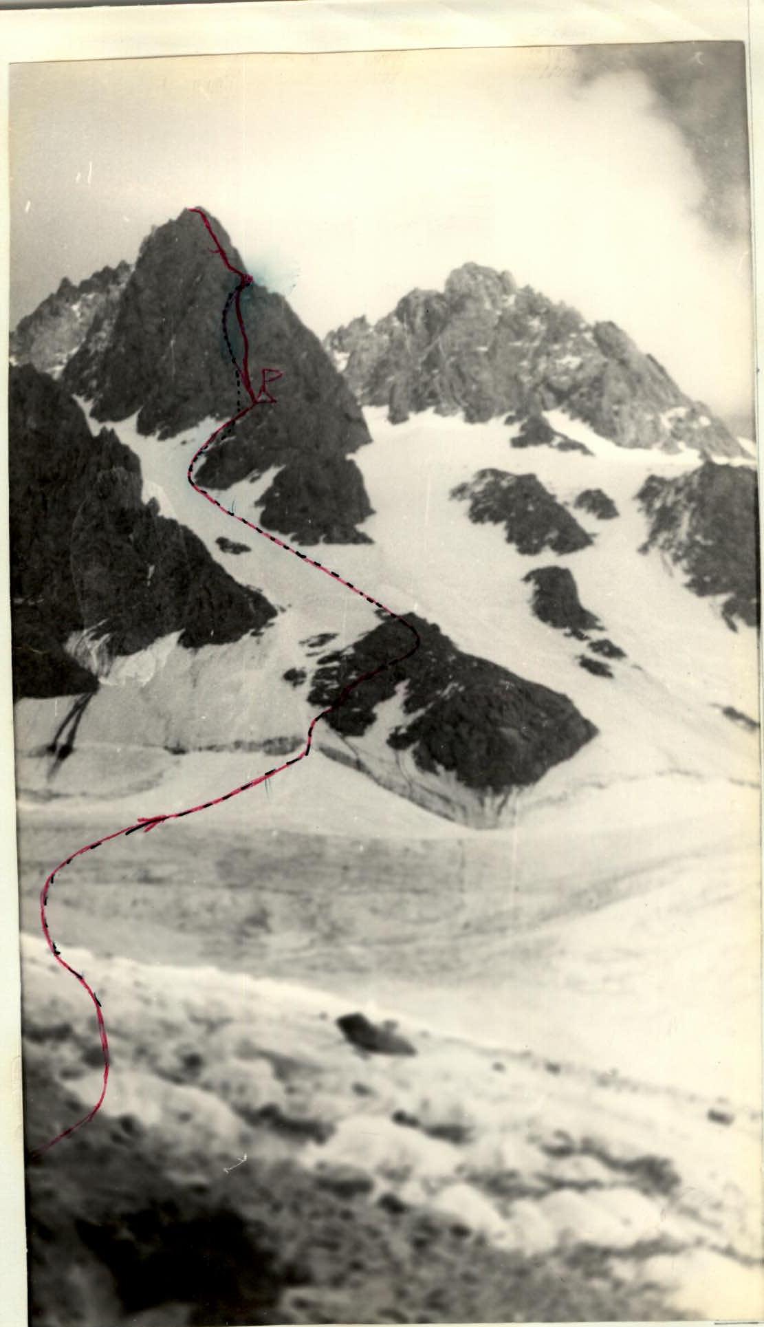
Day 1, July 19, 1977
From the "Talgar" alpine camp to the turnoff to the North Talgar Glacier is approximately 1 hour 30 minutes. Ascent via the moraine to the gentle part of the glacier - 1 hour 30 minutes. Then, 2 hours 30 minutes across the heavily crevassed glacier to the lateral, left-hand moraine, where the night's camp is set up. No traces of previous camps were found, as everything had been washed away by a mudflow. Some time was spent preparing the campsite. The remaining daylight was used to inspect the route and prepare food.
Day 2, July 20, 1977
Departure at 4:30. 1 hour across the glacier, zigzagging between crevasses towards a good landmark - the first rock island - and we reach the bergschrund. The Yushkevich - Lyakhov rope leads ahead. A belayed crossing of the crevasse and exit onto the rock island. The Artamonov - Dauter - Averyanov rope moves forward. 100 m across heavily broken rocks on the island, without removing crampons, with piton belays. The second rope follows, using the first rope's pitons, and upon reaching the ice, takes the lead again.
The ice slope is up to 40° steep. We employ the following scheme for the ropes' movement:
- The first man on the first rope (Yushkevich), placing pitons, advances 40 m, prepares a belay and double footholds for himself and the first man on the second rope (Artamonov).
- He quickly climbs the 40 m via the fixed rope and sets up a belay for the first man on the first rope to continue, while the second man on the first rope climbs simultaneously on the second rope.
- That is, the first rope moves simultaneously.
Having traversed the ice in this manner (13 ropes at about 40°, and 2 ropes up to 60° with an unreliable upper layer of friable ice that needs to be chopped to securely place pitons, which takes a lot of time) and bypassing the second rock island via steep ice, we reach the ridge of the rock island's upper part beneath the wall by 16:00.
We descend onto an ice saddle, with steep ice slopes dropping away on both sides. We chop the ice to level the campsite and settle in for the night.
Day's Summary:
- The first section of the route - an ice slope 800-900 m long, averaging 45° in steepness - is completed in 12 hours.
Day 3, July 21, 1977
While moving across the rocks, the following scheme was applied:
- The first man on the first rope (Artamonov) took on all the challenging sections.
- The first man on the second rope (Yushkevich) joined him.
- Yushkevich then allowed Artamonov to continue, while Dauter, the second man on the first rope, climbed simultaneously on the second rope.
- Then Artamonov again accepted Yushkevich.
- Lyakhov, Yushkevich's partner on the rope, moved together with Yushkevich on the first rope.
The process repeated. Averyanov followed last, removing pitons.
R1. Ice ridge and rocks of moderate difficulty directly up the wall, steepness - 60°. R2. A 4 m slab, an internal corner 6 m. Slabs with few large, smooth holds, exit onto a ledge. Average steepness - 70°.
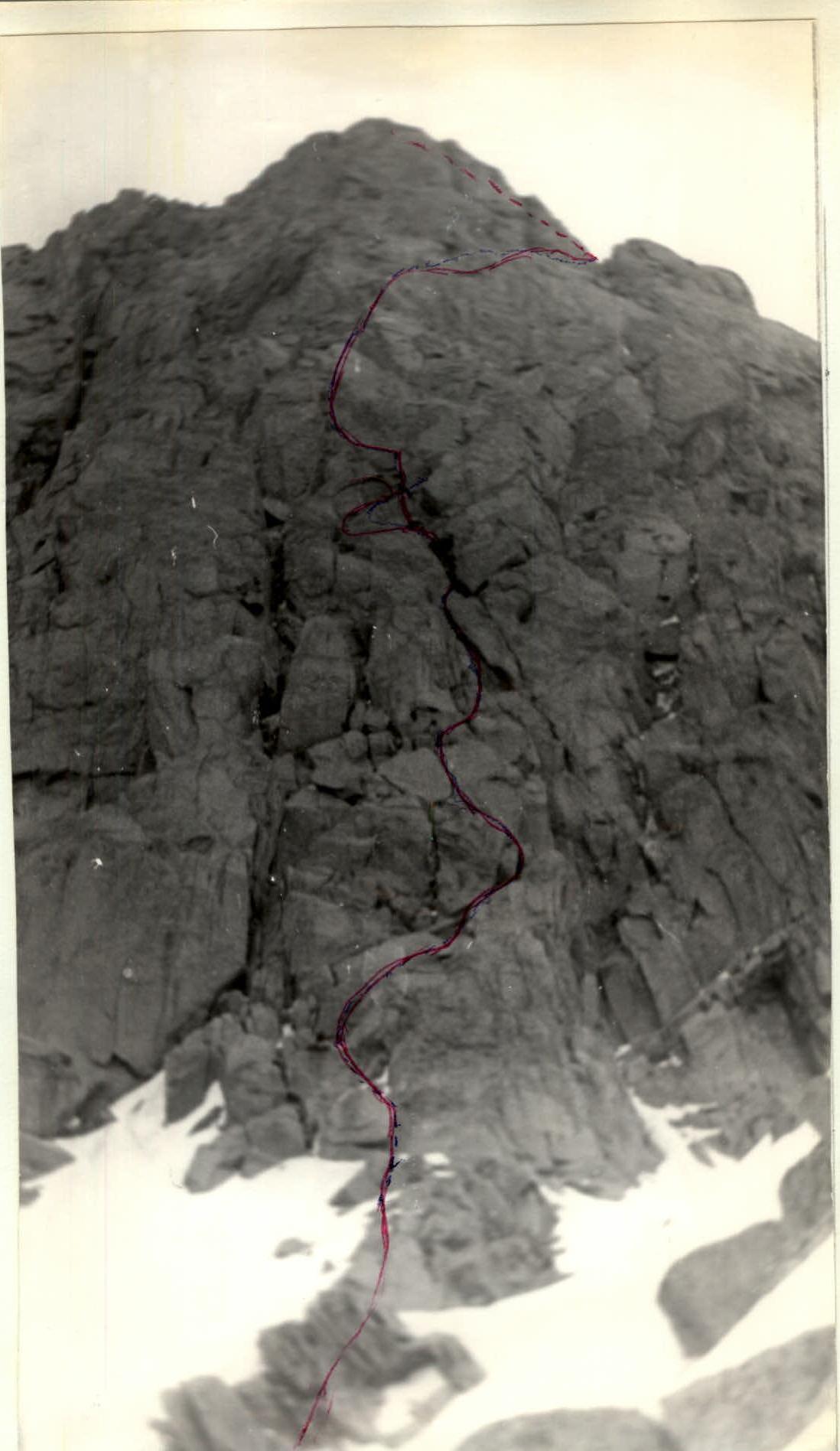
1st rock wall (view from the bivouac on the 2nd rock island)
R3. Traverse left along a small ledge 6 m. Slabs upwards to the right to a vertical internal corner, ascent to a small ledge with a difficult exit. Average steepness - 85°. R4. From the ledge, right up a vertical, iced-up chimney covered by a slab, exit to the left. Then left across slabs with verglas to an iced-up ledge beneath a wall, traverse right along it to an internal corner filled with ice. Ascent up the corner 8 m. Chopping ice from the rocks, difficult exit to the right side of the internal corner from beneath overhanging, iced-up rocks ("it overhangs!"), onto a ledge beneath the wall. Average steepness - 70°. R5. From the ledge, left across the wall. 20 m across a flake, then slabs, a 3 m wall, 90°, and left up a ledge to the base of a steep (85°, 60 m) internal corner cutting through the wall. Average steepness - 85°. R6. Straight up the corner, whose walls are smooth, with microscopic holds. In the upper part, the corner is divided by protruding rocks and slightly overhangs. Move to the left side of the corner, onto sloping slabs, exit is difficult. Average steepness - 6°.
R7. Traverse right across a ridge, an ice couloir 4 m. Another ridge and descent to the other side of the crest, across broken rocks, exit onto a shoulder. Here is a ledge for a tent, a control cairn. Time - 14:30. In 5 hours 30 minutes, the 1st rock wall, 300 m long with an average steepness of 75°, is traversed. A short rest and then onward. R8-R9. Traverse 60 m along a rock ledge alongside a tower, then ascent alongside the wall via a crack filled with ice, steepness 45–50°, then a difficult exit to the right side of the crack, which is a rock barrier up to 5 m high. Ascent up the smoothed rocks of the barrier to a small ledge. R10. Descent 3 m to the opposite side of the barrier, slightly up beneath the wall, then cross an ice couloir and exit onto a rock island. Average steepness - 60°. R11–R13. Across the rock island, via steep, iced-up slabs - difficult climbing. In the upper part, the couloir branches; go to the right of the right branch. Exit onto the ridge of the rock island, abutting the wall of a gendarme. The 2nd rock wall is traversed, average steepness 65%. R14. From the shoulder, descend 10 m right into an ice couloir bounded on the left by a rusty, overhanging rock face of the gendarme and on the right by a grey wall. Ascent 30 m up the couloir along the boundary between rocks and ice onto a horizontal saddle. R15–R16. Descent back down the couloir 10 m and pendulum traverse beneath the grey wall, exit onto it via an internal corner 5 m. Then across slabs to the right onto a small ledge, in whose left part is an ascent up a vertical internal corner 5 m, across a slab 4 m to a wall 40 m, steepness 80°. Ascent across slabs with many holds towards the right shoulder of the wall and exit onto the shoulder. Here, beneath the wall, is a small ledge where we set up a bivouac.
Thus, on the third day of the ascent, the 1st, 2nd, and part of the 3rd rock walls are traversed.
Beginning of the 2nd rock wall
Day 4, July 22, 1977
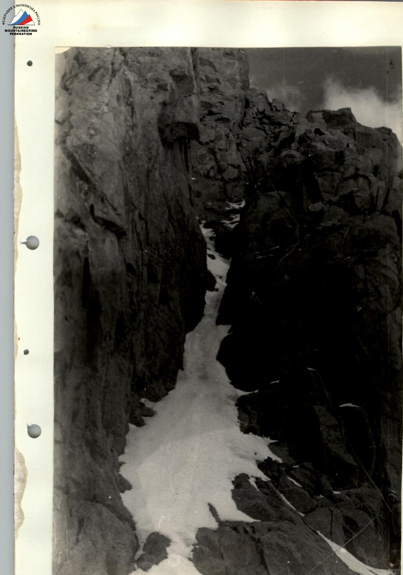
Departure from the bivouac at 10:00. Along the ledge beneath the gendarme's wall. R1, traverse with exit onto the ridge. Then 1.5 ropes along the ridge to the saddle between gendarmes. Ascent directly forward across a slab with few holds 10 m, 70°. Then across a jumble of frozen boulders with a greenish tint (very cautiously!). Exit onto a ridge leading beneath a smooth wall 80 m. Traverse right across snow-covered, rusty granite slabs 60°, 40 m, through a couloir filled with ice approximately 6 m, and exit onto a ridge. Further along an angle formed by slabs, traverse left 12 m to an internal corner with a negative right wall, ascent up it 80 m onto slabs and then traverse across steep slabs, then along a narrow ledge on a sheer wall 20 cm wide - 50 m. Exit right onto a saddle between gendarmes: a column-like gendarme to the right and a wall to the left. On the saddle, a rock outcrop 2 m high - convenient for setting up a belay. Then a 20 m wide couloir filled with ice, ascent 20 m left along the rocks, then move to a small rock ridge dividing the couloir in half, ascent up it 7 m and traverse to the right side of the couloir. Further ascent right up to a saddle 20 m, 90° beneath the wall of the "Finger" gendarme; from the saddle, up into a cleft, then along the rocks of the next ice couloir. Exit via this couloir onto a horizontal section of the rock ridge, 2 ropes long, no wider than two palms, heavily destroyed. It transitions into the snow-ice dome of the North Peak. 6–8 ropes up the slope at 20–25° and we reach the North Peak. However, upon approaching the horizontal rock ridge, the weather began to deteriorate, and by the time we descended into the broad hollow between the North and Main peaks, visibility was no more than 10 m. Following the advice of instructors from the "Talgar" camp not to "wander" on Talgar in bad weather, we set up camp in the hollow at 14:00, hoping to find a descent route early in the morning. The rest of the day was marked by hurricane-force winds, snow, and visibility not exceeding 10 m. The night brought stars and hopes for improving weather, but at 4:00–5:00 on the fifth day of the ascent, a snowstorm resumed, and visibility worsened to 15 m. After sitting on packed rucksacks until 7:00, we decided to continue.
We replaced the note in the cairn below the Main peak and, more guessing than seeing the path, descended via the southeast ridge. Knowing from the description that the descent represents a 3A category route, we attempted to find a suitable couloir, but all were icy this season, with steepness around 40°. Only at the end of the ridge did we find a more gentle (30–35° in the upper part) couloir and began our descent. The weather improved by this time. 8–9 ropes, using a mixed technique, leaving rock and in two places ice pitons in the couloir's sides, and we reached the Korzhenevsky Glacier. The descent from the peak in conditions of limited visibility to the glacier took 7 hours.
Another 1 hour 30 minutes across the Korzhenevsky Glacier, crossing numerous crevasses (4/4) or bypassing them, and we were at the Surovyy Pass. Descending from it onto the Shokalsky Glacier, then traversing the glacier, and subsequently along the moraine beneath the slopes of Peaks Salanov, Chekist, and Karaulchi, by 18:00 we were at the "Green Glade", and by 20:00 - back in camp.
Conclusion
Comparing the planned ascent route with the actual route taken reveals a good match, indicating the group's good tactical preparation.
The team was well-prepared for the route, facilitated by year-round training in Moscow, a May trip to the Crimean rocks, sufficient acclimatization before the ascent, analysis of previous ascents, and utilizing the strongest aspects of individual participants on various forms of mountain relief during the ascent.
Safety was ensured through knowledge of the route, facilitated by consultations received, correct selection of equipment, use of belays throughout the route, and skilled application of necessary technical means (slings, chocks, shovel-headed pitons, two-way radio communication). On the route, 84 ice and 123 rock pitons were placed.
The debrief showed that the team successfully completed the route. Ascent to the peak took 26 hours, descent - 12 hours.
According to team members, the route is more challenging than known routes of the same category, such as:
- to v. Ullutau (Main peak) via the north wall
- to v. Ullutau (East peak) via the north bastions of the shoulder
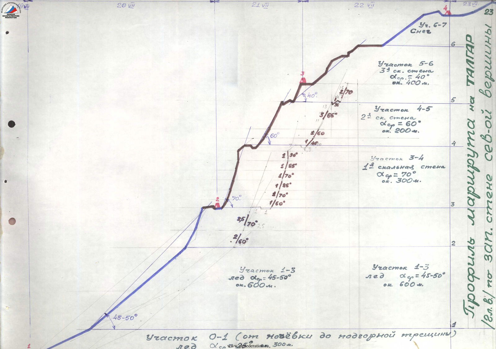
Route profile on TALGAR (Main peak) via the west face of the North Peak