Talgar (SE)
Brief geographical location and sports characteristics of the object.
The unnamed peak with a height of 4600 m, or now known as peak "Daugava" as named by the Latvian national team after their ascent, is located in the North Tien Shan, in a spur branching off to the northwest from the main ridge of the Trans-Ili Alatau. In this spur, situated south of the Talgar massif and separating the Kroshka glacier and North Talgar, there are two peaks:
- peak "Trud"
- peak "Daugava"
The northwest slope of peak Daugava drops to the north as a steep wall. Bounded on both sides by large icefalls, it presents three separate walls and several difficult-to-overcome sections in the middle part of the route. The northwest slopes are hardly ever exposed to sunlight and are battered by strong winds. As a result, there is a lot of ice on the route, and in the upper part, a lot of loose snow covering both ice and rocks. The height of the wall is 950–1050 m.
Characteristics of the area
The North Tien Shan is characterized by an abundance of snow and ice, resulting in many snow, ice, and combined routes. The action of glaciers is very pronounced. There are many moraines that block the path and hinder approaches. As a result of intense melting, the water level in rivers changes significantly. This factor must also be considered when planning ascents. The best time of year for sports ascents is considered to be July–August, although exceptions can occur.
The group was based in the Talgar mountaineering camp, located in the Middle Talgar gorge, 43 km from Almaty. From the transshipment base to the camp is a 9 km pack trail. Furthermore, most approaches from the camp to the ascent objects take one day's journey. The approach to peak Daugava took 6 hours.
Reconnaissance work
The area has long been visited by climbers and is considered well-studied, but there are still many uncharted routes. The location of peak Daugava and the approaches to it were already known to the group. It remained to study the route itself.
The first observations were made back in 1961. To study the route in detail, reconnaissance trips were conducted. Reconnaissance was carried out from three different observation points using binoculars. Only members of the assault group participated in the reconnaissance.
On July 24, from the upper plateau of the South Talgar glacier, the frontal side of the route was observed, potential bivouac sites were identified, and sketches were made. Two participants approached the beginning of the route, studying the best approach option and determining the possibilities of overcoming the bergschrund.
On July 26, reconnaissance was conducted from the spur where the peak is located. From here, the lateral profile of the route was visible.
On August 1, the final reconnaissance was conducted from Baranovsky's bivouac.
All reconnaissance from one observation point was conducted at different positions of the sun. Based on the results of the reconnaissance, an organizational and tactical ascent plan was developed.
Route progression
Along with the assault group, a group of observers consisting of four people with two radios was to set out. Communication between the assault group and observers was to be carried out using rockets.
On the appointed day, August 13, the groups set out. To ensure better radio communication with the camp, the observer group split into two parts:
- Two remained under the moraine glacier;
- Two, along with the assault group, went to its upper plateau.
Following the route, the group largely adhered to the previously developed plan. Only the timing of the route passage changed. On August 15, the group moved faster than planned and covered the section from point #8 to point #15, bypassing the previously planned bivouac #13 under the third wall. This was explained by the desire to take advantage of the good weather, as there were no guarantees that the next day would be good. Moreover, it is better to climb the north wall in the second half of the day rather than early in the morning when it is very cold.
When starting the route, the group took all the usual mountaineering equipment and new gear specially selected for this route, including:
- drillable and non-drillable pitons
- drills
- ladders
- hanging platforms
- anchor ice screws
- wooden wedges
- special pitons
- textolite helmets
- ice axes
The helmets, used for the first time, proved to be particularly effective. The use of new equipment such as pitons, ladders, and platforms enabled the group to pass technically very difficult sections of the route and saved energy to overcome the entire route at a steady pace.
On August 14 at 7:00, the group left the bivouac located on the left (in the direction of travel) moraine of the upper plateau of the South Talgar glacier. Thirty minutes later, they approached the bergschrund (stage 1).
The bergschrund is overcome via a snow bridge. Then follows a 40 m traverse to the right across a steep ice slope to a rocky outcrop (stage 2) with a 40 m ascent and exit onto it (stage 3). The exit onto the outcrop is difficult, with rocks covered in ice. Here, a control cairn is built. The further path goes along the ridge for 40 m to the base of the first rock wall (stage 4). From the start, difficult climbing is encountered; rocks are interspersed with ice, and step-cutting is required. A traverse to the right follows along the wall to an ice couloir for 40 m (stage 5). We ascend up the couloir for 40 m. Climbing is very difficult, and we use the crevice between rocks and ice. This section takes 2 hours 30 minutes (stage 6). Further progress up the couloir is impossible as it ends in an overhanging wall. We climb into a narrow chimney filled with ice, located to the left in the direction of travel. Progress is only possible using friction against the chimney walls, requiring very careful belaying. The weather begins to deteriorate, with wind and fog picking up. After 2.5 hours of strenuous work, we emerge above the wall (stage 7). Here, 10 rock pitons are hammered in. We traverse to the right across a 75° ice couloir. For 40 m, steps are cut. For the entire section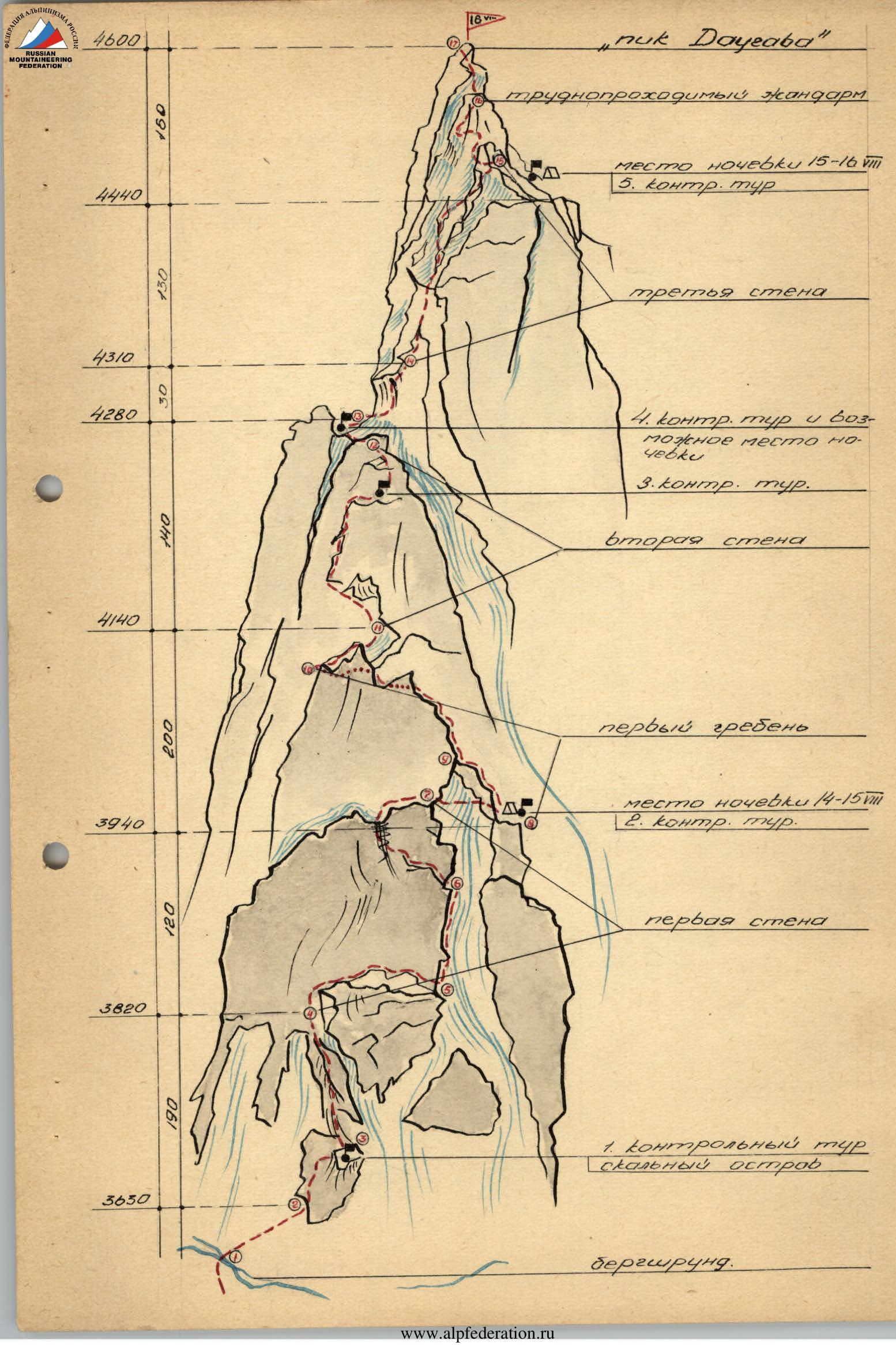 6 rock and 2 ice pitons are hammered in. We exit onto the right (in the direction of travel) rock edge of the couloir. A few meters below, there is a well-protected area from falling rocks where a tent can be set up. By this time, the weather has completely deteriorated. Wet snow is falling, with strong wind and fog. At 17:30, we stop for the night (stage 8). A control cairn is built.
On August 15 at 6:30, we set out on the route. Directly to the bivouac site leads a sharp, steep ridge, with sheer walls dropping off on both sides. The first 60 m are passed relatively easily with circular belaying (stage 9). Then follows 120 m of very difficult climbing. The rocks are monolithic with few holds and cracks. On this section, 4 vertical pitches of about 7 m are encountered, almost without holds. To overcome the last pitch, the lead climber has to be lifted onto their shoulders.
After the fourth pitch, the ridge ends in a 25-meter gendarme. The gendarme is bypassed on the right side in the direction of travel along the wall. The length of the bypass is 50 m. Initially, we move along a narrow ledge, only a few centimeters wide. Then even this ledge disappears. The lead climber descends 5 m and continues movement along an inclined ledge. Then, bypassing the base of the gendarme, we exit onto a col via a crack (stage 10). This section takes 3 hours 10 minutes, with 6 rock and 1 ice piton hammered in. After the gendarme, there is a small col with easy rocks (stage 11).
Beyond the col begins the second wall—the key section of the route. The wall's height is 140–150 m, with a steepness of 80–85°. There are almost no visible holds, and few cracks. Only on the upper part is a faintly expressed internal angle formed. From the start, we have to use ladders and a platform. The first climber, standing on the platform, belays the second. The latter climbs up the rope and stands on the ladders prepared by the lead climber. Since we managed to find sufficient cracks for pitons, only two drillable pitons are used. In the internal angle, there are enough holds, and ladders are not needed. On a small ledge, where there is space for 2 people, a control cairn is built. From the ledge to the top of the wall is 50 m (stage 12). On the second wall, we emerge at 14:35. 26 rock and 2 drillable pitons are hammered in. On the col, it is possible to bivouac (point 13) (stage 14). Then follows 150 m of easy ridge, leading to the third wall.
After passing the ridge, we approach the third wall. The wall's height is 130–140 m. The third part of it is covered in ice, with a steepness of 75–80°. Some areas overhang. To overcome them, we again have to use ladders. A particularly difficult section follows an overhang. Here, rocks are covered in ice. The third wall proves more challenging than expected. Rocks are covered in ice, which holds pitons and steps poorly, making it almost impossible to cut steps. From above, everything is covered in dry, powdery snow that fell the previous night. Only at 20:35 do we ascend onto the ridge (stage 15). On the south side of the ridge, we find a spot to pitch a tent. On the third wall, we work for 6 hours. 3 ice and 26 rock pitons are hammered in. The morning of August 16 is very cold. At 8:30, we set out on the route. The path is blocked by huge boulders, as if hastily and randomly stacked before us. All are very monolithic, smooth, without cracks. For movement, we can only use internal and external angles and chimneys formed at the junctions. In places, the lead climber needs to be lifted. 250 m from the summit, we have to overcome two gendarmes (stage 16). The first is bypassed along the south wall. Then follows a 15-meter rappel. Here begins the final 40 m of difficult climbing on this route, ending 10 m from the summit. At 15:00, the last participant ascends to the summit (stage 17). 40 minutes later, we begin our descent. The descent is very straightforward. Along the rocky ridge, after 60 m, we exit onto the upper plateau of the Korzhenevsky glacier and return to the Talgar alpine camp via the "Surovy" pass.
The route demands good physical and technical preparation from participants, as well as tactical knowledge. Even with its average steepness of 75°, progress is complicated by the fact that the route is hardly ever exposed to sunlight. As a result, there is a lot of ice and, in the upper part, snow. Working on rocks without gloves is almost impossible. Group members believe that the route they have passed fully meets the requirements for classification as the highest category of difficulty—5B.
Overall assessment of the actions of the assault team members during the ascent
Group members have been climbing together for many years, know each other well, and have completed difficult technical ascents together. As a result of systematic, year-round training, participants have acquired excellent physical fitness. They have also mastered special wall climbing techniques.
For acclimatization and training, the group made ascents on wall routes in July of this year:
- on peak Kara-Tau, 5B category of difficulty
- on Talgar via the northwest wall, 5B category of difficulty (Pelevin's route).
Previous physical, technical, and moral preparation allowed the group to pass the route technically cleanly and at a fast pace.
Group coach: (Štrainis) (Imants) Group leader