- Climbing category: combined.
- Climbing area: N. Tien Shan, Trans-Ili Alatau, Talgar base camp.
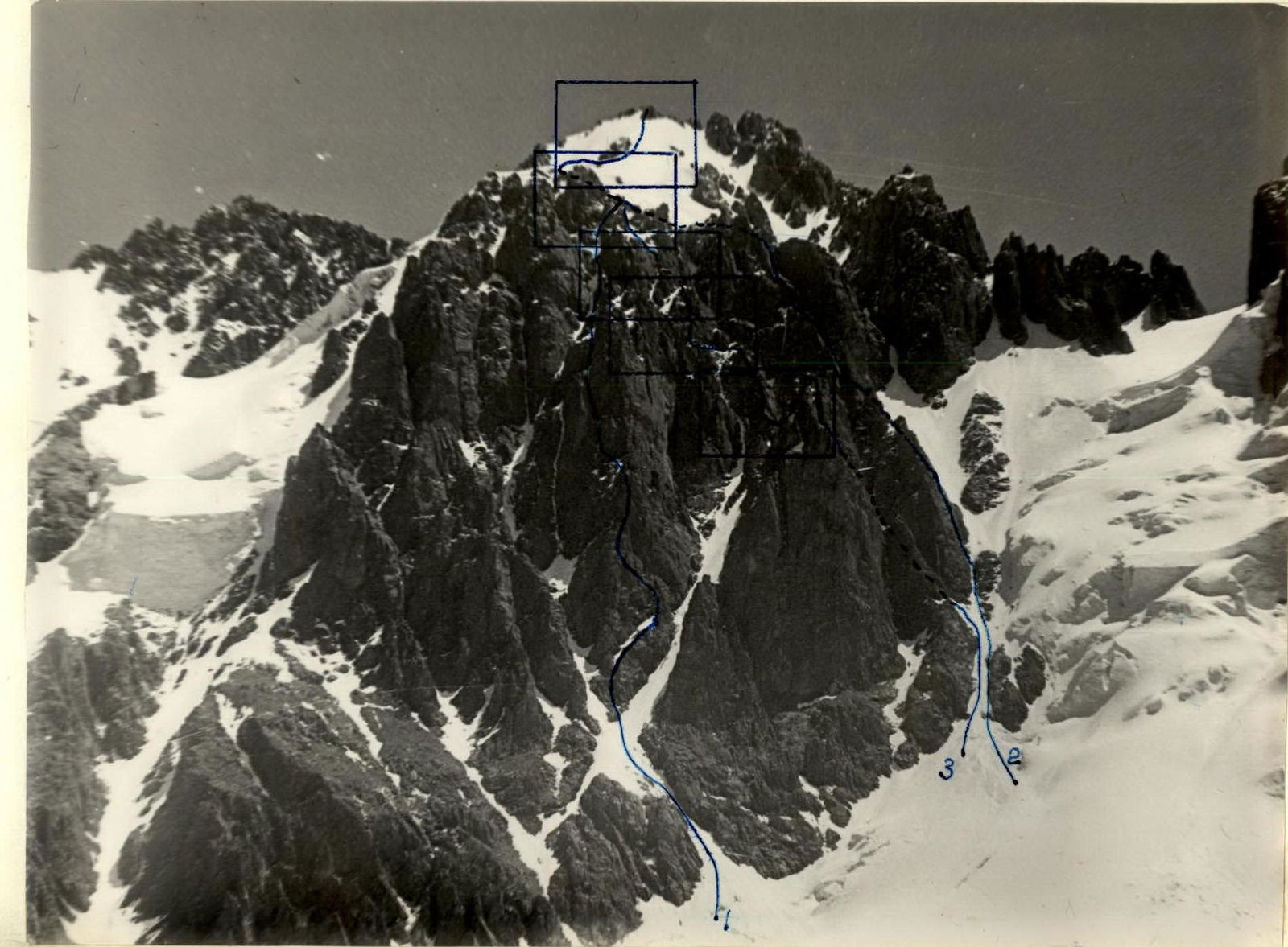
- Peak, its height, climbing route: Yuzhny Talgar, 5020 m, SW wall, center.
- Proposed difficulty category: 5B.
- Route characteristics: height difference 900 m, length of 5th category difficulty sections 200 m, average steepness 45°.
- Pitons driven: for belay, for creating Intermediate Technical Support (I.T.O.).
| rock | 53 | IV |
|---|---|---|
| ice | – | – |
| bolt | – | – |
- Number of travel hours: 14.5.
- Number of overnight stays, their characteristics: 2 overnight stays below the route on the glacier moraine.
- Participants' full names, their qualifications:
Meshkov I.N. Master of Sports Petrashko G.A. Master of Sports
- Team coach: Gonialin V. Date of departure for the route: June 18, 1978, 5:00 AM.
Date of return: June 19, 1978, 3:00 AM.
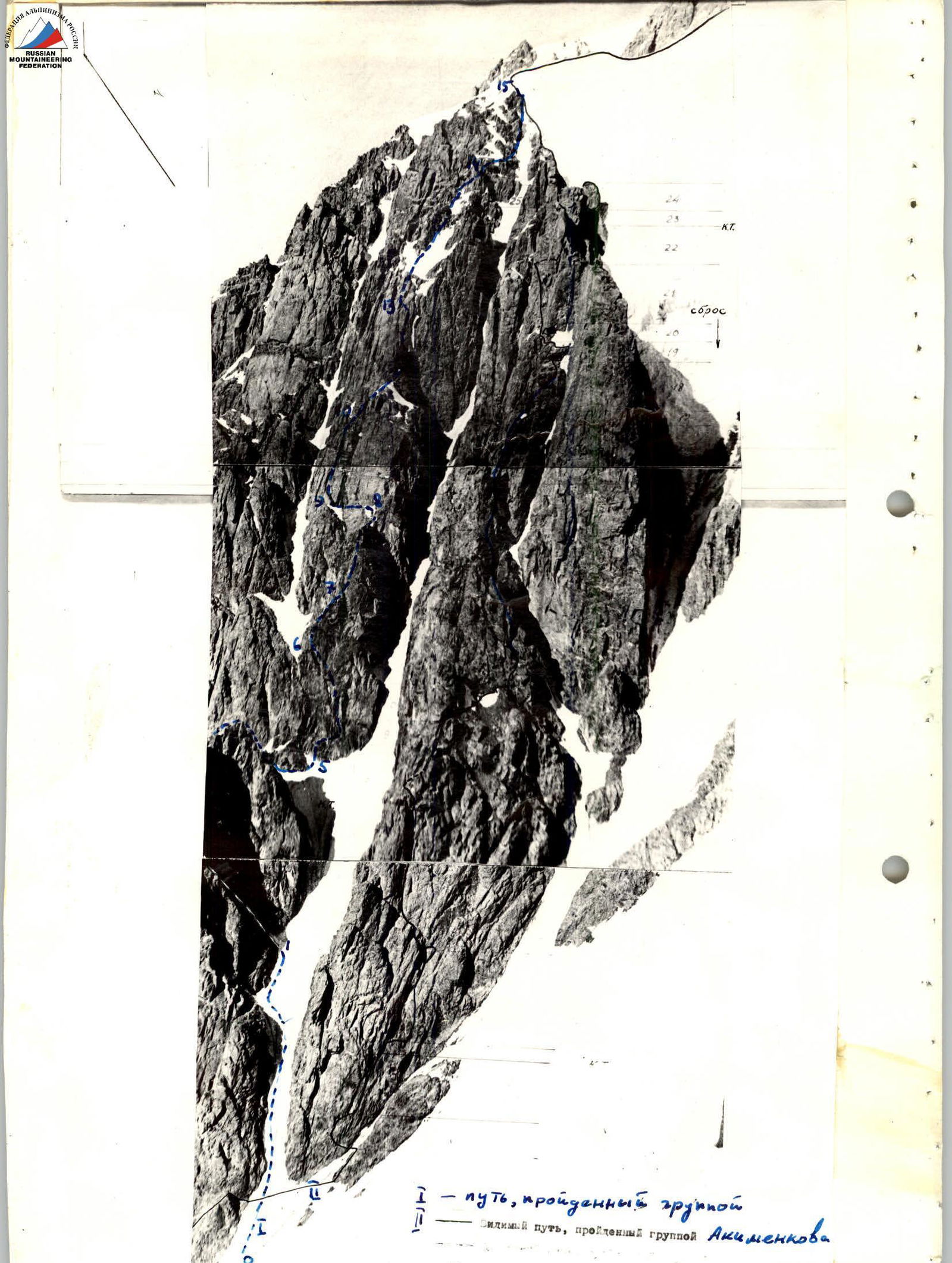
Route description by sections
Section R0–R1
Just below the second rock "island" you need to turn into a snow-ice couloir separating the lower part of the wall with the Akimenkov route from the central part of the wall. On the left remains a large massif of a black gendarme, on the right is the southern wall with the Akimenkov route.
Section length 80 m, snow, firn. Ice is possible at the end of summer. Steepness from 30° to 45°.
On the left, on a well-visible shoulder, there is a control cairn. Another 30 m along the edge of rocks and ice and we approach a small (2–3 m wide) lateral couloir.
Section R1–R2
Up the couloir 40 m. At the top of the couloir is ice. Steepness 40–45°. The couloir narrows and turns into an inner corner. The rocks of the inner corner are difficult at the top, so you should move to the left.
Section length 40 m. Belay via ice axe, outcrops. 2 rock pitons driven.
Section R2–R3
Having overcome a 5 m rock wall, we come out onto a wide rock ridge. Through 50 m of medium-difficulty rocks, we come out onto the steep ridge of a large black gendarme. Rocks are of medium difficulty, but there are many "loose" stones.
Section length 50 m, average steepness 50°. 4 rock pitons driven.
Section R3–R4
Ascent on the right side of the ridge. A 10 m sheer wall, and then a steep inner corner with a steepness of 60°–70°, 50 m long. We come out onto the flat top of the gendarme. Rocks correspond to 4th category difficulty. 6 rock pitons driven.
Section R4–R5
Along the top of the gendarme, you need to walk to the right to the edge of the tower and descend 20 m (loop). From the saddle along the ridge to the base of two separate standing rock blocks. We go around the blocks on the right and descend 30 m through medium-difficulty rocks, and then 20 m along a narrow snowy ridge to a rock massif.
The total length of the section is 80 m. The difficulty of the section corresponds to 4th category difficulty. Belay through outcrops. On the last descent, there are many "loose" stones.
Section R5–R6
From the saddle, ascent to a small shoulder 5 m, then traverse to the right 4 m and ascent along the wall 40 m. At the end of the section, to the left - up 10 m to a small shelf on the northernmost ridge. The lower and middle parts of the section are monolithic. In the upper part, there are several exfoliations. Rock steepness 70°–75°. Section length 55 m. Difficulty corresponds to 5th category difficulty. 7 rock pitons driven for belay.
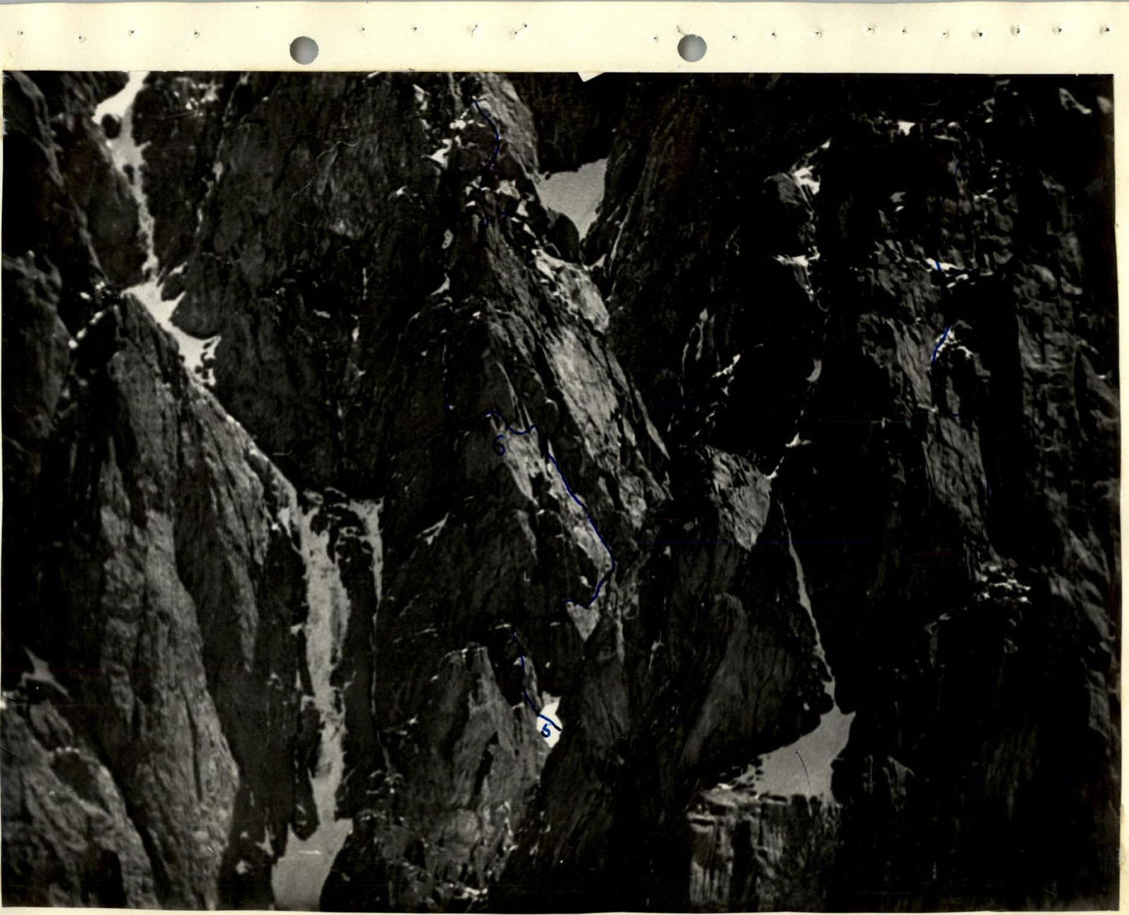
Section R6–R7
From the shelf, 2 m to the left and a little down to the beginning of the inner corner. At first, a sheer section 6 m. Here the inner corner is slightly covered by an overhang. Further, the steepness of the corner is about 75°. Cracks are small. Pitons hold poorly. Two pitons driven for ladders. After exiting the inner corner, up steep rocks. Total section length 40 m. Steepness 70°–75°. 8 pitons driven for belay. Rocks are monolithic, correspond to 5th category difficulty. At the end of the section, there is a convenient place for belay.
Section R7–R8
Well-defined ridge. At the beginning of the section, steepness 60°, after 50 m - 30°. Rocks are monolithic, many cracks, outcrops. Total section length 80 m. Difficulty corresponds to 3rd category difficulty. The ridge leads to the base of the yellow tower.
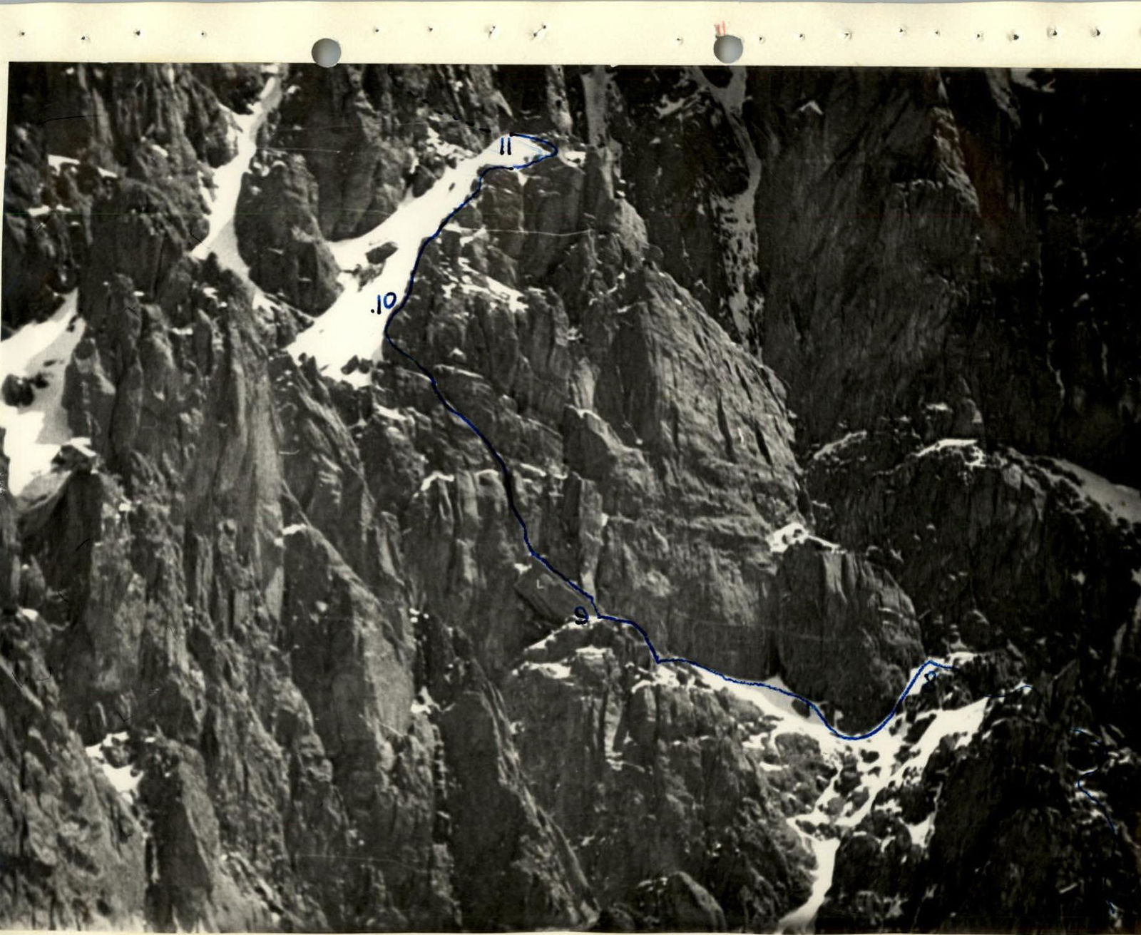
Section R8–R9
Horizontal traverse 50 m to the left along slabs of coarse-grained granite. We come out onto a clearly defined plateau to a huge stone. 2 rock pitons driven for belay.
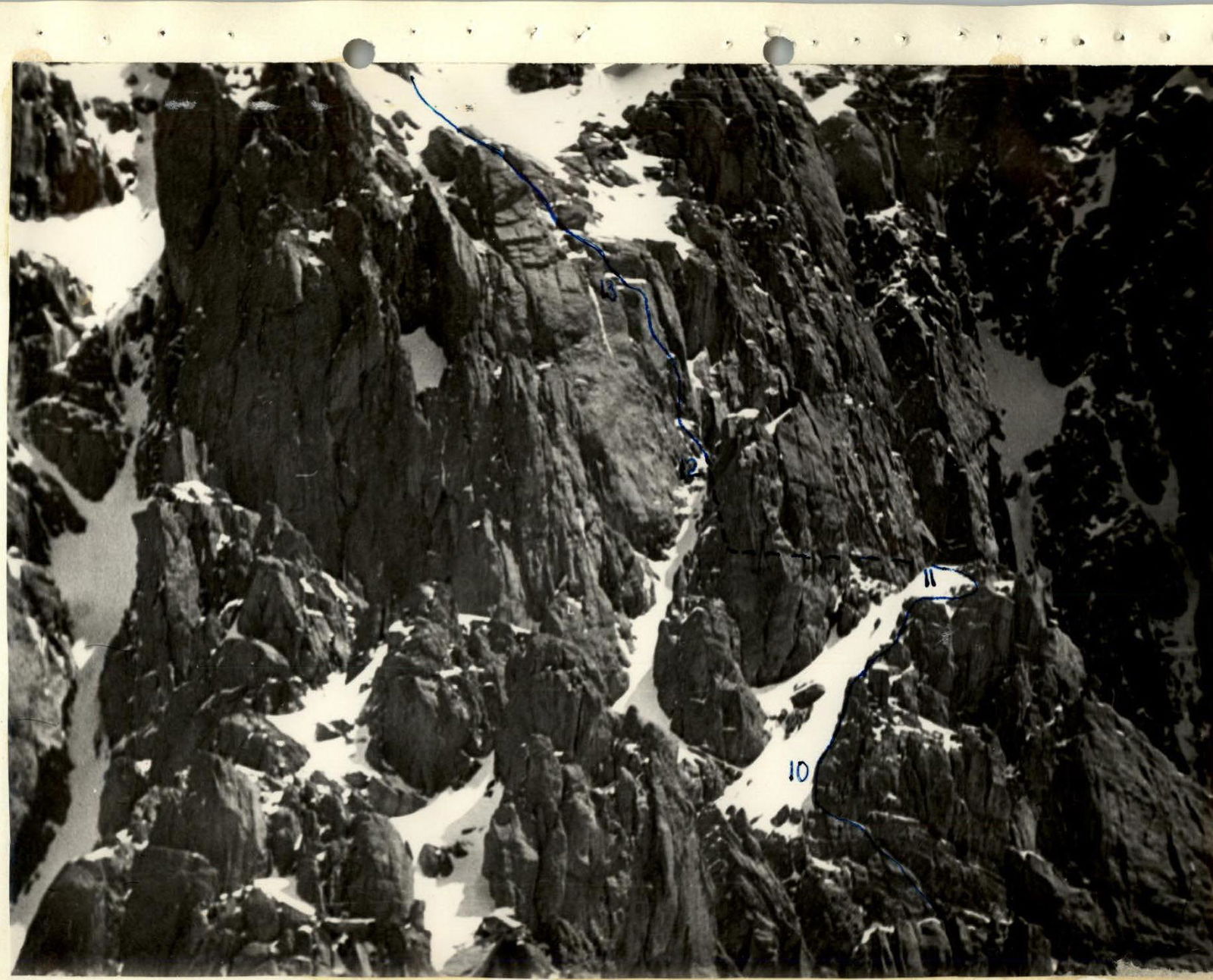
Section R9–R10
We ascend onto the stone and 10 m up along the cleft. Steepness 70°–75°. Leaving a slightly pronounced chimney on the right, we move up to the left 50 m along steep rounded "foreheads". Rocks are monolithic, made of coarse-grained granite. There are few cracks for pitons, they are wide and shallow. Holds are rounded. Total section length 60 m, steepness 70°. 8 rock pitons driven for belay. Difficulty corresponds to 5th category difficulty.
Section R10–R11
Ascent along the ridge 120 m. Steepness 45°. Many outcrops for belay. Rocks are monolithic. Difficulty corresponds to 3rd category difficulty.
Section R11–R12
We descend 3 m to the right and make a horizontal traverse along difficult rocks to the base of the black rock wall. Ascent along the wall 15 m. Rock steepness 75°, but the section is easy to pass. In the upper part, the rocks are composed of "loose" blocks. Section difficulty corresponds to 4th category difficulty. 3 rock pitons driven for belay. At the end of the section, there is an exit to a small saddle under the base of the sheer yellow wall. Here begins the last key section.
Section R12–R13
Sheer wall 40 m with two parallel clefts. Movement begins along the right cleft, then we move to the left one. Rocks are very difficult, smooth. At the end of the section, there is a small shelf with two exfoliations. Rock steepness 80°. 8 pitons driven for belay, 3 cams placed. Ladders were used twice. Rock difficulty - 5th category difficulty.
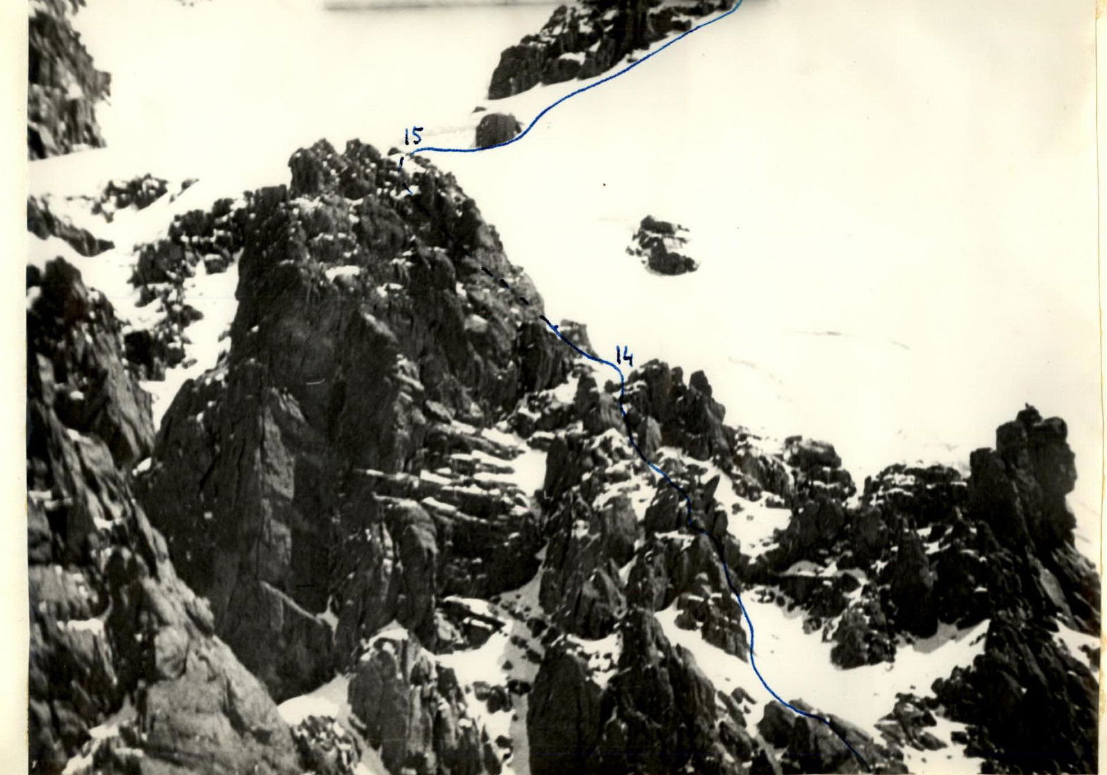
Section R13–R14
After the shelf, exit up 10 m along difficult rocks. Steepness 70°. Further along rocks of 4th category difficulty, with an average steepness of 60°. In some places, there are small snowfields. After 150 m, we come out onto the ridge. Belay through outcrops.
Section R14–R15
Snow-ice sections with many rock "islands". Section length 200 m. Steepness 45°. Difficulty corresponds to 3–4 category difficulty. Belay via ice axe and outcrops. At the end of the section, there is an exit to the shoulder of the Baranovsky route, 4A category difficulty.
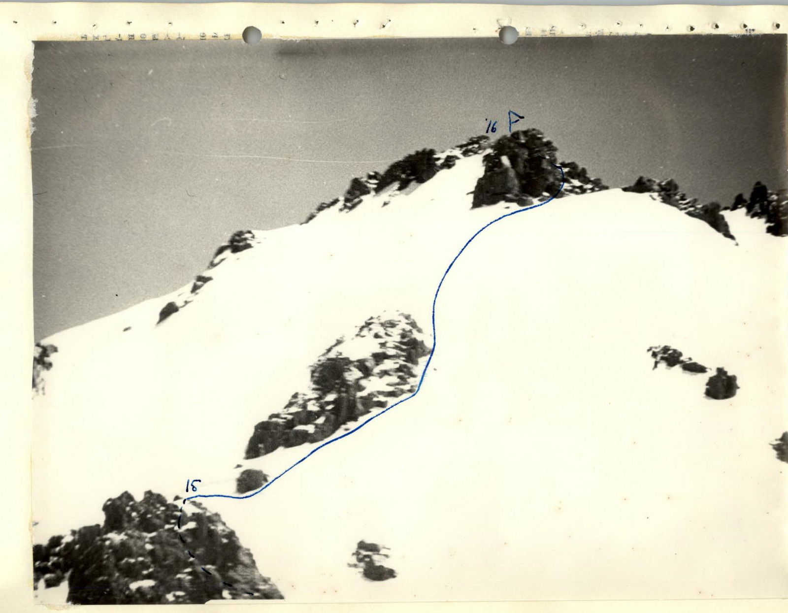
Section R15–R16
Snow-firn fields with a steepness of 30°–40° lead to the summit of Yuzhny Talgar. Section length 400 m.
Descent from the summit via the Baranovsky route, 4A category difficulty, does not present any particular difficulties.
Ascent schedule
- 5:00 AM - departure from the overnight stay at the Yuzhny Talgar glacier
- 7:00 AM - start of the route
- 9:00 AM - exit to section R5–R6
- 6:00 PM - exit to the beginning of section R13–R14
- 8:00 PM - exit to the beginning of section R15–R16
- 9:30 PM - exit to the summit of Yuzhny Talgar
- 3:00 AM - return to the overnight stay
The duo spent 14.5 hours of continuous work directly on the route. Excellent knowledge of the area allowed the group to carry out a nighttime descent.