REPORT on the first ascent via the North-North-West ridge
Group of instructors from TALGAR alpine camp
| Ponkratov | E. I. | 1st category, leader |
| Zotov | A. V. | 2nd category, participant |
| Shabrukov | V. I. | 1st category — « — » |
| Gerost | V. P. | 2nd category — « — » |
| Zhukov | N. A. | 2nd category — « — » |
Alma-Ata, 1977

Fig. 1. Map of the area around peak Sportivnaya — route of the first ascent.
Peak Sportivnaya
via the North-North-West ridge. Peak Sportivnaya is located in a lateral ridge branching off from the Trans-Ili Alatau ridge, west of the peak Metallurg massif, in the area of peak Kopr. To the north-west of peak Metallurg, the Ala-Tas ridge branches off. Between these two ridges lies the Ozerny glacier. From peak Sportivnaya, two ridges branch off in the north-north-west and north-west directions, with the Sportivny glacier lying between them.
There are three categorized routes to peak Sportivnaya:
- from Ozerny glacier via a couloir — Category 1B difficulty
- from Kzyl-Tyuz pass via the 10-3 ridge — Category 2A difficulty
- via the North-West slope — Category 2B difficulty (from Sportivny glacier)
The described route is laid out along the north-north-west ridge, separating the Ozerny and Sportivny glaciers (Fig. 1).
From the camp, follow the trail, past the training rocks, to the right (orographically) side of Ozerny glacier, to its lateral moraine under the slopes of peak Kolokolnikova in the Ala-Tas ridge. From here, the entire route is visible. A good location for the initial bivouac. From the camp — 2 hours.
From the bivouac site, cross the glacier in the direction of a wide scree-filled couloir in the North-North-West ridge of peak Sportivnaya. Ascend through the center of the couloir to the lowering in the ridge. On the col — 1st control point. From the bivouac — 1 hour. Here begins the route.
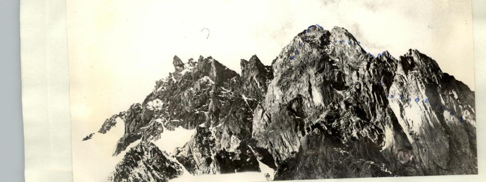
Before the sheer rock wall lies a huge rock island in the snow-ice slope. In the wall, to the left and right, are two steep couloirs. To the right, the rocks are heavily damaged, and on the snow, traces of falling rocks are visible. The left couloir separates a steep, sheer tower (1st gendarme) from the ridge. The rocks are solid (Fig. 2, 3).
Section R0–R1 (Fig. 2). Start on the rock island. The rocks are damaged. Proceed to the left col, separating the island from the wall. The ice col, 12–15 m, with an incline of 40° and embedded stones, is overcome directly. Emerging onto the rocks, hammer in a piton.
Section R1–R2 (Fig. 2, 3). Upon emerging onto the rocks, ascend 4 m to the left. Then traverse left along the right wall of the left couloir. In the upper part, enter the couloir. Exit the couloir via an internal corner, slightly overhanging (4 m) (Fig. 4, 5, 6), leading to scree shelves and further to the col after the first gendarme. Piton belay, use of ropes.
Section R2–R3 (Fig. 1, 7). Further movement is along the left side of the ridge. From the col, via a 15 m internal corner, then transition left onto a 60–70° slab and from it right upwards to the shoulder of the second gendarme. Piton belay, rocks are solid.
Section R3–R4 (Fig. 1, 7). 10 m along the ridge and enter a 20 m internal corner, leading to the col before the second gendarme (Fig. 8). Piton belay, through ledges, organization of ropes.
From the col:
- descend left down 5 m;
- approach a 5 m sheer wall;
- pass the wall;
- reach the summit of the second gendarme.
2nd control point.
Section R4–R5 (Fig. 1, 7). Further descent into the lowering between the 2nd and 3rd gendarmes. Along the ridge (simultaneous movement) approach under the 3rd gendarme. The gendarme is bypassed on the left via shelves to an ice couloir and along the edge of ice and rocks — exit to the col between the 3rd and 4th gendarmes (a large triangular wall — "bastion"). 3rd control point. Time from the start of the route — 3 hours 30 minutes.
Section R5–R6. The wall is passed on the right via shelves in the direction of a large steep rock gully, separating the "bastion" and the 5th gendarme. Movement along the shelves right upwards (Fig. 9). Alternate movement, with piton belay and through ledges.
Section R6–R7. Then up the gully to the left. In places, wet rocks and ice formations. In the upper part, a 10 m wall (Fig. 10). Piton belay.
Section R7–R8 (Fig. 11). 30 m further, not reaching 15 m to the col between the "bastion" and the 5th gendarme, enter a 20 m internal corner with a plug at the top (Fig. 12). Passed in bridging. Before exiting onto the plug — a piton! Further, the corner (Fig. 13).
Section R8–R9. The corner leads to the ridge. Simultaneous movement, rocks are damaged. Along the ridge — exit to the summit of the 5th gendarme.
Section R9–R10. From the summit of the gendarme, descend left into a depression via 40 m scree shelves.
Caution! The shelves are heavily damaged.
Section R10–R11. From the depression, a rock ascent. Move right upwards via a not clearly defined corner to a horizontal shelf with a ledge. The exit is complex (Fig. 4).
Attention! There are "live" rocks. Between the ledge and the wall, the entire group can be accommodated. Then traverse along the wall to the right and exit to the boundary of rocks and ice.
Section R11–R12. Along the boundary of rocks and ice, ascend 40 m. Then to the right, crossing the snow-ice slope to a rock island, via which ascend to the rock ridge, leading to the ice "sickle".
Section R12–R13. Movement along the ridge of the "sickle" with piton belay on crampons. Veering left, after 120 m, approach a rock island, bypassing it on the right via the snow-ice slope, exit to the next rock island.
Section R13–R14, Section R14–R15. Further movement along two arcuate snow-ice ridges and exit to the summit. From the 3rd control point — 4 hours 30 minutes.
Descent from the summit via a wide scree-filled couloir onto the Kopr glacier. Further along its right side to the camp.
Recommendations for climbers
- Number of participants — 6 people.
- Departure from bivouac — not later than 6:00.
- Equipment for the group: a) main rope — 3 × 40 m; b) crampons — 3 pairs; c) rock pitons — 8 pcs; d) ice pitons — 4 pcs; e) hammers — 2 pcs.
Table of characteristics of the ascent route
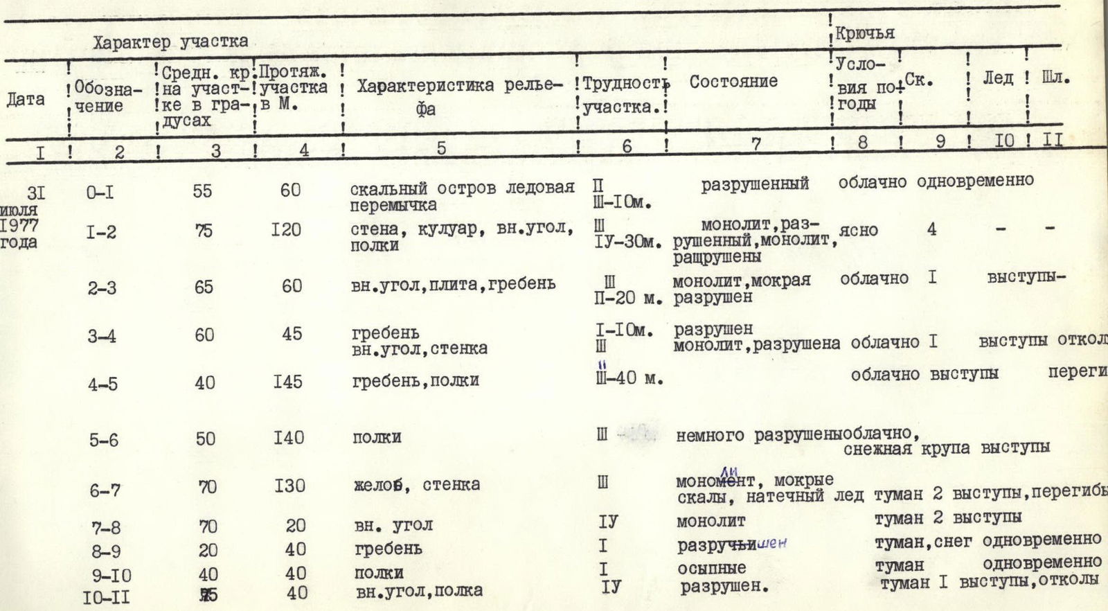
| Date | Designation | Average steepness, ° | Length, m | Characteristic of relief | Difficulty of section | Condition | Pitons | Conditions by years | Rocks | Ice | Scree |
|---|---|---|---|---|---|---|---|---|---|---|---|
| July 31, 1977 | R0–R1 | 55 | 60 | rock island, ice col | II–10 m | damaged | cloudy | simultaneous | |||
| R1–R2 | 75 | 120 | wall, couloir, internal corner, shelves | IV–30 m | monolith, damaged | 4 | clear | ||||
| R2–R3 | 65 | 60 | internal corner, slab, ridge | II–20 m | monolith, wet, damaged | cloudy | 1 | ledges | |||
| R3–R4 | 60 | 45 | ridge, internal corner, wall | I–10 m | monolith, damaged | cloudy | 1 | ledges, ledge | |||
| R4–R5 | 40 | 145 | ridge, shelves | III–40 m | cloudy, ledges, bends | ||||||
| R5–R6 | 50 | 140 | shelves | III | slightly damaged, snow grains, ledges | cloudy | |||||
| R6–R7 | 70 | 130 | gully, wall | III | monolith, wet rocks, ice formations | fog | 2 | ledges, bends | |||
| R7–R8 | 70 | 20 | internal corner | IV | monolith | fog | 2 | ledges | |||
| R8–R9 | 20 | 40 | ridge | I | damaged | fog | snow | simultaneous | |||
| R9–R10 | 40 | 40 | shelves | I | scree | fog | simultaneous | ||||
| R10–R11 | 45 | 40 | internal corner, shelf | IV | damaged | fog | 1 | ledges, ledges |
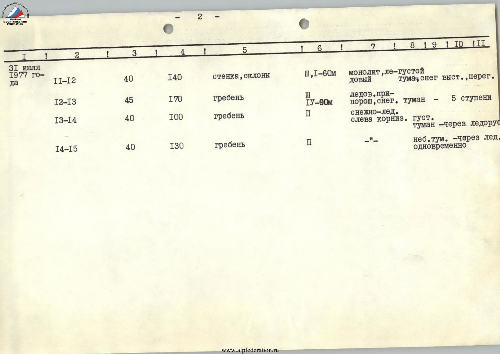
| Date | Designation | Average steepness, ° | Length, m | Characteristic of relief | Difficulty of section | Condition | Pitons | Conditions by years | Rocks | Ice | Scree |
|---|---|---|---|---|---|---|---|---|---|---|---|
| R11–R12 | 40 | 140 | wall, slopes | III, I–60 m | monolith, ice | thick fog | snow | ledges, bends | |||
| R12–R13 | 45 | 170 | ridge | IV–80 m | ice dusted with snow | fog – 5 tiers | |||||
| R13–R14 | 40 | 100 | ridge | II | snow-ice, left cornice, thick | fog – through ice fall | |||||
| R14–R15 | 40 | 130 | ridge | II | slight fog – through ice simultaneously |
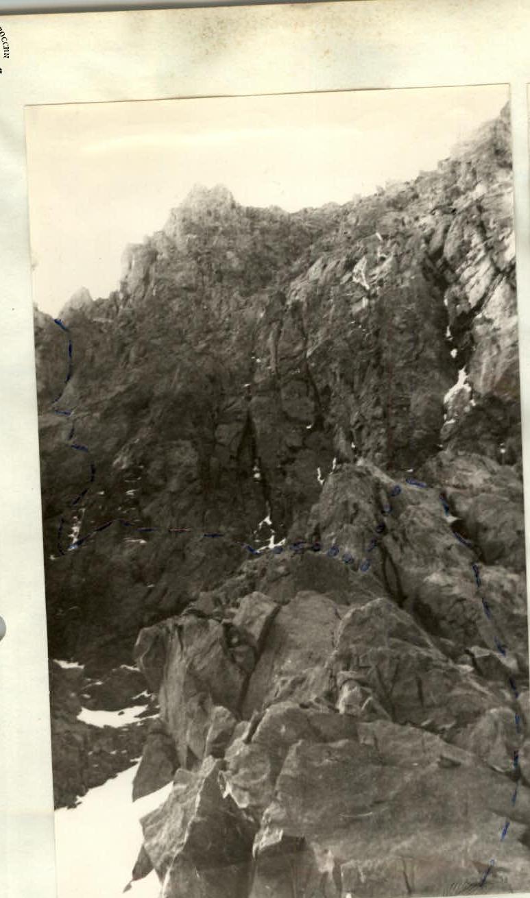
Fig. 2. Sections R0–R1 and R1–R2.

Fig. 4. On section R1–R2. Right wall of the couloir.
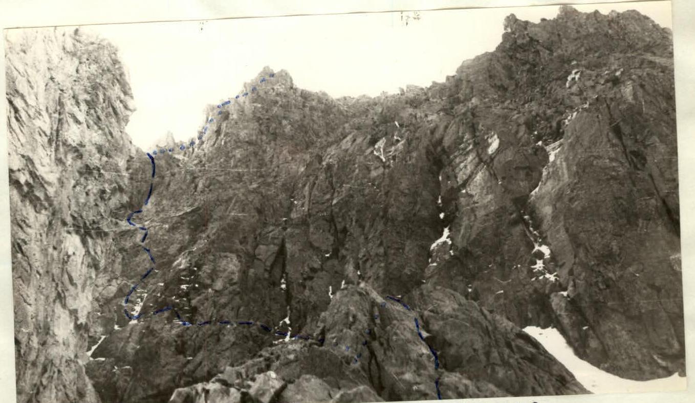
Fig. 3. Start of the route, sections R0–R1, R1–R2.
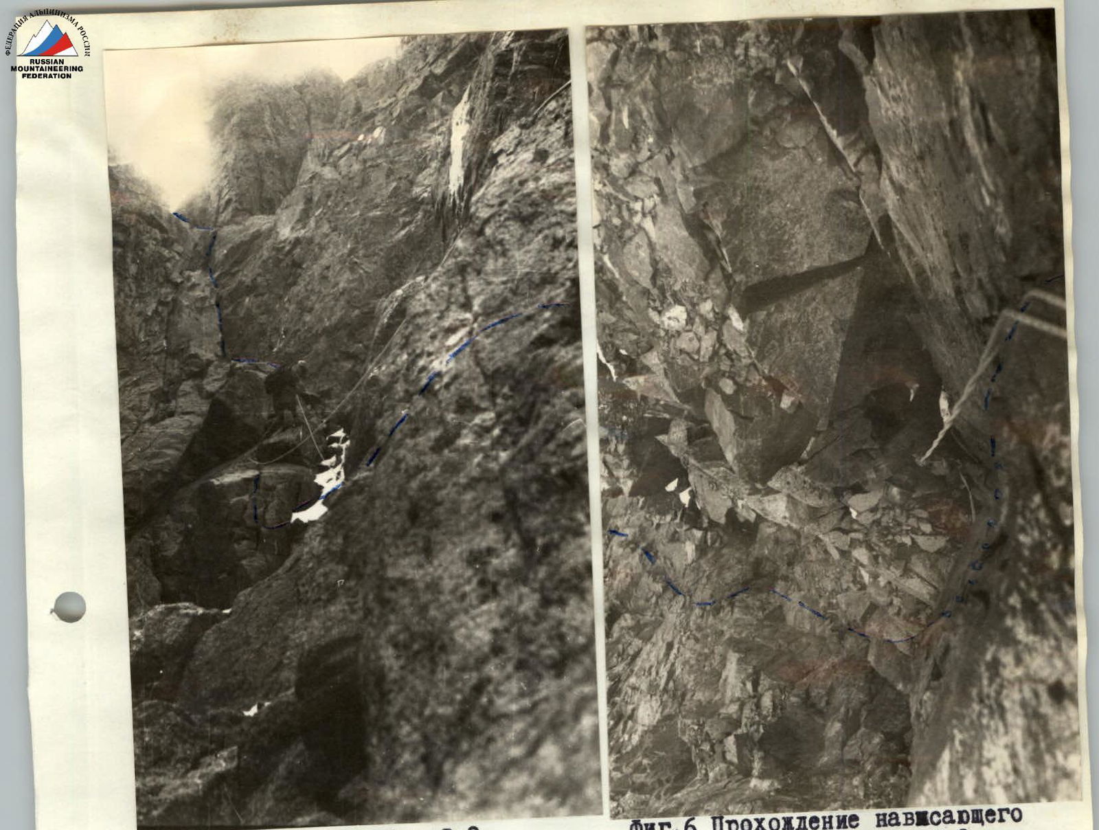
Fig. 6. Passage of the overhanging corner on section R1–R2.