Description
Traversing Peak Kommunizm (Komosomola) with ascent via the Northeast ridge from the Kommunar (Komosomolets) Glacier and descent to the South onto the Bogdanovich Glacier.
In winter conditions, the route corresponds to category 5A difficulty.
The traverse of Peak Kommunizm by this route begins from the Kommunar Glacier, which descends in a NE direction from the peak.
The approach to the start of the traverse at the lower part of the Kommunar Glacier can be made via different paths:
- From the valley of the Leviy Talgar River along the stream bed and moraines of the Kommunar Glacier.
- Through the Chkalov Pass, situated between the peaks Chkalov and Fizkulturalnik.
- Via a pass in the same spur, through the saddle between Peak Kommunizm and Peak Fizkulturalnik.
The group that compiled the description took the second option, as this route is shorter and in winter conditions is the safest.
After reaching the Kommunar Glacier, one should rest. The bivouac is usually set up opposite the couloir descending from the NE ridge to the glacier, slightly north of the ridge's peak known as "Snezhnoe plato" (Snowy Plateau). Choosing a bivouac site is not difficult: there are moraines, scree, and in summer, water.
The couloir's exit to the Kommunar Glacier resembles an avalanche cone, with a slope of about 40° at its lower part. The right (in the direction of travel) side of the couloir is a rock wall. The left side initially drops steeply with scree, and higher up, there are rocks. At the beginning of the ascent, one should stay on the left side, as rockfall is possible from the right. The couloir is usually snow-ice, and only by the end of summer does it completely clear of snow. In winter conditions, overcoming the couloir is complicated; the ice is often exposed until February-March, very smooth and dense, and if covered with snow, it does not ease but complicates the ascent. Usually, in winter, the snow is very powdery, and despite a 30-40 cm layer, it does not provide sufficient support, necessitating the use of crampons. While the danger of rockfall is almost absent in winter, the risk of avalanches significantly increases.
During our ascent through the couloir, we climbed to the confluence of two couloir streams. The slope here increases significantly (photo № 2), and the width of the couloir increases to 70-80 m. Due to the high avalanche risk, we moved to the right (in the direction of travel) under the rocks. Moving along the edge of snow and rocks, and in places on rocks with piton belays, we reached the upper part of the couloir. From here, after a short traverse to the left and upwards, we reached the ridge near the "Snezhnoe plato" peak.
The ascent along the ridge to the "Snezhnoe plato" peak is not particularly difficult. The path from the foot of the couloir to the "Snezhnoe plato" peak took our group 11 hours in summer. This path takes 4-5 hours.
The descent from the "Snezhnoe plato" peak to the saddle goes along a gentle snow slope; on the saddle itself, there are rocks of medium difficulty. The first and second gendarmes are bypassed on the right along the rocks. When passing this section, one should be cautious of the rocks' instability and the abundance of debris. Overcoming this section is complicated if the debris is covered with powdery snow (photo 3).
The further path goes along the ridge through rocks of medium difficulty, and in places, difficult. The path from the saddle to the 3880 m peak in summer conditions takes about 3 hours; our group took 6.5 hours in winter.
The descent from the 3880 m peak goes along inclined slabs. One should stay on the right side of the ridge without going onto it. The descent in summer takes 30-40 minutes; in winter, the descent took just over an hour. From the saddle before the 3910 m peak, the route continues as follows:
From the saddle, 4-5 meters further, there is a ledge where two people can stand and organize a piton belay. Then, along a heavily destroyed wall with an 80-85° slope, for 12-15 meters.
Continuation
This section must be traversed with mandatory piton belay, as it is very difficult and prone to rockfall in summer. Movement here in winter is complicated by the presence of ice on the rocks.
After the wall, along a ledge, we move to the left in the direction of travel, where 2-3 people can stand. Further, through a small couloir, sticking to the rocks on the right side, we reach a small platform. From here, along a 15-18 m wall, we reach a snow-ice section of 10-12 m. From it, we reach a 2 m high rock wall where a piton must be hammered, as the movement goes to the left.
7-8 meters from the piton, another wall is encountered, where piton belay is also necessary. After overcoming this wall, 6-8 meters further, we reach the ridge.
The entire section from the saddle to the ridge goes through very brittle rocks with a slope of 80-90°. Maximum attention to belay, path selection, and choice of ledges and cracks is necessary. From the ridge to the peak, the path goes through rocks of medium difficulty (2 ropes), after which we reach the 3910 m peak.
The descent from the 3910 m peak goes along rocks of medium difficulty (4 ropes) and leads to the saddle before a small gendarme. This gendarme is bypassed on the left, then a descent "sitting on a rope" for 6-8 m, and along a couloir (20 meters) that leads to a snow slope. From the snow slope, we descend one rope length down, then turn right, bypass the gendarme (3 ropes), and exit into the couloir. The couloir is completely snowy in winter, with ice under the snow in its upper part.
We ascend the couloir to the saddle between the 3910 m peak and the ridge leading to Peak Kommunizm.
The ascent from the saddle goes along a snowy ridge, the upper part of which turns into rocks of medium difficulty. After the rocks, there is a slight descent, and along the snowy ridge, we reach under a wall (photo 4). In the lower part of the wall: 3-4 m of very difficult rocks, then a section of medium difficulty about 4 ropes long.
Further, the path goes again along a snowy ridge leading to rocks of medium difficulty. After these rocks, again along a snowy ridge with a slope of up to 50°, we reach the trident of the 4089 m peak.
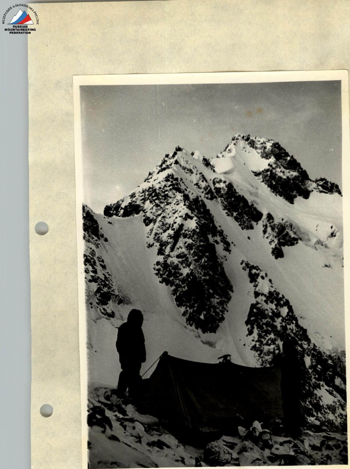
Photo 1
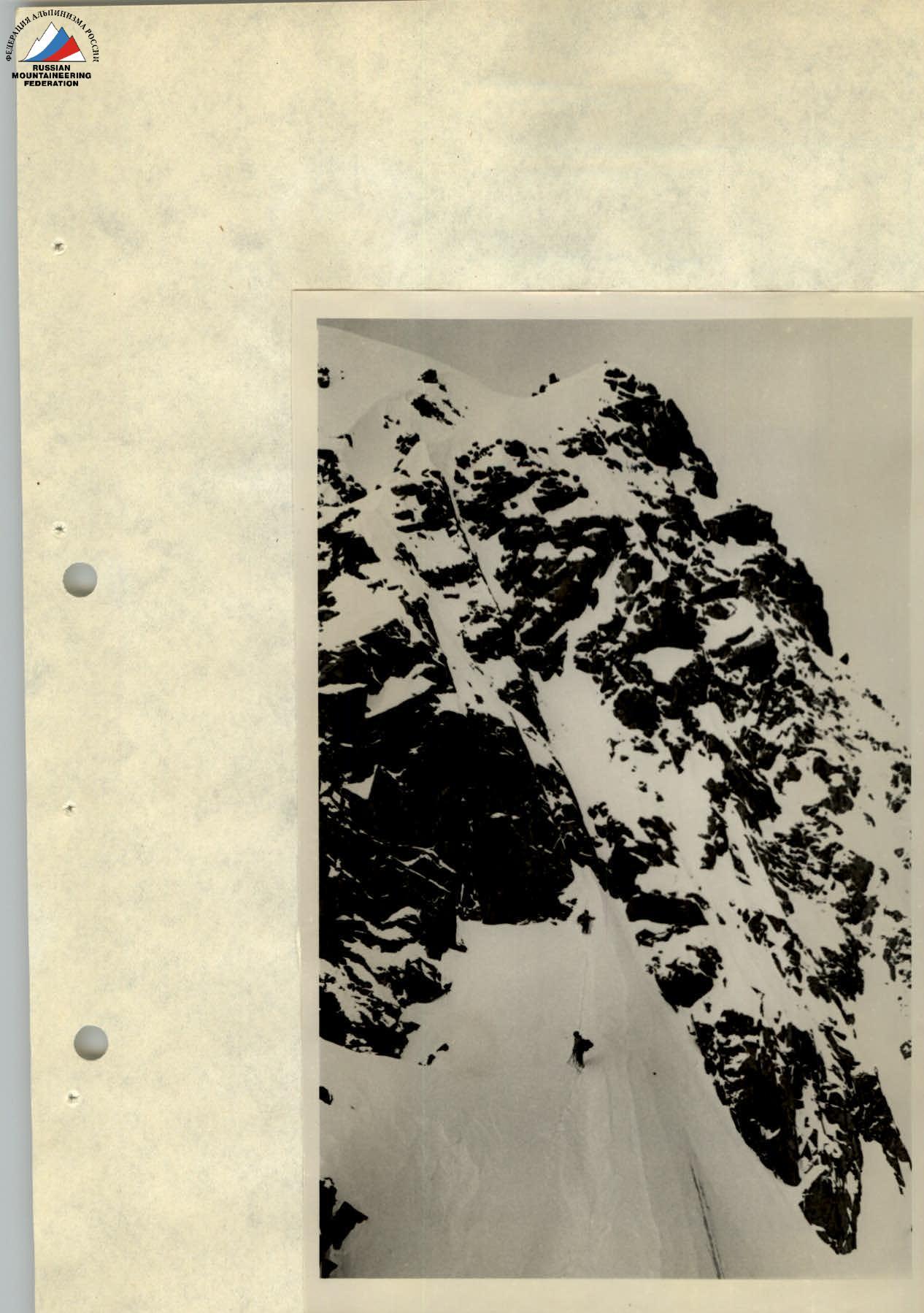
Photo 4 (2)
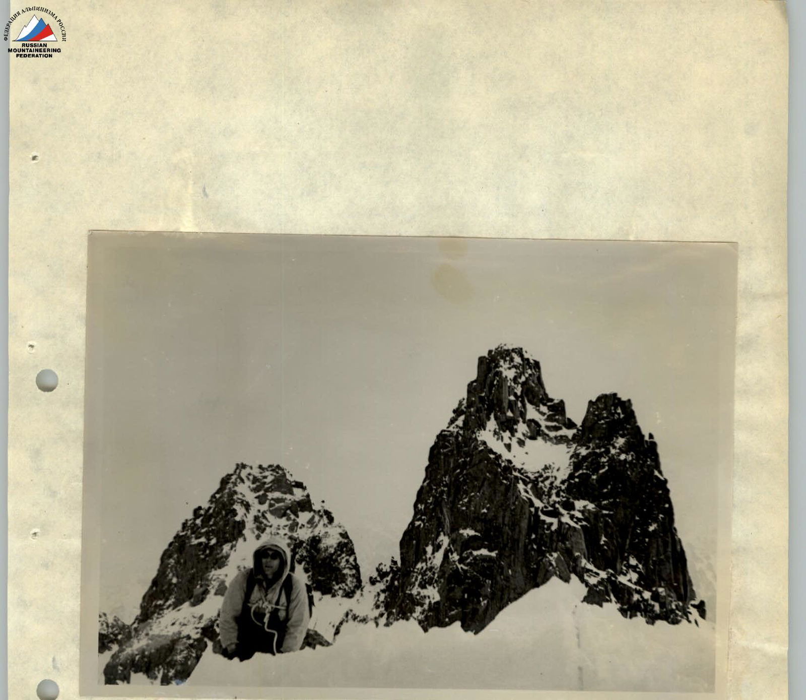 Photo ? (3). From the 4089 m peak, we go along the snowy ridge to Peak Kommunizm. Not reaching the base of the peak along the ridge, we need to move left for 2 ropes, then:
- along difficult rocks for 30-40 m;
- after the rocks, traversing left and upwards, we reach Peak Kommunizm.
Descent via route 20yak.tr. to the Kommunizm Pass and then to the Bogdanovich Glacier.
Conclusion
In winter conditions, traversing the NE ridge of Peak Kommunizm is undoubtedly more complex. It requires climbers to be in good physical condition. The passage of certain sections, especially ice and rock sections, is much more complicated and requires significantly more time and attention during movement (photos 3, 4, 7, 8, 9).
If in summer the ridge is traversed with one overnight stay, in winter, 3-4 overnight stays are necessary. (photos 1, 10, 11)
When overcoming the NE ridge: The route, not counting the approaches and return, took our group 36 working hours.
According to the conclusion of the leaders and participants of the groups that have passed this route, traversing the NE ridge of Peak Kommunizm corresponds to category 5A difficulty.
Description compiled by — M. Kulemin Participants: Kolichim, Bir Studenin, Port Briquette.
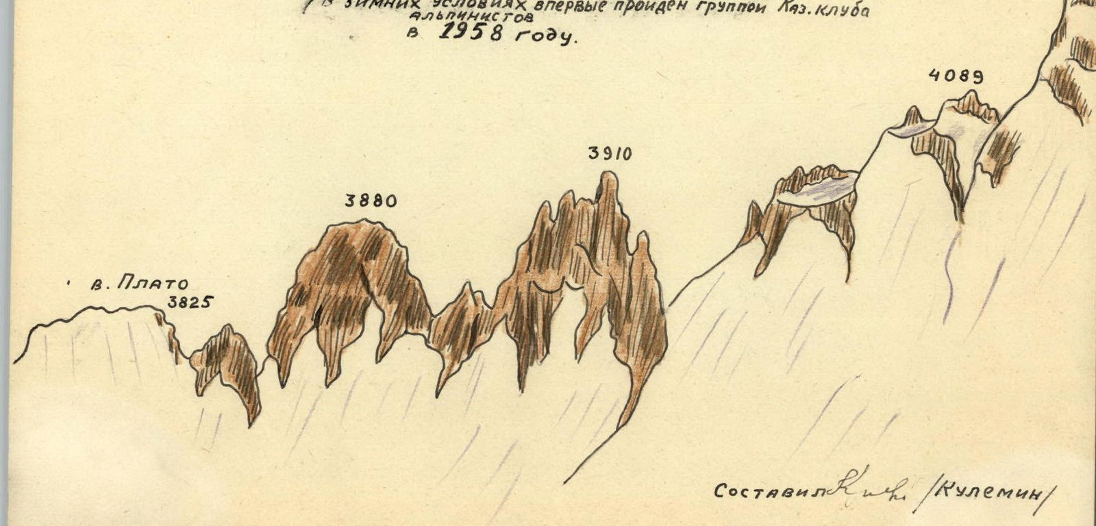
 The traverse path of Peak Kommunizm via the 5A category route along the NE ridge (first traversed in winter conditions by a group of the Kaz. climbing club in 1958).