Ascent Log
TO THE SUMMIT OF KLYSHTAU VIA THE NORTH-WEST RIDGE
- Ascent category — rock climbing.
- Ascent region — Trans-Ili Alatau.
- Summit — Klyishtau via the North-West ridge (4250 m).
- Expected difficulty category — 4–5.
- Route description: height difference — 800 m. average steepness — 63° (difficult sections). Length of sections: R1 — 70 m, R14 — 40 m, R15 — 400 m, R2 — 20 m, R3 — 60 m, R4 — 10 m, R16 — 30 m, R17 — 100 m, R5 — 60 m, R6 — 40 m, R7 — 25 m, R18 — 50 m, R8 — 150 m, R9 — 45 m, R10 — 50 m, R11 — 100 m, R12 — 100 m, R13 — 300 m.
- Number of pitons: for belaying, for creating artificial anchors. rock — 65, ice — 3, bolt — .
- Number of travel hours — 20.
- Number of overnight stays — 1.
- Surname, first name, patronymic — Filatov S.A., 1st sports category — leader; Bylin N.G., 1st sports category; Izmailov V.N., 1st sports category; Pashkov P.M., 1st sports category; Zyryanov V.N., 1st sports category.
- Team coach — Kurgin S.N.
- Date of departure on the route — July 12, 1978, and return — July 13, 1978.
| Date | Section | Avg. steepness (°) | Length (m) | Terrain type | Difficulty | Condition | Weather conditions | Rock pitons | Ice pitons | Bolt pitons |
|---|---|---|---|---|---|---|---|---|---|---|
| R0–R1 | 50 | 70 | Firn, ice | 3 | 3 | |||||
| R1–R2 | 60 | 20 | Rocks, ice | 3 | Unstable | 3 | ||||
| R2–R3 | 60 | 60 | Couloir | 4 | Ice coating | 4 | ||||
| R3–R4 | 50 | 10 | Medium rocks | 3 | Unstable slabs | 3 | ||||
| R4–R5 | 20 | 60 | -«-» | 3 | -«-» | |||||
| R5–R6 | 60 | 40 | Rocks | 4 | Loose | 7 | ||||
| R6–R7 | 20 | 25 | Medium complexity | 3 | Unstable | |||||
| R7–R8 | 30 | 150 | Complex rocks | 4 | Small ledges | 8 | ||||
| R8–R9 | 40 | 45 | Loose rocks | 3 | Unstable with ice | 8 | ||||
| R9–R10 | 50 | 50 | Couloir | 4 | Rocks, ice | 5 | ||||
| R10–R11 | 70 | 100 | Couloir | 4 | -«-» | 10 | ||||
| R11–R12 | 70 | 100 | Wall | 5 | Unstable rocks | 10 | ||||
| R12–R13 | 30 | 300 | Medium rocks | 3 | -«-» | |||||
| R13–R14 | 75 | 40 | Complex rocks | 5 | Monolith | 10 | ||||
| R14–R15 | 20 | 400 | Firn slope | 2 | ||||||
| R15–R16 | 70 | 30 | Steep firn slope | 3 | 1 | |||||
| R16–R17 | 20 | 100 | -«-» | 2 | ||||||
| R17–R18 | 50 | 50 | 4 | Unstable rocks | 5 |
Route Description
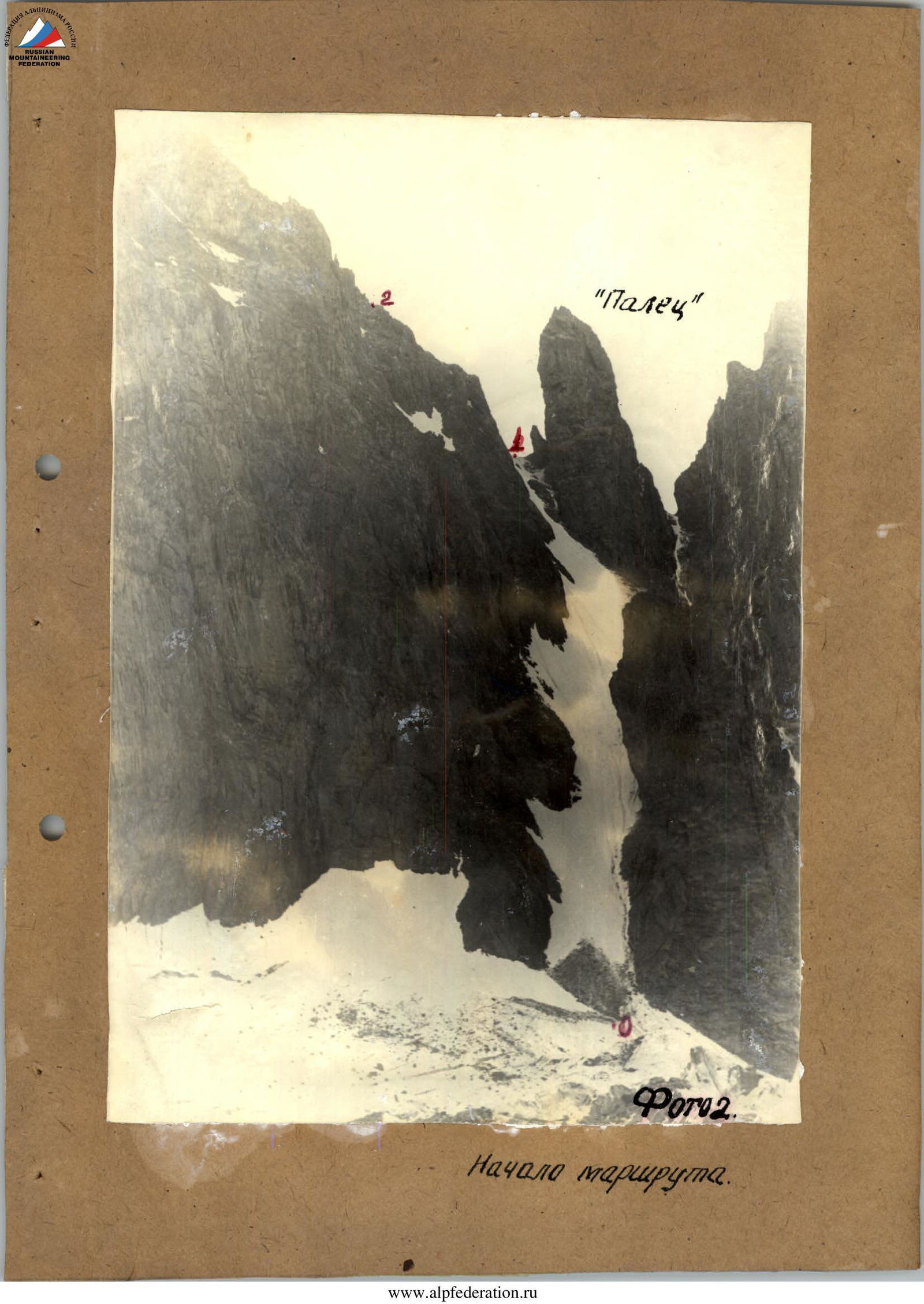
From the "Edelweiss meadow" campsite to the terminal moraine of the North Talgar glacier, then across the center of the glacier to a characteristic "finger" located on the ridge. Travel time from the campsite to the base of the couloir is 1.5–2 hours. The ascent to the ridge is on the left side of the "finger" via a steep snow-ice couloir (50°). Rockfall hazard! Travel in rope teams. Photo 2.
On the ridge, there is a cairn. From the ridge, the 1st pinnacle "Tower" begins: a triangular 150-meter rock formation. It is bypassed on the right via rock ledges. Piton belay (7–8 pitons).
Then, proceed to the ice couloir and ascend it. Steepness up to 60°. Then, transition to the second couloir, covered with ice coating (60–70 m, steepness 60°). Piton belay. Photo 1.
Reach the middle of the counterfort, then start ascending to the pinnacle along the ridge. Rockfall hazard!
Ascend slabs with a steepness of 50–60°, which have many "loose" rocks, to a ledge under a chimney where the group can gather. From here, ascend to the summit of the "Tower" pinnacle via moderately difficult, unstable rocks.
Descend from the pinnacle initially via the ascent route to the first ledge, then via ledges to the right and down, and after some time, reach the ridge behind the "Tower". The total time required to bypass the "Tower" is 3–4 hours.
The 2nd pinnacle is ascended directly, initially along the junction of rocks and snow, then via rocks. Piton belay (7–8 pitons). Reach the summit to a cairn. Time — 1–2 hours. Photo 1.
Photo 1. Then, proceed along the unstable rock ridge with alternating belay. After 15 m, the path is blocked by a large stone pillar. It is overcome via a "window" on the left — a half-chimney. After 15 minutes, approach the 4th pinnacle — "Cockerel's Crest". This is a sharp, jagged ridge with sheer walls. It can only be bypassed on the right via barely noticeable but firm ledges. 5–6 pitons are required. On the south side, there is a cairn. The bypass takes 1 hour. Photo 1.
Photo 1. The next pinnacle is "Castle". It is impossible to ascend it directly. Therefore, after passing "Cockerel's Crest", descend into the ice couloir between "Cockerel" and "Castle". Access the couloir via a loose rock wall. After 45 m, another couloir, snow-ice, merges with this couloir, with rock slabs at the top. Its length is about 50 m, steepness 40–50°. Photo 1.
Ascend this couloir with piton belay on the left side to a terrace on the counterfort of "Castle". Then, proceed along the couloir for 100 m under the rock wall.
Ascend the wall via an inner corner, then in the direction of a clearly visible characteristic rock "Quill". On the summit of "Castle", there is a cairn.
Continue along the ridge to a small plateau. From here, descend to a ridge. Behind the ridge is the 5th pinnacle — "Knife". It is the most difficult. Initially, the path goes via a chimney, then after 25 m — via a second chimney, and approach the blade of "Knife". Photo 1.
Ascend to the 6th pinnacle — "Pre-summit" via a steep firn slope directly from the ridge. Reach the summit via moderately steep, smoothed rocks, 50 m. On the summit, there is a cairn. Photo 1.
Photo 1
Descend from the summit along the ridge to the southeast to a ridge (40 minutes). Then, along the right side of a snow couloir to the South Talgar glacier.